In late 2021, AAG and the Climate Action Task Force asked members to weigh in on our role in responding to climate change. An overwhelming majority — 93 percent! — of responding members called upon us to be a leader on climate change, not only in our public actions but also in every aspect of our operations. Your responses provided us with a mandate for transforming our organization’s policies and practice, as well as helping us ground-truth our efforts so far. We have made tremendous progress in just one year. Let me share the good news.
This bar chart depicts results from a survey of AAG members. Among the 93% who urged AAG to take leadership on climate change, the top suggestion was that AAG take a role in policy and advocacy for climate action.
AAG’s Commitment to Climate Action: Policy and Advocacy
AAG’s recent investments in new software and staffing will also help us scale our climate action policy work for maximum effectiveness and help geographers’ voices be heard on the issue of climate change during 2023 and beyond.
Climate-Forward Investments: Divestment from Fossil Fuel
Next to policy and advocacy leadership, divestment was the single most important issue to 3 out of 4 members who responded to AAG’s questionnaire. Over the past three years, this issue was a common topic of discussion, but it seemed impossible to maintain a broad set of indexed funds while meeting the goal. New options became available this year as global interest in ESG investing grows. I am pleased to announce that AAG has now fully divested from fossil fuel holdings and retargeted them to socially just and environmentally friendly options. AAG is now 100% free of fossil-fuel investments.
Smaller Carbon Footprint for Meetings
Despite—or at times because of—the paradigm shift caused by the COVID-19 pandemic, AAG has made many changes over the last three years to address our role in creating less carbon-intensive meetings. From 2020 until now, AAG has renewed its approaches not only to the annual meeting, but to all of our convening activities.
Back in 2019, when AAG responded to member calls for renewed commitment to this issue by forming a Climate Task Force, we first addressed the need to rethink the annual meeting for significantly reduced CO2 emissions. That early work toward this goal in 2019 prepared us for the unexpected challenges of COVID-19. AAG now has adopted a method to estimate carbon emissions from meeting participation, which I summarized in this column last year, and which is described further in our report. We adopted a peer-reviewed method, based on a study of travel patterns to the American Geophysical Union Fall 2019 Meeting, coauthored by AAG member Debbie Hopkins. This method enables AAG to not only estimate past and future emissions to increase transparency, but also to determine whether we are meeting the stated goals of the member petition in 2019. The goal is to reduce emissions from the annual meeting by 45% by 2030 and by 100% by 2050.
Introducing virtual and hybrid options will allow each member to determine how best to participate in future AAG meetings. We are working to make these options available while keeping costs as low as possible. AAG is also experimenting with watch parties and so-called nodes to create additional options for participation. This approach reflects our commitment to ensure that however the meeting is experienced, it is a rich and rewarding one.
Changing how AAG convenes to address the carbon emissions burden of conventional meetings has not always been easy, but it has provided new benefits we did not anticipate, in terms of broader access to events, new modalities for presenting and networking, and less pressure on hosting communities. We continue to learn, innovate, and enhance our offerings in keeping with our commitment to address climate change.
Lower-Carbon Operations and Office Space
Nearly 60 percent of respondents to our questionnaire signaled the importance of increasing the energy efficiency of AAG’s headquarters and operations. In November, AAG will move to a new, LEED-Gold building that provides significant efficiencies over our former headquarters. We are also now a fully hybrid office, promoting remote work and telecommuting for all our staff.
Conclusion
AAG’s work on climate action will never be fully done, nor should it be. There will always be room for improvement and new opportunities to show up for our planet. Yet we have already made remarkable progress. We continue to be responsive and adaptable — not only to the demands of climate change, but also to our members’ ideas, insights, and priorities for the Association. We look forward with excitement to our first hybrid annual meeting, in Denver March 23-27 — another first in our work to provide high-quality programming that also reduces our carbon emissions and energy use. I thank the Climate Action Task Force members for their partnership on this critical issue.
Please continue to send your suggestions for AAG’s approach to addressing climate change to [email protected].
Please note: The ideas expressed by Executive Director Gary Langham are not necessarily the views of the AAG as a whole. Please feel free to email him at glangham [at] aag [dot] org.
Share
Careers
Program Profile: Salisbury University – GIS
Michael Scott
GIS has been taught at Salisbury University since at least the early nineties, says Dr. Michael Scott, a graduate of the Department of Geography and Geosciences and now a professor in the department and dean of the Henson School of Science and Technology. Continuing the success of their GIS program, in 2007, the department expanded into graduate education with their M.S. in GIS Management (MSGISM).
Andrea Presotto
“We realized that our students were doing very well in terms of finding employment and working in the field,” said Dr. Andrea Presotto, director of the MSGISM. “But the organizations they worked for were not particularly strategic about managing their GIS implementations.”
The new M.S. program was conceived as a combination MBA and GIS degree, to better equip students with the skillsets necessary to become not only effective GIS practitioners, but also address this gap in data management and become leaders in public administration, grant writing, enterprise operations management, and a host of other skills beyond the technical level. This outside-the-box thinking and response to employment realities have elevated the program to one of the most respected departments on campus.
A Regional Approach
On Maryland’s Eastern Shore, agriculture, tourism, fisheries, residential and commercial development all face challenges in response to increasing climate change. The Department of Geography and Geosciences at Salisbury University has positioned itself as a big part of the solution for the communities in the region. In 2004, department faculty formed the Eastern Shore Regional GIS Cooperative (ESRGC), which Dr. Scott directs, to help organize the region’s small towns to pool their resources for much-needed GIS project support.
“One small town doesn’t have the ability for a GIS staff to do data collection and analysis. If you put seven or eight little towns together, suddenly there are enough resources to hire somebody to actually get that done,” explains Scott.
[Our students] are able to get this very intensive, on-the-job experience, but the only way that works, of course, is the ESRGC has to know that the quality of the students getting GIS education coming out of the department is great, because they’re going to put them right to work.”
—Michael Scott
An outreach unit of Salisbury University and joint effort between a collection of Maryland Eastern Shore regional councils and the university, the ESRGC has grown to include 10 full-time staff, nine of whom are alumni of the department. In good years, Scott estimates that the cooperative hires anywhere from 25 to 30 interns from the department, where they acquire the invaluable real-world experiences and skills needed to move directly into professional GIS positions, even before they graduate.
“[Our students] are able to get this very intensive, on-the-job experience,” Salisbury University’s Dr. Michael Scott explains, “but the only way that works, of course, is the ESRGC has to know that the quality of the students getting GIS education coming out of the department is great, because they’re going to put them right to work.”
Photo courtesy Salisbury University
If you build it, they will come…
Students and alumni of the Department of Geography and Geosciences have earned an excellent reputation throughout the region, a credit to the dedication of the department’s faculty, and their student-centered approach. As Dr. Art Lembo, a professor in the department and Technical Director of the ESRGC explains, this starts with the physical building itself:
“We requested the faculty offices be located in an off-hallway suite that allows our doors to be open all the time, so the students can better interact with the faculty. We made structural changes to accommodate better interaction, because it’s just in our DNA to give the students this kind of experience.”
It trickles into [our students] bringing their friends, who can become majors as well.”
—Dr. Andrea Presotto
Dr. Dan Harris, a professor and chair of the department, notes that unlike other academic buildings on campus, which typically close at midnight, the Geography and Geosciences faculty years ago made a special request to the president of the university to allow the department lab to remain open 24 hours to provide students with the opportunity to be in the building at any time. This level of attention to detail concerning the physical learning space is representative of the student-first, innovative thinking that has set the program apart.
“It trickles into [our students] bringing their friends, who can become majors as well,” Dr. Andrea Presotto, Geography and Geosciences professor at Salisbury University.
Dan Harris
“We have faculty who are really good at getting [undergraduate students] in for field courses, and we embed field experiences in their classes. It’s really important to show the students that it’s not just a discipline where we come in and lecture in a classroom, and you walk away and read a textbook. We actually want them to get out and see it,” says Dr. Dan Harris, department chair.
Share
Newsletters
Newsletter – October 2022
Would you like to receive this newsletter in your email inbox? Sign up for a free AAG account now and select AAG Newsletter under your communication preferences.
PRESIDENT’S COLUMN
Image by Etienne Girardet for Unsplash
Climate Justice Demands an Integrated Geography
By Marilyn Raphael
In geography, there is an is an emerging body of work called Critical Physical Geography, which may be used as a lens and guiding framework for bringing climate justice into climate science. Critical physical geography advocates paying more reflexive attention to how knowledge is produced – how we conceptualize our research and the methods that we use. It argues that social inequalities and power relations are implicitly woven through what we study and should not be ignored if a thorough understanding of our science is our goal.
within our discipline and in the world, AAG invites abstracts, panels, posters, and discussions that examine the spatial dimensions, scope, and scale of racial and social justice, as well as obstacles to its realization.
AAG welcomes presentations and sessions that will confront injustice in its many forms, offer ways to embrace and support diversity, and contribute to a welcoming environment for all. In recognition that these concepts extend beyond the human realm and across the breadth of geographical study, we welcome presentations that examine ecologies and habitats through the lens of inclusiveness, equity, diversity, and justice.
Several important dates are forthcoming for registering and submitting abstracts to the 2023 AAG Annual Meeting. Attendees wishing to submit an abstract for a paper presentation must do so before the deadline on November 10, 2022. Abstracts can be edited until February 9, 2023. As a reminder, the AAG accepts all submitted abstracts and organized sessions for presentation. Note: all abstracts for all presentation types are due on the same date – November 10.
How can you help the next generation of geographers? One way is to support the AAG Student Travel Fund. Your gift at any level will be a tremendous boost to a student who is keen to make a difference through this profession that we love and is eager to present their research, network with geographers from around the world, and connect with potential employers.
Make your gift now to help students offset their travel expenses to attend the AAG 2023 Annual Meeting. We hope to support at least 25 students with $500 grants, plus the cost of in-person registration. The more money that is raised, the more students we can support.
Thank you to all of those who have already made a gift and we invite many more of you to invest in the future of the discipline. Consider making a recurring donation that will have an even greater impact. Today’s the day to make a difference in the career trajectory of a young geographer.
Are you a student seeking funds for attending #AAG2023 in Denver? Apply for AAG’s student travel grants by October 17, for a chance to receive $500 for travel and free in-person registration.
AAG currently seeks volunteers encompassing a wide range of professional backgrounds, interests, and experiences to participate as Career Mentors during the 2023 Annual Meeting in Denver, CO. Career mentoring provides an open forum for students and job seekers to receive one-on-one and small-group consultation about careers in a variety of industries and employment sectors. To volunteer, please contact us at [email protected] with a brief note indicating your interest by December 1, 2022.
ASSOCIATION NEWS
New Paper and Educator’s Guide on Ethics of Locational Data
AAG has released a new white paper, “Locational Information and the Public Interest,” culminating an effort of more than a year by its Organizing Committee, and bringing together the insights of scholars and professionals in a breadth of disciplines throughout the humanities, social and computer sciences. Developed alongside our partners at the Center for Spatial Studies at the University of California-Santa Barbara and Esri, as well as participants in a June 2022 summit, this white paper, and a companion Quick Start guide for educators, are a response to growing concern within the research community about the ethical implications in the application of geospatial technologies.
Faculty at geography programs in the U.S. regularly reach out to the AAG to ask which strategies they can use to attract more students, and especially how to reach students who have been underrepresented in their program(s). AAG worked on projects and efforts over the years to help us answer these questions… What these efforts have not been able to do yet is measure our overall progress toward including more perspectives and identities in our geography community and the effectiveness of certain strategies.
Planning an Event for Geography Awareness Week? Get on the Map!
Share your Geography Awareness Week events on AAG’s GeoWeek map. The 35th annual Geography Awareness Week is November 14-19, 2022. Fill out our form to share your plans. Use hashtags #GeoWeek and #GeoWeek2022 so we can follow your posts.
Help AAG tell the world about geography. Sign up now to become a GeoAdvocate (individuals) or a GeoWeek partner (institutions and organizations). We’ll send you materials beginning in October to share with your networks on social media, your students, and your colleagues.
Upcoming AAG Grants and Awards Deadlines – October 15 and November 1
Please consider submitting applications or nominations to four AAG grants and awards with approaching deadlines, two for students and one for career geographers. The AAG Marble-Boyle Undergraduate Achievement Awards aim to recognize excellence in academic performance by undergraduate students from the U.S. and Canada who are putting forth a strong effort to bridge geographic science and computer science. The AAG Harold M. Rose Award for Anti-Racism in Research and Practice honors geographers who have served to advance the discipline through their research, and who have also had an impact on anti-racist practice.
Lastly, the AAG Community College Travel Grants support outstanding students from community colleges, junior colleges, city colleges, or similar two-year educational institutions to attend the next AAG Annual Meeting. Community College Travel Grant applications are due November 1, 2022 while nominations and applications for the two awards are due October 15, 2022.
All AAG members have full online access to all issues of the Annals through the Journals section of the AAG Member Dashboard. Each issue, the Editors choose one article to make freely available. In this issue you can read The Significance of W.E.B. Du Bois’s Decolonial Geopolitics by Adam Moore and Nour Joudah for free.
Questions about The Professional Geographer? Contact [email protected].
New issue of African Geographical Review
The latest issue of the journal of the Africa Specialty Group of the AAG, the African Geographical Review, has recently been published. Volume 41, Issue 3 is available online for subscribers and members of the Africa Specialty Group. This issue contains 8 new research articles on topics such as health emergency response vehicles; COVID-19; soil fertility assessments; electricity access; and more.
Note about AAG Journals
Beginning in 2023, both the Annals of the American Association of Geographers and The Professional Geographer will be increasing the number of issues published annually. The Annals will publish ten issues per year, beginning with Volume 113. The Professional Geographer will publish six issues per year, beginning with Volume 75. As part of this increase, the Annals will add a fifth ‘General Geography’ editor. AAG will issue a call for this editorship later this year, with the term for this editorship to be January 1, 2024 to December 31, 2027.
Hurricane Risk in a Changing Climate, a new book edited by Jennifer Collins and James Done, and inspired by the AAG-sponsored Symposium on Hurricane Risk in a Changing Climate, was recently published. The book contains 14 chapters, eight of which are available in open access format, and details the outcomes of new research focusing on climate risk related to hurricanes in a changing climate.
Join American Geographical Society in New York City in November
The annual AGS Fall Symposium, Geography 2050, is back in person in New York City at the Columbia University campus after two years of hosting their symposia online. The event will be held November 17 and 18, 2022 and the AAG is one of the event’s sponsors. For the 9th installment of Geography 2050, the theme will be The Future of Food. The Symposium will explore how geography and the use of geospatial technology will affect and transform global food systems.
National Council on Public History Award Deadlines
The National Council on Public History offers several upcoming opportunities for acknowledgement of work in public history. Nominations and self-nominations will be accepted for the NCPH Book Award through November 1, 2022. All other awards (the Outstanding Public History Project Award, Robinson Prize for Historical Analysis, Grassroots Public History Award, New Professional Award, Excellence in Consulting, and Student Awards) are due December 1.
The next testing window for the GISCI Geospatial Core Technical Knowledge Exam® is December 3-10, 2022. Part of the GISP Certification, the exam will once again be administered by PSI Online through its worldwide testing facilities in a computer-based testing (CBT) format.
Submit News to the AAG Newsletter. To share your news,email us!
Share
President's Column
Climate Justice Demands an Integrated Geography
Image by Etienne Girardet for Unsplash
Some months ago, I was asked to speak about climate justice at a monthly seminar series. The invitation welcomed my “perspectives on the role of Earth Observations (EO) for climate justice, areas of momentum within the geography research community [as] well as areas where attention is needed.” I was immediately tempted to say “no” because I felt that there were people better able to address this topic at that level, but the invitation cast the request within the context of my roles as the president of American Association of Geographers and director of UCLA’s Institute of the Environment and Sustainability, two groups which should definitely have something to say about climate change and climate justice. So, I agreed, taking it as an opportunity to do a deeper dive into the issue of climate change and climate justice, from the perspective of a physical geographer. I learned a lot — here is some of what I learned.
Climate science and climate justice
Historically, climate scientists have treated the climate as if it were a phenomenon separate from ourselves. We saw it as a very complex phenomenon that functioned on its own, largely beyond our control, its variability something that we could measure objectively, describe, and analyze. The study of climate variables that affected human comfort and survival was prioritized and predictions of the same were used to prepare for drought, floods and the like.
Climate justice demands that climate scientists no longer ignore what is right in front of our eyes but recognize and redress the ways in which our practice of science contributes to this injustice.
Human-induced climate change has changed that perspective. Primarily we now see that our use of the planetary resources, particularly fossil fuels, is directly responsible for the changes in climate that we are experiencing. The largely negative impacts of climate change, are unequally distributed so that people who are already disadvantaged and least responsible for the greenhouse gas emissions that forced climate change, are the most vulnerable. Climate justice, which recognizes how these inequities are exacerbated by climate change, is a movement as well as a way of approaching the climate crisis. The climate justice movement highlights the connections between climate change and social injustice. Most importantly, climate justice demands that climate scientists no longer ignore what is right in front of our eyes but recognize and redress the ways in which our practice of science contributes to this injustice.
To understand the role of EO for climate justice requires talking to climate justice organizers and activists themselves, given that climate justice, like environmental justice, is a movement more than an area of academic application and research. Physical scientists need to know the needs of groups working to advance climate justice. We also need to know the uses — present and potential, by and for whom or what — of the kinds of knowledge tools (datasets, models) we are working to construct. Additionally, often the need is not for additional research but rather a redistribution of resources to tackle problems whose causes and consequences are already sufficiently clear — especially to those who are most affected by them. So, we have to think in terms of community data needs as well as the relationships between producers of scientific knowledge and affected communities.
More generally, physical scientists need to pay more attention to the role of scientific representations of climate change in obscuring climate injustice. This is an ongoing issue. Here is one example — attributing responsibility for climate change to a generalized “humanity” instead of to a specific set of powerful human institutions that have a long track record of harming, exploiting, and extracting wealth from colonized and marginalized people and places. In this context, “climate change” might be more productively addressed as a symptom rather than a cause. We, rightfully, talk about the disproportionate impacts of climate change on marginalized groups but this framing can elide the underlying processes producing both climate change and systemic marginalization — for instance, settler colonial control of land that facilitates fossil fuel extraction and industrial development while undermining the ability of Indigenous communities to adapt to climate change’s effects.
A geographical approach to linking climate science and climate justice
In geography, there is an is an emerging body of work called Critical Physical Geography, which may be used as a lens and guiding framework for bringing climate justice into climate science. Critical physical geography advocates paying more reflexive attention to how knowledge is produced — how we conceptualize our research and the methods that we use. It argues that social inequalities and power relations are implicitly woven through what we study and should not be ignored if a thorough understanding of our science is our goal.
A recent paper puts urban climatology at the center of this discussion. Arguably, the city is the place where human impact on the landscape and climate is concentrated and where measurable and perceived climate change was noted well before global climate change was widely confirmed. Even today, the temperature increase attributed to large cities (the Urban Heat Island) is larger than the global average temperature increase. And cities are major sites of greenhouse gas emissions. The city is also the place where much work on environmental justice is done because of the unequally distributed negative impacts of the increased temperatures and air pollution, among other things. critical urban climatology draws on the tenets of critical physical geography to argue that we need both urban climatology and environmental justice to fully understand urban climates because they are shaped both by legacies of colonialism, and race, gender, and class; and by the nature of the urban energy budgets, the variation in air quality, and the thermal and moisture characteristics that define them.
Going forward, what do we do?
In those brief preceding paragraphs, I have barely touched the surface. There is so much more to learn, to inform how we practice and use our science. Physical scientists (physical geographers) have made great strides to understand the physical nature of climate and climate change. However, our understanding of climate, climate change and its impacts is limited by the fact that we do not incorporate the human element. The divide between these perspectives is nothing new, as Mei-Po Kwan pointed out in 2008, but this has to change, because our environments are no longer only physical or only human. Was it ever so? Bridging the gap between physical and human geography practice will not only better address climate justice but will also improve our science.
Please note: The ideas expressed in the AAG President’s column are not necessarily the views of the AAG as a whole. This column is traditionally a space in which the president may talk about their views or focus during their tenure as president of AAG, or spotlight their areas of professional work. Please feel free to email the president directly at raphael [at] geog [dot] ucla [dot] edu to enable a constructive discussion.
Share
Resources
Quick Start Guide to Integrate the Ethics of Locational Information into Your College and University Courses and Programs
Authors (in alphabetical order)
Jeremy Crampton (University of Newcastle upon Tyne, U.K.), Coline C. Dony (American Association of Geographers), Victoria Fast (University of Calgary), Peter Kedron (Arizona State University), Joseph Kerski (Environmental Systems Research Institute, University of Denver), Julaiti Nilupaer (American Association of Geographers), Clancy Wilmott (University of California, Berkeley)
Sharing where you are and where you have been, can be as deeply personal and as revealing as sharing your health or financial information. Yet, we enable location tracking on our devices (phone, wearables, cars) either out of convenience or without realizing it, and do so without scrutinizing whether our information will be used for commercial, public, or other purposes, nor whether it will be further shared or sold. This lack of awareness and complacency raises questions around the social and ethical implications of location information and geotechnologies (which we will refer to as “geoethics,” for short), and how people are differently affected by, subject to, or able to use these technologies for positive change.
Educators at colleges and universities, particularly those teaching at least one subject that involves the use or applications of locational information or geotechnologies, have a vital role to play in developing that awareness around geoethics. At a recent Summit on Locational Information and the Public Interest, participants were brought together by a common concern for the uneven ethical, legal, and social implications of locational information. As a subset of the Summit participants, we (the authors of this article and educators ourselves) largely discussed educational materials and training goals that are deemed newly essential for students. We recognized that teaching geoethics cannot be reduced to a checklist or a code, and that it should not be relegated to a single class period at the end of a course or reserved for an upper-level course at the end of a specialized program.
We recommend embedding geoethics throughout a course (and at all levels of a program) to help students develop a habit of considering the ongoing, situated, and critical appreciation of the context in which locational information is collected, analyzed, visualized, and acted upon. We recognize, however, that geotechnologies evolve so rapidly, that it can be challenging to decide what to teach and which examples to cover, or to know what ethical responsibilities we each have (whether in daily life or at work) and demonstrate to students how to apply or practice these responsibilities.
If you are teaching a subject that involves the use or applications of locational information or geotechnologies (at any level), this guide is to empower you to start (or continue) embedding geoethics throughout your course(s). We provide 2 simple examples of what “experiential learning” of geoethics can look like, which does not require extensive background in GIS or programming. Experiential learning (Kolb, 2014) is a teaching strategy where students “learn by doing” and then reflect on the experience. It typically follows a four-stage cycle (1. Concrete Example, 2. Reflective Observation, 3. Abstract Conceptualization, and 4. Active Experimentation), which helps students better understand and remember the concepts taught. We also invite anyone to share additional learning activity ideas or examples you have already embedded in your course (more information on how to share your examples further down).
This activity would be fitting for any introductory-level geography or any course dealing with data. The learning outcomes of this activity are for students to do a deeper dive into the “location enabled” settings in their phone, to evaluate their own location sharing practices, and to understand and discuss how and why location is being used. This can be done in a lecture or as a take home/online mini or participation assignment.
Concrete Experience: Ask your students to count how many apps they have on their phone or tablet, and how many of these apps have access to one or more of the following 3 hardware components on their phone: (1) GPS or location, (2) camera, and/or (3) microphone. Make sure you show how they can find this information on their phone. Let them pick 1 or 2 apps that have access to at least one of the 3 hardware (GPS, camera, and/or microphone), and ask them to read the terms of use and privacy policy for each app. Then, have them share what they found either in a written summary or discussion with classmates.
Reflective Experience: Engage your class in a larger reflection and class discussion on what they found and their level of comfort with the data they are sharing through their phone (e.g., comfort about the amount, about the type, about how it will or could be used, etc.). Spoiler alert: students are shocked to learn how much information they are sharing.
Active Experimentation: Ask your students to login to their Google account if they have one, and have them go to Google Maps. Have them check their privacy and location sharing settings. To spark discussion, have them zoom into an area and have them compare with a peer which points of interest (POIs, such as stores, parks, etc.) show up on their basemap. They may be different since they are based on past searches and visits. You can also have them explore the location data that is stored in their Google “Timeline”.
Abstract Conceptualization: Assign one or more of the following readings to have a more advanced discussion during the next class. To help them prepare for the discussion and begin to conceptualize these implications in a more abstract way, ask them to formulate how they might change their behavior with this new awareness, how they might facilitate conversations with others, or – if you covered any ethical framework(s) in class, have them place their experience within the ethical framework(s).
Ricker, B., Schuurman, N., & Kessler, F. (2015). Implications of smartphone usage on privacy and spatial cognition: Academic literature and public perceptions. GeoJournal, 80(5), 637-652. https://doi.org/10.1007/s10708-014-9568-4
NNEDV. (2021) Survivor’s Guide to Location Tracking. By the National Network to End Domestic Violence (NNEDV) Safety Net project (exploring technology safety in the context of intimate partner violence, sexual assault, and violence against women). https://www.techsafety.org/location-tracking
Experiential Learning Activity 2 – The Truth behind Satellite Imagery
This activity would be fitting in an upper-level geography, GIS, or related course. The learning outcomes of this activity are to understand that imagery from aircraft, UAVs, or satellites are cast onto the Earth, which comes with loss of accuracy, distortions, and other limitations, and to understand that these images through additional manipulations (extensive at times) that can have important ethical implications. While these images are increasingly viewed critically, and rightly so, they are still too often viewed as “truth” and assumed not to have been subjected to manipulation or edit. This activity helps students develop a practice to view these images, like any geo-information, with a critical eye in terms of their content and intent, their resolution, the manipulations they went through, the band(s) of the electromagnetic spectrum that is(are) being examined, and much more.
Concrete Examples: In the 3 blog posts linked below, you will find a handful of satellite image comparisons. Use all examples (or select a few) to present to your students:
Examples in this blog post can open discussions about the use of algorithms to manipulate satellite imagery. They compare how the same area is depicted differently by different mapping services (e.g., Google vs. Bing vs. ArcGIS Online, etc.). Kerski, J. (May 2019) Imagery: It is what it is: Well, not always. Retrieved from: https://spatialreserves.wordpress.com/2019/05/12/imagery-it-is-what-it-is-well-not-always/
Examples in this blog post can open discussions about “fake” imagery. They show how over- or under-emphasizing certain band(s) of the electromagnetic spectrum in an image can mis-represent phenomena. Markuse, P. (Oct 2019) It’s a faaaake… — Or not? Retrieved from: https://medium.com/sentinel-hub/its-a-faaaake-or-not-bace4f0c01ec
Examples in this blog post can open discussions about why – when we want to map even just one point on a map, the choice of mapping service is important. They show that each mapping service uses a different “imagery offset”, which is a concept that is also good to (re-) introduce. Kerski, J. (March 2021) Field testing of offsets on interactive web maps. Retrieved from: https://spatialreserves.wordpress.com/2021/03/29/field-testing-of-offsets-on-interactive-web-maps/
Reflective Observation: When you present each example, give your students some time to examine each one so they can start identifying differences. Then, ask them to share with each other what differences they see and why they suspect these differences are there. After their discussions, provide more context about some of the reasons behind those differences or have them read through the blog post(s). Then, depending on which examples you covered, have them reflect on the importance of the imagery or basemap we choose, about how satellite images are represented, and/or about the use of algorithms to manipulate satellite imagery.
Active Experimentation: If you want to keep experimenting with “imagery offset,” have your students get coordinates of a place they know and have them map those coordinates on different mapping services they use. If you want to keep experimenting with representation of satellite imagery, you can ask your students to take a satellite image (or have them take a screenshot of one) and apply filters to the image. Filters are widely available on many apps now or on free web-based photo editors. Have them test different filters to over- or under-emphasize certain aspects in the image.
Abstract Conceptualization: Assign one or more of the following readings to have a more advanced discussion during the next class. Engage your class in a larger reflection and discussion about the ethical implications of the manipulation (algorithmic or other) of satellite images.
Zhao, B., Zhang, S., Xu, C., Sun, Y., & Deng, C. (2021). Deep fake geography? When geospatial data encounter Artificial Intelligence. Cartography and Geographic Information Science, 48(4), 338-352. https://doi.org/10.1080/15230406.2021.1910075
Share Your Learning Activity with Us
By design, this ‘quick start guide’ presents what we feel are some of the key ideas yet practical steps to integrating discussions of the ethics of location information into geography education. The field of Geoethics is far richer than what we intended to present here and cannot be captured in a small number of example exercises. You can read a more complete set of our thoughts on and recommendations for education and the ethics of location information in our White Paper on Locational Information and the Public Interest. We also invite anyone to share additional learning activity ideas or examples you have already embedded in your course(s).
Email us any activity or resource you are using in your class(es) at [email protected], addressing a few questions below:
“Brief introduction of yourself (affiliation, department and program, position/title, etc.)”
“Title of the activity/resource”
“(if any) Link to the activity/resource”
“Which class(es), how to apply the activity/resource in your classroom, and why it’s recommended”
We are especially interested in examples that help students engage with location privacy, open data, sharing results, the benefits and constraints of geotechnologies, and workflows for representing geospatial data (projections, symbology, classification, generalization), but we welcome any ideas and examples that can work in on or more courses across the geography curriculum (from world geography all the way to that upper level “geoethics” course), and coming from educators teaching any level and in any institution of higher education (from post-docs and visiting lecturers to long-time professors).
There are many more resources and relevant examples to support the integration of geoethics into the curriculum. The list of resources below can help you incorporate additional ways to address the use of locational information and ethics in your course(s).
What Do We Teach When We Teach Tech Ethics? A Syllabi Analysis (SIGCSE 2020): This resource provides a qualitative analysis on 115 syllabi of ethics courses in higher education and recommendations on integrating this content across curriculum. Fiesler, C., Garrett, N., & Beard, N. (2020, February). What do we teach when we teach tech ethics? a syllabi analysis. In Proceedings of the 51st ACM Technical Symposium on Computer Science Education (pp. 289-295). https://doi.org/10.1145/3328778.3366825
Teaching Geoethics (E.U. Erasmus+ Programme): This resource provides an approach to teaching geoethics with the aim of building a socially responsible and ethically committed geoscientific community. From designing the syllabus, to issues of geoscience communication, to the analysis of specific cases within the diverse domains of the geosciences.
Teaching and Learning about Geo-ethics with the Geoprivacy Video Series (AGS’ EthicalGEO): This resource by the American Geographical Society provides an eight-part series of educational videos (each 5 min. or less) that come with an educational resource (PDF) providing suggested activities, articles, and discussions to learn about teaching ethical issues related to location data collection. Topics range from false identification of crime suspects using GPS data to the use of location tracking to vet job applicants.
GISEthics Case Studies (UPenn): This resource by the University of Pennsylvania provides a collection of videos showcasing real-world case studies videos published by Pennsylvania State University, posing a range of ethical challenges faced by geospatial professionals and relevant resources, and supporting you to apply these case studies in your teaching.
Teaching Ethics with GIS (AGS’ Ethical GEO): This blog post by the American Geographical Society provides links to different examples or resources you can use to teach ethics with GIS.
GIS&T Body of Knowledge (UCGIS): The University Consortium for Geographic Information Science (UCGIS) outlines important areas of knowledge in GI&T including a few related to ethics. Their entries on these topics cover important definitions, background, and recommendations for professionals, or for teaching and learning.
The Spatial Reserves book and blog: This collection of over 400 essays is focused on three things: (1) how to find geospatial data, (2) how to assess its quality (is it any good? Does it meet my needs?) and (3) societal issues including accuracy and precision, fee vs free (charging for data vs. opening it up to everyone), location privacy, ethics, copyright, and other issues.
The International Association for Promoting GeoEthics: This international, scientific, multidisciplinary association provides a community focused on geoethics and contains a list of tools, publications and events that can already be useful.
The Turing Way Handbook (The Alan Turing Institute): An open-source and community-led handbook for reproducible, ethical, and collaborative data science, supporting a diverse community of contributors to make data science accessible, comprehensible and effective for all. In particular, this handbook includes a section on ethical issues, based on responsible research and innovation, and provides related laws, policies and knowledge for you on how to conduct ethical research.
The Benchmark Initiative (Ordnance Survey, UK): created by Omidyar Network and Ordnance Survey to increase awareness of the many potential risks of using location data, to identify ethical principles, and to promote good practice. Developed the “Locus Charter” to develop international principles of good location practice.
The ABC of ethical use (The U.K. Geospatial Commission): a policy paper on building public confidence in location data, and how to unlock value from location data while mitigating ethical and privacy risks, ensuring compliance with legal principles and retaining the trust of citizens.
Attracting students of all backgrounds to programs in geography or geocomputation starts before they enter college
By Coline C. Dony, Atsushi Nara, Michael Solem
Faculty at geography programs in the U.S. regularly reach out to the AAG to ask which strategies they can use to attract more students, and especially how to reach students who have been underrepresented in their program(s). AAG worked on projects and efforts over the years to help us answer these questions, such as the ALIGNED project, the Enhancing Departments and Graduate Education (EDGE) in Geography initiative, and the Diversity Ambassadors program. Some of our past efforts also generated resources (e.g., a few books from the EDGE project) and advanced conversations on these challenges (e.g., during sessions at our Annual Meeting). What these efforts have not been able to do yet is measure our overall progress toward including more perspectives and identities in our geography community and the effectiveness of certain strategies.
General observations from AAG members (and from AAG staff), however, are that even if some progress toward diversity and inclusion (D&I) is visible, it is not sufficient, and it has been too slow. First, if we want to move past a “general observation,” we need to better measure where we are today, and systematically measure our progress toward attracting the next generation of geographers. The AAG D&I Committee recognizes this too, and has recommended “Enabling Data-Driven D&I Excellence” in the 3-Year Justice, Equity, Diversity & Inclusion Strategic Plan released in October of 2021. Second, if progress has been too slow, we may need to recognize that the strategies we have used thus far may not be as effective as we think, or may not have addressed challenges at their root.
Low enrollment in U.S. geography programs is mainly caused by the lack of awareness among incoming college students that geography is a discipline and a career pathway. This lack of awareness can then contribute to the lack of diversity in our programs. Here is one example how: Because of their lack of geography awareness, college students who do “discover” geography, only do so after a year or two into their studies (if they happen to take a geography course, for example). Even if that course inspires them to pursue geography, by that time, students typically already have their major declared. At that point, it can be a hard financial case to make to change majors or to add a minor or certificate. If good career earnings are not obvious on top of that, or if students do not see themselves represented among professions, the case to switch majors becomes even harder, particularly for those already underrepresented. For that reason, it becomes especially important to raise the awareness of students who are underrepresented before they enter college.
Figure 1: Choosing a degree or career path is a careful consideration (particularly for underrepresented groups) that starts with being aware of possible paths. Awareness can develop into an aspiration to pursue one or more paths if it is clear the skills and knowledge will help make a difference. The clear prospects (careers and representation), however, weigh heavily in our choices.
That lack of awareness among college students about our discipline and its career opportunities is rooted in the limited geography instruction in the U.S. school system. The focus of instruction in K-12 is on reading, math, and science, with a more recent push to make space for computer science instruction at all levels. Geography, on the other hand, is not a subject that is required (nor high in priority) in most states. In their consistent Survey of Social Studies and Geography in Middle and High Schools, the Grosvenor Center for Geographic Education reported that in 2020-2021 only 4 states required a stand-alone geography course in middle school (down from 16 in 2009-10) and 11 states required a combined geography and social studies course. From the same report, only 3 states required a standalone geography course for high school graduation (down from 6 states in 2009-10) and 10 states required a combined course. The remaining states either do not require geography or offer geography as an elective course.
When geography is not offered as a stand-alone course, it typically finds a small space in the social studies curriculum. In “Most Eighth Grade Students Are Not Proficient in Geography,” the Government Accounting Office reported in 2015 that over 50% of teachers who spent 3-5 hours per week on social studies instruction spend 10% or less on geography. Given the pressure new subjects add to instruction time (e.g., Computer Science), geography finds itself in a perennial struggle for curriculum space. Keep in mind too, that most teachers instructing social studies or stand-alone geography courses do not have a background or degree in geography.
If we want diverse youth to come to college campuses with an awareness and aspiration to study geography, then we need to find effective strategies to foster that awareness and aspiration at the K-12 level. Some geography programs already recognize this and have developed connections with local schools (e.g., by inviting their students to their campus, organizing a GIS day, or spending a few days in local schools to help with geography instruction). These efforts are important, but faculty often lack sufficient time to invest in these events on a consistent basis. By the time a student applies for or starts college, the geography event(s) they participated in may no longer sit fresh in their memory.
If anything, geography teaches us that our local context matters, and it helps us connect to concepts, even if they are complex.
Under our Encoding Geography initiative, the AAG initiated a collaboration in 2018 that now includes 2 universities (San Diego State University [SDSU] and University of California Riverside), a community college (San Diego Mesa College [SDMC]), and a high school district (Sweetwater Union High School District [SUHSD]), all in Southern California. The goal is for students of all backgrounds to find geography more consistently along an inclusive curriculum pathway connecting multiple levels of education. Initiating sustainable collaborations across educational levels and institutions is complex, which is why we follow both the Research-Practice Partnership (RPP) approach and the Collaborative Impact Framework, which recommends “backbone” organizations. The stakeholder organizations supporting this collaboration are the AAG, the National Center for Research in Geography Education (NCRGE), and the California Geographic Alliance (CGA).
This summer, this Encoding Geography RPP organized a workshop at SDSU for instructors (high school and college) that are already along students’ pathway towards careers in geography, namely instructors of geography, GIS, and computer science courses in SUHSD and SDMC. Indeed, in the local context of California, geography careers in the tech sector are numerous and require a combination of geography and computer science skills and knowledge (which we refer to as “geocomputation”). One advantage we have in the SUHSD is that geography is a standalone and required course, which means there are geography teachers, and all high schoolers have an opportunity to learn geography. Then, working with computer science teachers to incorporate spatial thinking in their courses creates additional places for students to learn about geography. During the workshop, we engaged in discussions and activities around geography, spatial thinking, computational thinking, and geocomputation. To set the stage for these discussions, Kelly León, a doctoral student in education for social justice at SDSU and geography teacher and cohort leader at SUHSD, coordinated a virtual series of Teacher Professional Learning earlier this Spring.
Figure 2: Map showing the locations of the educational institutions participating in the Encoding Geography Research Practice Partnership (left) and a picture taken at the workshop organized at San Diego State University (SDSU) in August 2022 (right).
The workshop also covered ways to build awareness, develop aspiration, and show degree or career prospects, which are the main elements needed for students to choose a degree or career. The Powerful Geography approach to teaching and learning helps combine those elements in the classroom. It takes into account principles of culturally/community-driven teaching to help student aspirations, and it recognizes that students change every cycle while their local context also changes (e.g., local workforce needs, and social challenges) which means instructors are best positioned to adapt lessons that will develop their aspirations. Too often, we see solutions in the form of pre-packaged lessons with the intent to save instructors’ time. Yet, these lessons can completely miss the local context and can disempower instructors and make them lose confidence in the pedagogy experience and expertise they bring. If anything, geography teaches us that our local context matters, and it helps us connect to concepts, even if they are complex.
The participating instructors in our workshop will help us this academic year to collect baseline data about their students’ awareness and aspirations around geography, computer science, and geocomputation. Next summer, they will participate in a lesson development workshop and implement their lessons in their classrooms. We will collect data again to measure the impact of these lessons on their students’ awareness and aspirations. Because of the National Science Foundation’s interest in research on strategies to broaden participation in science, technology, engineering, and math (STEM), its CSforAll program is funding our collaboration (NSF Active Award Nos. 2031418, 2031407, and 2031380. Past Award No. 1837577).
Recognizing that teachers don’t always come with a background or degree in geography or computer science, we are also measuring how their involvement in Encoding Geography impacts their awareness around these concepts. Participating instructors in this project will receive more professional development opportunities from our partners to continue building the strength of this RPP. For example, more virtual professional development series are planned by SDSU and SDMC this Fall. Additionally, the Center for Human Dynamics in the Mobile Age at SDSU (directed by Professor of Geography Ming-Hsiang Tsou) has been organizing the “Big Data Hackathon\San Diego” for a few years now. This year geography and computer science teachers were invited to help coordinate activities for the hackathon to give them additional ways to keep engaged on geocomputational challenges. On the long run, strengthening these connections may help attract more high school students to participate in the hackathon, adding an additional space for students to build awareness, develop aspiration, and see prospects to choose a degree or career path in geography or geocomputation.
At the upcoming AAG Annual Meeting in Denver (March 23-27, 2023), we will organize panels to discuss strategies to create inclusive pathways for geography from schools to colleges. If you are at a community college or university and you are in the process of building connections with local schools, or you already built some connections, we invite you to participate in one of our panel discussions. If you are interested, please contact Julaiti Nilupaer, our AAG Research Assistant, at [email protected], who can provide more details and will coordinate the organization of those panels.
Tell Your Member of Congress to Support the Climate Provisions in the Inflation Reduction Act
Share
Newsletters
Newsletter – September 2022
Would you like to receive this newsletter in your email inbox? Sign up for a free AAG account now and select AAG Newsletter under your communication preferences.
PRESIDENT’S COLUMN
Credit: Ma Ti, Unsplash
Finally, a commitment to mitigate climate change and its effects
By Marilyn Raphael
On Wednesday August 10th, AAG alerted its US members to urge our representatives to pass the Inflation Reduction Act, a bill that promised the most major investment in climate action that the United States has ever made. On August 16th 2022, President Biden signed that bill into law. It is being hailed as “the most ambitious climate bill in United States history.” This law has been a long time coming, is different in many ways from the original Build Back Better Bill, and has a number of controversial elements that can and should be debated. As its name suggests, it is more broadly focused than climate change but, of relevance to our society is that it provides $369 billion in funding to mitigate climate change and its effects.
Join us for a meeting the will be a mile high and thousands of miles wide. The hybrid AAG 2023 will take place virtually and in person in Denver March 23-27. Two ways to experience the meeting will be available to attendees, in-person or virtual. The call for papers and registration is also open!
Openings are available to serve on either the AAG Honors Committee or the AAG Nominating Committee. Nominations and self-nominations of members who wish to serve on these committees should email Candida Mannozzi.
The AAG Nominating Committee for the 2023 AAG Election seeks nominations for Vice President (one to be elected) for National Councilor (two vacancies), and for International Councilor (one vacancy) for the 2023 election. Those elected will take office on July 1, 2023. Nominations are due no later than September 15, 2022. The AAG encourages nominations of a broad range of colleagues who reflect different disciplinary specialties, regional locations, gender, race, ethnicity, diverse ability, stage in career, and institutional diversity (e.g., candidates at non-PhD-granting or 2-year degree-granting institutions, and/or candidates who serve in Historically Black, Hispanic Serving, and tribal colleges).
Nominators should, to the best of their ability, ascertain that nominees are AAG members with unrestricted rights to be eligible for these elected positions (i.e., persons who are known to be in compliance with the AAG’s Professional Conduct Policy).
Please submit the names and addresses of each nominee and your reasons for supporting the nomination to the AAG Nominating Committee, no later than September 15, 2022. As part of your nomination statement, please confirm that the person is willing to be considered for the position for which you are recommending them. Nominations by email are strongly preferred.
Nominations for Vice President should be directed to Sarah Blue, Nominating Committee Chair. Nominations for National Councilor should be directed to Danielle M. Purifoy, Nominating Committee Member. Nominations for International Councilor should be directed to Sara Smith, Nominating Committee Member.
AAG Honors and Awards: Recognize your Colleagues
There are only a few days left to nominate a colleague—or yourself—for an AAG Honor, as an AAG Fellow, or for several other awards. Most deadlines are September 15, so please respond soon.
AAG Honors are the highest awards offered by the American Association of Geographers, and AAG Fellows recognize geographers who have made significant contributions to advancing geography. Please note that both of these programs are now operating under recently revised guidelines. Individual AAG members, specialty groups, affinity groups, departments, and other interested parties are encouraged to nominate outstanding colleagues by September 15.
Deadlines for several other AAG Grants and Awards are also approaching:
Make your plans now and let AAG’s resources and information help you celebrate GeoWeek in your workplace and at your school. Sign up now to become a GeoAdvocate (individuals) or a GeoWeek partner (institutions and organizations).
Last week, the Consortium of Social Science Associations released its analysis of proposed Senate funding for federal science agencies, with increases that sometimes exceed even those proposed by the House. An agreement is expected by the end of the year.
The White House’s new policy guidance on public access to federally funded research builds on 2013 guidance, but, notably, lifts the 12-month optional embargo on free access.
PUBLICATIONS
NEW Annals Alert: Articles with topics ranging from West German housing projects to urban agglomeration, from climate gentrification to sparsely populated areas
The Fall 2022 Edition of the New Books in Geography listis available online. The AAG compiles a quarterly list of newly published geography books and books of interest to geographers. The list includes a diversity of books that represents the breadth of the discipline (including key sub-disciplines), but also recognizes the work which takes place at the margins of geography and overlap with other disciplines. While academic texts make up most of the books, we also include popular books, novels, books of poetry, and books published in languages other than English, for example.
Some of these books are selected for review in the AAG Review of Books. Publishers are welcome to contact the AAG Review of Books Editor-in-Chief Debbie Hopkins, as well as anyone interested in reviewing these or other titles.
Dr. Chansheng He, professor of geography, environment and tourism and a Distinguished Faculty Scholar at Western Michigan University is the recipient of the Fulbright University of Leeds Distinguished Scholar Award, one of only 38 Distinguished Scholar Awards granted globally out of more than 440 Fulbright Scholar awards for 2022-2023 academic year. He will spend six months at the Water Center at Leeds University to advance the watershed science framework he and his colleagues have proposed; brainstorm approaches to support participatory policy and decision making; and compare and analyze the water resources policies between the U.K. and the U.S.
Borderless magazine interviewed Reece Jones, chair of the University of Hawai’i at Manoa Department of Geography and Environment, about the findings from his new book, Nobody Is Protected: How the Border Patrol Became the Most Dangerous Police Force in the United States.
RESOURCES AND OPPORTUNITIES
Visiting Geographical Scientist Program Accepting Applications for 2022-2023
The Visiting Geographical Scientist Program (VGSP), which sponsors visits by prominent geographers to small departments or institutions with limited resources, is accepting applications for the 2022-2023 academic year. The purpose of this program is to stimulate interest in geography among students, faculty members, and administrative officers. A list of pre-approved speakers is available on the website, however participating institutions select and make arrangements with the visiting geographer. VGSP is funded by Gamma Theta Upsilon (GTU), the international honors society for geographers. Questions and complete applications may be directed to Mark Revell.
The next testing window for the GISCI Geospatial Core Technical Knowledge Exam® is December 3-10, 2022. Part of the GISP Certification, the exam will once again be administered by PSI Online through its worldwide testing facilities in a computer-based testing (CBT) format.
Many people understand the power of GIS for quantitative research, but fewer know of its practical applications for qualitative social science work. In a broad effort led by Esri’s Chief Scientist, Dawn Wright, Ph.D., a number of researchers at Esri are looking at the many ways qualitative social science can benefit from GIS. While ArcGIS can help with an array of quantitative approaches, it also brings many capabilities to enhance qualitative methodologies to address longstanding issues of social and environmental concern. This article explores where and how common GIS approaches and common qualitative approaches intersect and provides resources for learning more.
Submit News to the AAG Newsletter. To share your news,email us!
Share
News
Enhancing Qualitative Social Science with GIS
By Esri Social Science Collaborative (Jennifer Mendez, Diana Lavery, Kyle Jones, Lakeisha Coleman, Lain Graham)
Many people understand the power of GIS for quantitative research, but fewer know of its practical applications for qualitative social science work. In a broad effort led by Esri’s Chief Scientist, Dawn Wright, Ph.D., a number of researchers at Esri are looking at the many ways qualitative social science can benefit from GIS. While ArcGIS can help with an array of quantitative approaches, it also brings many capabilities to enhance qualitative methodologies to address longstanding issues of social and environmental concern. This article explores where and how common GIS approaches and common qualitative approaches intersect and provides resources for learning more.
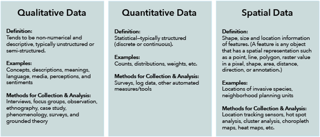
Starting with Data
To begin understanding what GIS can do for qualitative social science, we first define what we mean by qualitative, quantitative and spatial data. Table 1 below provides a brief summary. It’s important to note is that although spatial data is distinct, it can be combined to transform other types of data to become spatialized. That is, both quantitative and qualitative data can be combined with spatial data to associate shape, size, location, and other spatial information. For example, when a researcher collects attitudinal data in several neighborhood planning units, she can associate location information with each survey response. This spatialization of resident feedback would enable her to find additional patterns for analysis and comparison between neighborhoods.
Figure 1. Comparison of different data types
Qualitative Data & GIS
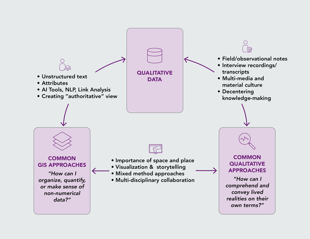
Qualitative data can mean different things to GIS professionals and qualitative researchers, and the different perspectives they bring frame how they encounter and work with such data. For many GIS practitioners, qualitative data often come in the form of things like open-text survey responses, ad hoc or unstructured feedback, or user-defined attributes. Additionally, AI tools have been developed that can automatically extract certain kinds of information from documents, images, or video, or that can score sentiment, which can all then be spatialized, if not already. In such contexts, qualitative data are utilized as yet another kind of data source, which must be collected, classified, and extracted so that they can be easily integrated into GIS tools/workflows. Generally, the goal behind this is to create a single “authoritative” view from the data that is used to inform various kinds of action or decisions. As such, the primary concern typically driving how GIS practitioners interact with qualitative data is: “How can I organize, quantify, or make sense of non-numerical data?”
Figure 2. Multiple meanings of qualitative data
However, to people like human geographers, sociologists, anthropologists, or many other researchers, qualitative data means something quite different. From their point of view, such data consists of things like notes and reflections generated through field-based observation, interview recordings and their corresponding transcripts, photos or videos taken by the researcher or participants, or any number of digital or material things relevant to the project at hand.
In other words, unlike the single, authoritative view from the data that a lot of GIS work aims to create, qualitative researchers are often focused on understanding things from multiple perspectives. This means that many qualitative researchers often use participatory data collection methods that empower participants to become research collaborators who can generate data about their lives and better steer research priorities towards local concerns. The underlying question driving how many social researchers encounter qualitative data is generally: “How can I comprehend and convey the lived realities of our participants on their own terms?”
However, seeing the power of both GIS and qualitative data, in recent years researchers and practitioners across GIS, geography, and social science fields continue to seek new ways to understand the importance of space and place and to use new technologies to uncover insights. Additionally, they are also looking for novel ways to visualize and analyze their data, and other ways to tell stories about the relationships between people and places, oftentimes with the aim of communicating to fresh audiences.
Learn More
A variety of resources for learning more are available, including software, data, and training.
The Enhancing Qualitative Social Science Research with GIS ArcGIS StoryMap serves as a guide for using Esri’s technology to conduct qualitative social science research. (Select “Tools” or “Resources” from the header to jump directly to those sections.)
The workshop Enhancing Qualitative Social Science Research with GIS explores the ways researchers from various disciplines have combined qualitative and GIS frameworks and how ArcGIS can be used across the lifecycle of qualitative research projects.
The Esri Social Science website provides articles showcasing research and information about events where social scientists can learn from and collaborate with their peers.
Featured Articles is a special section of the AAG Newsletter where AAG sponsors highlight recent programs and activities of significance to geographers and members of the AAG. To sponsor the AAG and submit an article, please contact Julie Ische jische [at] aag [dot] org.
By Esri Social Science Collaborative (Jennifer Mendez, Diana Lavery, Kyle Jones, Lakeisha Coleman, Lain Graham)
Share
President's Column
Finally, a commitment to mitigate climate change and its effects
Credit: Ma Ti, Unsplash
On Wednesday August 10, AAG alerted its U.S. members to urge our representatives to pass the Inflation Reduction Act, a bill that promised the most major investment in climate action that the United States has ever made. On August 16, 2022, President Biden signed that bill into law. It is being hailed as “the most ambitious climate bill in United States history.” This law has been a long time coming, is different in many ways from the original Build Back Better Bill and has a number of controversial elements that can and should be debated. As its name suggests, it is more broadly focused than climate change but, of relevance to our society is that it provides $369 billion in funding to mitigate climate change and its effects. The Act offers a multi-level approach to solutions, employing both science and technology. Its incentives, on the one hand, are designed to encourage companies to produce more renewable energy; and on the other, the rebates and credits are intended to help individuals to take advantage of these greener energy sources.
What does the Act provide?
An important aspect of this Act is that its provisions target actions that can have rapid results, significant reduction of emissions over a short time period. Princeton’s REPEAT Project’s Preliminary Report suggests that the provisions of the Inflation Reduction Act will put the United States on track to reduce its greenhouse gas (GHG) emissions to roughly 40 percent below 2005 levels by 2030, i.e within the next eight years. More concretely, cumulative GHG emissions will be reduced by about 6.3 billion tons over the next decade, i.e through 2032. Such a reduction will have a significant impact on global atmospheric GHG concentrations since the United States is the second largest emitter of carbon dioxide in the world, having been outstripped by China in recent years.
Mitigation of climate change depends heavily on the reduction of emissions from fossil fuel-based energy use. However, we need energy to survive in this world that we have constructed. This means that as we reduce our dependence on fossil fuels, we must look to alternative energy sources. The Inflation Reduction Act provides support for this transition. Specifically, this Act provides incentives for clean technology manufacturingto deploy more solar, wind, and batteries on the grid, extending existing credits another 10 years. It also provides tax credits for individuals for clean household choices such as heat pumps and solar power, as well as significant tax breaks for purchasing electric vehicles, making electric vehicles more accessible for the middle- and lower-income population. It provides funding for forest resilience, water, and habitat projects, aimed at stemming the loss of important sources of carbon sequestration.
Addressing Environmental Justice
Climate change affects everyone for sure, but it does not affect everyone equally. It bears repeating that low-income communities and communities of color are disproportionately affected. These are people who have contributed very little to the factors that have spurred climate change and do not share in the spoils of industry, but their communities are polluted and depressed by the industries that rely heavily on fossil fuels and they are the most likely to be most adversely affected by climate change impacts. Any action to mitigate the effects of climate change must offer solutions that are centered on the needs of these communities, and they must involve the communities in creating these solutions. The Inflation Reduction Act provides billions for environmental justice actions, including $27 billion for a new Greenhouse Gas Reduction Fund to support clean projects inlow-income communities and communities of color that are hardest hit by climate change; plus, a new $3 billion block grant program for neighborhood access and equity for community groups, tribes, and local or state governments; and $3 billion directed toward reconnecting communities that were divided by highways. However, the Act contains compromises that may result in worsening of the conditions under which racially and economically disadvantaged communities currently live, thereby negating its potentially positive aspects.
Is this Act sufficient?
With good reason, a question being hotly debated is — Is the Act sufficient?Clearly, it isn’t. First, its potential impact on GHG emissions (40% reduction) while significant and desirable falls short of the President’s 2021 pledge of a 50% reduction over 2005 levels by 2030. Second, and not necessarily secondary in importance, the Act contains compromises that weaken the potential of its environmental justice actions. This Act, while not perfect, is a start. It represents a significant commitment of resources from the government, and an opportunity for action.
The path of climate change mitigation is long and complex. We did not wake up overnight to find that the climate has changed. No: by our actions, we (noting that this “we” does not include the communities that have contributed little to climate change) systematically set the agents of climate change into motion over a long period of time and the damage is severe. But all is not lost. We have the technology, the resources and the will to slow that change and give us a chance to develop some resilience. However, it is going to take time and it will involve a variety of approaches.
This Act provides resources for us to do some of that work and gives us at least a start. We now must make sure that those aspects of the Inflation Reduction Act that address the mitigation of climate change and its effects are activated.And it is of paramount importance that we seek any opportunity to ensure that the needs of the most vulnerable and the worst affected among us are addressed, and that their contributions form part of the solutions. The work of climate justice is not done. The momentum that we will inevitably gain from those actions can be used to agitate/advocate for more efforts to combat climate change. Forty percent reduction is a good start, but further reduction is needed.
One last word
Transitioning from fossil fuel energy to green energy sources facilitated by the Inflation Reduction Act will reduce GHG emission no question, but it will not solve all of our environmental problems, including that of climate change. Ultimately, in order to reduce our environmental impact, we have to reduce our dependence on energy. Here is where the triplet — Reduce, Reuse, Recycle — becomes relevant. We pay a lot of attention to Recycle, and we should. Reduce and Reuse get short shrift by comparison. I would argue that we should first pay attention to Reduce, there is a good reason why it is the first word of the triplet. We should consider how much we consume in order to determine what changes we have to make individually and then devise ways in which we can act to reduce our dependence on materials that require energy use for production.
Please note: The ideas expressed in the AAG President’s column are not necessarily the views of the AAG as a whole. This column is traditionally a space in which the president may talk about their views or focus during their tenure as president of AAG, or spotlight their areas of professional work. Please feel free to email the president directly at raphael [at] geog [dot] ucla [dot] edu to enable a constructive discussion.
Share
Register for Free
Create an account to get free access to exclusive AAG content.
AAG Members get exclusive access to publications, prominent journals, unique advocacy, grant, scholarship and professional opportunities with access to industry focus communities, and event discounts, including our annual meeting.
Some content may only be accessible if you belong to specific Specialty or Affinity Groups. You can still update your membership below. You will need to go through the Join flow, but you do not need to repurchase your membership unless it is expired or about to expire.
To provide the best experiences, we use technologies like cookies to store and/or access device information. Consenting to these technologies will allow us to process data such as browsing behavior or unique IDs on this site. Not consenting or withdrawing consent, may adversely affect certain features and functions.
Functional
Always active
The technical storage or access is strictly necessary for the legitimate purpose of enabling the use of a specific service explicitly requested by the subscriber or user, or for the sole purpose of carrying out the transmission of a communication over an electronic communications network.
Preferences
The technical storage or access is necessary for the legitimate purpose of storing preferences that are not requested by the subscriber or user.
Statistics
The technical storage or access that is used exclusively for statistical purposes.The technical storage or access that is used exclusively for anonymous statistical purposes. Without a subpoena, voluntary compliance on the part of your Internet Service Provider, or additional records from a third party, information stored or retrieved for this purpose alone cannot usually be used to identify you.
Marketing
The technical storage or access is required to create user profiles to send advertising, or to track the user on a website or across several websites for similar marketing purposes.


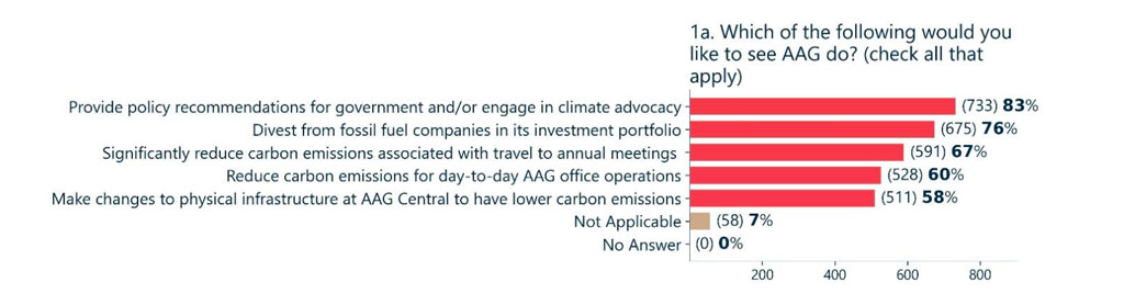


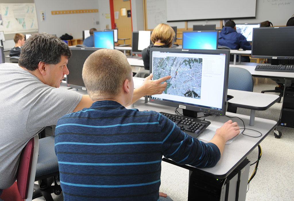

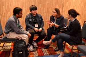 AAG currently seeks volunteers encompassing a wide range of professional backgrounds, interests, and experiences to participate as Career Mentors during the 2023 Annual Meeting in Denver, CO. Career mentoring provides an open forum for students and job seekers to receive one-on-one and small-group consultation about careers in a variety of industries and employment sectors. To volunteer, please contact us at
  Please consider submitting applications or nominations to four AAG grants and awards with approaching deadlines, two for students and one for career geographers. The
  The most recent issue of the Annals of the American Association of Geographers has been published online (
 The most recent issue of The Professional Geographer has been published online (
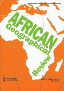 New issue of African Geographical Review

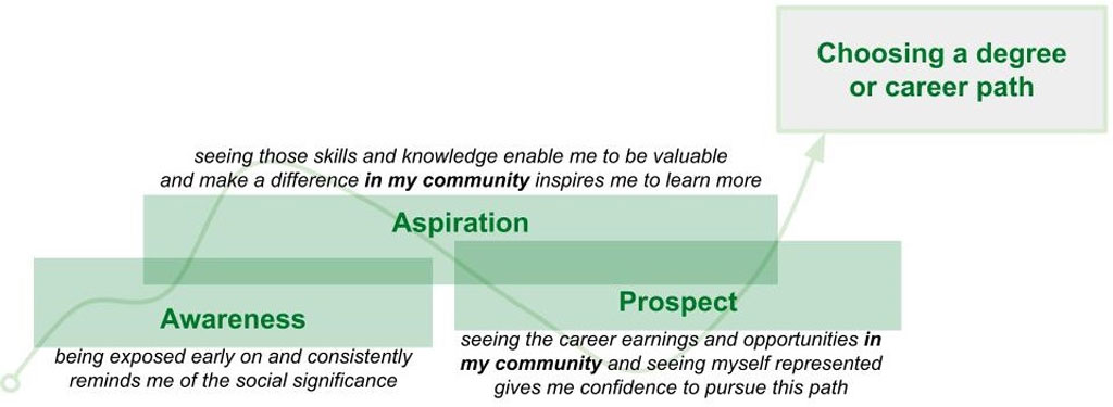
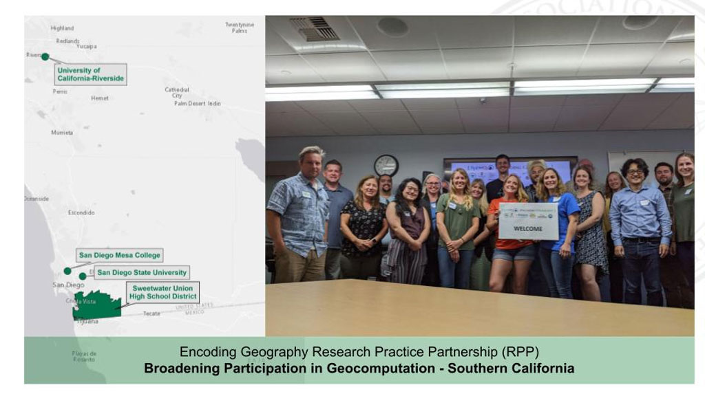
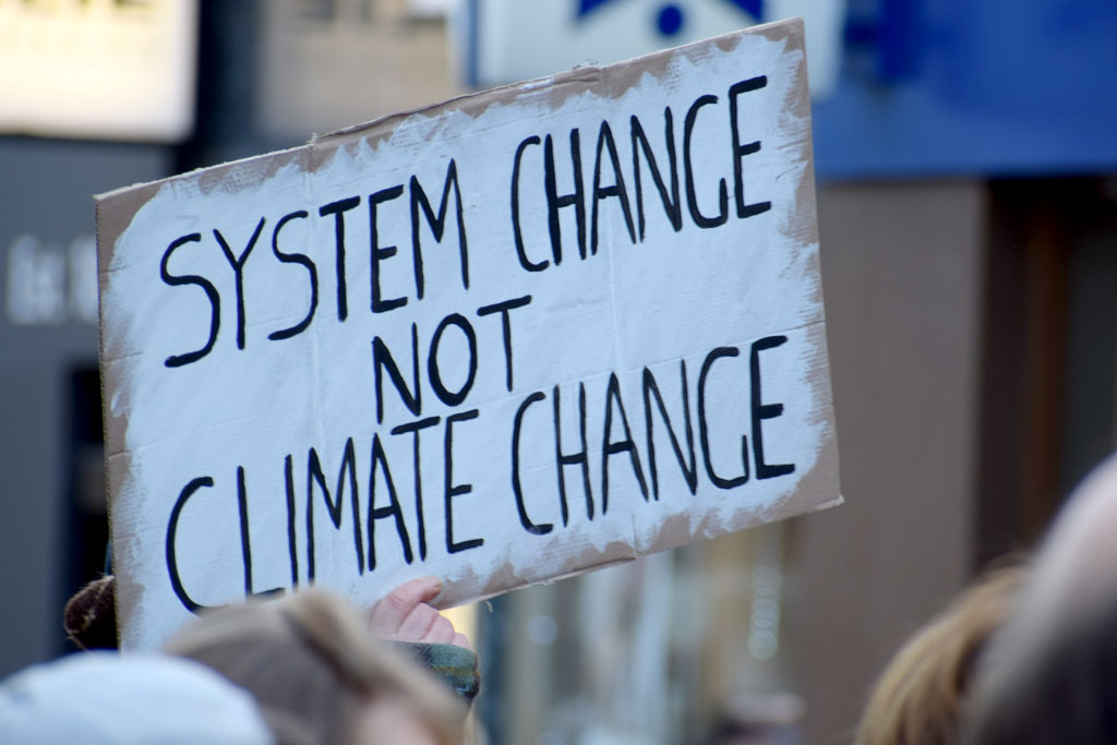
 Last week, the Consortium of Social Science Associations