Enhancing Qualitative Social Science with GIS
By Esri Social Science Collaborative (Jennifer Mendez, Diana Lavery, Kyle Jones, Lakeisha Coleman, Lain Graham)
Many people understand the power of GIS for quantitative research, but fewer know of its practical applications for qualitative social science work. In a broad effort led by Esri’s Chief Scientist, Dawn Wright, Ph.D., a number of researchers at Esri are looking at the many ways qualitative social science can benefit from GIS. While ArcGIS can help with an array of quantitative approaches, it also brings many capabilities to enhance qualitative methodologies to address longstanding issues of social and environmental concern. This article explores where and how common GIS approaches and common qualitative approaches intersect and provides resources for learning more.
Starting with Data
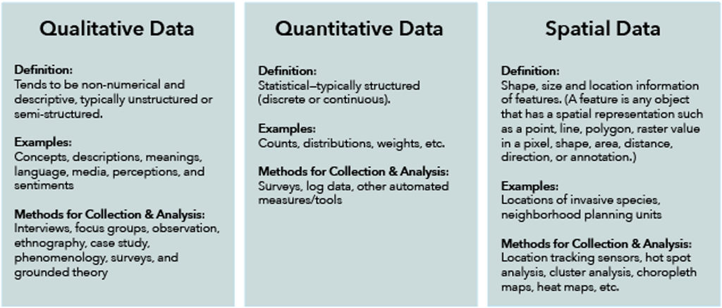
To begin understanding what GIS can do for qualitative social science, we first define what we mean by qualitative, quantitative and spatial data. Table 1 below provides a brief summary. It’s important to note is that although spatial data is distinct, it can be combined to transform other types of data to become spatialized. That is, both quantitative and qualitative data can be combined with spatial data to associate shape, size, location, and other spatial information. For example, when a researcher collects attitudinal data in several neighborhood planning units, she can associate location information with each survey response. This spatialization of resident feedback would enable her to find additional patterns for analysis and comparison between neighborhoods.
Qualitative Data & GIS
Qualitative data can mean different things to GIS professionals and qualitative researchers, and the different perspectives they bring frame how they encounter and work with such data. For many GIS practitioners, qualitative data often come in the form of things like open-text survey responses, ad hoc or unstructured feedback, or user-defined attributes. Additionally, AI tools have been developed that can automatically extract certain kinds of information from documents, images, or video, or that can score sentiment, which can all then be spatialized, if not already. In such contexts, qualitative data are utilized as yet another kind of data source, which must be collected, classified, and extracted so that they can be easily integrated into GIS tools/workflows. Generally, the goal behind this is to create a single “authoritative” view from the data that is used to inform various kinds of action or decisions. As such, the primary concern typically driving how GIS practitioners interact with qualitative data is: “How can I organize, quantify, or make sense of non-numerical data?”
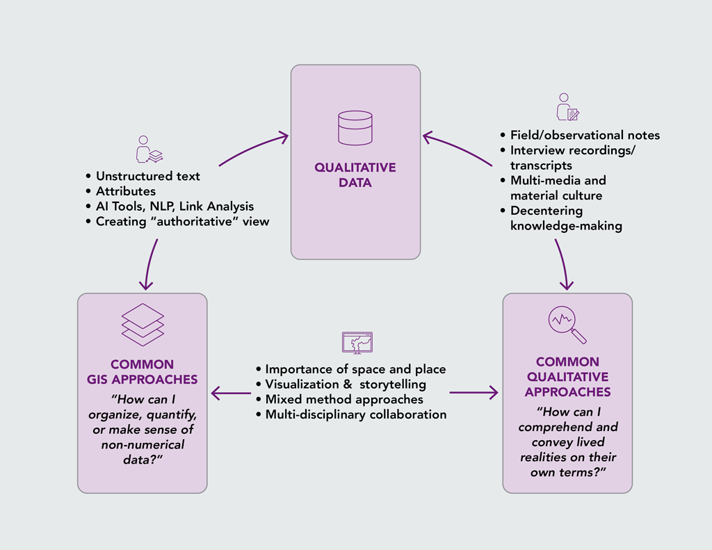
However, to people like human geographers, sociologists, anthropologists, or many other researchers, qualitative data means something quite different. From their point of view, such data consists of things like notes and reflections generated through field-based observation, interview recordings and their corresponding transcripts, photos or videos taken by the researcher or participants, or any number of digital or material things relevant to the project at hand.
In other words, unlike the single, authoritative view from the data that a lot of GIS work aims to create, qualitative researchers are often focused on understanding things from multiple perspectives. This means that many qualitative researchers often use participatory data collection methods that empower participants to become research collaborators who can generate data about their lives and better steer research priorities towards local concerns. The underlying question driving how many social researchers encounter qualitative data is generally: “How can I comprehend and convey the lived realities of our participants on their own terms?”
However, seeing the power of both GIS and qualitative data, in recent years researchers and practitioners across GIS, geography, and social science fields continue to seek new ways to understand the importance of space and place and to use new technologies to uncover insights. Additionally, they are also looking for novel ways to visualize and analyze their data, and other ways to tell stories about the relationships between people and places, oftentimes with the aim of communicating to fresh audiences.
Learn More
A variety of resources for learning more are available, including software, data, and training.
- The Enhancing Qualitative Social Science Research with GIS ArcGIS StoryMap serves as a guide for using Esri’s technology to conduct qualitative social science research. (Select “Tools” or “Resources” from the header to jump directly to those sections.)
- The workshop Enhancing Qualitative Social Science Research with GIS explores the ways researchers from various disciplines have combined qualitative and GIS frameworks and how ArcGIS can be used across the lifecycle of qualitative research projects.
The Esri Social Science website provides articles showcasing research and information about events where social scientists can learn from and collaborate with their peers.
Featured Articles is a special section of the AAG Newsletter where AAG sponsors highlight recent programs and activities of significance to geographers and members of the AAG. To sponsor the AAG and submit an article, please contact Julie Ische jische [at] aag [dot] org.
By Esri Social Science Collaborative (Jennifer Mendez, Diana Lavery, Kyle Jones, Lakeisha Coleman, Lain Graham)