The AAG is pleased to announce the recipients of the three 2018 AAG Book Awards: the John Brinckerhoff Jackson Prize, the AAG Globe Book Award for Public Understanding of Geography, and the AAG Meridian Book Award for Outstanding Scholarly Work in Geography. The AAG Book Awards mark distinguished and outstanding works published by geography authors during the previous year, 2018. The awardees will be formally recognized at the Awards Luncheon during the 2019 AAG Annual Meeting in Washington, D.C.
The John Brinckerhoff Jackson Prize
This award encourages and rewards American geographers who write books about the United States which convey the insights of professional geography in language that is both interesting and attractive to lay readers.
David G. Havlick,Bombs Away: Militarization, Conservation, and Ecological Restoration (University of Chicago Press, 2018)
David Havlick’s Bombs Away takes us on a rich journey to some of the world’s best examples of former military lands undergoing ecological restoration. He probes the cultural and environmental consequences of this process and explores what happens to localities that were once bombed, fortified, and militarized spaces. The result is a beautifully-written and theoretically-informed narrative that exemplifies a new area of nature-society research, asks relevant questions about ecological restoration on former military lands, and illuminates an important, previously underappreciated type of cultural landscape, both in the United States and beyond.
The AAG Globe Book Award for Public Understanding of Geography
This award is given for a book written or co-authored by a geographer that conveys most powerfully the nature and importance of geography to the non-academic world.
Tara Patricia Cookson, Unjust Conditions: Women’s Work and the Hidden Cost of Cash Transfer Programs (University of California Press, 2018)
Tara Patricia Cookson’s outstanding book Unjust Conditions: Women’s Work and the Hidden Cost of Cash Transfer Programs is an elegantly written and accessible portrait of how rural women in Peru experience and cope with the often hidden and detrimental socioeconomic demands of a much-heralded development program. Through careful, self-aware ethnographic methods, Cookson (currently a Postdoctoral Research Scholar in the Department of Geography at the University of British Columbia) presents a powerful counter-argument to the fashionable yet problematic practice of “data-driven development”. Unjust Conditions should be required reading for students, scholars, the general public, and—most importantly—practitioners of development searching for innovative and socially just alternatives to conventional development thinking.
The 2018 AAG Meridian Book Award for Outstanding Scholarly Work in Geography
This award is given for a book written by a geographer that makes an unusually important contribution to advancing the science and art of geography.
Martin Doyle, Duke University, The Source: How Rivers Made America and America Remade its Rivers (W.W. Norton, 2018)
Martin Doyle’sThe Source is one of those rare books that advances both the science and art of geography. The Source is at once an environmental and political history of the United States. Doyle simultaneously provides an invaluable story of how rivers are intimately entangled with both the construction of the physical landscape, and an empirical study of how power has been etched onto that same landscape. Doyle adeptly picks apart some of the most intriguing connections among the various levels of governing bodies that are charged with dealing with water in the United States. The analysis shows how rivers not only contribute to the organization of a household via running water and indoor plumbing but also link to shaping cities beyond mere settlement, into the building of the nation itself. Well-researched and accessibly written, Doyle’s The Source embodies the spirit of the AAG Meridian Award.
Share
Hope Morgan
Education: Bachelor’s in Geography, Concentration in Earth Science (University of North Carolina at Greensboro), Certifications: GISP, Certified Floodplain Manager (CFM), Professional Land Surveyor (PLS) in North Carolina
Describe your job/position and some of the primary tasks and duties for which you’re responsible in this position. I have an extremely interesting job. I’ve been here for eleven years and it has morphed quite extensively. When I began I was the GIS manager and I managed all geospatial information that came into our office for either emergency response, floodplain mapping, or other applications through risk management. I am now the IT manager and GIS and IT work closely together, so my responsibilities include all applications including data with spatial association used inside of the risk management office. One of the biggest projects that I worked on was managing the collection of LiDAR data for the entire state of North Carolina, working with many federal, state, and local agencies, specifically the Department of Transportation. Hopefully by the end of this year we’ll have an entire surface to use for the state. Another was statewide collection of orthophotography in 2010 for the entire state.
Could you talk a little more about how those resources are being applied for risk management in the state? It sounds like a fascinating position that you’re in that’s gone through a lot of changes. In this field, we are constantly changing, constantly working to keep up with new technologies. We are working on a new project where they are processing 30 points per meter LiDAR, which is a massive amount of data. It requires updated software that can maintain and visualize that information so the public can use all of the information that we’ve gathered. The public in North Carolina has worked hard to make sure that they can utilize all of this information. It’s amazing to watch as people use the data for new and different things.
What substantive geographic knowledge is important and useful to know in your position? For example, this includes knowledge and understanding of geographic terminology and substantive concepts (e.g., alluvial plain, metropolitan area, ethnic group, tertiary economy, coniferous forest, geologic fault, etc.). I’m North Carolina-centric because I was born and raised here and I work for the state, so most of my working knowledge base of geography is based on North Carolina. With the LiDAR dataset, I’m working with many groups: forestry, Department of Transportation, commerce, property mappers that are creating plans at the local level. It helps to be able to understand the terminology that goes with each one of these groups. As we work through the different geography requirements for each one of these projects and processes, knowing the terminology is very important. The more you know, the easier it is to have a conversation. When I talk to students, I tell them, you don’t have to know everything, you’re going to learn a lot as you go, but you need that baseline of understanding so that when people start throwing terms at you, you understand what direction to go in and what research you need to do. One of the big projects we do is the flood plain mapping program, so I work with engineers quite often. I have learned more about hydrography, hydrology, water surface elevation, and other things that are relevant to this specific type of program. I use geography terms on a daily basis, often times without realizing I’m doing it.
When you started out in your job, coming out of your degree program, did you find that there were areas where you felt a little underprepared or needed additional training? Did you ever think “I wish I had more of that when I was a sophomore, or a junior, or a senior, in college,” or did you feel comfortable just learning as you went? I wish I would have paid a little more attention as a student. In school, it’s difficult because you’re in the middle of these classes, you’re tired, and you’re trying to get all of this stuff done. It’s important to try to stay focused and listen to what’s going on because every single thing that you do in school and every single class you take has some piece of information that you probably need to take with you.
In terms of how you’re working with technologies, in connection with some of those substantive areas of geography that you’ve been leaning on in your position, can you talk a little about how these connect or fit together? What are some applications that are being used now for risk management in the state and how is that department working with these technologies? On the emergency management side, we try to forecast what is going to happen during major events. We look at everything from hurricanes to nuclear boundaries to tornado paths to winter storms, and the biggest thing we are looking for is what’s in the way. If there is a flood, we look at who and how much is going to be in the way and what kind of damage is it going to cause. With storm surge, we try to figure out if the storm is going to cause some impact to the structure of the coast, such as erosion. In North Carolina, we are often looking at the Outer Banks and how they are impacted by storm surge. If the storm is going to run into structures, we look at water surface elevation and compare that to the building footprints to see how the water will impact the structures. That’s an example of how we use these technologies daily. We’re walking it all the way through a process from the physical to the impact to the dollar damage, and then we consider the people and the community to see how they can recover from this incident.
How would you describe the impacts of your work in this area of risk management on the state and in communities? Can you cite any specific examples in terms of positive impacts? Emergency management is built out of responders, so it is a group of people focused on solving problems like rescuing and helping people recover. Many people in emergency management are not used to using datasets to make decisions. We have worked very closely with our team members to answer questions ahead of events, planning makes it easier for them to respond to incidents that are occurring. After planning we automate as much as possible so that the answers the teams need automatically show up in our systems. Hurricane Matthew in 2016 was a good example. A large part of Hurricane Matthew was rain, and it rained a massive amount over a large portion of North Carolina. What we were able to do was use database decision making to respond to flooded areas. Our engineers could tell us when the water was going to arrive based on gages, so we knew where to send our limited resources as well as responders. I’m really proud of those first responders for working with us and taking on this new technology.
What is it about geography that inspires you and connects with your aspirations, both as a private citizen and as a professional in your field? In college, I wasn’t really sure what I wanted to do or where I wanted to go. I ended up looking at the courses I had taken and realizing that geography was where I had spent most of my time. I got my first job at a photogrammetry company after visiting it during one of my college classes. So my career began in photogrammetry and remote sensing, where I was working with orthophotography and planimetric collection. I am a spatial person, so I understand through visualization and pictures, and this work just really clicked for me. I guess that job was sort of my first a-ha moment that basically led me to this very hopeful path, where I try to have a lot of impact.
As I moved to state government, I have been so lucky to work with different groups of people that are doing amazing work in the state. We have a vast amount of work that’s being done with different imagery at the local level, day-to-day. And then on the emergency management side, with the ability to help during an event, we know that this information saves lives by helping us move people out of the way. We have been able to evacuate hospitals and jails and move towns that basically were going to be underwater, and we got those people out ahead of time. I am very lucky to be a part of that and do something that’s really helping North Carolina.
The other thing that is a big piece of what I want to do is make everybody’s job easier. I feel like this data and this understanding of how this information is built really does make things more efficient and makes decisions easier.
Is there anything else you’d like to share, in terms of general advice? My advice is to use the data that is provided by others. I really push to use the data that is available, for universities to take this data research and learn from it. They should learn how it works and make it do new and better things because it is a base set of information that can change how people think. Wherever you are, you can use the data that is available and learn how that data can make a change in how people see the world.
Every month the AAG compiles a list of newly-published books in geography and related areas. Some are selected for review in the AAG Review of Books.
Publishers are welcome to send new volumes to the Editor-in-Chief (Kent Mathewson, Editor-in-Chief, AAG Review of Books, Department of Geography and Anthropology, Louisiana State University, Baton Rouge, LA 70803).
Anyone interested in reviewing these or other titles should also contact the Editor-in-Chief.
PLEASE NOTE: Due to current public health policies which have prompted the closing of most offices, we are unable to access incoming books at this time. We are working on a solution during this transition and will continue our new books processing as soon as we can. In the meantime, please feel free to peruse previous books from our archived lists.
AAG Election Underway and Looking Forward to the Annual Meeting in Washington DC in April!
The AAG election season is underway! This week, AAG members around the globe received email links to log on and vote for 2019-2020 AAG officers and committee members. Balloting is open from 30 January to 21 February, so please remember to take a few minutes to dig out that email, vote, and be heard! I thank the AAG nominating committee for providing us with a highly distinguished slate of candidates, and I especially thank the candidates for their willingness to stand for office and their commitment to serve the AAG should they be elected. So now it is up to you, fellow AAG members, to get out and vote to select the future leaders of our association!
Borderline Insanity: The Threat from the North
The record-breaking 35-day U.S. Government partial shutdown was finally suspended on 25 January, until 15 February 2018 for negations on border security. I hope that the White House can come to an agreement with our Congress on how best to ensure our security, avoid another partial government shutdown, and treat those seeking refuge humanely and with dignity. I truly hope that government workers, including thousands of professional geographers, are never used as political hostages again. On a related front, four women who are members of a humanitarian group whose intent is to save lives of asylum seekers lost in the desert with no water, where hundreds have already died, have been convicted on 18 January 2018 of entering a protected federal refuge in Arizona and leaving behind food and water jugs. AAG and APCG have been closely following the situation for a humanitarian geographer also caught up in this sweep, and for our colleague’s sake we have been careful to not interfere with the case until action is requested. Individuals have been staying in contact, and have contributed to a defense fund. More volunteers go on trial this spring.
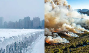
Chicago (polar vortex), Australia (fires)
Our nation’s attention was diverted from immigration issues and the potential for a border wall on the U.S.-Mexico border this past week, to a more serious and dangerous threat streaming across the northern border of the U.S. This threat took the lives of at least 21 people, and made no distinction between college students, package delivery workers, jail inmates, and homeless people. The threat was the Polar Vortex, and it unleashed record-breaking cold on about 70 percent of the U.S. population this past week. The White House response was to tweet about the record cold and ask essentially, “what the (heck) is going on with global waming (sic)? Please come back fast, we need you.” We need not look too far to find it … for at the very same time, the White House forgets that it is summer in the Southern Hemisphere, where in parallel, extreme heat fanned wildfires in Australia. Of course, with a flat earth, one never worries about the other side. What the White House does not care to understand is that Polar Vortex disruption can be connected to atmospheric carbon imbalances, and global warming splitting the polar jets (read more at PBS.org). NOAA also explained it elegantly. The White House’s purposeful mischaracterization of how the atmosphere works feeds the flames of climate denial, and puts our citizens, economy, and environment in physical danger. We geographers need to continue to communicate climate change science to the general public and to policy makers because it is every global citizen’s right to benefit from scientific knowledge. We must also continue our research to understand and communicate the teleconnections of global warming, atmospheric circulation, and extreme weather events, and to protect that right to conduct our scientific inquiry.
Closing Thoughts: Looking Forward to Annual Meeting in Washington DC in April!
As I noted in my first presidential column, imagine what 12,000-plus geographers can do together to make a better world. We will be meeting in just two months in Washington, D.C. to share our ideas and to make a difference with Geography! Although the call for AAG annual meeting paper sessions and individual paper and poster abstracts is now closed, participants may still edit their entries until 23 February 2019. Poster session organizing is open until 14 February 2019. The annual meeting schedule is now posted so you can make your travel plans accordingly. In addition to the opportunity to share your exciting geography research at paper and poster sessions, AAG is planning many special events for the 2019 Annual Meeting.
I am very happy to announce the full slate of our presidential plenary panel who will join me to kick off the AAG meetings on 3 April 2019: Dr. Douglas Richardson (AAG Executive Director); Dr. Mei-Po Kwan (U. Illinois at Urbana-Champaign Geography Professor), Dr. John McNeill (University Professor of History, Georgetown U.; American Historical Association President), Dr. Heather Viles (Oxford University Geography Head and Professor), and Dr. Rita Colwell (University of Maryland College Park Distinguished University Professor, Cell Biology and Public Health).
Please do plan to join us at 6:20 pm on 3 April 2019 to hear opening remarks from AAG Executive Director Dr. Douglas Richardson. This will be an historic moment you will not want to miss, as it will be Doug’s last opening session welcome before he retires from the directorship in early 2020. We thank and congratulate him for his dedication and leadership!
Next, you will hear from our distinguished panelists. These eminent scholars in Human Geography and Physical Geography, Environmental History, and Biological Sciences will address the intersection of their research and the themes of our meeting: “Geography, Environmental Science, Human Health, and Human Rights.”
We will conclude our opening session by recognizing our 2019 Honorary Geographer Dr. Rita Colwell, who will also address the audience as a distinguished panelist.
Other special events during the annual meeting will include a keynote address by former U.S. Attorney General Eric H. Holder, Jr. (April 4), and on 5 April we will honor The Librarian of Congress Dr. Carla Hayden with the AAG Atlas Award, followed by her keynote address.
It will be my deepest honor to welcome all of you in Washington, D.C. in April, just in time for the cherry blossoms.
Until then I wish you a warm and cozy Groundhog Day weekend!
— Sheryl Luzzadder-Beach
President, American Association of Geographers
Professor of Geography and Fellow of the C.B. Smith Sr. Centennial Chair in U.S. Mexico Relations, University of Texas at Austin
Please share your ideas with me at: slbeach(at)austin(dot)utexas(dot)edu
Three new interns have joined the AAG staff this spring semester! The AAG would like to welcome Matilda, Crystal, and Jessica to the organization.
Matilda Kreider is a junior at George Washington University pursuing a B.A. in political communication with a minor in geography. Matilda is interested in communicating science to the public through museums and/or science journalism and is considering M.A. programs in geography, museum studies, or science writing. Matilda previously interned at The Wilderness Society, where she advocated for the protection of public lands and did research on race and representation in environmentalism; at the Connecticut River Museum, a small regional historical and geographical museum; and at Stewart B. McKinney National Wildlife Refuge under the U.S. Fish and Wildlife Service. Matilda attributes her love of nature to growing up on the beach in Connecticut and her concern for the environment to viewing the effects of sea level rise up close and personal. Her favorite places in DC are Eastern Market, Second Story Books, the Phillips Collection, the World War II Memorial, and Tasty Kabob food truck.
Crystal King is a senior at Michigan State University, pursuing a B.S. in Economic Geography and a Cognate in Business. Crystal previously interned at a venture capital fund in New York City and hopes to combine her interests in business and geography by studying international business in the future. In her spare time, Crystal enjoys live music, a good book, and spending time with animals. She is originally from Detroit, but her favorite place to travel is London.
Jessica Gillette is a Sophomore at the George Washington University pursuing a B.A. in Geography with a minor in G.I.S., and a B.A. in International Affairs with a focus on Security Policy. Currently she’s planning on furthering her Geographic skills in graduate school. While at the AAG she will be working on projects related to the Guide to Geography Programs, the Annual Meeting, and the archive of AAG publications in the Library of Congress. While not at work or school she can be found watching the Houston Texans or exploring D.C.
If you or someone you know is interested in applying for an internship at the AAG, the AAG seeks interns on a year-round basis for the spring, summer, and fall semesters. More information on internships at the AAG is also available on the Jobs & Careers section of the AAG website at: https://www.aag.org/internships.
Share
President's Column
Share Your Science, and Make a Difference with Geography at the AAG Annual Meeting in April 2019
Happy New Year, Geographers and Friends of Geography! There is still much for us, as fellow AAG Members, to do and to accomplish, and what better month than January to re-commit ourselves to serving people and the planet, when we celebrate Civil Rights Leader Martin Luther King Jr.’s Birthday. It is hard to believe we are already halfway through the fiscal year, whether you are still enjoying the academic winter break, or are just returning from the holidays with family and friends. I do ask that we stop to recognize our fellow Geographers in the federal workforce who, at the time of this writing, are experiencing one of the two longest Government shutdowns in U.S. history, and we hope it is resolved soon for their sake and for the greater good of our country. Their absence is felt at the conference I am currently attending, the Soil Science Society of America (SSSA) International Meetings in San Diego as I write this column.
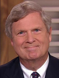
Thomas Vilsack, former U.S. Secretary of Agriculture and former Iowa Governor
The opening SSSA session keynote speaker was former U.S. Secretary of Agriculture and former Iowa Governor Thomas Vilsack, who spoke on “Climate Smart Agriculture, Good for the Farm and Good for the Land.” He exhorted us to share our science not only with fellow scientists, but with the broader public and policy makers. He also emphasized that we actively address climate change, in the context of this meeting of course in agriculture, and especially in food security as the planet’s population grows, and to address the loss of arable land as urban areas expand to accommodate growing populations worldwide. The momentum to make a difference across disciplines is clear, from academic and professional association to association, not only in climate change, but also in addressing harassment and discrimination head on as SSSA also did in their meeting opener, and we are witnessing a sea change of scientific activism. We Geographers will take up the baton at our AAG Meetings in April in Washington D.C., so be ready for your turn around the track! As Secretary Vilsack pointed out, there is much competition now with misinformation widely available on social media, and scientists in particular must continue to provide evidence-based, peer-reviewed science that can stand the test of time and rise above the sea of misinformation. Scientists cannot abandon the scientific method in our activism, we must use our activism to embrace it and educate the public and policy makers on its rigor and benefits. This is where the human right to benefit from science helps us to make a strong case.
The AAG Meeting Online Program is now posted so it is time to make your travel plans! I am excited that our AAG Annual Meeting is coming together so well for April in Washington D.C., and remind all of you that there is still time to submit poster abstracts by 31 January 2019, and to organize poster sessions by 15 February 2019. Posters and sessions may also be designated by submitting authors as one of the three Special Themes of the 2019 Annual Meeting: Physical Geography in Environmental Science, Geographic Information Science and Human Health, and Geography and Human Rights. Paper abstracts and sessions are also open for edits until 24 February 2019. My thanks go out to the AAG staff and our theme-organizing committees for their work on the program, and most of all, you, the AAG members, for submitting your exciting research to share, you are the stars of our meeting!
To open the Annual Meeting, please join me for the 2019 AAG Presidential Plenary Opening Session, on 3 April 2019 at 6:20 pm. It is one of many special events AAG has planned for us. The Plenary will address “The Intersection of Geography, Environmental Science, Human Health, and Human Rights,” featuring distinguished panelists addressing how their research fields intersect with Geography and these three meeting themes. Our invited panelists include distinguished scholars in human and physical geography, environmental history, and biological sciences. It will be my honor to welcome you all to the meetings, and to preside over our panel of distinguished guests including Dr. Mei-Po Kwan (U. of Illinois Geography Professor), Dr. Heather Viles (Oxford University Geography Head and Professor), and 2019 AAG Honorary Geographer Dr. Rita Colwell (University of Maryland College Park Distinguished University Professor, Cell Biology and Public Health), who will receive her award and address our gathering at this event. Stay tuned for more details!
Remember, again, to check for your paper presentation time and other events to attend in the Online Program and make your travel plans! I look forward to seeing you in Washington D.C., April 3-7, 2019.
— Sheryl Luzzadder-Beach
President, American Association of Geographers
Professor of Geography and Fellow of the C.B. Smith Sr. Centennial Chair in U.S. Mexico Relations, University of Texas at Austin
Please share your ideas with me at: slbeach(at)austin(dot)utexas(dot)edu
It is with a heavy heart that I write to inform each of you that Dr. Lawrence Estaville, founding member of the Ethnic Geography Specialty Group, had died.
Lawrence served in the academy as a professor, scholar, and administrator for more than 40 years with positions in Wisconsin, California, South Carolina, and Texas. During his career, Lawrence was a prolific scholar, steadfast mentor and educator, and an effective administrator. While in no way inclusive, I would like to highlight some of Lawrence’s many accomplishments during his unparalleled career and life. Lawrence led the establishment of three PhD programs at Texas State University and aided in the founding of the James and Marilyn Lovell Center for Environmental Geography and Hazards Research and the Gilbert M. Grosvenor Center for Geographic Education. He published 10 books (with an additional co-authored monograph forthcoming), 36 peer-reviewed articles, 19 peer-reviewed book chapters, and presented 92 conference papers. An effective fundraiser, Lawrence raised over $6-million in grants and raised funds to support graduate students and conferences. He worked closely with the Race, Ethnicity, and Place Conferences and with the conference creator and his dear friend Dr. John Frazier.
Above all, Lawrence would tell you that his passion was teaching. He taught nearly 40 courses during his career and was a steadfast advocate for students. Diversity of students and ideas was a cornerstone of his teaching. Lawrence’s love of cinema led him to include assignments involving important films in several of his undergraduate courses. He was often recognized as a favorite professor by both undergraduate and graduate students. He advised three doctoral students and several masters students to the successful completion of their degrees. As one of those doctoral students, I will share that Lawrence’s mentorship did not end at the culmination of my graduate degree but rather turned into a life-long duty for him.
Lawrence was an award-winning professor with recognition at the highest level. I highlight a few here. Lawrence was a recipient of the Distinguished Teaching Award in 1985 and the Distinguished Mentor Award in 2012 from the National Council for Geographic Education. He was honored in 2011 with the Outstanding Scholarship and Service Award from the Business Geography Specialty Group – a group that he led in establishing. From our Ethnic Geography Specialty Group, Lawrence was the recipient of the Distinguished Scholar Award in 2015 and the Distinguished Ethnic Geographer Career Award in 2010. He received the Enhancing Diversity Award from the American Association of Geographers in 2016. Most recently, on November 16, 2018, Lawrence was the recipient of the highest faculty honor and title bestowed by the Texas State University System – Regents’ Professor.
I will add that one of the things that Lawrence was most proud of, especially toward the end of his career, was his service to the National Marrow Donor Program and his establishment (with Yvonne Ybarra and Angelika Wahl) of the Texas State Cancer Advocacy Movement for Colleges and Outreach (CAMCO). The efforts of this state-wide alliance resulted in tens of thousands of student marrow donors and, most importantly, the saving of over 50 lives through marrow matches – including several children. He shared privately with me years ago, after his successful fight with leukemia, that he felt that he just had to do something if he “beat this thing,” especially after seeing what he saw at M.D. Anderson. He did.
These few paragraphs only scratch the surface of Lawrence Estaville’s vast career accomplishments. Lawrence was very private about his valiant fights with cancer.
On Wednesday, December 5, 2018, Lawrence was honored with a Texas State University presidential reception for his Regents’ Professor distinction in San Marcos, Texas. Although he was a little thinner and in a wheel chair, Lawrence was vibrant and excited to speak to all who came to congratulate him. His contagious, deep laughter could be heard throughout the room as he reminisced and joked with friends and colleagues. I remember that he displayed his Regents’ Professor medallion proudly over his suit jacket adjusting it for pictures. He would later tell me that he was so very thankful for the experience and for all his friends near and far. He said that the award was “the cherry on top” of what he said was a great life and career.
I visited him again a few days later in his home. Lawrence, in characteristic fashion, wanted to talk more about me, my family, and our friends than himself. Always the hosts, the Estaville’s had refreshments out for me. When I commented on not needing to have refreshments out he said, “Oh Edris, that is my beautiful wife Sandra who put those out.” I said, “You are one lucky man.” He replied, “You’re telling me.” Lawrence’s deepest love and admiration for his wife, Sandra, remains an example to us all.
A professor and educator until the end, Lawrence was afraid that he would not be able to complete his Ethnic Geography course this semester and see his students’ presentations. Angelika Wahl, his dear friend and colleague from the department at Texas State suggested that he could Skype-in to see and grade the final presentations which excited Lawrence greatly. With the assistance of Yongmei Lu, TX State Geography Department Chair and cherished friend, Lawrence was able to finish his course this semester – a duty he would tell me that he felt he owed his students… to finish what he started. He was very thankful for that.
In one of our conversations, Lawrence did lament that there would be many that he would not be able to say goodbye to personally and he hoped that everyone understood. I, of course, reassured him that all would. He shared with me that he felt that he had lived a wonderful life and was thankful for every moment of it.
Lieutenant Colonel (Ret.), professor, scholar, mentor, colleague, and friend Dr. Lawrence Estaville passed away on the morning of December 20, 2018 with his loving wife Sandra by his side. He was 74 years old. Lawrence is survived by his wife Sandra and his daughter Deborah. He is survived by dozens of colleagues and friends who he collaborated with over his long career. Finally, Dr. Lawrence Estaville is survived by thousands of students who are better for their time spent with him – in the classroom and beyond.
Per Lawrence’s wishes, there will not be a funeral. The family has asked in lieu of flowers, to consider contributing to the many scholarships he supported/funded at Texas State (geography specific scholarship information: https://donate.txstate.edu/givingsearch) or to the Be the Match Foundation (https://bethematch.org/support-the-cause/donate-financially/). Those who wish may also consider donating to the EGSG’s newly established student travel fund in Lawrence’s memory (If you wish to donate to the EGSG student travel fund please contact me at emontalvo@cameron.edu).
As we take the time to remember Lawrence in the next few months and at the AAG meeting in Washington D.C., I know that our friend and colleague wouldn’t want us to spend too long mourning him. Instead, I believe that Lawrence would want us to continue to educate and serve students and each other to the best of our ability. He did.
Paradise Lost, Global Warming Report, and Geographers Speak Up
By Sheryl Luzzadder-Beach
As AAG President, Dr. Luzzadder-Beach, notes, recently we have marked the occasion of the containment of devastating fires in California and the publication of the Fourth National Assessment on climate change. In light of these events, she ends her column with hope, thanking those who have contributed abstracts to the AAG Annual Meeting and wishing everyone a “peaceful and rejuvenating holiday season.”
AAG Names Rita Colwell as the 2019 Honorary Geographer
Every year the AAG bestows its Honorary Geographer Award on an exceptional leader, to recognize excellence in the arts, research, teaching, and writing on geographic topics by non-geographers. The AAG has named Rita Colwell, the first woman to be director of the National Science Foundation (NSF), as its 2019 AAG Honorary Geographer. Rita Colwell currently is a distinguished university professor at the University of Maryland at College Park and at Johns Hopkins University Bloomberg School of Public Health. A pioneer for women in science, Colwell’s internationally recognized research primarily focuses on water and health with particular focus on cholera and infectious disease.
The advice of a mentor can be instrumental in preparing young geographers for success in today’s competitive job market. The AAG seeks professional geographers representing the business, government, nonprofit and academic sectors to serve as volunteer Career Mentors during the 2019 AAG Annual Meeting in Washington, DC.
Career Mentoring sessions will be held each morning of the conference from 10:00 – 11:40 AM in the Jobs & Careers Center. Mentors are expected to answer questions and provide general career advice to students and job seekers interested in learning more about industries that employ geographers, the work geographers perform and strategies for getting into the field.
For additional questions and to volunteer, please contact Mark Revell at the AAG at mrevell [at] aag [dot] org by February 15th, 2019.
“Focus on Washington, DC and the Mid Atlantic” is an ongoing series curated by the Local Arrangements Committee to provide insight on and understanding of the geographies of Washington, DC and the greater Mid Atlantic region in preparation for the 2019 AAG Annual Meeting.
The Chesapeake Bay: Destruction and Rehabilitation in the Nation’s Largest Estuary
A voyage on a traditional Hawaiian voyaging canoe provides the setting for RDK Herman of the National Museum of the American Indian to discuss recovery efforts in the Chesapeake Bay and on Tangier Island. The Bay, the largest estuary in the United States, illustrates the ecological challenges facing coastal areas with regards to resource management and anthropogenic change. (Photo credit: Nà’Àlehu Anthony for Oiwi TV)
Poster abstracts for #aagDC due January 31! All abstracts editable until February 23
Present a poster at the 2019 AAG Annual Meeting. As soon as your poster is ready, upload the electronic file to our Poster Portal so it can be viewed online well before and beyond your presentation session. In addition, the AAG has set up printing partnerships for discounts on both paper and fabric poster printing to help you save.
All AAG members have full online access to all issues of The Professional Geographer through the Members Only page. In every issue, the editors choose one article to make freely available for two months. In this issue you can read Congressional Redistricting: Keeping Communities Together? by Kalyn M. Rossiter, Davis W. S. Wong, and Paul L. Delamater.
This month, the list of new books includes books dealing with political subjects such as authoritarianism, populism, and fascism; manuscripts about Latin America; and texts with subjects as varied as bodies and sea otters. Skim the list to see if there are any of interest or consider reviewing them for the AAG Review of Books.
Each year, the AAG invites nominations for AAG Honors to be conferred in recognition of outstanding contributions to the advancement or welfare of the profession. The AAG Honors Committee is charged with making award recommendations for each category, with no more than two awards given in any one category. The AAG is proud to officially announce the 2019 AAG Honors. Formal recognition of the Honorees will occur at the Awards Luncheon at the 2019 AAG Annual Meeting.
Interested in hearing more about the inner workings of the AAG? Curious to know more about the latest initiatives started by the AAG Council? The 2018 Spring Council Meeting Minutes are now available to read online.
Tim Walz: Former Geography Teacher, Minnesota’s Next Governor
Last month, Congressman and former high school geography teacher Tim Walz (D-MN) concluded a hard-fought campaign and was successful in his bid for governor of Minnesota. He will assume statewide office in January 2019 with a strong history of support for geography and education broadly. During his six terms in Congress representing the southern part of Minnesota, Rep. Walz championed a number of bills to bolster public education policy.
The AAG has been proud to count Rep. Walz as an ally of geography in Congress and we look forward to following his career of continued service. Congratulations, Governor-elect Walz!
GIS Day Resolution
Under the leadership of Sen. Orrin Hatch (R-UT)the Senate passed a resolution officially designating November 15th as National GIS Day. In a recent press release, Sen. Hatch recognized the GIS Day Resolution as well as the successful passage of the Geospatial Data Act. Click here to read the press release, which includes the following statement from Doug Richardson on behalf of the AAG:
“The American Association of Geographers thanks Senators Hatch and Warner for the opportunity to work together to shape and pass the Geospatial Data Act (GDA). This legislation will save US taxpayers millions of dollars as it allows government agencies to better coordinate with one another, to prevent duplication, and to procure geospatial expertise, technology, services, and data from across the full range of the dynamic and rapidly growing US geographic and geospatial community.”
MEMBER NEWS
Profiles of Professional Geographers
As an Environmental Consultant with Crouch Environmental Services, Inc., Amanda Sankey uses knowledge and skills from her geography degree to help development projects ensure that they are using the most sustainable practices available. More than that, Sankey talks about how geography is integral not only to her career, but her daily life as well in this month’s profile on professional geographers.
Former AAG president Glen MacDonald recently assisted with several reports on the California wildfires despite evacuation from his home. He was featured in a video interview on ABC Nightline as well as in articles in The Daily Beast and Newsweek where he discusses the role of climate change in wildfire generation.
Helga Leitner of UCLA was awarded the Österreichische Ehrenzeichen f. Wissenschaft und Kunst, an Austrian Decoration for Sciences and the Arts, the highest in Austria. She is one of two women and the only geographer to be included. The role of the group of 18 scientists and 18 artists is to discuss societal issues and problems from the perspective of the sciences and the arts, advising the Austrian president and communicating these to the larger public.
Order recent title ‘Geography: why it matters’ by Alexander Murphy and save 20%. John Agnew, UCLA, describes it as ‘A wonderful brief guide to the uses of geography as a field of study at a time when it is all too necessary.’ As a subject concerned with how people, environments, and places are organized and interconnected, geography provides a critical window into where things happen, why they happen where they do, and how geographic context influences environmental processes and human affairs. These perspectives make the study of geography more relevant than ever, yet it remains little understood. In this engrossing book, Alexander Murphy explains why geography is so important to the current moment, and he invites readers to ‘think geographically’, casting a new light on familiar problems. November 2018, Paperback, 9781509523016, 184 pages, $12.95 $10.36. *Use promo code P2018 when ordering through politybooks.com (offer valid until 31st December 2018).
AAG Seeks Professional Geographers for the Powerful Geography Initiative
The National Center for Research in Geography Education (NCRGE)’s Powerful Geography Initiative strives to improve awareness and appreciation of geography’s applicability to student preparation for life, work, and citizenship. One major goal of the study is to gather evidence of how geographic knowledge informs and enhances work and civic engagements in communities across the nation. The AAG invites professional geographers with an undergraduate or graduate geography degree who are working in all areas of business, government, nonprofit or academics to participate in this study.
Applications for Editor of ‘The Professional Geographer’ due January 10
The AAG seeks a new editor to lead The Professional Geographer for a four year term starting on July 1, 2019. The new editor will oversee the solicitation, review, and publication of scholarly articles for the journal as well as work with the AAG Council to envision, articulate, and implement a fresh future direction for the journal to expand its reach and enhance its impact.
The AAG was saddened to hear of the passing of Otis W. Templar, Jr. on May 8, 2018 in his home city of Lubbock, Texas. The first permanent geography faculty hired at Texas Tech University in 1968, he went on to help found the department where he taught for over 45 years. Holding both a J.D. and a PhD, his research focused on arid lands and water law.
The Chesapeake Bay: Destruction and Rehabilitation in the Nation’s Largest Estuary
It’s another drizzly day on the Chesapeake, and the boat we are on bobs gently on the opaque, mud-colored water. A crusty old crabber from Tangier Island, by the nickname of Captain Cook (use of nicknames is an old and strong tradition on Tangier), has just dropped a scraper overboard and brought up a bunch of seagrass, which is dumped on a sorting table in front of us.
rCaptain Cook and the scraper
Our hosts are members of the Chesapeake Bay Foundation, and this is their educational boat. “We” are the crew of Hōkūle‘a, the Hawaiian voyaging canoe that recently circled the globe promoting the message of Mālama Honua—take care of the Earth. I met the canoe in Yorktown, Virginia on May 6, 2016. Two guests were already among us—Kirk Havens, the assistant director of the Virginia Institute of Marine Science, and his cousin Dan Havens from the Washington Canoe Club. We were joined the next night by the mayor of Tangier Island, James Eskridge (“Mr. Mayor”) and Captain Cook. Together we all set out from Yorktown the morning of May 8. As we approached the mouth of the York River, the great grey expanse of the Chesapeake Bay stretched out before us so far that we could not see the other side.
Because it is one of the earliest sites of continuous European settlement in the U.S., and because of the importance of its ecosystem, the Chesapeake Bay is an excellent example of how modern humans have mismanaged nature’s bounty. The Bay is the largest estuary in the United States, with a 64,000-square-mile watershed feeding fresh water into this salt-water inlet, resulting in a range of aquatic and marine ecosystems. “What makes an estuary more productive than coastal areas,” says Paul Willey, Director of Education Operations for the Chesapeake Bay Foundation and one of our hosts on this trip, “is the mix of fresh and salt waters. But what makes the Chesapeake Bay even more productive is that it’s shallow.” Average depth in the main portion is only about 30 feet, decreasing to 20 feet if you include the tidewater tributaries. “It’s just mind-boggling to think of how productive this bay was, even 150 years ago,” Paul adds.
When Captain John Smith sailed this bay four hundred years ago, the water clarity in the bay was exceptional, thanks to the natural filtration provided by oysters, wetlands, and submerged grass beds. Smith wrote that oysters “lay as thick as stones,” and the fish population included “sturgeon, grampus, porpoise, seals, stingrays … brits, mullets, white salmon [rockfish], trout, soles, perch of three sorts” and a variety of shellfish. The schools of fish could be so massive that at one point Smith and his men attempted to catch them with frying pans.
This was an ecosystem managed, to some degree, by the native peoples who lived in dispersed and shifting settlements throughout the region. Drawing on the bounty of the bay itself, as well as the abundant game on land and in the air, plus a variety of farming practices, the peoples of the Chesapeake left gentle footprints on the region compared with the Europeans who followed them.
The Europeans were colonists—coming with the intent to stay, to acquire and transform land, and to produce wealth in the form of cash money, within the context of the emerging global economy. That method of wealth production is pretty straightforward: find an environmental resource—fish, minerals, agricultural land, forests, whatever—and process it on as large a scale as possible to produce the most goods for sale. 400 years ago the impacts of that process on the planet were relatively small and usually recoverable. 400 years later, the bay is struggling with that very recovery.
Colonists set about clearing forests, plowing fields, spreading fertilizer, and interfering with the streams and waterways. The overflow of sediment and fertilizer, and the increase in streamflow from the reduced forest cover, clouded over the underwater grasses, while the increase of nutrients spawned the growth of microscopic algaes and planktons. This is true of estuaries world wide, and as Robert Carter writes, “The decline of estuaries, without a doubt among the planet’s most important nursery grounds, represents one of humanity’s greatest challenges and most obvious management failures.”
Fish wiers
The waters of the bay seem always to be brown with sediment, especially after a rain. As we made our way towards Tangier Island, we saw numerous fish wiers. These are sticks driven into the shallow bottom, holding nets in a funnel shape that guides fish into heart-shaped net pockets. This is the same technology used by Indians, as shown in this 16th-century drawing. The Indians began teaching the Europeans how to do it as early as 1608. Even today, the method is taught by oral tradition.
We didn’t reach Tangier Island that first night, but pulled in at Reedville. Here a Maine sea captain named Elijah Reed had set up shop to fish the vast school of menhaden. A member of the herring family, menhaden are filter-feeders that thrive on zooplankton and phytoplankton, thereby providing a key role in the Chesapeake ecosystem. They are an oily fish, not generally eaten by humans, but processed into fish meal, fish oil and fertilizer. Their incredible abundance in the mid 19th-century turned Reedville into one of the world’s leading fishing ports, with a per capita income among the highest in the United States.
That was then. Today Reedville looks like an odd mix of ghost town, fishing town, and suburb. The menhaden were declared overfished in 2012, owing mostly to the water quality of the bay. Factories have come and gone, leaving rotting carcasses of old warehouses and crumbling remnants of towers where ospreys make their nests. But sprawling old homes speak to the former wealth of the town, and fishing ships are still present. Reedville is also one of the few places where one can catch a ferry to Tangier Island. Master navigator Nainoa Thompson himself, and his entourage of two, joined us here.
In the grey haze and ultimately rain of the next day, we set out for Tangier. “Where are you from?” Mr. Mayor asked me. I told him I was born and raised in Washington, D.C. but that I now live in Baltimore. “Oh,” he said, and looked at his feet. “Then I guess you must be used to being around a whole lot of people.”
Tangier map
Tangier is one of a small group of islands forming a remote outpost in the Chesapeake Bay. It has a population of about 470 people, down from about 1,500 a century ago. Captain John Smith came across these islands in 1608. The island has had a colorful history since then, including a distinct dialect of Tidewater English closer to its British roots than mainstream USA. Much has been written recently about Tangier because of the conflicts over the crabbing industry—the mainstay of the island—and because the island, like the land all around and in the bay, is sinking due to tectonic forces. As such, it provides a model for climate-change-induced sea level rise.
We entered a sea-scape the likes of which I had never seen before: little houses and piers out in the water and all around us. I still think of Tangier Island as the “Venice of the Chesapeake.” We pulled up to the dock in the rain, set up a tarpaulin over the deck, and welcomed the scores of school children that had come to see Hōkūleʻa. Later that evening, after dinner and ceremony, a group of local kids were seated in a circle, along with Nainoa and some of the senior people from the canoe. The older voyagers spoke of the bay, of mālama honua, and of what voyaging has to teach about life on small islands. The young people asked questions, and spoke of their own concerns for the future. One senior member, quoting Mau Piailug’s lesson of how a navigator must “see the island”—the destination—in his or her mind when one starts out on a voyage, told them “you’re already on the canoe, and the future is a distant island. The question is, what kind of future do you want to see? Envision that ‘island,’ and raise it from the sea.”
Hōkūleʻa docked at Tangier Island
We stayed in dormitories of the Chesapeake Bay Foundation on neighboring Point Isabel, and the next day were taken out in one of their boats with Captain Cook to scrape the sea bed. Once the scrapings had been dumped on a sorting table, we were told to set about sorting through the grass to see what we could find. The question posed to us was, How does the health of the bay seem, based on what you see here?
Little baby crabs went skittering all over the place. Pipefish—a relative of the seahorse—wriggled about and were dumped into a large, clear jug of bay water, along with small shrimp and curious bug-like creatures. It looked like abundance, but of course we have no way of knowing how rich it would have been 400 years ago.
Our guides Paul and Page explained the importance of the sea grass and the health of the bay, and how the teaming life on the table in front of us reflected a healthy area, thanks to efforts to reduce the pollutants. “We’re at the southern limit of eelgrass,” Paul explains. “Any one degree of temperature increase moves that boundary north.”
“Eelgrass is a productive habitat and nursery area for a lot of smaller species.” Kirk Havens added, “Decrease the water clarity and we lose the eelgrass. Bigger species, such as water fowl, feed on the smaller species, so there’s a feedback loop.”
Aquarium tank at right contains oysters, which have filtered the cloudy water in that tank. Tank at left contains the same water, but no oysters.
Water clarity was brought home to us at our next stop, a subsidiary campus of Longwood University on Northern Neck Virginia. Two aquarium tanks had been filled with water from the inlet that morning. In one tank, there was nothing but water. In the other tank, there were live oysters. Near the end of the day, the difference between the two tanks was stark. The first one was still cloudy, while the second one had become clear, thanks to the filter-feeding oysters.
Oysters provide three key benefits to the bay: first, they build reefs—massive structures that help stabilize sediment flow. Second, these reefs of alkaline shells provide a chemical buffer against the acidic freshwater that enters the bay, thereby enabling the survival of many marine invertebrates that in larval form need the right pH to survive. And third, they feed on the phytoplankton and zooplankton, cleaning the waters. In fact, biologists have recently estimated that when Captain John Smith sailed here, oysters were so plentiful that they filtered the entire bay once a week. Add to that the massive schools of filter-feeding menhaden and you have pristine waters, clear down to 20 feet or more.
The Indians of the Chesapeake ate oysters, but their technology—and perhaps their sense of balance with nature—limited their ability to harvest them to shallower waters. Early colonists followed suit. But in the 1830s and 40s, the discovery of deeper oyster reefs coupled with the advent of new technologies to harvest, can the oysters and transport them turned the Chesapeake Bay into “a maritime version of the Wild West.” This history is recounted by Dr. Henry M. Miller of Historic St. Mary’s City, and powerfully displayed at the Chesapeake Bay Maritime Museum in St. Michaels, Maryland. Harvest reached 20 million bushels in the 1880s.
View of Tangier Island as Hōkūleʻa approaches.
Again, it is the typical story of modern economics: find a resource and exploit it to the maximum extent possible. And the story ends as they so often do: the resource was over-exploited to the point of depletion, the ecosystem was altered and weakened, and then (in this case) some introduced diseases further devastated the bay’s oysters. As Miller states, “Today, virtually nothing is left of the abundant oyster bars and reefs of the past. Although efforts are being made to restore the native oysters, introduce non-native oyster species, and expand oyster farming, it is uncertain whether they will meet with success. The Chesapeake oyster industry is a classic example of a recurring tendency in human history: use it until it is gone.”
Fortunately efforts to improve the health of the bay have increased in the past few decades, as the extent of the crisis affected more and more industries. But as the country’s largest estuary, the watershed—not to mention the airshed—of the bay is enormous, encompassing several different states and state governments. When efforts began in the 1980s, each jurisdiction made its own rules independently, and they were all voluntary. In 1998, the Chesapeake Bay Foundation (CBF) published the first “State of the Bay,” a report card on the Bay’s health. They graded it a 27 on a scale of 100. Lawsuits have been filed against the Environmental Protection Agency (EPA) for not using its authority to set pollution limits. In 2010, the EPA and its partners developed “the landmark Chesapeake Bay Total Maximum Daily Load (TMDL), setting limits on the amount of nitrogen, phosphorus, and sediment that can enter the Bay and its tidal rivers to meet water quality goals.” A 2010-2025 blueprint was set in place. This year the CBF published its Midpoint assessment report. Many goals have been met, many have not, but there is progress.
At our departure, the Longwood University folks gave us each a fossil shark tooth, which had eroded out of a cliff further up the Potomac. A reminder of how the Earth changes over time, even without human interference. A lesson on how careful we have to be to maintain the bounteous balance that we have, while we can. Mālama honua.
Hōkūleʻa sailing towards Tangier Island (Nà’Àlehu Anthony for Oiwi TV)
Share
Post
AAG Names Rita Colwell as the 2019 Honorary Geographer
Rita Colwell (Photo by Sam Kittner)
The American Association of Geographers has named Rita Colwell, the first woman to be director of the National Science Foundation (NSF), as its 2019 AAG Honorary Geographer. Rita Colwell currently is a distinguished university professor at the University of Maryland at College Park and at Johns Hopkins University Bloomberg School of Public Health, a senior advisor and chairman emeritus at Canon U.S. Life Sciences, Inc., and the president and CEO of CosmosID, Inc.
Colwell’s internationally recognized research primarily focuses on water and health with particular focus on cholera and infectious disease. A pioneer for women in science, she has published more than 750 articles and has authored or co-authored 17 books. During her time at the NSF she not only increased the size of individual grants awarded by expanding the budget of the NSF by 68 percent, but also advocated for greater support for women scientists and science and technology education. Dr. Colwell has taken on many significant advisory positions in the U.S. Government, nonprofit science policy organizations, and private foundations throughout her career, including her role as a former president of the American Association for the Advancement of Science (AAAS). Prior to joining NSF, Colwell served as president of the University of Maryland’s Biotechnology Institute and as Vice President for Academic Affairs at the University. She has been awarded 55 honorary degrees, as well as the recipient of the Order of the Rising Sun, Gold and Silver Star, bestowed by the Emperor of Japan, the 2006 National Medal of Science awarded by the President of the United States, and the 2010 Stockholm Water Prize awarded by the King of Sweden. The Colwell Massif geological site in Antarctica was named in recognition of her work in the polar regions.
Colwell may be familiar to some members of the AAG, as she provided the opening keynote lecture at the Centennial Meeting of the AAG in 2004 in Philadelphia, PA. Her talk, entitled “The New Landscape of Science: A Geographic Portal,” still resonates within the discipline today. AAG will confer the 2019 AAG Honorary Geographer Award upon Rita Colwell at the 2019 AAG Annual Meeting in Washington, D.C. Details of this session will be forthcoming.
Every year the Association bestows its Honorary Geographer Award on an exceptional leader, to recognize excellence in the arts, research, teaching, and writing on geographic topics by non-geographers. Previous AAG Honorary Geographer awardees have included biologist Stephen J. Gould, architect Maya Lin, Nobel Laureate in economics Paul Krugman, sociologist Saskia Sassen, economist Jeffrey Sachs, and authors Calvin Trillin, Barbara Kingsolver, John McPhee and Barry Lopez, among others.
Share
Register for Free
Create an account to get free access to exclusive AAG content.
AAG Members get exclusive access to publications, prominent journals, unique advocacy, grant, scholarship and professional opportunities with access to industry focus communities, and event discounts, including our annual meeting.
Some content may only be accessible if you belong to specific Specialty or Affinity Groups. You can still update your membership below. You will need to go through the Join flow, but you do not need to repurchase your membership unless it is expired or about to expire.
To provide the best experiences, we use technologies like cookies to store and/or access device information. Consenting to these technologies will allow us to process data such as browsing behavior or unique IDs on this site. Not consenting or withdrawing consent, may adversely affect certain features and functions.
Functional
Always active
The technical storage or access is strictly necessary for the legitimate purpose of enabling the use of a specific service explicitly requested by the subscriber or user, or for the sole purpose of carrying out the transmission of a communication over an electronic communications network.
Preferences
The technical storage or access is necessary for the legitimate purpose of storing preferences that are not requested by the subscriber or user.
Statistics
The technical storage or access that is used exclusively for statistical purposes.The technical storage or access that is used exclusively for anonymous statistical purposes. Without a subpoena, voluntary compliance on the part of your Internet Service Provider, or additional records from a third party, information stored or retrieved for this purpose alone cannot usually be used to identify you.
Marketing
The technical storage or access is required to create user profiles to send advertising, or to track the user on a website or across several websites for similar marketing purposes.
 David G. Havlick, Bombs Away: Militarization, Conservation, and Ecological Restoration (University of Chicago Press, 2018)
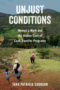 Tara Patricia Cookson, Unjust Conditions: Women’s Work and the Hidden Cost of Cash Transfer Programs (University of California Press, 2018)
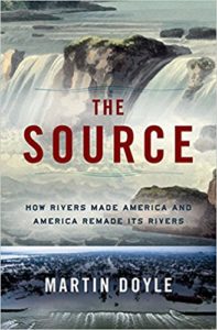 Martin Doyle, Duke University, The Source: How Rivers Made America and America Remade its Rivers (W.W. Norton, 2018)
 As I noted in my first presidential column, imagine what 12,000-plus geographers can do together to make a better world. We will be meeting in just two months in Washington, D.C. to share our ideas and to make a difference with Geography! Although the call for AAG annual meeting paper sessions and individual paper and poster abstracts is now closed, participants may still
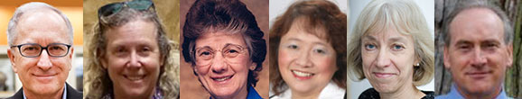
 Crystal King is a senior at Michigan State University, pursuing a B.S. in Economic Geography and a Cognate in Business. Crystal previously interned at a venture capital fund in New York City and hopes to combine her interests in business and geography by studying international business in the future. In her spare time, Crystal enjoys live music, a good book, and spending time with animals. She is originally from Detroit, but her favorite place to travel is London.

 As AAG President, Dr. Luzzadder-Beach, notes, recently we have marked the occasion of the containment of devastating fires in California and the publication of the Fourth National Assessment on climate change. In light of these events, she ends her column with hope, thanking those who have contributed abstracts to the AAG Annual Meeting and wishing everyone a “peaceful and rejuvenating holiday season.”
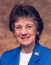
 The advice of a mentor can be instrumental in preparing young geographers for success in today’s competitive job market. The AAG seeks professional geographers representing the business, government, nonprofit and academic sectors to serve as volunteer Career Mentors during the 2019 AAG Annual Meeting in Washington, DC.
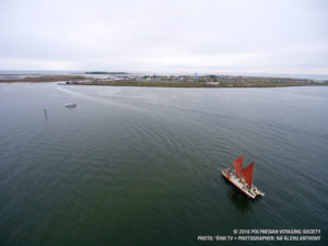 The Chesapeake Bay: Destruction and Rehabilitation in the Nation’s Largest Estuary
 In addition to the most recently published journal, read the latest issue of the other AAG journals online:
 This month, the list of new books includes books dealing with political subjects such as authoritarianism, populism, and fascism; manuscripts about Latin America; and texts with subjects as varied as bodies and sea otters. Skim the list to see if there are any of interest or consider reviewing them for the AAG Review of Books.
 Last month, Congressman and former high school geography teacher Tim Walz (D-MN) concluded a hard-fought campaign and was
  As an Environmental Consultant with Crouch Environmental Services, Inc., Amanda Sankey uses knowledge and skills from her geography degree to help development projects ensure that they are using the most sustainable practices available. More than that, Sankey talks about how geography is integral not only to her career, but her daily life as well in this month’s profile on professional geographers.
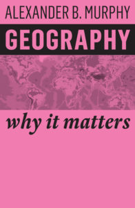 Order recent title
  The National Center for Research in Geography Education (NCRGE)’s Powerful Geography Initiative strives to improve awareness and appreciation of geography’s applicability to student preparation for life, work, and citizenship. One major goal of the study is to gather evidence of how geographic knowledge informs and enhances work and civic engagements in communities across the nation. The AAG invites professional geographers with an undergraduate or graduate geography degree who are working in all areas of business, government, nonprofit or academics to participate in this study.
 December 31st marks the deadline for multiple awards to honor and support geographers in all stages of their careers. Members may nominate their colleagues for the
 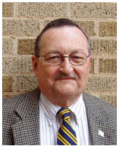 The AAG was saddened to hear of the passing of Otis W. Templar, Jr. on May 8, 2018 in his home city of Lubbock, Texas. The first permanent geography faculty hired at Texas Tech University in 1968, he went on to help found the department where he taught for over 45 years. Holding both a J.D. and a PhD, his research focused on arid lands and water law.


