Newsletter – July 2019
PRESIDENT’S COLUMN
Should we be worried? Or how to maintain and expand the number of geographers in our schools
By David Kaplan
 “As geographers, we all know the value of geography. Right? It is a field that provides a unique perspective, an appreciation for particularity, an opportunity to synthesize. But as much as we affirm geography’s value to each other, we also need to look at how geography is perceived outside of our community.”
ANNUAL MEETING
Prepare to register for #aagDENVER
 The 2020 AAG Annual Meeting takes place from April 6-10, 2020. Similar to the 2019 AAG Annual Meeting, registration rates will be based on the way in which attendees choose to participate in the conference. Please check your email in the coming days for an announcement regarding the 2020 Annual Meeting registration opening dates. And remember, register early for the best rates!
View the registration options.
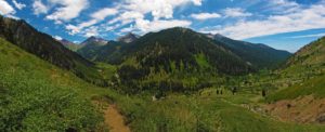
Denver, Colorado to host 2020 AAG Annual Meeting
Mark your calendar for the AAG Annual Meeting in the Mile High City April 6-10, 2020. Registration and the call for papers for #aagDENVER will be announced this summer. We look forward to seeing you in the Rocky Mountains!
- Decide which presentation type is right for you
- Book your hotel room in one of two hotels with an AAG attendee discounted rate
- Find out how to travel to meeting hotels by air or rail
- Suggest potential workshops or field trips by submitting a proposal
PUBLICATIONS
NEW Annals Issue Alert:
Articles with topics ranging from elephant-based labor and energy poverty, airspace to architecture
 The most recent issue of Annals of the American Association of Geographers has been published online (Volume 109, Issue 4, July 2019) with 16 new research articles on current geographic research. Topics in this issue include tornadoes, U.S. water insecurity, social vulnerability models, spaces of parenting, emotional geopolitics, historical geographies of the future, and effects of extreme weather on urban environments. Locational areas of interest include New York City neighborhoods, Ghana’s Offin River, Myanmar, North Dakota, and Chile. Authors are from a variety of research institutions including Dartmouth College, University of Manchester, Punjab University, and University of Connecticut.
All AAG members have full online access to all issues of the Annals through the Members Only page. In every issue, the editors choose one article to make freely available. In this issue you can read Plumbing Poverty: Mapping Hot Spots of Racial and Geographic Inequality in U.S. Household Water Insecurity by Shiloh Deitz and Katie Meeha for free for the next two months.
Questions about the Annals? Contact annals [at] aag [dot] org.
 In addition to the most recently published journal, read the latest issue of the other AAG journals online:
• Annals of the American Association of Geographers
• The Professional Geographer
• GeoHumanities
• The AAG Review of Books
New Books in Geography — April and May Available
 Read the latest titles in geography and related disciplines as found on the New Books in Geography list. Some of these books are chosen to be reviewed for the AAG Review of Books. If you are interested in reviewing any of the books found on the New Books list, please email AAG Review of Books editor Kent Mathewson at kentm [at] lsu [dot] edu. Please take note, the new books list will now be available exclusively on the AAG’s website.
Browse the April list or the May list of new books.
New issue of African Geographical Review
 The latest issue of the journal of the Africa Specialty Group of the AAG, the African Geographical Review, has recently been published. Volume 38, Issue 2 (June 2019) is available online for subscribers and members of the Africa Specialty Group. Each issue, the Editors choose one article to make freely available. In this issue you can read People, place, and animals: using disemplacement to identify invisible losses of conservation near Limpopo National Park, by Michael Strong for free.
ASSOCIATION NEWS
‘The Professional Geographer’ Welcomes New Editor
 Heejun Chang has assumed the role of editor for The Professional Geographer as of July 1, 2019. A professor and outgoing chair of the department of geography at Portland State University, Heejun seeks to use his experience in interdisciplinary publishing to encourage the submission of fresh ideas and diverse dialogues to the journal. The AAG thanks outgoing editor Barney Warf for his service to the journal over the past eight and a half years.
AAG Welcomes 2019 Summer Interns
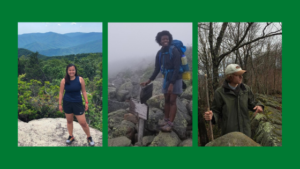
The AAG is excited to welcome three new interns coming aboard our staff for the Summer of 2019! Joining us this summer are Angela Yang, an incoming fourth year student at the University of Toronto majoring in Environmental Science and International Development Studies; Eni Awowale, a rising senior at the University of Maryland, College Park who is majoring in GIS with a concentration in Remote Sensing and also a minor in Astronomy; and Garrett Mogge who is a junior at the University of Maryland, College Park and is double majoring in geographical sciences and broadcast journalism with a minor in Spanish.
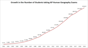
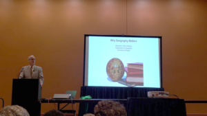
AAG Staff Participate in AP Human Geography Reading

Approximately 950 college professors and AP Human Geography high school teachers gathered June 1 to June 9 in Cincinnati, Ohio to evaluate essay exams from over 233,000 high school students. In addition to scoring exams, professional development activities were held such as a keynote from AAG Past President Alec Murphy and a presentation on AAG college and career resources from AAG social media and engagement coordinator Emily Fekete.
Read more about the AP Human Geography event.
POLICY UPDATE
House Approves Additional $10M for Geospatial Mapping to Address Water Quality, Hazard Resilience
 The AAG recently signed onto a statement in conjunction with MAPPS, NSGIC, and ACEC regarding an increase in FY20 Department of Interior funds to support enhanced 3D Elevation Program (3DEP) coverage of the Great Lakes region. This continued mapping work, managed by the U.S. Geological Service (USGS), will provide essential data for better understanding of the region’s most pressing areas of environmental concern. Since this statement’s release, the FY20 funding bill was passed on June 25th by the full House of Representatives as part of a five-bill appropriations package.
RESOURCES AND OPPORTUNITIES
Doug D. Nebert National Spatial Data Infrastructure Champion of the Year Award Seeks Nominations
![]() Nominations are being accepted for the Doug D. Nebert National Spatial Data Infrastructure (NSDI) Champion of the Year Award. The award will recognize an individual or a team representing Federal, State, Tribal, regional, and (or) local government, academia, or nonprofit and professional organization that has developed an outstanding, innovative, and operational tool, application, or service capability used by multiple organizations that furthers the vision of the NSDI. The deadline to submit nominations is August 15.
Nominations are being accepted for the Doug D. Nebert National Spatial Data Infrastructure (NSDI) Champion of the Year Award. The award will recognize an individual or a team representing Federal, State, Tribal, regional, and (or) local government, academia, or nonprofit and professional organization that has developed an outstanding, innovative, and operational tool, application, or service capability used by multiple organizations that furthers the vision of the NSDI. The deadline to submit nominations is August 15.
More information about the award.
Internships at the AAG
The AAG seeks interns on a year-round basis for the spring, summer, and fall semesters. Interns participate in most AAG programs and projects such as education, outreach, research, website, publications, or the Annual Meeting. A monthly stipend of $500 is provided and interns are expected to make their own housing and related logistical arrangements. Enrollment in a Geography or closely related program is preferred but not a prerequisite for these opportunities. Applicants should forward a resume, brief writing sample, and three references to Candida Mannozzi.
More information about internships.
GEOGRAPHERS IN THE NEWS
- Recent research by Maxwell Hartt of Cardiff University on economic prosperity in shrinking US cities profiled in City Lab
- Geographers Noam Leshem and Alasdair Pinkerton create Google Arts project on geographies of 21st century forbidden zones across the globe
EVENTS CALENDAR
 The AAG is pleased to announce the release of a
 ![Graph 1: AAG Minority Membership since 1981.[6]](https://www.aag.org/wp-content/uploads/2021/11/AAG-minority-membership-640x332-1-300x156.png)

 The thing is, the GIS community has been using AI for a very long time. Performing regression, kriging, clustering, hot-spot analysis—these capabilities have been adopted into a subfield of AI called machine learning. Machine learning, at its core, is composed of approaches that learn from data rather than being explicitly programmed. Machine learning has been changing the world for decades, though it’s only recently that the public has started to become aware. This is mostly due to the emergence of deep learning.
 We’re getting closer to the 2019 AAG Annual Meeting! Whether you will be attending the meeting all week, for a few days, or looking to follow the action from afar, there are plenty of ways to get involved using social media. Social media is a great way for seasoned conference goers and newcomers alike to network, report on new research, engage in lively debate with those inside and outside of the discipline, and find out what’s going on during the largest geography conference in the world! Start planning your #aagDC social media strategy today with these helpful guidelines!