The Advancement of Location Analytics in Business Schools

by Joseph Kerski
Education Manager, Esri, and Instructor, University of Denver

A quiet geographic revolution is occurring on many university and college campuses around the world. Faculty and students in schools and colleges of business are increasingly turning to GIS tools and data in instruction and research. Given that business has always been about “location, location, location,” it makes sense that educators seeking to prepare their students for the workplace are doing so. Yet location analytics, as it is most often called in business schools, took some years to gain a firm foothold. Why is this the case, what are the implications, and how can the geography community assist with these exciting developments?

Business schools adopt geospatial tools and datasets for the same reasons that faculty in disciplines such as geography, health, and data science do so: instructors want students to learn skills in critical thinking, spatial thinking, and problem-solving; to find tools that can help them link theory and practice; to guide students to be effective decision-makers and leaders when they graduate into the workplace; and to see patterns, relationships, and trends in the data they analyze for their own research. Location analytics is most commonly taught in supply chain management, risk assessment, marketing, consumer behavior, and management courses. This article highlights five shining examples of exciting developments happening right now, ranging from individual courses to complete programs in business analytics.

In this location analytics activity are enriched tessellations using ArcGIS Business Analyst Web App showing the number of adults carrying medical insurance.

Several developments have been key to ushering in the adoption of location analytics:

  • As GIS tools migrated to a cloud-based, software-as-a-service (SaaS) environment—manifested in such tools as ArcGIS Insights, ArcGIS Online, and Business Analyst Web App—they became much more straightforward for instructors to incorporate into their courses. The tools have become easier to use and no software needs to be installed.
  • Data on business locations, suppliers, demographic characteristics, and consumer preferences has become available for multiple countries and often at very detailed geographic units (in some instances, down to the neighborhood scale).
  • There is recognition that GIS can help users analyze patterns, relationships, and trends as well as assist businesses to meet the needs of their customers and reach their sustainability and societal goals. Businesses exist to add value. Location is vital to all aspects of business and adds value to it. The world of business is in a state of continual change. Location analytics enables businesses not only to manage current operations but also to plan for and enable change.
  • There is a growing trend toward enabling students to be proficient in today’s “big data” world. This is partly why some universities are creating data science programs, which often are coupled with business programs.
  • Seeking to place graduates in meaningful careers, colleges and universities view location analytics skills as enhancing a graduate’s value to a current or future employer.
  • Business schools, by their very nature, are competitive. They see that adding location analytics courses and programs helps their university stand out and attract students.

For more about these and other developments, see the article Introducing Business School Students to Location Analytics.

Why should the geography community care about these developments? Consider the thousands of students graduating each year with bachelor’s and master’s degrees in business from hundreds of universities around the world. Think of these graduates’ influence in society. Imagine a world where decisions in the business world are routinely made by people who have applied geographic thinking to solve problems—people who began their geospatial journey while they were students. Within academia, business students and faculty keen on the application of location-based data and tools can be strong allies for your own geography department and initiatives.

Despite the adoption of the use of GIS in business programs, much work needs to be done. Many faculty members in business are still not aware of the value that applied geography brings to their programs, nor do they know how to use GIS. They may think that GIS is just for the geography department and is not applicable to their own work. Using any professional-level tool such as GIS presents a double challenge: faculty must at least be comfortable enough with the tools to use them in their courses, and they must understand how to effectively teach with them. Location analytics is part of a system—a geographic information system—that contains many interlocking components. Deciding which of the components to use in teaching, and in what manner to do, so takes effort.

This is a key time to work with your business schools. The disruptions to business and society caused by COVID-19 can be understood and mitigated through using geographic thinking and applying geospatial tools. The spread of disease, the actions taken to limit the spread, the disruptions in supply chains, the choices of how and when to reopen public spaces and university campuses, and a score of other relevant and current issues are rooted in geography. Businesses and business schools are more receptive than ever to tools that will help them deal with the disruptions, and geographers can help their business school colleagues learn to use these tools effectively.

With your grounding in geographic theory and practice, you—the geography community—could be of enormous help to business students and faculty. To assist you in this effort, see the Location Analytics in Business Education landing page, which includes location analytics tools to use in courses; ways to learn how to use these tools; and learning pathways, spatial data, curricular materials, case studies, and success stories. Key messages and a workshop syllabus are included and might be useful as you work with these colleagues. Such collaborative efforts could also provide you with resources and perspectives that you could incorporate into your own courses.

    Share

Joanna Thompson-Anselm

Education: Honours B.A. in Geography and Urban Studies (York University), Bachelor of Education (York University)

Describe your job. What are some of the most important tasks or duties for which you are responsible?
My job as subject head is to ensure quality geography programming for all students in our building and to mentor staff to develop their own professional geography knowledge to stay current with pedagogical demands and content.  I work with staff and students to determine what current geographic issues are of interest and important to them and then help develop a program that is responsive to those interests.  It is really important that we are continually reviewing geotechnology’s part in helping us inquire more deeply about geographic issues, but also transferrable and other geography-specific skills that are needed for students to be employable in the 21st century.  To create a robust program that serves the whole student, this requires ongoing professional development both in teaching and learning strategies as well as current trends in geography.

What attracted you to this career path?
I have always known that I wanted to be a teacher, but I didn’t know that I wanted to be a geography teacher until I met my high school geography teacher, Mr. Meikle.  The way that he engaged us in anecdotes, case studies and simulations that made me realize that my passion was really about understanding why people and things are different in different parts of the world.  I am inspired daily to work with staff to come up with engaging ways to have students learn important skills, but at the same time have fun and be excited to ask more questions about the world they live in.  As value in our subject area has been dwindling in my community over the past few years, I’m more impassioned than ever to work on creating relevant and meaningful geography tasks for the students I work with.  Students and parents need to understand that geography brings together all other disciplines and includes very employable skills in a globalized world.   As Michael Palin, past president of the Royal Geographical Society, has remarked: “Geography explains the past, illuminates the present, and prepares us for the future.  What could be more important than that?”

With regards to working as a course writer for Queen’s University, this is the newest chapter of my life. I’ve chosen to explore this in order to help people find their own passion to develop quality geography programming in our schools.  I believe that in order for geography to be more recognized as a valuable subject area, it should be taught by teachers who are inspired to look at it in new and different ways. My goal is to develop a culture of creative and critical educators who will engage their students in meaningful work that will make an impact on their communities.  I want to encourage teachers to try something new that will allow their students to explore and be challenged by geography content and skills.

How has your education/background in geography prepared you for this position?
My degrees in geography and education have given me the credentials to teach geography in Ontario, but most of my education has been on the job and through professional development offered through the York Region District School Board or OAGEE (Ontario Association of Geographic and Environmental Educators) and through the networks I have created for myself.  In our discipline, content is changing daily and approaches to teaching are changing equally rapidly in response to technological development, student engagement and workforce demands.  Continually trying to find ways to showcase that geography teachers are relevant is an ongoing educational and marketing experience!  I have recently presented on gamification in the classroom to a group of educators at the IDEAS Conference at the University of Calgary, but the learning of gamification came from professional reading and collaborating with colleagues.  The learning and education of a geography teacher never ends!

What geographic skills and information do you use most often in your work? What general skills and information do you use most often?
These days I find myself using a lot of spatial analysis skills to come up with my tasks and hooks for students and to help them dig more deeply into their own geographic inquiries.  For example, the ability to use spatial skills to interpret a thematic map or analyze an aerial photo to see if a location contains the features I am looking for to develop a task to engage my students is critical.  The geography teachers in our department often look at spatial data to ask or answer questions about content we are working on, and sometimes we look at it together and are excited by the information we have found that we can now share with students!  We often use our geographic thinking concepts of interrelationships, spatial significance, pattern and trend and geographic perspective to help students see the complexity of geographic problems and how they are interconnected with other subjects like science, business and urban planning.

One important general skill I use on a daily basis is communication, which I use in a variety of contexts from discussing programming needs with our administrators, to teaching students about the applications of geotechnology, to speaking with parents about student progress and needs.  Data management and critical thinking skills are also essential when organizing groups of students, plotting curriculum standards into themes for student learning and scaffolding that learning for best success.  Lastly, I routinely use the skill of time management – forgotten by many of us!  With all the responsibilities that come along with my job, it’s important that I make agendas, checklists and review my goals for work, home and recreation to keep a balanced life.

Are there any skills or information you need for your work that you did not obtain through your academic training? If so, how/where did you obtain them?
My geography/urban studies degree mainly focused around human geography, urban dynamics and some physical geography foundations.  Cartography was not a mandatory course, so I left university without much learning about GIS.  Now I feel that it is my duty to be informed about various geotechnologies, specifically public domain ones, so that I can build a more relevant and accessible program that develops employable skills in my students.  Google Tourbuilder, Timelapse, Earth, and Maps have all been useful platforms for which I’ve had to learn the capabilities to be able to instruct my students directly or pair them with a problem solving task.

Do you participate in hiring, screening, or training of new employees? If so, what qualities and/or skills do you look for?
In the public education system, subject heads are not allowed to be involved in the hiring process.  However, once teachers have been hired and assigned to our department, it is then my job to mentor them and offer professional development opportunities.  I really value teachers who have a sense of excitement about geography and a drive to be creative in their activity planning, assessments and lesson delivery.  It is always exciting to work with someone who is equally invested and interested in taking risks in the classroom with their program delivery.  They don’t even have to be geography teachers, just people who are willing to learn, refine, collaborate and take risks to improve student learning experiences in geography.  I also value working with teachers who have strengths that complement my own.  For example, it is a huge asset to have someone who is more proficient than I am in geotechnology and Google Apps so that I can learn from them in building my own competencies.

What advice would you give to someone interested in a job like yours?
I would highly suggest seeking mentorship from an in-service geography teacher who knows how to network, find resources, is well connected with outside organizations and loves their job.  These are the qualities of a person who will be able to give you sound advice and encourage you to become the teacher you want to be.  I would also suggest taking pedagogical risks in the classroom and exercising your creativity.  Work ethic and creativity are also things that can really set people apart.

What is the occupational outlook for career opportunities in your field/organization, esp. for geographers?
It is difficult to say what the career opportunities look like for geographers in terms of being a geography teacher or instructional leader, as so much of it has to do with the particular school board.  In the Toronto District School Board they have subscribed to the model of “super heads” in which an instructional leader is responsible for supporting curricula from multiple subject areas.  In my school board, geography subject heads are still distinctive, but there is growing concern about how long we can stay that way without being amalgamated into a “social studies” subject head that would include other departments.

As for being a geography teacher, I believe that the future is bright.  The headlines everyday speak to global issues such as those associated with climate change, genocide, globalization, and geopolitics.  People are beginning to recognize the importance of geographers in helping to bring together all of the pieces from different disciplines in order to help solve these complex problems.  I hope I can play an important role in that!

    Share

Ethical Research in the Age of COVID-19: A Participatory Forum

Introduction

AAG assembled the following perspectives from the discussions during the AAG Participatory Forum on New Requirements for Ethical Geographic Science in Rapid Research held October 1st, 2020.

We worked with AAAS’s Science and Human Rights Coalition to experiment with a format that could help us overcome the lack of face-to-face exchanges and networking. We all miss face-to-face meetings, but these important conversations and collaborations on ethics can not wait!

During the participatory forum, no panel of experts was asked to prepare carefully rehearsed presentations, instead, forum moderators were invited to guide discussions on specific questions among small groups of participants. The format creates more opportunities for exchange among the students, professors, and professional scientists who attend. Moderators continued these discussions during the AAAS Science, Technology and Human Rights Conference 2020, opening these questions to scientific disciplines beyond geography, which increasingly rely on locational information. In this series, moderators are reporting back on the discussion they guided at these virtual venues.

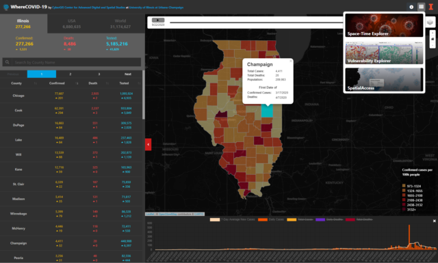
This Participatory Forum extends conversations that started at AAG’s Virtual Annual Meeting, April 6-10, 2020, during public panels of the breaking theme “Geographers Respond to COVID-19.” That series, held during the very first months of the pandemic, raised important, high-stakes questions of ethics and human rights, which were documented in a written summer series on the event.

These efforts have been supported in part by the AAAS Science and Human Rights Coalition, of which the AAG is a founding member.

Lessons from the Pandemic: How Can We Put People First in Emergent Research?

Andrew Curley, Sara Koopman, Libby Lunstrum, Diana Ojeda, Lisa Schamess

The COVID-19 pandemic has raised profound questions of research ethics within geography. One of the most vexing is how to foster genuine research partnerships beyond mere participation so that people impacted by the phenomena under investigation are truly part of the conversation and of the search for solutions.

Hurdles for building respectful, collaborative research begin with the structure and intent of many funding opportunities, with their short deadlines and focus on quickly understanding and addressing COVID-19. While we share in the sense of urgency in needing to gain insight and develop solutions to address this public health crisis, the intensity of timelines and expectations for quick turnarounds can hamper meaningful collaboration and even harm longstanding relationships that are often built on trust and follow a slower pace more conducive to genuine relationship building. This context of urgency is also conducive to extractive, colonial modes of top-down “in-and-out” research that devalue input from the communities the research seeks to understand, aside from what can be most expediently gained. The resulting research produces rather than coproduces understanding and, because of this, leads to questionable findings. This becomes even more ethically vexing when there is an implicit or explicit connection to profit or when communities are primarily viewed as “test populations,” as when pharmaceutical companies partner with university researchers in the search for a cure to COVID-19.

COVID-19 has also opened new modes of engagement with research partners, as many of us have been forced to conduct “fieldwork” like interviews, focus groups, surveys, and workshops over Zoom and other online platforms. This shift to online research raises profound ethical questions that begin with difficulties of gaining consent. In many cultural contexts, genuine consent requires in-person conversation and relationship building. Other ethical minefields of online research platforms include the ability of the researcher to record meetings without participants’ knowledge, the ease of hacking platforms like Zoom, possibilities for state surveillance, related difficulties of maintaining anonymity, and broader questions concerning the cultural appropriateness of these more distant forms of encounter that extend beyond issues of consent. In addition, if engagement goes online, this can once again lead to top-down forms of engagement where community or other leaders represent the interests of others who may not have adequate internet bandwidth or cellphone data. This leads to ethical concerns around representation, including whether more vulnerable people impacted by COVID-19 are part of the conversation on how best to address it. In short, use of online technologies to replace in-person encounters requires even more stringent attention to power relationships and ethical responsibilities on behalf of the researcher.

Benefits of the New Normal, and a New Role for Researchers

Despite these concerns, the use of online research tools also offers important opportunities. In addition to allowing us to stay in contact with research partners and even forge new relationships in the context of a pandemic, these tools allow for networking, relationship building, and research in ways that have a smaller carbon footprint, lessening our contribution to climate change. New technologies may also make it possible to forge partnerships in a context of scarce research funding. In addition, we must recognize that meeting digitally can save lives. Universities are prime sites of virus transmission, and hence meeting digitally, even when our partners are local, protects our research partners by preventing virus transmission.

COVID-19 demands new obligations of researchers, given our privileged roles in universities and other institutions of knowledge production. We are in a position to call out interventions that have happened too quickly with little regard for groups that will be most impacted. We see this, for instance, in hastily implemented, overly harsh COVID-19 restrictions that target already vulnerable and exploited groups. These range from militarized restrictions targeting racialized urban residents seen as “prime vectors” spreading the virus, to interventions into the lives of rural communities involved in the wildlife trade whose practices are seen as creating new pathways for zoonotic disease emergence. As researchers and advocates, we have an urgent ethical responsibility to call out inequitable practices authorized by crisis narratives and related dynamics.

Notwithstanding the devastation COVID-19 has brought, the pandemic provides an opportunity to pause in the face of the fast-paced research environment that characterizes an increasingly competitive and neoliberal university. As a welcome response, many universities have added time to tenure clocks to protect pre-tenure faculty. But more can be done. The pandemic provides an opportunity to welcome a slower pace of relationship-building, research, and publication, reinforcing the insights of the “slow scholarship movement,” and returning to core values of what motivates ethical research and the relationships upon which it is built. Slowing down also allows for recognition of the gendered and racialized impact of the virus on us as researchers and teachers, especially as women and racialized groups are responsible for a disproportionate amount of family and community care. In addition, slowing down enables researcher self-care and focus on our mental health, as we are not just researchers but partners, caregivers for our children and elders, and members of our own communities. This points to an additional danger of digital research technologies, in that they may convey a sense that “business as usual” can proceed, when the pandemic provides a needed opportunity to reflect on how unsustainable aspects of pre-COVID work were in the first place.

More than Just a Face: Human subjects in a Time of Geospatial Tracking and Recognition

Junghwan Kim (University of Illinois at Urbana-Champaign)*

GIScience methods and technologies now enable researchers to collect and analyze highly detailed location information of human subjects (e.g., daily GPS trajectories). Our discussion acknowledged that, along with the benefits of using these new technologies, comes the potential threat of violating geoprivacy. This raises new ethical issues, especially when more invasive new technologies, such as drones, automated location tracking tools, and facial recognition tools (with artificial intelligence) are also used for research purposes. For example, to understand people’s emotions in public spaces, researchers may utilize a camera installed in drone and facial recognition technologies to capture people’s emotions revealed in their faces. However, without proper consent from research participants, the collection of data may seriously breach people’s geoprivacy. Since these technologies are new to us, we may need to critically examine and assess the potential risks of geoprivacy violations related to the new technologies.

Moreover, it is especially challenging to protect the geoprivacy of research participants during the unprecedented COVID-19 pandemic. During the pandemic, some countries have adopted COVID-19 mitigation measures that use information about people’s private location (e.g., digital contact tracing). Although these measures may critically violate people’s geoprivacy, less attention has been paid to the protection of geoprivacy in the name of controlling the pandemic. Under these circumstances, it is important to wisely balance public health and geoprivacy protection. In parallel to such concerns in the public policy, researchers are also subject to pressure to overlook the importance of “geoprivacy protection” at a time when more knowledge about COVID-19 is urgently needed. In this light, our group discussed the need for more attention to be paid to protecting privacy while implementing COVID-19 policies and conducting research.

We also agreed that we should continue our conversation in a context similar to the AAG/AAAS online forum, to enhance the awareness of geoprivacy and related important ethical issues, not only in the community of geographers, but also other scientists at large, including IRB personnel. Although geoprivacy is one of the important issues that has been widely studied in the field of geography, the group agrees that there is still a long way to go. For example, some researchers, particularly those outside of the geospatial disciplines, might not even be familiar with the concept of geoprivacy, and might need to be made more aware of the pitfalls. Otherwise, research participant’s privacy might be critically violated through spatial reverse engineering, for instance, even if a map does not explicitly illustrate their specific identity (e.g., name and street). This is particularly important as interdisciplinary research that uses sensitive geospatial information is being widely conducted. Therefore, the group discussed that more efforts are urgently needed to promote the awareness of geoprivacy issues among researchers.

* The moderator greatly appreciates the participants’ invaluable time and input during the discussion.

Safeguarding Confidentiality in GeoSpatial Research

Ranu Basu

How should scholars safeguard confidentiality of human subjects in research, when we know that re-identification of anonymized data is sometimes possible, and when geographic representation (or interpretation) is often flawed?

The concern for protecting human subjects’ confidentiality is especially compelling because of the uneven power relations that are involved in the production of knowledge and its implications for marginalized and displaced communities (i.e. racialized, gendered, forced migrant, indigenous, and precarious labor). These concerns are amplified when handling large data sets, including when researchers use mapping without due consideration to ethical guidelines. The concerns raised in our group included the need to contextualize these guidelines: from the often limited incorporation of the historical or political contexts of communities; recognizing the continuing legacies of colonialism and imperialism including the contested geopolitics of borders and territoriality; to questioning the underlying socio-spatial processes leading to uneven development at all levels. Geospatial technical concerns and confidentiality of data were discussed in relation to these contexts regarding errors in the representation of spatial data; fast-mapping; aggregation techniques (MAUP) and use of suppressed data; the politics of categorization and spatial orderings; power imbalances of conducting research involving vulnerable communities and developing true participatory research. Geographers offer valuable insights and guidelines in approaching such challenges through the integral linkage of critical theory with geographic methods.

A number of questions were raised to facilitate discussion: Whose confidentiality is at stake?; How is confidentiality compromised?; What could be the possible repercussions?; How might geographic representation be flawed?; What challenges has COVID-19 further posed to these issues?; and What perspectives and unique insights can geographers offer? Based on their research in the field and inter-disciplinary insights, the participants discussed the various complexities related to privacy and confidentiality, ethical dilemmas, the technicalities and nuances of geospatial approaches, conducting research online, institutional processes, and various participatory models as ways to avoid reproducing power differentials.

Some highlights during the discussion included:

The ethics of interviewing displaced and non-status migrants, particularly those vulnerable to deportation. It remains important to reduce the risks of re-identification of anonymized data alongside legal status, ethnic tensions, and inequities that surround Indigenous and racialized populations.

The process and uncertainties of acquiring institutional approval during a time of COVID-19, especially with changing realities and resources for ensuring anonymity across the virtual communication platforms we increasingly rely on, and which carry their own risks with regard to confidentiality.

Contradictions unravel between trying to conduct research safely during COVID-19 while at the same time ensuring privacy. While Zoom interactions and video calls have become a central method for holding distanced meetings, there are difficulties in maintaining descriptive information private. Additionally, if translators and transcribers are needed, meetings must be recorded and shared.

Conducting research online can have an impact on subjects’ spatial experiences of their privacy and comfort, which might deter individuals from participating in studies. Accessibility is also a concern, along with the inherent digital divide that already impacts marginalized people’s ability to participate in civic, educational, and economic opportunities, including their ability to participate in potentially beneficial research and to be heard in the results.

Alternative applications and encrypted programs were discussed, to prevent data mining, along with blurring of faces or deletion of names of participants in video calls in efforts to secure anonymity. The reliance on internet and third-party access to data for most programs poses barriers to full anonymity, particularly with regards to who is included and who is left out of the research process.

As data mining becomes more sophisticated, re-identification becomes more likely. Although big data continues to be sought after, the ethics of its applications are not always considered, particularly in the movement of data to online collections. This can put researchers at odds with the institutions that seek out or provide their data, as the institutions seek bigger and better datasets, while the researchers seek to protect their subjects’ privacy and the integrity of their results.

With the wide proliferation of maps, there are also flawed interpretations and representations which consequently create false depictions that in some cases can lead to communities being stigmatized, criminalized, and further excluded. Further, colonial histories related to the mapping of territorial rights, contested borders and occupied spaces often remain unaddressed. The technicalities related to these conundrums were discussed – whether addressing the modifiable area unit problem, errors associated with aggregation of data, the sources of digitized data, missing data.

The focus on volunteer geo-information in applications poses ethical issues: people are not always aware of how their data will be used for other issues. In a time of COVID-19, as data is increasingly being called upon to navigate fast-paced scientific inquiry, the barriers to safeguard data are lower. While many geographers are aware of geo-privacy issues, other researchers, and policy makers, are not. It is therefore important to continue raising these issues in contemporary frameworks and to thoroughly (re)think and rebalance the need for locational data with the need for privacy in an ethical research process.

Geographers can help raise awareness of geo-privacy, not yet a well-known concept. It would be helpful to continue questioning the practices involved in geo-privacy with researchers, provide guidelines for ethics and mapping to institutions, and further these debates in the classroom.

Lastly, geographers might lead toward creating a balanced approach to maintaining anonymized spaces and identities, in the interest of safeguarding confidentiality, while also listening and giving voice to a wide range of perspectives in these spaces.

Who are the human subjects or places in research and, who is benefitting from rapid Geospatial COVID-19 findings?

Sheryl Luzzadder-Beach, on behalf of AAG and AAAS SHR Forum Participants

Participants in this breakout conversation considered the perspective of what insights their disciplines (Geography, Chemistry, Sociology, Statistics, Health Sciences, Science Writing, Physics… etc.) bring to two questions on Geoethics and Rapid COVID-19 Research:

  1. Who is carrying the burden of rapid Geospatial COVID-19 science (who are the human subjects or places in research); and, who is benefitting from rapid Geospatial COVID-19 findings?
  2. Who is carrying the burden of COVID-19 Geospatial science (who are the human subjects or places in research)?

The Science and Human Rights Framework (UNHRC Article 15, The Right to Benefit from Science) was an underlying focus to our breakout conversations:

  • How science can help Human Rights,
  • How science may hinder Human Rights.
  • How to help scientists’ Human Rights in these situations.

Discussions with AAG members and with AAAS members highlighted a number of concerns for human subjects and places. First, producers of knowledge bear a burden through the risk of acquiring and transmitting a deadly disease through place-based research. People seeking knowledge, and asking for rights and change can be intimidated by authoritarian regimes, who can use regions to clamp down on protests, or can shut down the voices of scientists attempting to share information. What Geographers bring to the table is the ability to use spatial knowledge to convey the geographic, temporal and intensity distributions of a pandemic, to inform the public. This relies on public health officials who bear the burden of rapid and accurate reporting of results. Risks are run in the human subjects research arena of the need for rapid IRB approvals for research, and care must be taken to protect not only vulnerable individuals, but also vulnerable geographical populations, whether it is at the neighborhood level, or community level, so that they are not discriminated against, and they receive the resources needed (COVID testing, medical care, personal protective equipment). The groups suggested that IRB protocols need to be expanded and updated to consider the urgent global proportion and timeliness of rapid response to a pandemic.

The need for rapid peer review was also seen as a pressure point on publishers and scholars alike, for rapid research and validation of results in this deadly topic. Frontline medical researchers are dependent on other sciences in important ways. For example, the burden of research about the nature of airborne particles and the effectiveness of masks is dependent on research carried out by physicists to test the lingering behavior of aerosols, and how masks do or do not screen this, which is a dimension of research beyond medicine, but complementary and necessary. Science itself has a burden of building trust in a political climate of skepticism, and the politicisation of science. The natural sciences, biosciences, and medical sciences are seen as the first line of bearing the burden of research, a cause for concern among Social Scientists and the Humanities in the competition for funding in the time of COVID-19. However, the Humanities and Social Sciences bear an important burden of providing models of human behavior to assist in understanding the vectors of the spread of COVID, and the differential impacts on communities based on the resources they may or may not have. This is amid fears that the shift in funding for research in general has focussed on the hard sciences and medical sciences, and whether the research is of direct benefit to COVID or not. The public also bears a burden, including opting in for the greater good into COVID notification tracking programs on mobile devices, which link back to COVID geographies. More broadly, Adults bear much of the burden of testing and of clinical trials of vaccines to come. Then, linking COVID data to geographies when you get to smaller neighborhoods encounters the same privacy issues as census data, as discussed above. Do the conversations around reporting geographic data for COVID-19 and for racial and ethnic data overlap? It can link neighborhoods to certain ethnic groups. But also it can show that certain neighborhoods have reduced access to healthcare and other resources. As global citizens, we are all burdened in how we navigate life during COVID-19 and protect the greater society through our own actions and choices.

On the individual level, adults benefit from being able to consent to and participate in trials of COVID-19 testing and vaccines, and consent to the use of tracking devices. Children and other vulnerable populations do not have this benefit. And the question arose, can children even consent to tracking? Children are the last to benefit, and have suffered in so many ways from the politicization of school attendance versus online schooling. On a larger scale, Big business including big Pharma, online businesses, and delivery services have benefitted overall, but as focussed sectors of an otherwise depressed global economy. The ethical concern is how those who benefit move forward and think about the future of research based on how we define the broader impacts of our work, whether in geography or other fields. The medical and pharmaceutical industries who focus on COVID-19, in lieu of other lifesaving research, also stand to benefit in the short term. Beyond academia, the developed world benefits due to a collectively higher standard of living and access to resources, but in the developing world, fellow citizens struggle to earn enough money for lunch each day, making personal sacrifices to earn those wages. The privilege of staying home places big blinders on the everyday effects on other people where earning a livelihood is a daily affair.

DOI: 10.14433/2017.0081

    Share

Vote for Geography

No matter what happens with this week’s election, the United States will pivot.

Four years ago, most people in my life expressed horror, shock, and disgust following the presidential election in the United States. The day after the election, I shared with my husband my apprehensive relief following the results. I’ll explain.

I grew-up in Atlanta. Looking back, it seems that I may never again live in a place with such diversity. I spent my primary, secondary, and post-secondary school life living in a world of open sexism and racism. Then I moved, first to East Lansing, Michigan and then to Eugene, Oregon. My children mostly grew-up in Eugene. While beautiful, I often say that my biggest parenting regret has been raising my children in a loaf of Wonder Bread—white, white, white—slice after homogeneous slice.

I realized that once out of the south, sexism and racism still exist. They’re just packaged differently. Their insidiousness is delivered with smiles and well-meaning comments. I have had different versions of this conversation many times:

Person: “Oh, you’re from the south. They’re so racist down there.”

Amy: “Yes. But, there’s racism here too.”

Person (a counter argument, usually centered around a sentiment like): “How can we be racist when there aren’t many Black people here” or, “I am color blind in my beliefs.”

How indeed can we participate in “-isms if our gut, our heart tells us we are not that way? Remember Stephen Colbert’s “truthiness”? Try googling it if you do not.

That’s when I realized that the most sneaky and powerful form of racism…the one that perpetuates it…is the one that refuses to be acknowledged: the denied racism.

I’ve heard some people argue that the reason behind denied racism, denied sexism, denied ableism, and denied other-isms is as simple as not having the lived experience. Maybe Harper Lee sums it up well: “You never really understand a person until you consider things from his point of view.” (Atticus to Scout in To Kill a Mockingbird).

My proposition for the real reason behind denied bias is less merciful. The denial of racism, just like the denial of sexism, ableism, and any other “-ism” is what gives those biases their core strength. We know that denial is not merely human nature. In fact, the human brain uses denial as a way of helping us process difficult truths, such as when we experience a traumatic event. We are literally programmed to use denial as a tool to protect ourselves from the reality that is happening in our lives.

Denial of existing biases is about identity. Denial allows us to look away from reality and see what we need to see. We use denial so that we don’t feel bad about our own identify, our self-respect, our global understanding, and our society. Confronting such deeply-entrenched denial requires something extraordinarily powerful to happen.

So, thinking that the election results may be the extraordinarily powerful event to wake people from their denied-bias slumber, I experienced apprehensive relief following the 2016 election. Relief because the election would reveal, finally, how broadly and deeply rooted many forms of bias are in America. Apprehensive because pulling off that big ugly bandage would uncover a festering and extremely painful wound.

Four years later, it is now critical to ensure that another denial doesn’t take hold—the denial of root causes and our responsibility.

There are so many specific events over the past four years for which we can be angry with current leadership: hideous comments about women, refusal to condemn white supremacy, overtly racist practices, publicly mocking people with disabilities…there have been so many atrocious acts these past four years that it’s impossible to provide a complete list. But…

I believe that anger at leadership for causing these rifts is largely misplaced. Our current leadership did not create the painful wounds of bias: racism, sexism, ableism…fill-in-the-blank-ism. Rather, our current leadership simply reflects America’s long-standing EverythingOtherThanAbleBodiedWhiteMale-ism. Leadership merely gives voice to a widely accepted set of beliefs based in collective biases.

It is those shared biases that deserve our introspection and disgust.

In moving forward, the emotional healing process includes four to seven stages, depending on whom you ask. Regardless of the source, stages present in a sequence similar to this: 1) Denial, 2) Anger/Expression, 3) Reflection, 4) Transformation, and 5) Corrective Experiences.

Our current leadership has been very effective in starting the process to move us out of Stage 1 and into Stage 2. And, now his work is done. We need a new form of leadership to continue. The next Stages are harder. We held on to and denied our biases for too long to think that they will magically transform to Corrective Experiences. For those difficult Stages, we need leadership that demonstrates decency, maturity, integrity, grace, strength, and empathy.

We need leadership who understands that we cannot stay in the Stage of Anger/Expression without causing new wounds. We also need leadership that understands interconnectedness of social foundations, and that moving toward Corrective Experiences has to happen through strong societal infrastructure.

But that is not all. Just as compelling (especially for geography) is the need to vote for science. In the past four years, science has experienced a marked uptick in interference, contempt, dismantling of research data, personal attacks, and an overall assault on validity of scientific research from our leadership. Much of the American public has followed.

Now, read that paragraph once more and substitute “education” for “science.”

Again, leaders don’t create EverythingOtherThanAbleBodiedWhiteMale-ism. Rather it’s the persistent existence of -isms that creates leaders who mirror those biases. Voters choose leaders who best represent their beliefs. In response to outcries of racism- and sexism-motivated voting in the last election, how often did you hear angry, defensive words such as “I voted for leadership because of x,y,z policy. I don’t support their sexist, racist, ableist views.”

Bullshit.

Acceptance of sexism IS sexism. Acceptance of racism IS racism. Acceptance of ableism IS ableism. And…voting for a sexist is sexism. Voting for a racist is racism. Voting for an ableist is ableism.

So, regardless of the outcome of this election, we will pivot—backward or forward.

The bandage has already been yanked off. We don’t need to go back.

I plan to…Vote for science. Vote for education. Vote for decency, empathy, grace and intelligence. Vote for geography.

—Amy Lobben
AAG President and Professor at University of Oregon
lobben [at] uoregon [dot] edu

DOI: 10.14433/2017.0080


Please note: The ideas expressed in the AAG President’s column are not necessarily the views of the AAG as a whole. This column is traditionally a space in which the president may talk about their views or focus during their tenure as president of AAG, or spotlight their areas of professional work. Please feel free to email the president directly at lobben [at] uoregon [dot] edu to enable a constructive discussion.

    Share

Resilience in GIS Education

COVID-19 Cases across the United States.

Bang. The spring semester was cut short, everyone was sent home, and the fall semester is still morphing. The COVID-19 pandemic has caused a reset in the way we think about teaching and learning. Distance learning is not new, of course, but forced distance learning on a global scale—that’s a different story. This causes disruption and tension in all disciplines but is more acutely felt in disciplines that are dependent on hardware laboratories, as in the case of GIS. Can we–educators and learners—adapt? Are we resilient? And will we be resilient when the next unannounced disruption occurs?

During August 2020, the University Consortium on Geographic Information Science (UCGIS) began a series of online panel sessions entitled Resilience in GIScience Education. During the preliminaries, the group quickly agreed on a very wide view of resilience, defining it as the overall ability to cope with and adapt to disruption. Because the first round of panels was focused on pedagogy, I made what I feel is another important clarification. The title of the session series (as well as “UCGIS”) deliberately refers to geographic information science (GIScience), not GIS per se, although many people will conflate them. But it seems useful to clarify whether any one of us is really talking about educating geographic information scientists (which is normally done at the graduate school level), or whether we’re talking about educating undergrads about the hows and whys of GIS. One learner may be planning to go on to a research career; another may want to graduate ASAP and go to work for a GIS company or government agency. One curriculum would normally focus on theory and methods (David Mark, 2003), the other on practice and problem solving. Student profiles and expectations are important to consider here.

There were some other fundamental questions as well. Is COVID-19 different from other disruptions? (I remember when the University of Iowa was flooded in 2008; and certainly, in Latin America, university classes are disrupted for months on end due to strikes.) Is the COVID-19 disruption somehow unique for GIScience? To what extent is resilience affected by social, institutional, legal, and societal norms?

These sessions moved from the pedagogic implications of COVID-19 and other disruptions to some of the more technology-related implications, and then to implementation of resilient GIScience education. The latter topics are where Esri’s education outreach team has much experience, having worked directly or indirectly with almost 11,000 university users over the past two decades. In the end, the topics are intertwined—pedagogy necessarily changes, as do the classroom environment and the manner in which courses are conducted.

In terms of equity, did all registered university students before COVID-19 have access to GIS? Historically, the GIS lab was the great leveler—every GIS student had access to the same computers and the same software—but only on Tuesdays and Thursdays from 9:30 a.m. to 11:00 p.m.  And only those learners who knew—or were allowed—to register for a GIS course could access the GIS. More recently, universities began installing GIS software in common spaces, such as libraries and study rooms, which is a big step toward resilience. Suddenly GIS was available at any time. Desktop software is now easier for students to acquire—via direct downloads or access codes from instructors—for installation on student-owned computers.

This reminds me that part of human resilience is insistence—speaking up and asking for a possible “yes” rather than assuming a “no.” The squeaky wheel gets the grease—or, in this case, the software.

In 1992, Michael Phoenix created Esri’s unwritten pledge that needy people in the education world would gain access to the software they need. Esri now offers free access to pandemic-affected (at-home) students who are not already covered by university software licenses.

But is that an equitable solution? Should we expect that every student owns a laptop with the requirements for modern desktop software? This is not totally realistic even in the wealthiest areas of developed countries. Saving many a GIS instructor, accessing GIS online is a trend that is at least five years old but has exploded in popularity during the COVID-19 crisis. The end user connects on almost any hardware via an internet browser, and the server in the cloud does most of the work. ArcGIS Online now has a sufficiently robust set of spatial analysis tools, so many introductory GIS courses can be taught on that platform today. Some instructors miss some of their favorite desktop tools, but the resilient instructors work with the available tools and move forward, and students whet their appetites for GIS.

But there are still underserved populations. Does resilience include a university or a government agency that covers the cost of hardware and internet connectivity for each needy student? Again, is GIS different in that respect to, say, graphic design or engineering fields? In any case, the GIS industry and the AAG are doing what they can to help people continue under difficult circumstances. See the COVID-19 pandemic-related Esri education resources and updates from the AAG COVID-19 Rapid Response Task Force for more information.

We welcome the active collaboration of resilient educators and students so that we can all keep moving forward in helping solve geographical problems.

Michael Gould is the Esri Global Education Manager


References:

UCGIS 2020 Global GIScience Conversations https://www.globalgiscienceeducation.org/conversations

Mark, D. M., “Geographic Information Science: Defining the Field,” in Foundations of Geographic Information Science, edited by M. Duckham, M. F. Goodchild, and M. F. Worboys (New York: Taylor and Francis, 2003), 1–18. doi:10.1201/9780203009543.ch1.

    Share

Geographers Recognized for National Research on COVID-19

Projects address mobility patterns, access to health care and food systems, racial and disability disparities during the pandemic

WASHINGTON, DC…Geographers have been recognized in 16 research and educational fellowships from The Geospatial Software Institute (GSI) Conceptualization Project. The fellowships support 14 projects that tackle COVID-19’s challenges for public health, social networks and contact tracing, housing stability, and disparities due to age, race, and disabilities, using geospatial software and advanced capabilities in cyberinfrastructure and data science. A full list of the fellows, with biographies and project information, is at https://gsi.cigi.illinois.edu/geospatial-fellows-members/.

“The COVID-19 crisis has shown how critical it is to have cutting-edge geospatial software and cyberinfrastructure to tackle the pandemic’s many challenges,” said Shaowen Wang, a geographer who is the principal investigator of the NSF project and founding director of the CyberGIS Center at University of Illinois Urbana-Champaign. “We are extremely grateful for NSF’s support to fund this talented group of researchers, whose work is so diverse yet complementary.”

The American Association of Geographers (AAG) is a partner in the GSI Conceptualization Project, which is supported by the National Science Foundation (NSF). Other partners include the Consortium of Universities for the Advancement of Hydrologic Science, Inc. (CUAHSI), the National Opinion Research Center (NORC) at the University of Chicago, Open Geospatial Consortium (OGC), and University Consortium for Geographic Information Science (UCGIS). Technical and cyberinfrastructure support are provided by the CyberGIS Center for Advanced Digital and Spatial Studies (CyberGIS Center)  at the University of Illinois at Urbana-Champaign.

“Geospatial technologies connect us and make us more geospatially aware, and in doing so, diminish everyday inconveniences,” said Coline Dony, senior geography researcher at AAG. “The AAG is committed to working with groups like GSI to ensure that the complex, interrelated, social, environmental, and scientific challenges of geospatial technologies are addressed. I think these challenges are what the GSI and Geospatial Fellows are well-positioned to accomplish.”

The Fellows come from varied professional, cultural, and institutional backgrounds, representing many disciplinary areas, including public health, food justice, hazard prediction and response, housing and neighborhood change, and community-based mapping. The fellowship projects represent frontiers of emerging geospatial data science, including for example deep learning, geovisualization, advanced approaches to gathering and analyzing geospatial data, and GeoAI.

Pioneered by multi-million research funded by NSF, cyberGIS (i.e., cyber geographic information science and systems based on advanced computing and cyberinfrastructure) has emerged as a new generation of GIS, comprising a seamless integration of advanced cyberinfrastructure, GIS, and spatial analysis and modeling capabilities while leading to widespread research advances and broad societal impacts. Built on the progress made by cyberGIS-related communities, the GSI conceptualization project is charged with developing a strategic plan for a long-term hub of excellence in geospatial software infrastructure, one that can better address emergent issues of food systems, ecology, emergency management, environmental research and stewardship, national security, public health, and more.

The Geospatial Fellows program will enable diverse researchers and educators to harness geospatial software and data at scale, in reproducible and transparent ways; and will contribute to the nation’s workforce capability and capacity to utilize geospatial big data and software for knowledge discovery.

With a particular focus on COVID-19, the combined research findings of the Fellows will offer insight on how to make geospatial research computationally reproducible and transparent, while also developing novel methods, including analysis, simulation, and modeling, to study the spread and impacts of the virus. The Fellows’ research will substantially add to public understanding of the societal impacts of COVID-19 on different communities, assessing the social and spatial disparities of COVID-19 among vulnerable populations.

For more information about the GSI conceptualization project, see their website: https://gsi.cigi.illinois.edu/.

For a list of Geospatial Fellows and their projects, visit https://gsi.cigi.illinois.edu/geospatial-fellows-members/

For more than 100 years The American Association of Geographers (AAG) has contributed to the advancement of geography. Our members from nearly 100 countries share interests in the theory, methods, and practice of geography, which they cultivate through the AAG’s Annual Meeting, scholarly journals (Annals of the American Association of GeographersThe Professional Geographer, the AAG Review of Books and GeoHumanities), and the online AAG Newsletter. The AAG is a 501(c)3 nonprofit organization founded in 1904.

FOR INTERVIEWS OR INFORMATION, CONTACT Lisa Schamess, phone 202.234.1450, ext 1164 or lschamess [at] aag [dot] org

    Share

AAG Highlights Advancing Discipline Diversity During Geography Awareness Week at Michigan State University

Photo 1 Yoruba Richen, filmmaker and director, speaks during the AAG ceremony at MSU during Geography Awareness Week in 2019. (Photo credit: Jacqueline Hawthorne)

As part of its annual celebration of Geography Awareness Week, the Department of Geography, Environment, and Spatial Sciences at Michigan State University (MSU), featured a screening of The Smithsonian Channel’s The Green Book: A Guide to Freedom followed by an engaging Q & A session with filmmaker and director Yoruba Richen. Richen’s film takes an in-depth look into the real story of Victor H. Green’s The Negro Motorist Green Book, during the Jim Crow era and beyond.

A $10,000 check was presented to the department on behalf of the American Association of Geographers (AAG) during the event held at the Clifton & Dolores Wharton Center for Performing Arts on the campus of MSU on November 14, 2019. This award denoted the first installment of a $30,000 gift in support of the Advancing Geography Through Diversity Program (AGTDP) initiative to support underrepresented graduate students who are African-American, Latinx, and Native American.

Photo 2 Dr. Karen Johnson-Webb speaks during the AAG ceremony at MSU during Geography Awareness Week in 2019. Johnson-Webb is a Professor of Geography at Bowling Green State University (BGSU) and serves as the elected secretary to the executive committee of the American Association of Geographers (AAG). Before earning her Ph.D. from the University of North Carolina at Chapel Hill, Johnson-Webb, a human geographer specializing in health and medical geography, earned a BA and an MA in Geography from MSU. (Photo credit: Jacqueline Hawthorne)

The Advancing Geography Through Diversity Program (AGTDP) at MSU is a nationally recognized initiative facilitating diversity within the discipline of Geography. The program’s goal is to recruit and support outstanding graduate students from key underrepresented groups, who are seeking to obtain either a Master’s or Doctorate in Geography. Students admitted to the MSU Department of Geography, Environment, and Spatial Sciences via AGTDP receive full funding.

Following a few brief remarks by Richen, Dr. Karen Johnson-Webb, Associate Professor of Geography at Bowling Green State University, and elected secretary to the executive committee of the AAG, presented the check in support of the professional development of underrepresented graduate students within the department. Before earning her Ph.D. from the University of North Carolina at Chapel Hill, Johnson-Webb, a human geographer specializing in health and medical geography, earned a BA and an MA in Geography from MSU. “Shortly before the presentation, I was told that I was the first African-American (U.S.-born) to earn a Master’s degree (1994) in Geography at MSU. This seemed hard to believe,” said Johnson-Webb. “Geography is a very diverse discipline in terms of ethnicity and nationality. However, scholars of African American, Hispanic American, and American Indian heritage are grossly underrepresented.”

Dr. Johnson-Webb commended the department for making a concerted effort to recruit and fund underrepresented scholars in geography. She also praised MSU’s Dr. Joe Darden, a professor of Geography for nearly 50 years and recipient of the 2019 AAG Lifetime Achievement Award, for his tireless efforts both in the department and in the discipline to increase diversity. Darden has served as a mentor to countless students and is also the recipient of MSU’s Distinguished Faculty Award (1984), the Ethnic Geography Specialty Group’s Distinguished Scholar Award (2006), the AAG Enhancing Diversity Award (2006), and the Distinguished Ethnic Geography Career Award (2015), and was elected to the inaugural cohort of AAG Fellows in 2018.

Photo 3 Rachel Croson, Former Dean of the College of Social Science, accepts a check presented by Dr. Karen Webb-Johnson on behalf of AAG. From left to right: Dr. Karen Johnson-Webb, Professor of Geography at BGSU and AAG Secretary; Rachel Croson, former Dean of the College of Social Science, Dr. Joe T Darden, Professor of Geography; and Dr. Dee Jordan, recent Ph.D. graduate and second African-American woman to receive a doctorate from the Department of Geography. (Photo Courtesy of Dee Jordan)

“I am honored to be a member of this pioneering initiative. AGTDP has facilitated the building of a lifelong network of support,” said Cordelia Martin, a health geographer pursuing her Ph.D. in MSU’s Global Urban Studies Program (GUSP). “I am inspired by the talent and passion of my fellow members, and I know they will go forward and be forces of progressive change within their local and global communities.”

Angie Sanchez, a Ph.D. student, says she has benefitted from AGTDP in several ways. “First off, the camaraderie build with other AGTDP scholars has been lifesaving during my first year as a Ph.D. student,” she said. “We have built a system of folks that understand the issues that go on in our lives as minorities, as minority scholars, and as minorities in a predominantly non-diverse field. We support each other through things as simple as having a social hour together, to having write-ins and study groups for classes we end up taking together.” Sanchez also appreciates the access AGTDP has provided to guest speakers such as Dr. Beronda Montgomery. “She has helped guide me through her words and is a support and source of encouragement.”

Funding through AGTDP helps lessen the financial stressors many graduate students face allowing them to focus on their studies. “Because of the financial assistance and support from the AAG, I was able to complete my first year as a doctoral student with a 4.0 and make numerous academic and professional connections,” said Kionna Henderson, pursuing a Ph.D. in Geography after receiving a Master of Public Health degree.

Photo 5 (From left to right) Rachel Croson, former Dean of the College of Social Science, Dr. Joe T Darden, Professor of Geography; and Dr. Dee Jordan, recent Ph.D. graduate and second African-American woman to receive a doctorate from the Department of Geography. (Photo credit: Jacqueline Hawthorne)

MSU is grateful for the ongoing support of AAG and is committed to AGTDP and to expanding the impact of scholars of African American, Hispanic American, and American Indian heritage in the discipline of Geography. For additional information about AGTDP, please visit geo.msu.edu.


    Share

An Interview with AAG Executive Director Gary Langham (Part 2)

Last month I shared Part 1 of an interview I conducted with AAG’s Executive Director Gary Langham to help the membership learn a bit about his perspectives, goals, and personal history that led him to AAG.

We met on August 19, close to the one-year anniversary of his first week in this role—half of which has been during the coronavirus pandemic. The interview lasted for over an hour, generating far too much to publish as a single column. This is the second part, which has been edited for content and clarity.

AMY: What drew you to AAG?

GARY: For the last nine years, I had worked for an environmental and conservation non-profit, the National Audubon Society, where I was Vice President and Chief Scientist. I managed a similar-sized budget and almost twice as many staff. Staff was spread all over the country and worked in different research programs, ranging from marine conservation to climate change research. Many people like birds, but they’re also great for setting conservation priorities and monitoring environmental health. You can use science to show policymakers the connection between bird populations and protected areas, like marine reserves. If the fish-eating birds like puffins aren’t doing well, then the fish stocks aren’t either.

It was a great job with great staff, so the truth is I wasn’t looking for a new position. The AAG’s headhunters called, and they asked me who I thought would be right for the job. So, I gave them some recommendations, and then they said, how come you’re not applying for the job? And I said, what? I’m not a geographer. And they said, no, you should look at the job description again because of your experience—with management, media, fundraising, policy, and non-profits—is what they’re looking for. And I realized that as a trained ecologist, I really am a physical geographer of sorts—I should have been going to the Annual Meeting all along!

AMY: So we had some good headhunters. Excellent! Let’s just stay within the vein of AAG. This is a question that I never really thought about until I took on my current role. AAG just sort of seemed opaque to me until I stepped in as vice president. So what does the AAG Executive Director actually do?

GARY: That’s a great question. My job is to lead our fantastic staff: to help them succeed if they need it and stay out of their way when they don’t. I also oversee our budget and enter into contracts. Council approves the annual budget. It’s my job to keep revenues and expenses in line, develop and maintain partnerships, and ensure that staff is enacting the strategic plan and the long-term vision set by Council.

Those are the nuts and bolts of the job, but I also think about the value proposition for members. How can AAG be the best organization possible for all geographers? For 100 years, it was enough to hold the Annual Meeting and deliver the journals in the mail every month. AAG is at its best when it connects members to each other and to the rest of the world—public, professional, and government. We can help them make connections at any stage of their careers and provide professional services. Our members’ research and ideas are essential to shaping a just and diverse world. AAG must ensure that geographers’ interests are represented in conversations about ethics, policy debates, public perception, and higher education. Geographers are influencers. And, we need to expand our membership base.

AMY: Well, a new model, depending on how it’s structured, would do exactly that: expand and broaden the membership base. As an aside, I have to admit one of the things that I used to love so much about my AAG membership was exactly what you mentioned—getting the journal in the mail. I loved that. But, then that journal just turned into a stack of guilt because I would get them in the mail, and I‘d say, “I’m reading this cover to cover today.” But, eventually, I would put it on top of the previous one, and they all just became this stack of guilt. I still always loved getting it in the mail.

I don’t want to put words into your mouth, so correct me if I’m wrong. But, it sounds like over the past year, you have been thinking that there need to be new models, new approaches to modernize the AAG, so it can be relevant to more groups of geographers. Currently, what do you think that we’re doing well, and where is there an opportunity to grow?

GARY: We have to continue fostering the multi-generational sense of belonging to the AAG. The glue that seems to hold us together is the bonds between mentor and student stretching back in time. We represent 364 academic departments, and I want us to consider this our core to protect and maintain. At the same time, we can offer more to professional geographers and grow our base. When I was interviewing and reading everything online about AAG to understand it, I noticed significant growth in membership numbers over the last 15 years. I thought it must be GIS professionals, and I was shocked to learn that wasn’t true. Instead, it was our international expansion, another area where I think we have lots of growth potential. My biggest regret by far is that I haven’t been to an Annual Meeting yet. So many members to meet and sessions to attend. I can’t wait to do that.

AMY: Okay. Let’s pivot a bit. I’m going to give you the question that I, along with, I assume, many academic geographers get from students and parents. And I’m curious how you answer it. What do you say when someone asks you, “what do geographers actually do?”

GARY: I think of geography as the intersection of people, place, and the environment, though it doesn’t have to be all those things all the time. Truly, you can’t understand anything in this world, past, present or future, without understanding places and spaces. Part of what makes geography so compelling to me is the endless number of ways to explore place and space—you can never run out of new things to learn.

That question and answer then naturally progressed to a discussion about academia and the relevance of geography. I will bring some of the remaining discussion into future columns, though not as an interview transcript. Until we can all meet again in person, I hope that these two parts of the interview allow you to know a bit more about the person who is now running the American Association of Geographers.

—Amy Lobben
AAG President and Professor at University of Oregon
lobben [at] uoregon [dot] edu

DOI: 10.14433/2017.0079

    Share

Xiaohui Liu

Website: https://xiaohuiliu.com/

Education: Ph.D. in Geography (University of Southern Mississippi), M.S. in Geology (Bowling Green State University), B.S. in GIS (Shandong University of Architecture and Engineering, China)

Describe your job. What are some of the most important tasks or duties for which you are responsible?
My job as a geospatial analyst and health disparity researcher aims to identify geographical/environmental factors leading to health disparities, and novel ways to characterize and explain them. Health disparities exist as a result of multiple social, environmental, geopolitical, and economic factors, so a geographical or spatial perspective is indispensable in examining, analyzing, and addressing these disparities.

My routine tasks include proposing research questions, designing research methods, identifying datasets (both spatial and aspatial), conducting analysis, and preparing research manuscripts. My research questions are mostly developed based on identified research gaps and my curiosity about where health disparities exist, among which populations, how they change over time, as well as the potential reasons that cause these disparities. Given the complexity of these questions, integrating and analyzing data from multiple sources is always necessary. For instance, spatial data, survey data, census data, social media data, and biomarker data are often used to support my research.

What attracted you to this career path?
Geography became my favorite subject in middle school. Being the student with the most geographic knowledge in my class helped me build great confidence, which eventually led me to explore a career in geography. After choosing GIS as my undergraduate major, my determination to choose a career as a geographer was enhanced by the joy of creating knowledge from data. Ever since then, I have been consecutively involved in multiple projects funded by U.S. Department of Homeland Security, U.S. National Science Foundation, and Canadian Institutes of Health Research to apply my geospatial knowledge and skills to analyze, model, and visualize problems resulting from the interaction of social and physical environments.

How has your education/background in geography prepared you for this position?
My training in geography has helped me to identify research topics with spatial components and provided me with the skills to conduct research independently. I have also become proficient in performing desktop geospatial analysis, building web-based applications, and developed a self-motivation to keep learning new skills. I believe that all the learning and training experiences have improved my competency in the job market.

What geographic skills and information do you use most often in your work? What general skills and information do you use most often?
Spatial thinking is the core of my geographic skills. On top of that, I am always ready to learn and adopt new approaches, i.e., spatial data science practices, which have helped me to work more efficiently. I use oral and written communication skills daily. I also appreciate teamwork and being able to learn from others.

Are there any skills or information you need for your work that you did not obtain through your academic training? If so, how/where did you obtain them?
Yes; the skills I learned at school have only provided me with a foundation, while those I learned and developed through my work have been key in helping me thrive. I actively seek information from all sorts of platforms to help me understand research trends and position my research focus, i.e., signing up for National Science Academy professional training workshops and subscribing to the latest research publication mailing lists. At the same time, I have sought out additional opportunities for learning new technical skills, including learning on Coursera, Data Camp, Data Incubator, among other platforms, to keep up with the latest geospatial science technologies and tools. I also signed up for all the workshops that were relevant to my research at AAG annual meetings when I was able to attend them.

Do you participate in hiring, screening, or training of new employees? If so, what qualities and/or skills do you look for?
Yes. Being involved in screening and training of new employees has helped me realize that a clear vision of career development and self-awareness of personal strengths and weaknesses can often make candidates stand out. A solid domain knowledge, technical proficiency, and experience are equally important qualifications.

What advice would you give to someone interested in a job like yours?
My advice for geographers who are interested in being a geospatial analyst/researcher in an interdisciplinary field is to follow your own passion and always balance your expertise and passion when making career choices. It’s likely that the first few jobs may not be ideal for many people, so being able to follow your heart when making career changes is very important. Be flexible and always be willing to learn — this is extremely important in interdisciplinary work.

What is the occupational outlook for career opportunities in your field/organization, esp. for geographers?
I’m very positive about the career opportunities for positions like geospatial analysts in government organizations like the NIH. Given the fact that a lot of social and environmental issues have spatial components, implementation of geospatial solutions could greatly help address these issues. In the era of fourth industry revolution, we also have more spatial data, and more powerful, mobile, and easy-to-use tools to identify new spatial knowledge and solve problems. With that said, we need a workforce willing to roll up their sleeves to make the world a more sustainable and harmonious place.

    Share

An Interview with AAG Executive Director Gary Langham (Part 1)

While the AAG membership elects some of its governance (i.e. president, vice president, Council), the temporal constant in leadership is the Executive Director (ED). Historically, his tenure spans multiple presidents and many dozens of councilors. Since COVID-19 has prevented our new ED, Gary Langham, from meeting the membership and vice versa, I decided to interview him as an introduction into learning a bit about his perspectives, goals and personal history that led him to AAG.

We met on Wednesday, Aug. 19, which not coincidentally is the one-year anniversary of his first week in this role—half of which has been during the coronavirus pandemic. The interview lasted for over an hour, generating far too much to publish as a single column. So, I will cover the interview in two columns beginning with this piece as a summary of his path that led him to AAG. I have edited my questions and Gary’s comments below for brevity and clarity.

AMY: Let’s just start with some basics, like your background, the area of your formal training, and your experiences that led you to AAG.

GARY: I grew up in Sacramento, CA, within an academic family. My dad was a Ph.D. botanist and his father had a Ph.D. in plant genetics, so acquiring my own Ph.D. seemed natural to me. Looking into the future one could never know, but in hindsight this makes sense.

My dad and grandfather had interesting backgrounds. My grandfather, originally an Iowa farm boy, had to find a new path when the family farm was lost during the depression. Eventually, he ended up at Cornell University in Ithaca, NY, in the early 1930s where he was the first Ph.D. recipient in plant genetics. Upon graduation, the government of Venezuela asked him to move there and lead a program for crops and genetics. He agreed and asked my grandmother, then a nurse, to marry him. They decided to go, despite speaking no Spanish at the time, and had four children there over the next 20 years.

During this time, he also became known as the father of the sesame seed. Sesame lays down its seed in pods that shatter when ripe, making it very time consuming to harvest. My grandfather was the first to find a variety that would open enough for machine harvesting, but not enough to lose the seeds. This side of the family continued researching and perfecting varieties of sesame for many years.

In addition to his scholarly abilities, my grandfather had an entrepreneurial spirit. Soon after he got there, oil production was booming in Venezuela, leading to a massive economic boom. He founded four large plant nurseries, supplying the growing numbers of businesses, hotels and factories around the country.

My dad was born and raised in Venezuela working in his dad’s plant nurseries. When my dad was 15, he went to the United States for the first time to finish school and later attend college. Inspired by what he learned from my grandfather, he sought his Ph.D. in plant biology and ecology. My father then taught at California State University in Sacramento for 38 years. He preferred teaching much more than research. I had the good fortune of growing up accompanying him on his botany and ecology field trips. We were around college students all of the time. During the summers, they would visit one day a week, so I grew up immersed in his love of teaching.

When I was seven years old, my dad discovered birding. He had been playing semi-pro ice hockey for fun, but he was getting too old and he wanted something else to do. He was also tired of the students asking what all the birds were on the field trips. So, he took this bird watching class. And it sounds silly to go from hockey to birding, but there is a whole world of competitive birding. Who knew?

What that meant for me, because he was so competitive, is whether I felt like it or not, I was in the back of a car going to look for birds every weekend from age seven to 13, and going all over the country traveling a lot with my parents. It was a lot of driving though, and I didn’t always love it. And of course, when you’re a kid, you absorb everything that you’re exposed to. So, now I was getting exposed to people, showing slides about birds and these professors would come over and they talk about their trips around the world. And, it was a great way to grow up. When I was 15, I started going back to Venezuela with my father. That was the first time my dad had been back in 30 years, and I kept going back for at least a month every year for the next 20 years.

Soon, he and I started leading birdwatching tours. Surprisingly, many people want to see birds bad enough that they will hire experts to show them all the species. Because I had spent so much time doing this, by the time I was 18 I was able to do it professionally. That’s how I put myself through college, leading trips all summer and over winter break. And, I did that for many years. When I came to my own schooling, I started off as an English major, finished that coursework and thought I was going to go to law school and do environmental law.

So, I was doing these birding tours, often with lawyers, and they’re like, “yeah, don’t do law school. Don’t do what I do. You should do birds or something like that. You should do ecology or conservation.” And, so I stayed on in college for a whole other major in biology. And, because I was putting myself through school with these tours, I could. I wasn’t in a hurry because I was getting paid to travel four months a year. In your twenties that’s really fun. Then I went back to college and took a class in, say, mammalogy, and then went all over the Americas seeing the mammals in the field. We were working all over the Americas: Canada, Costa Rica, and California in summer, and seven different trips in Venezuela that would rotate three per year over winter break.

This was an awesome way to grow up and go to college. But, eventually, I thought I’m just going to get a Ph.D. too. And what was great is because I had so much experience in South America already, it was easy to convince my advisers that I could go off and do research in South America because I’d already been doing it, essentially, for years. And it didn’t sound like a big risk. So, I got lucky and got into, arguably, the best ornithology program in the world at Cornell University. That was just a great experience. Although my Ph.D. is in ecology and evolutionary biology, I studied birds in South America.

Ecology spoke to my wide range of interests. And, just like with geography, you can never get bored with it because there’s so many different facets to it. After seven field seasons in Venezuela, Bolivia, and Peru, I wanted to go somewhere else. So, I did an NSF bioinformatics postdoc through UC Berkeley, with two years in the field and Queensland, Australia doing climate change research in the Wet Tropics and then a year back at Berkeley. Finally, I started working at Audubon, bringing birds, biology and policy together in conservation. Audubon was my job for 12 years before I started at AAG.

AMY: Actually, that was great. As you were relaying your story, I kept thinking about how your path seemed to be laid out for you. And, I feel like I just fell into geography. I spent my early life walking around in circles trying to figure out what I was going to do until I found this magic thing called geography. It just basically landed in my lap in college. And, then it transformed me.

At this point, our conversation transitioned to AAG, Geography, and higher education. I’ll continue the interview in a later column in which Gary will highlight his vision and goals for AAG.

—Amy Lobben
AAG President and Professor at University of Oregon
lobben [at] uoregon [dot] edu

DOI: 10.14433/2017.0078

    Share