AAG Staff Participate in AP Human Geography Reading
AAG Staff member Emily Fekete recently participated in the AP Human Geography Reading, held annually June 1 to June 9 in Cincinnati, Ohio. The AP Human Geography Reading is a gathering of college professors and AP high school teachers for the purposes of evaluating essays written by students who took the AP Human Geography exam. Throughout the course of the week, individuals will read around 1,000 student essays a piece. To be eligible to score exams, AP readers must have either taught Human Geography at the university level or have taught AP Human Geography for at least 3 years. This was Emily’s seventh consecutive year scoring AP Human Geography exams and her second year attending as an employee of the AAG.
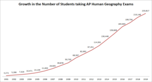
The number of students who took the AP Human Geography Exam from the year the exam started to 2019.
The exam is structured so that it contains a section of multiple choice questions scored with a scantron as well as a free-response section containing three essay style questions. AP Human Geography Readers score the free-response questions throughout the course of seven 8 AM to 5 PM days. The reading days are kept on a strict schedule to keep on pace to ensure that the scoring is complete by 5 PM on June 8. To score the exams, a rubric is developed by a group of question leaders made up of college professors who then train the readers on how to use the rubric to score the questions. This process ensures that readers are scoring as consistently as possible. The AP Human Geography exam is one of the fastest growing AP exams currently being offered. In 2001, the first year the exam was available, 3,272 students completed the test. In 2019, 233,817 students took the AP Human Geography exam. Because of the growth in the number of exams needing to be scored, the number of readers who attend the event has also grown. In 2019, approximately 950 readers were present to score the AP Human Geography exam, up from 794 in 2018.
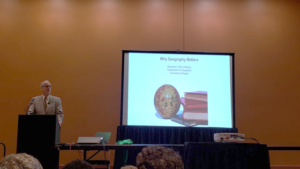
AAG Past President Alec Murphy gives his keynote address at the AP Human Geography ReadingAAG Past President Alec Murphy gives his keynote address at the AP Human Geography Reading
During the evenings at the AP Human Geography Reading, professional development activities ranging from academic speakers to networking to a Human Geography Bowl are organized. Past AAG President Alec Murphy was the 2019 featured keynote speaker with his presentation “Why Geography Matters” where he discussed his role in establishing the AP Human Geography course and the importance of the discipline to create contemporary global citizens. Another popular night is the Night of the Round Tables, an evening to share teaching resources with AP Human Geography high school teachers. During the 2019 Night of the Round Tables, Emily shared the AAG’s Profiles of Professional Geographers and the Guide to Geography Programs in a short presentation. By giving high school teachers these resources, students who have an interest in pursuing a career in geography will be more knowledgeable about which universities have geography programs when deciding where to attend college.
Share
New Books for Geographers
New Books: June 2019
Every month the AAG compiles a list of newly-published books in geography and related areas. Some are selected for review in the AAG Review of Books.
Publishers are welcome to send new volumes to the Editor-in-Chief (Kent Mathewson, Editor-in-Chief, AAG Review of Books, Department of Geography and Anthropology, Louisiana State University, Baton Rouge, LA 70803).
Anyone interested in reviewing these or other titles should also contact the Editor-in-Chief.
PLEASE NOTE: Due to current public health policies which have prompted the closing of most offices, we are unable to access incoming books at this time. We are working on a solution during this transition and will continue our new books processing as soon as we can. In the meantime, please feel free to peruse previous books from our archived lists.
“As Geography research begins in the field and ends in the field, so does my Presidential Column. I had the good fortune to be able to compose most of my first column (July 2018) during my fieldwork in Belize and Guatemala in Central America. Now I am filing my final column as your AAG President from field camp in northwestern Belize, working with an international team of colleagues, students, and volunteers to study the resilience of ancient Maya society… I thank you, my readers and fellow AAG members, for the Opportunity to freely explore challenging and timely issues and to share thoughts and opinions on current events and research over the last year.”
The 2020 AAG Annual Meeting will be headquartered in downtown Denver, Colorado at the Hyatt Regency – Convention Center. While many of the special events and sessions will be taking place at the Hyatt Regency – Convention Center, the neighboring Sheraton – Denver Downtown will also house some of the meeting. A block of rooms is now available for AAG Meeting attendees to reserve at a discounted rate.
Mark your calendar for the AAG Annual Meeting in the Mile High City April 6-10, 2020. Registration and the call for papers for #aagDENVER will be announced this summer. We look forward to seeing you in the Rocky Mountains!
AAG seeks two editors for the Annals of the American Association of Geographers
The flagship journal of the AAG, the Annals of the American Association of Geographers, has two upcoming editor vacancies to start January 2020. The open positions are in the subject areas of Human Geography and Nature & Society. Applications for the four year term will be accepted until September 6, 2019, with appointments being made in the fall of 2019.
Updated each academic year, the Guide lists undergraduate and graduate programs in all areas of geography and includes an interactive map that students can use to explore and discover geography programs, with easy-to-use search tools to find programs by degree type, region, and program specialization. It has long been an invaluable reference for faculty, prospective students, government agencies, and private firms in the United States, Canada, and throughout the world.
For more information and to list your program, please contact Mark Revell at guide [at] aag [dot] org.
Call for AAG Honors and Nominating Committees
The AAG Council seeks nominations for candidates to serve on the AAG Honors Committee and the AAG Nominating Committee. The Council will prepare the final slate of candidates for both committees from the nominations received, and committee members will be elected by a vote of the AAG membership. The Honors Committee submits nominations for awards and fellows to the Council every fall. The Nominating Committee recommends to the Council the slate of candidates for the AAG Vice President, President, and National Councilor elections.
If you wish to nominate yourself or other qualified individuals for service on these committees, please send your recommendations by email to AAG Secretary Cathleen McAnneny by June 30, 2019.
MEMBER NEWS
Profiles of Professional Geographers
You can make a difference with geography and GIS at any stage in your career. Just ask Carlos Saavedra who is spending his retirement doing volunteer work at Puerto Rico Rises, Dallas GiveCamp and the Boy Scouts of America. Carlos stresses the importance of GIS in today’s economy, saying that “the most fulfilling thing is that I can share how GIS works and educate non-profit organizations on how this tool can change the way they do business.”
A new research paper entitled “Extracting human emotions at different places based on facial expressions and spatial clustering analysis” was published in Transactions in GIS, led by the research team of Yuhao Kang with his advisor Dr. Song Gao at the Geospatial Data Science Lab at the University of Wisconsin-Madison along with their collaborators from Wuhan University, Peking University, and New Jersey Institute of Technology. Related to this work, graduate student Yuhao Kang won first place in the 2019 AAG Robert Raskin best student paper competition from the AAG Cyberinfrastructure Specialty Group. Learn more.
Thirty-three students and early career scholars will participate in the summer school on Reproducible Problem Solving with CyberGIS and Geospatial Data Science. The week long program will be co-led by the CyberGIS Center for Advanced Digital and Spatial Studies at the University of Illinois at Urbana-Champaign, the American Association of Geographers, and the University Consortium for Geographic Information Science. Learn more.
RESOURCES AND OPPORTUNITIES
New Geography & Indigenous Studies Programs Interactive Map
In consultation with the Indigenous Peoples Specialty Group, the AAG has developed a new resource to assist Indigenous students in finding safe places to pursue geography education. This interactive map highlights geography and Indigenous Studies programs throughout the US and Canada as well as those colleges and universities that offer support systems for Indigenous students. The resulting database of 185 schools is now available online and will be a part of the 2019-2020 Guide to Geography Programs in the Americas.
The Scientific Committee on Antarctic Research has fellowships to help early career researchers join a project team from another country that is working in the Antarctic. For 2019, 5 to 6 fellowships of up to $15,000 will be awarded for the purpose of creating lasting partnerships over the course of several research seasons in the Antarctic. The deadline for fellowship applications is July 17, 2019.
The International Geographical Union has announced its next Congress to be held August 17-21, 2020 in Istanbul, Turkey. The submission deadline for session proposals is July 31, 2019. Other key dates are: August 1, 2019 – Early registration starts; January 13, 2020 – Deadline for submitting abstracts for papers and posters; February 24, 2020 – Notification of results of abstract reviews; and March 9, 2020 – Deadline for early registration fee payment.
Taking Steps to Create a Welcoming Discipline for ALL Geographers: A New Resource for Indigenous Students
The AAG is pleased to announce the release of a new interactive web map of colleges and universities that offer both Geography Programs and Indigenous Studies Programs. Developed in consultation with members of the AAG’s Indigenous Peoples Specialty Group (IPSG), the map serves to help Indigenous students find safe places to pursue a Geography degree. In this case safe places refer to colleges and universities that have an active Indigenous Studies program, cultural center, or other active organization that can act as a support system for Indigenous students to keep them connected to their traditional communities and provide mentorship to help them achieve their academic goals. In many cases, this also includes colleges and universities that are geographically accessible to students, meaning the school is a commutable distance from their homes or within their home state for the purposes of in-state tuition.
There is a strong record of the application of geography, and specifically GIS, to address the needs of Tribal Governments and associated communities. Tracking land ownership records for resource management and land claims,[1],[2] assisting Tribal Governments with improving medical services, transportation, and economic development, and the preservation of cultural and natural resources[3],[4] represent a few of the ways spatial techniques and GIS have assisted indigenous communities. Coupled with the expectation that the GIS industry will grow by 10% each year through 2023[5], encouraging Indigenous students to pursue Geography could not only present opportunities in a growing field but provide tools and skills to better serve the needs of their own communities.
AAG Membership Data
Since 1981, the AAG has seen a gradual increase in the number of minorities within its membership. In the early 2000s there was a dramatic increase in the number of members who identify as Asian, African American, and Hispanic, however, the number of members who identify as Native Alaskan, Native American, or Pacific Islander has not followed that trend (Graph 1).[6] This suggests that Indigenous people have not been welcomed and included in Geography to the same extent as other underrepresented groups, a concern of the AAG as the Association is dedicated to “promoting inclusion, equity, and social justice across the entire discipline.”[7]
The Interactive WebMap
To address the need for greater Native American, Native Alaskan, and Pacific Islander representation in the AAG, the AAG has developed a database and interactive webmap to help students find schools suited to their needs. The database and interactive webmap was built by cross-referencing the American Indian Higher Education Consortium’s (AIHEC) list of Tribal Colleges,[8]the Guide to Native American Studies Programs in the U.S. and Canada,[9] and the AAG’s Guide to Geography Programs in the Americas[10] to identify schools in the US and Canada that qualify as a safe place. The academic catalog for each school was reviewed to determine if they offered both Geography Programs and Indigenous Studies Programs. Those that did were then added to the database along with information about the level of degrees offered in both fields as well as any cultural centers, administrative departments, or student organizations that would also be beneficial, as well as direct links to those websites.
Some of the identified colleges and universities do not offer degrees in both fields but were still included in the database because they have another structure in place that would also fulfill that need. For example few Tribal Colleges offer degrees in geography but do offer geography courses and, as institutions run by and for their communities, support structures for students are already available. Likewise, a couple of the schools included in this database do not offer an Indigenous Studies degree, but support research centers, cultural centers, or other partnerships with community organizations that would also fulfill that need. The result is a database of 185 colleges and universities across the United States and Canada.
Once the database was completed, a corresponding webmap was made as a method of searching the database spatially and includes filters to help students narrow down potential schools. The map includes two query tools that allow the user to select schools based on the degree they are interested in pursuing. One of these filters selects programs by the level of Geography degrees and the other sorts by the level of Indigenous Studies degrees. The application also includes a filter tool that allows the user to select schools by country (United States or Canada), State or Province, or highlight only Tribal Colleges.
For more information please contact:
Jolene Keen, Research Associate, American Association of Geographers
[1] Barcus, Holly R., and Laura J. Smith. “Facilitating Native Land Reacquisition in the Rural USA through Collaborative Research and Geographic Information Systems.” Geographical Research 54, no. 2 (12, 2015): 118-28. doi:10.1111/1745-5871.12167.
[2] Chapin, Mac, Zachary Lamb, and Bill Threlkeld. “Mapping Indigenous Lands.” Annual Review of Anthropology 34, no. 1 (10 2005): 619-38. doi:10.1146/annurev.anthro.34.081804.120429.
[3] Horn, Brady P., Gary N. Barragan, Chis Fore, and Caroline A. Bonham. “A Cost Comparison of Travel Models and Behavioural Telemedicine for Rural, Native American Populations in New Mexico.” Journal of Telemedicine and Telecare 22, no. 1 (05, 2015): 47-55. doi:10.1177/1357633×15587171.
[4] Deogawanka, Sangeeta. “How GIS Is Being Used to Help Native Americans ~ GIS Lounge.” GIS Lounge. November 10, 2014. https://www.gislounge.com/gis-used-help-native-americans/
[5] Dempsey, C. (2017, June 23). Global GIS Industry Continues to Grow ~ GIS Lounge. Retrieved from https://www.gislounge.com/global-gis-industry-continues-grow/
[6] Race and Ethnicity in Geography | AAG. (n.d.). Retrieved from https://www.aag.org/cs/disciplinarydata/raceandethnicity
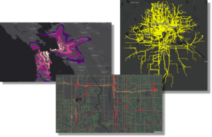
Beyond Compactness: A New Measure to Evaluate Congressional Districts
Redrawing congressional district boundaries, an activity that happens every ten years following the decennial census, may be the most consequential application of geography in the United States. As congressional elections have become less competitive, many are raising questions about the current boundaries of congressional districts, often citing lack of geographical compactness as their rationale. Geographical compactness generally ranges from 0 to 1, with 1 being a perfect circle. Wyoming’s only district is currently the most geographically compact district with a score of .77.
The U.S. Supreme Court has ruled multiple times that the assertion a district is oddly-shaped is insufficient to claim that the boundaries have been manipulated. In fact, some districts that score low in compactness can also be the most competitive. Odd shapes are sometimes needed to connect communities, to comply with the Voting Rights Act, or result from oddly-shaped states or coastal areas. Furthermore, communities rarely form in circles or squares naturally. Rather, communities rely more on existing administrative boundaries (counties, municipalities), infrastructure, and physical features to form.
A “Natural Communities” Score for District Boundaries
Esri’s Policy Maps team formed the research question: How much are current congressional boundaries defined by physical features (mountains and rivers), infrastructure (highways and railroads), or other existing administrative boundaries (county and place boundaries)? We calculated the percent of perimeter of each district that was a county boundary, a place (city, township, or other municipality) boundary, an interstate highway, a railroad track, a river, or within proximity to a mountain peak, as well as geographical compactness for comparison.
Using a statistical technique called factor analysis, we were able to create an index that incorporates all these measures and to determine the optimal weights for capturing as much information possible based on the correlations between variables. We call this the Natural Communities index. Not surprisingly, the results of the factor analysis suggested giving the most weight to sharing a boundary with an existing administrative boundary. The least weight was given to proximity to a mountain peak. Geographical compactness helps the score, but not by much since that measure was given such a low weight. The infrastructure measures both had sizeable negative weights, meaning that having infrastructure as a boundary is somehow negatively associated with our construct of natural communities and thus hurts a district’s score, perhaps because infrastructure is used to bring people together rather than separate them. Using these weights, we can come up with a “natural communities” score for each district. The scores were then standardized to have a mean of zero and a standard deviation of 1, for easy comparison. Districts that score high on our Natural Communities index are shown in green on the map below, whereas districts that score low are shown in brown.
States with only one district (Alaska, Delaware, Montana, North Dakota, South Dakota, Vermont, and Wyoming) generally scored highly, but these districts having different values does not make sense since there were no other options these districts could have used. We gave all these districts a “perfect” score of 2.0, shown in dark green in the map.
A Look at Specific Districts
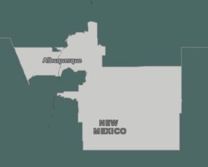
New Mexico’s 1st
New Mexico’s 1st District scored average (0). This district has 60.4 percent of its perimeter defined by administrative boundaries (national average was 65.4 percent), and 2.4 percent defined by a major highway (national average was 2.3 percent).
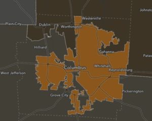
Ohio’s 3rd
Ohio’s 3rd District scored very low (-3.5). This district has only 16.3 percent of its perimeter defined by administrative boundaries (national average was 65.4 percent), and high percentages defined by the two infrastructure categories – railroad tracks and major highways – which has a negative impact on the score.
Arkansas’ 2nd
Arkansas’ 2nd District scored very high (+1.4). This district has 100 percent of its perimeter defined by administrative boundaries (national average was 65.4 percent), zero percent defined by infrastructure, and 37.5 percent defined by a river or stream (national average was 18.1%).
Our index adds information by accounting for the existing administrative boundaries as well as considering infrastructure and physical geographic features. This new score provides much more context when evaluating congressional district boundaries than simply geographical compactness. For example, Arkansas’ 2nd District is slightly less compact than New Mexico’s 1st District but scores much higher when taking into account the existing administrative boundaries (counties and places) and physical geographic boundaries (rivers and mountain peaks).
Join the Discussion
Our natural communities score can be used going into the upcoming redistricting exercises when evaluating multiple proposed districts. This score can add to the conversation when communicating proposed plans to the public during briefings and comment periods.
Diana C. Lavery is a product engineer on Esri’s Living Atlas and Policy Maps teams.
Share
Newsletters
Newsletter – April 2019
PRESIDENT’S COLUMN
Postcard from Mesoamerica
By Sheryl Luzzadder-Beach
“As Geography research begins in the field and ends in the field, so does my Presidential Column. I had the good fortune to be able to compose most of my first column (July 2018) during my fieldwork in Belize and Guatemala in Central America. Now I am filing my final column as your AAG President from field camp in northwestern Belize, working with an international team of colleagues, students, and volunteers to study the resilience of ancient Maya society… I thank you, my readers and fellow AAG members, for the Opportunity to freely explore challenging and timely issues and to share thoughts and opinions on current events and research over the last year.”
The 2020 AAG Annual Meeting will be headquartered in downtown Denver, Colorado at the Hyatt Regency – Convention Center. While many of the special events and sessions will be taking place at the Hyatt Regency – Convention Center, the neighboring Sheraton – Denver Downtown will also house some of the meeting. A block of rooms is now available for AAG Meeting attendees to reserve at a discounted rate.
Mark your calendar for the AAG Annual Meeting in the Mile High City April 6-10, 2020. Registration and the call for papers for #aagDENVER will be announced this summer. We look forward to seeing you in the Rocky Mountains!
AAG seeks two editors for the Annals of the American Association of Geographers
The flagship journal of the AAG, the Annals of the American Association of Geographers, has two upcoming editor vacancies to start January 2020. The open positions are in the subject areas of Human Geography and Nature & Society. Applications for the four year term will be accepted until September 6, 2019, with appointments being made in the fall of 2019.
Updated each academic year, the Guide lists undergraduate and graduate programs in all areas of geography and includes an interactive map that students can use to explore and discover geography programs, with easy-to-use search tools to find programs by degree type, region, and program specialization. It has long been an invaluable reference for faculty, prospective students, government agencies, and private firms in the United States, Canada, and throughout the world.
For more information and to list your program, please contact Mark Revell at guide [at] aag [dot] org.
Call for AAG Honors and Nominating Committees
The AAG Council seeks nominations for candidates to serve on the AAG Honors Committee and the AAG Nominating Committee. The Council will prepare the final slate of candidates for both committees from the nominations received, and committee members will be elected by a vote of the AAG membership. The Honors Committee submits nominations for awards and fellows to the Council every fall. The Nominating Committee recommends to the Council the slate of candidates for the AAG Vice President, President, and National Councilor elections.
If you wish to nominate yourself or other qualified individuals for service on these committees, please send your recommendations by email to AAG Secretary Cathleen McAnneny by June 30, 2019.
MEMBER NEWS
Profiles of Professional Geographers
You can make a difference with geography and GIS at any stage in your career. Just ask Carlos Saavedra who is spending his retirement doing volunteer work at Puerto Rico Rises, Dallas GiveCamp and the Boy Scouts of America. Carlos stresses the importance of GIS in today’s economy, saying that “the most fulfilling thing is that I can share how GIS works and educate non-profit organizations on how this tool can change the way they do business.”
A new research paper entitled “Extracting human emotions at different places based on facial expressions and spatial clustering analysis” was published in Transactions in GIS, led by the research team of Yuhao Kang with his advisor Dr. Song Gao at the Geospatial Data Science Lab at the University of Wisconsin-Madison along with their collaborators from Wuhan University, Peking University, and New Jersey Institute of Technology. Related to this work, graduate student Yuhao Kang won first place in the 2019 AAG Robert Raskin best student paper competition from the AAG Cyberinfrastructure Specialty Group. Learn more.
Thirty-three students and early career scholars will participate in the summer school on Reproducible Problem Solving with CyberGIS and Geospatial Data Science. The week long program will be co-led by the CyberGIS Center for Advanced Digital and Spatial Studies at the University of Illinois at Urbana-Champaign, the American Association of Geographers, and the University Consortium for Geographic Information Science. Learn more.
RESOURCES AND OPPORTUNITIES
New Geography & Indigenous Studies Programs Interactive Map
In consultation with the Indigenous Peoples Specialty Group, the AAG has developed a new resource to assist Indigenous students in finding safe places to pursue geography education. This interactive map highlights geography and Indigenous Studies programs throughout the US and Canada as well as those colleges and universities that offer support systems for Indigenous students. The resulting database of 185 schools is now available online and will be a part of the 2019-2020 Guide to Geography Programs in the Americas.
The Scientific Committee on Antarctic Research has fellowships to help early career researchers join a project team from another country that is working in the Antarctic. For 2019, 5 to 6 fellowships of up to $15,000 will be awarded for the purpose of creating lasting partnerships over the course of several research seasons in the Antarctic. The deadline for fellowship applications is July 17, 2019.
The International Geographical Union has announced its next Congress to be held August 17-21, 2020 in Istanbul, Turkey. The submission deadline for session proposals is July 31, 2019. Other key dates are: August 1, 2019 – Early registration starts; January 13, 2020 – Deadline for submitting abstracts for papers and posters; February 24, 2020 – Notification of results of abstract reviews; and March 9, 2020 – Deadline for early registration fee payment.
The field of artificial intelligence (AI) isn’t new, and neither are its grand promises. AI as an academic pursuit has its roots in the 1950s. Early AI researchers were filled with optimism, but—despite some initial work that appeared groundbreaking, such as the first artificial neural networks—the field saw slow progress over the next several decades. By the mid-1970s, the field had hit a bit of a roadblock—there was a loss in interest largely due to inflated expectations as well as the failure to deliver on the promise of AI. This period is known as the first AI winter.
Following the first AI winter, advances in the field saw AI once again, albeit slowly, gaining momentum and funding, but only for a brief time. By the early-1990s, AI had again failed to live up to expectations. While AI had been tightly integrated into people’s everyday lives, it still largely failed on problems that most humans deem simple, such as recognizing features in images or understanding speech. With a 40-year history and a failure to live up to the hype, things appeared bleak for AI.
Then something happened. In the last decade, due to the advent of massive volumes of data gathered from the Internet and powerful graphics processing units (GPUs) capable of supercomputer-like performance on certain tasks, a particular type of AI algorithm has seen massive resurgence. These algorithms are known as artificial neural networks because they loosely resemble biological neural networks such as those in the human brain. Since 2010, these algorithms have experienced exponential increases in performance on numerous benchmarks, including some that were thought to be out of reach by many. Neural networks have even achieved superhuman performance in a few domains. Though still not quite reaching the level of promise visualized during the 1950s, AI is at the point where it is already making a massive impact everywhere. This includes in geographic information system (GIS) technology.
The types of data that we look at in the geospatial realm can be broadly categorized into two types: structured and unstructured. Structured data includes vector data—parcel boundaries, roads, GPS bread crumbs, and so on. Unstructured data refers to raster data, voice, and text, which—while typically very usable by humans—is difficult for machines to extract actionable information from.
This is changing rapidly; major advances in AI have made it possible to unlock the potential of unstructured data, and to do so at scale. Deep learning—so called because it applies “deep” artificial neural networks that often are composed of hundreds of connected layers of calculation—has enabled a new revolution in the processing of unstructured data. For those of us working in GIS, this means massive increases in productivity.
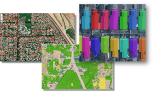
Deep learning has created the ability to very accurately detect objects and classify pixels at scale. Exploitation of aerial, satellite, and street-view images and videos are some of the common uses that we see at Esri. Deep learning enables endeavors such as large-scale high-resolution land cover mapping, the detection and digitization of buildings and roads, and rapid exploitation of drone imagery to detect asset damage, to name a few. Recent advances in processing voice and text by using deep learning allow geospatial analysis without manual extraction of geospatial entities. A fascinating new class of algorithms, called Generative Adversarial Networks (GAN), can generate realistic—but fake—data, including photographs! At Esri, we’ve been investigating numerous applications of GAN, ranging from generating 3D models to simulating spatiotemporal data and even performing automatic cartographic map styling, as shown at right.
AI can also add value to structured data for tasks, including predicting geospatial events such as car crashes or crime, estimating drive times, or helping businesses determine where to construct the next new store. The list goes on—we are nowhere close to tapping all the potential of machine learning.
The thing is, the GIS community has been using AI for a very long time. Performing regression, kriging, clustering, hot-spot analysis—these capabilities have been adopted into a subfield of AI called machine learning. Machine learning, at its core, is composed of approaches that learn from data rather than being explicitly programmed. Machine learning has been changing the world for decades, though it’s only recently that the public has started to become aware. This is mostly due to the emergence of deep learning.
Adoption of newer machine learning approaches into geospatial workflows has been slow. But why? As GIS practitioners know very well, GIS is hard—often, subtly so. While massive advances have been made in machine learning, very little thought has gone into making these approaches spatial. This leaves geographers shaking their heads in disapproval when geospatial processing is not only excluded from machine learning algorithms but may be flat-out ignored! Machine learning researchers and data scientists typically don’t understand the significant challenges that something as ubiquitous as terrain brings to the table when estimating the travel time between two locations. Furthermore, the appropriate distance between objects is often ignored or handled poorly. If close things are more related than distant things, machine learning often doesn’t treat this with any rigor.
To overcome these challenges, GeoAI—the combination of AI and GIS—is beginning to take off. Applying AI within a spatial context requires a new approach, but organizations are beginning to recognize the power that geography brings to the table. Sometimes this may mean preparing data differently to account for spatial challenges, and other times this may require a whole new approach. The AI team at Esri has been actively bringing these two fascinating fields together, but it’s in global action that there will be change.
AI hasn’t yet lived up to the original mission—to produce human-level intelligent machines—but it doesn’t have to! We don’t need human-level intelligence to make a human-level impact. AI is here, and it’s not going away this time.
We’re getting closer to the 2019 AAG Annual Meeting! Whether you will be attending the meeting all week, for a few days, or looking to follow the action from afar, there are plenty of ways to get involved using social media. Social media is a great way for seasoned conference goers and newcomers alike to network, report on new research, engage in lively debate with those inside and outside of the discipline, and find out what’s going on during the largest geography conference in the world! Start planning your #aagDC social media strategy today with these helpful guidelines!
Twitter
One of the most frequently used social media sites for live events, Twitter is a great place to start scoping out the annual meeting. Twitter is used by geographers to discuss and share research ideas or connect with others, often leading to face to face meet-ups at the annual meeting. As the main social media channel, the AAG annual meeting has had active Twitter users since at least 2011 in Seattle. The hashtag #AAG followed by the year of the event used to be the standard AAG Annual Meeting tag. However, this year we decided to switch it up! Due to increased traffic from other events who are already using #AAG2019 (hat tip to the ASEAN Autism Games) and the fact that as geographers we are always thinking about place and space, we will now use the hashtag #aag followed by the location of the conference. This year the official conference hashtag will be #aagDC! Start using and following #aagDC; posts are already being compiled in anticipation of the meeting! If you are new to Twitter, try these tips to benefit most from the network:
Follow @theAAG on Twitter! The official AAG Twitter account will be active throughout the meeting with important announcements, live tweets of events, and fun photos throughout the conference hotels. Due to popularity, the AAG will continue to conduct a Twitter poll once a day for members to choose a session they would like to see live-Tweeted!
Use #aagDC on all your meeting related communications. Sometimes it is difficult to fit your thoughts into the (now expanded!) 280 character count, but try to include the hashtag #aagDC in each of your tweets. This will ensure that your tweets are being seen by others both at the conference and following along offsite. If you are new to hashtags, a hashtag is a way to organize a specific topic into one feed. Click on the hashtag to see the conversations happening related to that topic.
Whenever possible, try to include Twitter handles. If you are tweeting about a paper, panel, or poster, be sure to attribute the research to the right person by using their Twitter handle. Presenters and panelists should consider including their handles on an opening slide or in a poster corner. Conversely, if you do not want your research to be tweeted, please state that information upfront so the audience is aware of your desires.
Unable to attend the meeting this year? Follow the hashtag and join the conversation!
Facebook
Do you prefer Facebook over Twitter as your social media site of choice? While there will be less live coverage of specific sessions, Facebook is a great way to share photos, videos, and news about the annual meeting with your friends, family, and colleagues.
Make sure you like the AAG Facebook page (www.facebook.com/geographers) and set the page so that you see it first in your News Feed by clicking on the “Following” dropdown menu on the AAG Facebook page itself. This will ensure that you receive the latest meeting related announcements as soon as you open the Facebook app or website.
Be on the lookout for Facebook Live videos from some of the major events like the Exhibition Hall opening and the World Geography Bowl finals!
Check on the page each morning for reminders of the day’s schedule of events.
Instagram
The AAG’s newest social media channel, Instagram is a fun place to share your photos of activities at the annual meeting and your daily life as a geographer!
Follow @theAAG on Instagram for photos of the annual meeting as well as behind the scenes looks at the work that goes into planning the conference on a yearly basis!
Share your photos of the meeting with other attendees using the conference hashtag #aagDC and look for an Instagram collage of #aagDC photos after the meeting ends.
Want to be featured in our new Instagram Campaign to meet members of the AAG, #MeettheAAG? Look for AAG Staff throughout the meeting who will be taking photos and collecting information about AAG members that will be showcased during the summer.
General Communications
Because the AAG social media channels will be busy during the annual meeting, AAG staff may not be able to provide a timely reply through these mediums. The AAG Annual Meeting App is a good place to start for conference information with regards to floor plans, session times and locations, and abstracts. If you have questions or concerns and need to contact a staff member, the best option is to find a conference volunteer (wearing a neon yellow t-shirt) or to stop by the AAG Meridian or Registration area in the Atrium of the Marriott Hotel.
Share
Post
Rights of Nature: The New Paradigm
Rights of Nature is a short-hand term for a form of ecological governance that both provides for and prioritizes Nature’s right to flourish. It also provides for various subsidiary rights, such as the right to restoration, the right to its natural processes, and the right to ecosystem functioning without interference. The term “Rights of Nature” gives the impression that the primary focus is defending Nature’s rights in courts of law. However, the Rights of Nature paradigm aims for a more fundamental shift in governance than only defending rights: placing Nature and its needs before human needs, so that human needs are reconfigured within Nature’s limits. Providing Nature with legal personhood and the guardians to defend its rights in court helps change the framework to a form of ecological governance, rather than laws that provide only for human needs. Currently, American law merely regulates human uses of the natural environment and provides for minimal curbs on overuse by such means as fines for pollution or, more rarely, refusal to grant permits for projects deemed too ecologically damaging.
What is Rights of Nature Governance?
The upsurge in interest in ecological governance is driven by the clear signals worldwide of increasing ecological degradation at systemic levels, ranging from climate change to greatly accelerated species loss across ecosystems. It is clear to many thinkers and advocates that the current industrial paradigm is now threatening ecological integrity worldwide and with it the ability of human communities to live sustainably and support critical needs for food, fresh water, decent shelter and ways of making a living.
Rights of Nature is less a specific template than an overarching ideal of ecological governance, the details of which are fashioned in unique ways in each culture that is seeking to enhance or restore sustainable living within Nature’s limits. This requires that Nature be granted the same rights to flourish and maintain itself as humans grant themselves in their legal structures. But underlying the need for legal protections is the concept that humans and Nature are in a relationship, rather than Nature merely providing a hoard of natural resources for indiscriminate human use. The legal structures discussed in Rights of Nature literature codifies the details of this restored relationship, rather than actually creating it.
Fully implementing a Rights of Nature or similar form of ecological governance, is the only way to reach true sustainability, because it places human activities within the framework of Nature’s laws and limitations, as other forms of governance do not. The problem, however, is how to define “sustainability,” as this overused term has lost both its mooring and meaning. Four criteria need to guide an understanding of the sustainability that a Rights of Nature paradigm aims for: (a) true sustainability prohibits mitigation or substitution for monetary or political gain; (b) sustainable projects create sustainable levels of human use, rather than encouraging continued over-consumption; (c) sustainable use shrinks the human footprint on the earth, not expands it; (d) true sustainability is a flexible and continuous process, as populations, technologies, and needs change, but it always maintains Nature’s biophysical integrity throughout, despite the dynamic changes inherent in ecological processes.
The History of the Rights of Nature Paradigm
The idea of granting Nature legal rights originated in a court case decided in 1972 by the United States Supreme Court, Sierra Club versus Morton. The Forest Service had issued permits for Disney Enterprises to build a complex of recreation and lodging facilities in Mineral King Valley in the Sierra Nevada of California. The Sierra Club Legal Defense Fund sued to stop the project, but the lower court held that the Fund would not be adversely affected by the project and thus had no legal standing to sue. The United States Supreme Court decided to hear the case. As the case was pending, Christopher Stone, a professor at the University of California School of Law, authored a law review article arguing that natural areas and objects should have legal rights to defend their ecological integrity from harms that would damage them.
Mineral King Valley, now part of Sequoia National Park, California. Photo courtesy of National Park Service.
The country of Ecuador was the first to place Rights of Nature in its governing laws. Section 7 of the new Constitution of Ecuador adopted in 2008 says, “Nature, or Pacha Mama, where life is reproduced and occurs, has the right to integral respect for its existence and for the maintenance and regeneration of its life cycles, structure, functions and evolutionary processes.” The Constitution also grants Nature the right to be restored and requires the government to prevent or restrict activities leading to species extinction, ecosystem destruction, and permanent alteration of natural cycles. Significantly, the Ecuadoran Constitution also protects its people’s rights to food sovereignty, and the right, especially of indigenous peoples, to remain on their ancestral lands, protecting their rights to develop ancestral traditions and societies and retain ownership of their community lands.This article, entitled “Should Trees Have Standing?” caught the attention of Supreme Court Justice William O. Douglas. The Court ruled against the Sierra Club, but Justice Douglas wrote a now-famous dissent in which he said, “Contemporary public concern for protecting nature’s ecological equilibrium should lead to the conferral of standing upon environmental objects to sue for their own preservation.” Ultimately, the Sierra Club was able to prevent the destruction of Mineral King Valley, which is now part of Sequoia National Park. Professor Stone’s provocative article, suggesting that Nature be granted legal personhood to protect its own integrity, slowly began to attract more attention.
This new Constitutional provision on Nature’s Rights is slowly changing the face of Ecuadoran law. The very first lawsuit using the Rights of Nature provision was decided in Ecuador in 2011. It concerned a new road built along the Vilcabamba River in Loja Province and the dumping of construction rubble into the river. The Provincial Justice Court of Loja ruled in favor of the river, noting that damage to nature is generational in extent and that therefore the “precautionary principle” should guide development projects. The court required the government to take immediate corrective actions and appointed a delegation to oversee the cleanup.
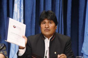
Evo Morales Ayma, President of Bolivia and Rights of Nature advocate, holding up a manual of the World People’s Conference on Climate Change and the Rights of Mother Earth during a press conference at UN Headquarters on May 7, 2010. United Nations photograph by Eskinder Debebe.
Other recent efforts include a state court in India granting legal personhood to the heavily polluted Ganges and Yamuna Rivers, and local Rights of Nature legislation in various regions of the United States. Most recently (in February 2019), the people of Toledo, Ohio passed a Bill of Community Rights and Nature’s Rights to protect Lake Erie, subject to nearly annual toxic algal blooms, mainly as a result of industrial agricultural practices in the lake’s watershed. The legislation passed with 61% of the vote, but is already subject to a lawsuit, as nearly all other such local attempts in the United States have been.Bolivia subsequently, in 2010, enacted a comprehensive Rights of Nature statute, and also hosted an international gathering of concerned organizations from around the world, which led to the founding of the Global Alliance for the Rights of Nature. Advocates and governments worldwide are also experimenting with innovative ways to approach ecosystem protection that reach past the current human-centered legal paradigm. One of the most successful is in New Zealand, where a fusion of Western legal concepts and Maori traditions of the Whanganui River’s importance as an ancestor, and Maori responsibilities to protect and conserve it, led to a formal agreement, finalized in 2012, to grant the river a legal identity. The implementing legislation passed in 2017. The definition of the river is adopted from the Whanganui iwi, the Maori group whose entire history is tied to the river. The river is defined as a living and integral whole, whose life is inseparable from the Whanganui iwi. Appointed guardians from the Whanganui iwi and the New Zealand government now protect the river. This successful project is considered a model for other efforts to blend indigenous law and tradition with Western legal structures for the protection of Nature.
The reason is not hard to seek: a Rights of Nature legal structure, if implemented nationwide, would constitute a monumental shift in the way Americans approach Nature, with relationship to Nature as the foremost goal, and the protection and flourishing of Nature given primacy over natural resources extraction and use. It would change the basis and thrust of the economy. Thus far, all attempts at Rights of Nature legislation in the United States have been local. These locally-approved laws clash with the hierarchical structure of American governance, which pre-empts most natural resources regulation to state or federal levels.
Questions and Challenges for a Rights of Nature Paradigm
Clearly, major changes in human use of the environment must take place; the ecological signals are unmistakable that current levels are unsustainable. The question is how best to move forward. There are many unanswered questions about ecological governance. How would Rights of Nature laws be implemented? What level of Nature would be granted the right to flourish: a watershed, an entire ecosystem, a single river, a valley, the climate of the world? Who would determine whether a given use interferes with Nature’s well-being and how would it be measured? If there are damages, how would they be measured, what would the remedy be, and how would it be implemented? How would human communities reconfigure themselves to live sustainably and stably, without instability, poverty and excessive resource use? How would human needs and Nature’s need to flourish without interference be balanced to create wholeness for both parties?
These questions and many more are being explored in a growing trickle of papers, articles, and books. CRC Press published the first book surveying Rights of Nature activity worldwide since an environmental philosophy work by Roderick Nash in 1989. The new book, released in 2017, begins the conversation on changes needed in human land use patterns (in the United States). It is titled Sustainability and the Rights of Nature: An Introduction, by Cameron La Follette and Chris Maser. The authors recognize that implementing ecological governance and deep sustainability models is something that must be done locally, place by place, region by region. Therefore, they are working on a second book, Sustainability and the Rights of Nature in Practice, in which advocates, scholars, and government officials from around the world discuss the path ahead, and the challenges and opportunities they face, from places as diverse as Germany and Kiribati, Bhutan and Scotland, Nigeria and Venezuela.
The problems humans now face around the world, ranging from marine plastics to climate change to severe soil erosion and ecosystem depletion, require communities and nations to apply every creative means to restore the human relationship with Nature. This requires the best scientific information on ecosystems, geography, hydrology and many other fields. But it also requires collaboration between people of differing traditions who share a landscape and region, to forge new partnerships and models that can govern humans’ return to a relationship with Nature, which sustains all.
Some cultures have retained much of their traditional relationship with Nature, and the customs and laws governing it, especially indigenous peoples in many regions. But the industrial paradigm of extraction and use without limits – or very minimal limits – is commonplace worldwide, and wreaking havoc on ecosystems, income inequality, and environmental health and resilience. It is clear that the existing legal framework, which favors human use and restricts use only to maintain, at best, minimal levels of ecosystem function, must change. Rights of Nature, and other potential forms of ecological governance now being explored, provide the path to a new and vital relationship between humans and Nature.
Cameron La Follette has a Masters in Psychology from New York University, and a Law degree from Columbia University. She is the lead author on Sustainability and the Rights of Nature: An Introduction, and lead editor on the forthcoming book Sustainability and the Rights of Nature in Practice.
Share
Awardees
AAG Announces 2018 Book Awards
The AAG is pleased to announce the recipients of the three 2018 AAG Book Awards: the John Brinckerhoff Jackson Prize, the AAG Globe Book Award for Public Understanding of Geography, and the AAG Meridian Book Award for Outstanding Scholarly Work in Geography. The AAG Book Awards mark distinguished and outstanding works published by geography authors during the previous year, 2018. The awardees will be formally recognized at the Awards Luncheon during the 2019 AAG Annual Meeting in Washington, D.C.
The John Brinckerhoff Jackson Prize
This award encourages and rewards American geographers who write books about the United States which convey the insights of professional geography in language that is both interesting and attractive to lay readers.
David G. Havlick,Bombs Away: Militarization, Conservation, and Ecological Restoration (University of Chicago Press, 2018)
David Havlick’s Bombs Away takes us on a rich journey to some of the world’s best examples of former military lands undergoing ecological restoration. He probes the cultural and environmental consequences of this process and explores what happens to localities that were once bombed, fortified, and militarized spaces. The result is a beautifully-written and theoretically-informed narrative that exemplifies a new area of nature-society research, asks relevant questions about ecological restoration on former military lands, and illuminates an important, previously underappreciated type of cultural landscape, both in the United States and beyond.
The AAG Globe Book Award for Public Understanding of Geography
This award is given for a book written or co-authored by a geographer that conveys most powerfully the nature and importance of geography to the non-academic world.
Tara Patricia Cookson, Unjust Conditions: Women’s Work and the Hidden Cost of Cash Transfer Programs (University of California Press, 2018)
Tara Patricia Cookson’s outstanding book Unjust Conditions: Women’s Work and the Hidden Cost of Cash Transfer Programs is an elegantly written and accessible portrait of how rural women in Peru experience and cope with the often hidden and detrimental socioeconomic demands of a much-heralded development program. Through careful, self-aware ethnographic methods, Cookson (currently a Postdoctoral Research Scholar in the Department of Geography at the University of British Columbia) presents a powerful counter-argument to the fashionable yet problematic practice of “data-driven development”. Unjust Conditions should be required reading for students, scholars, the general public, and—most importantly—practitioners of development searching for innovative and socially just alternatives to conventional development thinking.
The 2018 AAG Meridian Book Award for Outstanding Scholarly Work in Geography
This award is given for a book written by a geographer that makes an unusually important contribution to advancing the science and art of geography.
Martin Doyle, Duke University, The Source: How Rivers Made America and America Remade its Rivers (W.W. Norton, 2018)
Martin Doyle’sThe Source is one of those rare books that advances both the science and art of geography. The Source is at once an environmental and political history of the United States. Doyle simultaneously provides an invaluable story of how rivers are intimately entangled with both the construction of the physical landscape, and an empirical study of how power has been etched onto that same landscape. Doyle adeptly picks apart some of the most intriguing connections among the various levels of governing bodies that are charged with dealing with water in the United States. The analysis shows how rivers not only contribute to the organization of a household via running water and indoor plumbing but also link to shaping cities beyond mere settlement, into the building of the nation itself. Well-researched and accessibly written, Doyle’s The Source embodies the spirit of the AAG Meridian Award.
Share
Register for Free
Create an account to get free access to exclusive AAG content.
AAG Members get exclusive access to publications, prominent journals, unique advocacy, grant, scholarship and professional opportunities with access to industry focus communities, and event discounts, including our annual meeting.
Some content may only be accessible if you belong to specific Specialty or Affinity Groups. You can still update your membership below. You will need to go through the Join flow, but you do not need to repurchase your membership unless it is expired or about to expire.
To provide the best experiences, we use technologies like cookies to store and/or access device information. Consenting to these technologies will allow us to process data such as browsing behavior or unique IDs on this site. Not consenting or withdrawing consent, may adversely affect certain features and functions.
Functional
Always active
The technical storage or access is strictly necessary for the legitimate purpose of enabling the use of a specific service explicitly requested by the subscriber or user, or for the sole purpose of carrying out the transmission of a communication over an electronic communications network.
Preferences
The technical storage or access is necessary for the legitimate purpose of storing preferences that are not requested by the subscriber or user.
Statistics
The technical storage or access that is used exclusively for statistical purposes.The technical storage or access that is used exclusively for anonymous statistical purposes. Without a subpoena, voluntary compliance on the part of your Internet Service Provider, or additional records from a third party, information stored or retrieved for this purpose alone cannot usually be used to identify you.
Marketing
The technical storage or access is required to create user profiles to send advertising, or to track the user on a website or across several websites for similar marketing purposes.
 “As Geography research begins in the field and ends in the field, so does my Presidential Column. I had the good fortune to be able to compose most of my first column (July 2018) during my fieldwork in Belize and Guatemala in Central America. Now I am filing my final column as your AAG President from field camp in northwestern Belize, working with an international team of colleagues, students, and volunteers to study the resilience of ancient Maya society… I thank you, my readers and fellow AAG members, for the Opportunity to freely explore challenging and timely issues and to share thoughts and opinions on current events and research over the last year.”
 The 2020 AAG Annual Meeting will be headquartered in downtown Denver, Colorado at the Hyatt Regency – Convention Center. While many of the special events and sessions will be taking place at the Hyatt Regency – Convention Center, the neighboring Sheraton – Denver Downtown will also house some of the meeting. A block of rooms is now available for AAG Meeting attendees to reserve at a discounted rate.
 The most recent issue of GeoHumanities has been published online (
 In addition to the most recently published journal, read the latest issue of the other AAG journals online:
 The flagship journal of the AAG, the Annals of the American Association of Geographers, has two upcoming editor vacancies to start January 2020. The open positions are in the subject areas of Human Geography and Nature & Society. Applications for the four year term will be accepted until September 6, 2019, with appointments being made in the fall of 2019.
 You can make a difference with geography and GIS at any stage in your career. Just ask Carlos Saavedra who is spending his retirement doing volunteer work at Puerto Rico Rises, Dallas GiveCamp and the Boy Scouts of America. Carlos stresses the importance of GIS in today’s economy, saying that “the most fulfilling thing is that I can share how GIS works and educate non-profit organizations on how this tool can change the way they do business.”
 In consultation with the Indigenous Peoples Specialty Group, the AAG has developed a new resource to assist Indigenous students in finding safe places to pursue geography education. This interactive map highlights geography and Indigenous Studies programs throughout the US and Canada as well as those colleges and universities that offer support systems for Indigenous students. The resulting database of 185 schools is now available online and will be a part of the 2019-2020 Guide to Geography Programs in the Americas.
 The International Geographical Union has announced its next Congress to be held August 17-21, 2020 in Istanbul, Turkey. The submission deadline for session proposals is July 31, 2019. Other key dates are: August 1, 2019 – Early registration starts; January 13, 2020 – Deadline for submitting abstracts for papers and posters; February 24, 2020 – Notification of results of abstract reviews; and March 9, 2020 – Deadline for early registration fee payment.
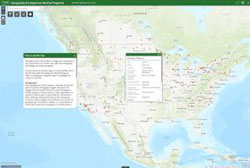 The AAG is pleased to announce the release of a
 ![Graph 1: AAG Minority Membership since 1981.[6]](https://www.aag.org/wp-content/uploads/2021/11/AAG-minority-membership-640x332-1-300x156.png)

 The thing is, the GIS community has been using AI for a very long time. Performing regression, kriging, clustering, hot-spot analysis—these capabilities have been adopted into a subfield of AI called machine learning. Machine learning, at its core, is composed of approaches that learn from data rather than being explicitly programmed. Machine learning has been changing the world for decades, though it’s only recently that the public has started to become aware. This is mostly due to the emergence of deep learning.
 We’re getting closer to the 2019 AAG Annual Meeting! Whether you will be attending the meeting all week, for a few days, or looking to follow the action from afar, there are plenty of ways to get involved using social media. Social media is a great way for seasoned conference goers and newcomers alike to network, report on new research, engage in lively debate with those inside and outside of the discipline, and find out what’s going on during the largest geography conference in the world! Start planning your #aagDC social media strategy today with these helpful guidelines!


 David G. Havlick, Bombs Away: Militarization, Conservation, and Ecological Restoration (University of Chicago Press, 2018)
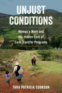 Tara Patricia Cookson, Unjust Conditions: Women’s Work and the Hidden Cost of Cash Transfer Programs (University of California Press, 2018)
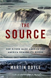 Martin Doyle, Duke University, The Source: How Rivers Made America and America Remade its Rivers (W.W. Norton, 2018)