Each year, the AAG invites nominations for AAG Honors to be conferred in recognition of outstanding contributions to the advancement or welfare of the profession. The AAG Honors Committee is charged with making award recommendations for each category, with no more than two awards given in any one category. This year, the AAG Honors Committee and the AAG Council are pleased to announce the following AAG Honorees to be recognized during the 2020 AAG Annual Meeting Awards Luncheon.
2020 AAG Lifetime Achievement Honors
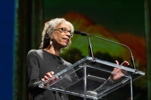 Ruth Wilson Gilmore, Graduate Center, CUNY
Ruth Wilson Gilmore, the recipient of this year’s AAG Lifettime Achievement Award, is a public intellectual who integrates geographic scholarship with advocacy and activism. This award recognizes Dr. Gilmore’s transformational contributions to the discipline of Geography. Her scholarship has pushed the boundaries of geographic thought and influenced the trajectories of multiple areas of our field, including critical human geography, black geographies, and political economic geography. Dr. Gilmore is also an advocate for geographic thinking and the importance of space and place within interdisciplinary fields including American studies, carceral studies, and ethnic studies.
Dr. Gilmore is particularly known for her work in carceral studies, including her award-winning book, Golden Gulag: Prisons, Surplus, Crisis and Opportunities (soon to be re-issued by University of California Press). Golden Gulag brought the theoretical and methodological tools of economic geography to bear on the interconnections of race, space and inequity, reshaping the national conversation on prisons. In this book and in related articles, chapters, and lectures, she pushed scholars, politicians and citizens to confront society’s highly inequitable valuation of different lives. In addition to her contributions on prison abolition, Dr. Gilmore’s research addresses racial capitalism, organized violence, and labor and social movements. She is known for her depth of knowledge, meticulous analysis and theoretical agility.
Dr. Gilmore’s powerful scholarship has been paired with deep engagement in public-facing scholarship. She is the quintessential intellectual-activist, engaging a wide range of audiences in the U.S. and internationally on the role of the state in taking and preserving life. Dr. Gilmore is also an extraordinary mentor of undergraduate and graduate students and of junior and mid-career scholars. She is described by her mentees as a “formidable, uncompromising, generous and greatly beloved scholar”. Through her mentorship, Dr. Gilmore has shaped a new generation of public scholars within Geography.
The discipline of Geography has benefited enormously from Dr. Gilmore’s scholarship, activism, and mentorship. She is a role model for all of us. (Photo credit ©DonUsner)
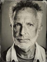 Michael Watts, University of California – Berkeley
Michael Watts, recipient of the 2020 AAG Lifetime Achievement Award, is one of the most influential nature/society scholars of the last fifty years. His foundational research on political ecology, vulnerability and resilience, agrarian political economy, the social production of famine, oil
and development, and environmental justice – all conducted through a fine-grained ethnographic, political, and deeply historical engagement with Nigeria and West Africa – continues to shape scholarly debates and research programs across the environmental social sciences, area studies, and humanities.
Watts’ work is widely cited and taught. He has written two powerful monographs – Silent Violence: Food, Famine, and Peasantry in Northern Nigeria (1983/2013 2nd ed.) and Curse of the Black Gold: 50 Years of Oil in the Niger Delta (2014) – and more than 300 articles and essays. He is perhaps best known for his edited volumes, which have been no less than field-defining. He has set and then reset the intellectual trajectory of political ecology and critical nature/society research three times in twenty years with the various editions of Liberation Ecologies, initially published in 1996 and then entirely overhauled twice: first for a 2nd edition in 2004, and then again for a 3rd edition retitled Global Political Ecology, which was published in 2011. His 2001 collection Violent Environments (with Nancy Peluso), catalyzed a body of research focused on the role of armed conflict in environmental conservation world-wide which continues today in work on the role of armed drones in wildlife protection. His recent co-edited volume Subterraenean Estates: Life Worlds of Oil and Gas (2015) promises to play a similarly defining role in research on the environmental and political impacts of fossil fuel extraction. He has received numerous awards including the Victoria Medal of the Royal Geographical Society and AAG Distinguished Scholarship Honors. In addition to funding from NSF and the National Geographic Society, his research has been funded by major foundations including Ford and Rockefeller. He has also received a Guggenheim.
As the Class of 1963 Professor of Geography and Development Studies at Berkeley, he supervised 90 Ph.D. students and served on the committees of 75 others. His service to Geography and academia more broadly includes co-founding and directing the storied Environmental Politics Workshop at UC Berkeley, and serving as Chair of the Board of Trustees of the Social Science Research Council for more than a decade and on the advisory board for the Stanford Center for Advanced Studies in the Behavioral Sciences. Beyond academia, Watts has worked at the highest levels of international development (serving as Chief of Party for the United National Development Program and working with the World Bank), corporate governance (arranging workshops on corporate social responsibility for companies such as Statoil and Genentech), statecraft (working with the U.S. Congress and State Department on oil issues), and community activism (collaborating with photojournalists and the environmental justice collective RETORT). These multi-faceted engagements with diverse stakeholders are a testament to Watts’ ability to impact both powerful and marginalized constituencies in and beyond academia.
2020 AAG Distinguished Scholarship Honors
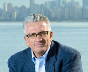 Jamie Peck, University of British Columbia
The 2020 AAG Distinguished Scholarship Award is awarded to Jamie Peck, for his foundational and sustained contributions to the field of economic geography and to human geography, more broadly.
It is difficult to overstate Jamie Peck’s intellectual influence. Peck is one of the most productive geographers of our time. He is in the top 1% of social scientists in terms of citations, with an h-index of 83 and more than 40,000 citations. His published work, which is notable for both methodological rigor and deep theoretical insight, includes 6 monographs, 13 edited volumes, 93 book chapters and 200 articles. Over three decades, he has published transformative work on the dynamics of neoliberalization, the economic transformation of urban governance, the history of economic geography, changing labor markets and regulation, and policy mobilities. His research has been funded by Canada’s Social Sciences and Humanities Research Council, the Ford Foundation, the U.S. National Science Foundation, and The Leverhulme Trust, among other sources. His many awards include the RGS-IBG Back Award and a Guggenheim, and he is a Fellow of the Academy of Sciences (UK), a Fellow of the Royal Society of Canada, and a Corresponding Fellow of the British Academy. One of the outstanding characteristics of his scholarship is his ability to frame complex problems in terms accessible to a broad audience. This is reflected in the reach of his work outside of the academy, as demonstrated by quotations and interviews in two dozen popular press outlets, including the Economist, the Guardian, the New York Times, and the Wall Street Journal.
Peck’s extraordinary scholarship is matched by an extraordinary record of service to the field as an editor and mentor. In his remarkable and ongoing run as editor at Antipode and Environment and Planning A, and now as lead editor of the five Environment and Planning journals, he has shaped the intellectual conversation across Human Geography for decades. Beyond his own editorial work, he is currently on the editorial or advisory boards of 11 other academic journals, and is a tireless reviewer for the top journals in geography and regional studies. Finally, through his deep intellectual generosity to junior colleagues and students, including as founder of the Summer Institute for Economic Geography and as advisor to graduate students and postdoctoral fellows, he has played a pivotal role in the development of generations of economic geography scholars. For these and his many other contributions to geography, Jamie Peck is the recipient of the 2020 AAG Distinguished Scholarship Award.
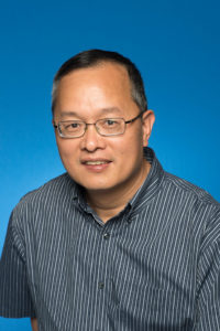
Qihao Weng, Indiana State University
Qihao Weng is a pioneer and leading scholar in the area of urban remote sensing. During his distinguished career, he has significantly advanced our theoretical understanding and empirical knowledge of urban heat islands and land surface temperature, urban sprawl, and environmental sustainability in the context of rapid urbanization. His originality, creativity, and significant intellectual contributions have resulted in 235 articles, 14 books, and funding support from NSF, NASA, USGS, NOAA, ESA, and the National Geographic Society. His academic record testifies to his history of innovative work and far reaching influence on a wide range of disciplines including urban geography, urban planning, landscape ecology, meteorology, and climatology.
Weng’s outstanding contributions to urban remote sensing and sustainability science include methodological innovations including novel algorithms and data analysis strategies and theoretical advances offering new perspectives on the urban environment and spatio-temporal aspects of urbanization processes. Taken together, Weng’s empirical and theoretical contributions have yielded significant new insights on some of the most critically important phenomenon influencing contemporary urban environments.
Weng’s seminal research on urban heat islands, landscape effects on land surface temperature, and urbanization processes opened a critical new frontier towards understanding and measuring novel environmental risks in rapidly growing urban regions. He developed a methodology for estimating land surface temperature with satellite-derived measures of vegetation that has become a core technique for those investigating urban climates. His research has also demonstrated that urban sprawl and warming are not an isolated phenomenon, but instead are coupled with other risk factors, such as infectious disease. His scholarship has not only transformed the scientific understanding of remote sensing in geographical applications, but also has bridged methodological gaps between geography, spatial ecology, and environmental science.
Beyond the considerable impact of his own research, Weng’s production of educational materials and resources have played an important role in training future generations of urban scholars in remote sensing and GIS techniques. In particular, Weng’s An Introduction to Contemporary Remote Sensing is the standard textbook for many introductory remote sensing courses and has been adopted by numerous universities, community colleges, and technical schools around the world. He also has a long record of dedicated professional service to the AAG. In recognition for his outstanding contributions to scholarship in geography, Weng has received many honors and awards including the AAG Outstanding Contributions Award in Remote Sensing (2011) and Willard and Ruby S. Miller Award (2015). In 2018, Weng was named a Fellow of the Institute of Electrical and Electronics Engineers (IEEE), Senior Fellow at NASA, and member of the European Union Academy of Sciences.
Weng’s research exemplifies the multifaceted scholarship that is critical in bridging contemporary urban studies with spatial ecology and environmental science. He also continues to be a role model for exemplary practices in education, public service, and professional leadership for the next generation of geographic leaders. For these reasons, the 2020 AAG Distinguished Scholarship Award is awarded to Qihao Weng.
2020 AAG Gilbert White Distinguished Public Service Honors
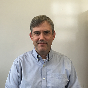 William Solecki, CUNY – Hunter College
The 2020 Gilbert White Distinguished Public Service Honors is awarded to William Solecki for his outstanding work to improve the human condition through direct community engagement, wide-ranging public service, and salient, cutting-edge research. Solecki’s work sits at the nexus of geographic inquiry, social justice, and environmental policy. His work has transformed our understanding of the opportunities and obstacles of urban living in a changing natural environment, and has been deeply influential across communities and organizations.
Of particular note is Solecki’s deft ability to work at multiple geographic scales among myriad organizations to advance our understanding of, and ability to respond effectively to, climate change. At a local scale, Solecki has co-chaired the New York City Panel on Climate Change, served as the Director of the CUNY Institute for Sustainable Cities, served as the interim Director of the Science and Resilience Institute @ Jamaica Bay, and led several climate impact studies in the greater New York and New Jersey region. At a national scale, Solecki served as the coordinating lead author for chapters in the 2014 (Chapter 11: Urban, Infrastructure, and Vulnerability) and 2018 (Chapter 18: Northeast) U.S. National Climate Assessment reports. Internationally, Solecki has been involved in Working Group II of the Intergovernmental Panel on Climate Change since 2006 and has made numerous contributions to the IPCC’s assessments of climate change impacts, vulnerability and adaptation for communities. He served as a contributing author for three chapters in the Fourth Assessment Report, as a lead author for the Urban Areas chapter in the Fifth Assessment Report, as a lead author for the Decision-Making Options for Managing Risk chapter in the Sixth Assessment Report, and as a coordinating lead author of the Framing and Context chapter of the IPCC Special Report Global Warming of 1.5oC.
In addition to his extensive scholarly research and many contributions to climate change assessments, Solecki is co-founder of the Urban Climate Change Research Network, co-editor of Current Opinion on Environmental Sustainability, and founding editor of the Journal of Extreme Events. He currently maintains numerous collaborative projects around the world. In 1975, Gilbert White wrote “that the human race is a family that has inherited a place on the earth in common, that its members have an obligation to work toward sharing it so that none is deprived of the elementary needs for life, and that all have a responsibility to leave it undegraded for those who follow (Stewardship of the Earth, p. 403-404). William Solecki is awarded the 2020 Gilbert White Distinguished Public Service Honors for his unfettered devotion to those basic principles and his ability to put them into action.
2020 Distinguished Teaching Honors
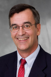
 Robert Lake, Rutgers University
Robert Lake, the recipient of the 2020 AAG Distinguished Teaching Honors, is an extraordinary educator and mentor of graduate students and young scholars. He has provided generous, sensitive and supportive teaching and guidance both inside and outside of the classroom. Lake’s goal has been to teach students how to think rather than what to think. His selfless mentorship has allowed students to grow and flourish intellectually.
At Rutgers University, Lake served as dissertation chair or committee member for over 130 doctoral students, many of whom are now leading scholars in urban geography and urban studies. He is well known for his innovative course design, particularly in the area of geographic theory, and his ability to convey to students his deep understanding of the research process. Moreover, he has contributed, through numerous administrative positions, to the structure and organization of graduate education from the department to the university level. Lake has been the recipient of multiple teaching awards inside and outside of Rutgers University.
Lake also has provided discipline-wide mentorship for graduate students and young scholars. As a long-term co-editor of the journal Urban Geography, Lake guided young scholars through the publication process. In his role as organizer of the annual AAG Urban Geography plenary lecture, he provided a forum for intellectual discourse and mentoring. Over the last two decades, Lake has organized the Brooklyn Urban Reading Group, an ongoing, open and inclusive discussion involving faculty and students from nearby universities.
Through his devotion to graduate education and the mentoring of young scholars, Lake has contributed to a network of scholars (affectionately referred to as Bob-net) who are continuing to strengthen the discipline of geography. In the words of a colleague and mentee, Robert Lake’s commitment to “pluralism, engagement, and deep care for others” makes him an exemplary educator and a role model for the discipline of geography.
2020 AAG Media Achievement Awar
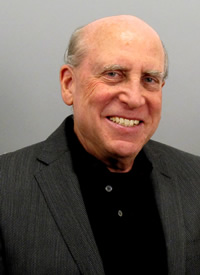
 Keith Debbage, University of North Carolina at Greensboro
Keith Debbage, recipient of the 2020 Media Achievement award, is a quintessential communicator of the scholarly ideas of applied urban and economic geography. His conceptual explorations run the gamut from local-scale planning issues, to regional examinations of economic decline and recovery, to the impacts of the so-called “Creative Class.” In every case, Debbage breaks the complexity down into jargon-free and readable packets of knowledge. Debbage draws on his scholarship, extensive professional service, including his appointment as a Coleman Foundation Fellow, and his lived experience when communicating with the public, such as in his recent columns on the power of local-scale entrepreneurialism and the role of higher education in the economic and cultural life of North Carolina. A disarming folksiness is underlain by decades of applied scholarship, much of it completed with external grant and contract funding.
As a role model for others, Debbage is prolific in his media presence and yet, by all accounts, seeks to share the spotlight with his student collaborators and to bring sophistication to his analyses even as they are accessible. From over a hundred newspaper columns, often against a backdrop of maps or graphics, to countless radio and television appearances, Debbage does the difficult work of communicating geographic scholarship to the public. For his consistent commitment to this important work, for repeatedly demonstrating that conceptual complexity doesn’t mean Geography has to be confined to the Ivory Tower, and for finding the right voice to bring Geography into the public sphere, Professor Keith Debbage is recognized with the 2020 American Association of Geographers Media Achievement Award.
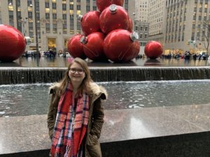
 Hannah Brenner is a senior at George Washington University pursuing a bachelor’s degree in geography with minors in sustainability and GIS. Hannah is interested in sustainable agriculture and how the way we grow our food affects people and the earth. She’s worked on farms around the world and has also earned her permaculture design degree. She believes that food is key to solving many of our worlds issues. Originally from North Carolina, she has made her home in DC and loves exploring the city. In her free time, Hannah likes to garden, cook, travel, and go on hikes around DC.
 Among the familiar litany of New Year’s resolutions, many of you may have promised yourselves that 2020 would be the year to finally finish that book or write that article. In other words: to PUBLISH.
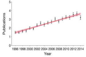
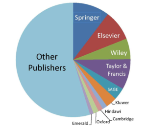