Regional Divisions Announce Outstanding Graduate Student Papers During their Fall Meetings

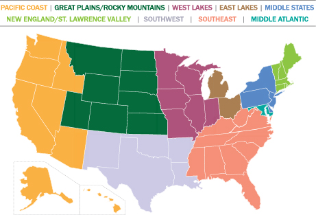
The AAG is proud to announce the Fall 2019 student winners of the AAG Council Award for Outstanding Graduate Student Paper at a Regional Meeting. The AAG Council Award for Outstanding Graduate Student Paper at a Regional Meeting is designed to encourage graduate student participation at AAG Regional Division conferences and support their attendance at AAG Annual Meetings. One graduate student in each AAG Regional Division receives this yearly award based on a paper submitted to their respective regional conference. The awardees receive $1,000 in funding for use towards their registration and travel costs to attend the AAG Annual Meeting. The board members from each region determine student award winners.

The winners from each region will be presenting their papers in two dedicated paper sessions at the upcoming 2020 AAG Annual Meeting in Denver, CO.

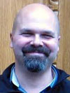
Matthew Walter (far left)

MSDAAG: Matthew Walter, Masters Student, University of Delaware; Paper title – A Rapidly Assessed Wetland Stress Index (RAWSI) Using Landsat 8 and Sentinel-1 Radar Data

GPRM: Cheyenne Sun Eagle, Masters Student, University of Kansas; Paper title – Spatial and Temporal Patterns of Land Allotment on the Pawnee Reservation

SWAAG: Katherina Kang, Masters Student, University of North Texas in the Department of Geography; Paper title – Vegetation and land use effects on the spatial distribution and accumulation of soil black carbon in an urban ecosystem

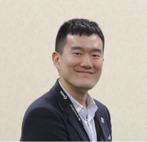
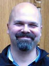
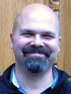
Junghwan Kim

WLDAAG: Junghwan Kim, Ph.D. Student, University of Illinois at Urbana-Champaign; Paper title – How Neighborhood Effect Averaging May Affect Assessment of Individual Exposures to Air Pollution: A Study of Individual Ozone Exposures in Los Angeles

ELDAAG: Rebekka Apardian, Ph.D. Student of Spatially Integrated Social Sciences, University of Toledo; Paper title – Exploring the Relationship Between Pedestrian Crashes and Walkability

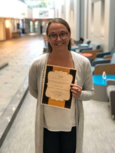
Michaela Garland

NESTVAL: Michaela Garland, Master’s Student, Southern Connecticut State University; Paper title – Evaluating, initiating, and incubating Blue Economy development – Case of the Long Island sound region

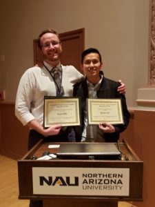
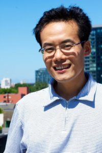
Dustin Tsai (on right)

APCG: Dustin Tsai, PhD candidate, University of California Davis; Paper title – A Tale of Two Croatias: How Club Football (Soccer) Teams Produce Regional Divides in Croatia’s National Identity

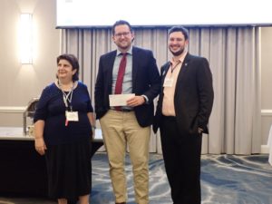
SEDAAG: Jordan Brasher, PhD candidate, University of Tennessee-Knoxville; Paper title – “Contesting the Confederacy: Mobile Memory and the Making of Black Geographies in Brazil”

Jordan Brasher (center)

MAD: Kelly J. Anderson, University of Maryland College Park, Middle Atlantic Division; Paper title – “Weather-related Influences on Rural-to-urban Migration: A Spectrum of Attribution in Beira, Mozambique”


    Share

Going Local or How the AAG Can Help Enhance its Regional Divisions

The region is one of geography’s main concepts and, true to these roots, regional divisions—mostly within the United States but many including Canadian provinces—developed as an intrinsic part of the American Association of Geographers. The Pacific Coast Division was formed in 1938 and the other regional divisions were established in the 1940s and 1950s. Preston James and Geoffrey Martin credit regions with much of the AAG’s growth during the 1960s, but what else would you expect from a geography organization? Regions are part of our DNA.

Today, regional divisions have distinct membership and governance structures. Several regions run their own journals; others have comprehensive websites and newsletters. And every region hosts a substantial one- or two-day meeting in the fall with field trips, keynotes, sessions, posters and prizes.

We differ in our approach to the AAG regions. Some geographers attend only the regional meetings; for them, these are the best part of the geography community. Others rarely interact with their region, focusing instead on the national meeting. And a few are active at both the regional and national levels. Despite being smack-dab in the middle of the West Lakes region, my graduate program at the University of Wisconsin–Madison had little to do with it, at least at that time. So I was only vaguely aware of regional divisions until I attended my first East Lakes meeting right after I started teaching at Kent State. I later served as division president and regional councilor.

Former presidents Kavita Pandit and Tom Baerwald have eloquently discussed some of the benefits of regions and regional meetings. These assets include a more intimate venue to contrast with the controlled chaos that is the national meeting, more opportunities to highlight geography to local politicians and businesses, the ability to show off geography to administrators, better interaction opportunities for undergrads and grads, lower costs, and more. When I attend regional conferences I notice that, with just two to four concurrent breakout sessions and fewer outside distractions, most sessions are quite well attended with ample questions and an opportunity for presenters to get their ideas across—something that is valued especially by students. And in this day of concern about carbon impacts of attending far-away conferences, regional meetings provide an option much closer to home.

My time as AAG vice president and president allows me to attend as many regional conferences as possible. I have glimpsed the culture of each region and I have enjoyed the vitality of the meetings. But my observations and discussions with regional leaders and meeting participants have also revealed some challenges. These often come in the form of varied attendance and engagement by members. At each regional meeting I attended, some schools were clearly involved whereas some significant programs were virtually absent. For graduate students looking to make contacts with scholars in their area of interest, or for undergraduates looking for information about different programs, such absences are frustrating. What may once have been a launching pad for grad students seeking to give their first paper is now ignored for a spot on the national program. Past president Audrey Kobayashi decried a “huge indifference to regional division activities across the country,” at least among some of the larger universities. This creates division; it creates a sense of abandonment. And frankly it means that the regions cannot function as well as they should. Past president Julie Winkler posed some important questions to ask about the regional meetings: How can the regional divisions strengthen geography at the national level? Is the attendance at regional division meetings proportional to the types of institutions in the region? What are some of the gaps that could be addressed?

So we must incentivize healthier regions and better regional meeting participation in order to bolster the AAG and geography as a whole. To that end, I established a task force—made up of members of each region—to understand some of the problems and point to potential solutions. Thus far, we have been asking regions a lot of questions, gathering information on various strengths and weaknesses, and then thinking of ways the AAG can assist. These suggestions come from the regions themselves and, if implemented, could considerably bump up the value of regional participation.

The first concerns are tied to regional governance. Quite plainly, many regions have difficulty finding enough willing leaders. Regions do not have professional staff and so governance and conference planning falls on the shoulders of volunteers. Some people feel that the recognition is not at all commensurate with the demands of this vital service. To this end, the AAG has pledged to provide more recognition for regional volunteers, enhance opportunities for regional officers to exchange ideas at the national convention and beyond, and perhaps waive the national meeting registration fees for division presidents or chairs.

Second, there is the question of how well the AAG might help with the management of the regions and their meetings. This September we sent out a survey asking if regional officers knew about all of the items the central office can manage: insurance, bookkeeping, a meeting registration license, Zoom account, childcare subsidy, and some others. The responses showed that not all of these services are universally known, yet they could save each region a big headache and some serious cash.

Finally, how might the AAG support and improve attendance at the regional meetings? In addition to the services listed above, we are committed to creating more incentives. We already established the AAG Council Award for Outstanding Graduate Student Paper at a Regional Meeting. This award of $1,000 that goes toward attendance at the national meeting is prestigious and profitable; I believe it has led to more students attending regional meetings. Other awards could be created—for outstanding undergraduate students or for faculty mentors who shepherd several students to regional meetings, for example. We could look at discounting the cost for students to participate in regional meetings. And for the regions themselves and for the hardworking people who put together a regional meeting, we are exploring various financial and non-financial areas of support. We will strive to establish more of an AAG presence at each meeting, going beyond the president giving the keynote. Perhaps most promising of all, there will be much more publicity for the regional meetings: at the annual spring meeting, on the AAG website, and on social media.

All these incentives must be matched with additional things that regions can do. The onus of putting together a regional meeting falls on just a few people. A manual of best practices, available to everybody, would be useful to see what has worked and what must be done and at what time. Another suggestion is to think about ways to combine a regional meeting with another meeting. Sometimes joint regional meetings can make a lot of sense. Other times, the meeting can be held concurrent with a specialty organization that attracts people from across the world. One promising avenue is to pair some of these meetings with a set of interested specialty groups. Could there be value in getting a dedicated geographical specialty conference that would share work, costs, and revenues with a regional division? This could create a bigger playing field.

Every region has a devoted core of people who participate in regional governance and regularly attend their fall meeting. But we can move beyond these mainstays to create a more robust level of participation: creating real incentives for people to work with their regions and to participate in regional meetings and making people feel that they and their students will obtain something of value at the regions which they cannot get elsewhere. These can be accomplished and, if they are, our regions will grow stronger and the American Association of Geographers as a whole will thrive.

— Dave Kaplan
AAG President

DOI: 10.14433/2017.0065

    Share

Call for chapter proposals: New AAG Book on Rocky Mountain West

One of the most anticipated items when I began attending AAG meetings was the annual edited book that came in our packet.  This would be a special volume dedicated to the city and region where the meeting was held.  Within it would be chapters detailing all kinds of interesting aspects of the region, written by geographers with expertise and wisdom.   I still have a large collection of these regional geographies on my book shelf.  The AAG was poorer when we stopped producing this regional compendium and we need to bring it back.

So I am delighted to announce that, for the first time since 2001, the American Association of Geographers will be introducing an edited book entitled Denver and the Rocky Mountain West.  It will be edited by Michael Keables, with an editorial board of local experts.

This will be a fully produced, peer reviewed book, available as a pdf to every conference attendee.  It can also be purchased as a spiral-bound copy for a small fee.

Consider this a call for chapter proposals for anyone who would like to contribute to the excitement of the Rocky Mountain region.  Consider this also a chance to provide all of our attendees with your unique insights about this region.

If you are interested in contributing to this new book, please contact Michael Keables at michael [dot] keables [at] du [dot] edu.  The timeline is short.  Mike will need a title and abstract by October 15.  Final submissions will be due by January 15.

— Dave Kaplan
AAG President

    Share

New Books: September 2019

Every month the AAG compiles a list of newly-published books in geography and related areas. Some are selected for review in the AAG Review of Books.

Publishers are welcome to send new volumes to the Editor-in-Chief (Kent Mathewson, Editor-in-Chief, AAG Review of BooksDepartment of Geography and Anthropology, Louisiana State University, Baton Rouge, LA 70803).

Anyone interested in reviewing these or other titles should also contact the Editor-in-Chief.

PLEASE NOTE: Due to current public health policies which have prompted the closing of most offices, we are unable to access incoming books at this time. We are working on a solution during this transition and will continue our new books processing as soon as we can. In the meantime, please feel free to peruse previous books from our archived lists.

 September 2019

Anthropos and the Material by Penny Harvey, Christian Krohn-Hansen and Knut G. Nustad (Duke University Press 2019)

Climate Machines, Fascist Drives, and Truthby William E. Connolly (Duke University Press 2019)

Connections and Content: Reflections on Netwoks and the History of Cartographyby Mark Monmonier (Esri Press 209)

Cyclescapes of the Unequal City: Bicycle Infrastructure and Uneven Developmentby John G. Stehlin (University of Minnesota Press 2019)

Enigmatic Stream: Industrial Landscapes of the Lower Mississippi Riverby Richard Sexton (University of Virginia Press 2019)

For the War Yet to come: Planning Beirut Frontiers by Hiba Bou Akar (Stanford University Press 2019)

Geography’s Quantitative Revolutions: Edward A. Ackerman and the Cold War Origins of Big Data by Elvin Wyly (West Virginia University Press 2019)

Ghetto: The History of a Wordby Daniel B. Schwartz (Harvard University Press 2019)

Home, Nature, and the Feminine Ideal: Geographies of the Interior and of Empireby Elaine Stratford (Rowman & Littlefield Publishers 2019)

Hungry Translations: Relearning the World through Radical Vulnerabilityby Richa Nagar (University of Illinois Press 2019)

Of Land, Bones and Money: Toward a South African Ecopoeticsby Emily McGiffin (University of Virginia Press 2019)

Savage Ecology: War and Geopolitics at the End of the Worldby Jairus Victor Grove (Duke University Press 2019)

Saving Grand Canyon: Dams, Deals, and a Noble Mythby Byron E. Pearson (University of Nevada Press 2019)

Sea Level Rise: A Slow Tsunami on America’s Shoresby Orrin H. Pilkey, Keith C. Pilkey (Duke University Press 2019)

The Seventh Heaven: Travels through Jewish Latin Americaby Ilan Stavans (University of Pittsburgh Press 2019)

This is not an Atlas: a Global Collection of Counter-Cartographiesby Kollektiv Orangotango (Columbia University Press 2019)

Trumpby Alain Badiou (Polity 2019)

Under Construction: Technologies of Development in Urban Ethiopiaby Daniel Mains (Duke University Press 2019)

    Share

John Webb

John Webb was born on 29 July 1926 in Staines, England, growing up west of London when World War II broke out. He joined the Royal Air Force during the war, but poor eyesight kept him from flying. Instead, he worked with RAF Intelligence drawing maps of Europe to be used for Allied bombing missions. After the war, he attended the University of St. Andrews, where he earned three master’s degrees in four years and met his first wife, Anne (Nancy) Smillie, an American.

Webb moved to the U.S. with Nancy in 1952, continuing his studies as a doctoral student in the Department of Geography at the University of Minnesota. He taught one year at the University of Maryland (1954-55) and returned to Minnesota an instructor (1955-58) while completing his doctorate with Jan Broek. After receiving his Ph.D. (1958) he taught in the Minnesota department, later serving administrative roles including associate dean for Social Sciences in the College of Liberal Arts (1969-73).

In 1979 Webb married Judith Holtan. They moved to Albany, New York, as he took the position of professor of geography and dean of the College of Social and Behavioral Sciences at the State University of New York (SUNY). He served in those positions until his retirement (1997).

His most notable publication (with Jan Broek) was A Geography of Mankind (1968), a pioneering college text organized by themes such as language, government, religion and economy as they appeared across the world. The structure of the text was a departure from the prevailing approach, which examined the map of the human world as a mosaic of regions and culture realms.

The year before Webb died, while he and his daughter Jennifer traveled to England, she learned that when he left RAF service he had absconded with some maps as keepsakes, including one, written in German and dated November 1940, which had been recovered by the Allies. It was a Nazi aerial map of Weybridge, Webb’s hometown and home to an important airfield and factory. The Germans had dropped some 500 bombs on the city over the course of the war. Although the Brits disguised and camouflaged the factory when war broke out, it could be seen clearly on the Nazi map.

The site of the former Weybridge airfield now has a museum where John and Jennifer donated the map some 78 years after it was created. It remains on display there. She recalled: “It was really neat because all the volunteers at the museum came and crowded around him and wanted to talk about it. …  It gave him some closure,” she said.

Following retirement from SUNY Albany, John and Judith eventually settled in St. Cloud, MN, where he died on 18 August 2019 at the age of 93. He was survived by his wife Judith, his daughter, Jennifer Fusaro and son John Webb.

    Share

New Books: August 2019

Every month the AAG compiles a list of newly-published books in geography and related areas. Some are selected for review in the AAG Review of Books.

Publishers are welcome to send new volumes to the Editor-in-Chief (Kent Mathewson, Editor-in-Chief, AAG Review of BooksDepartment of Geography and Anthropology, Louisiana State University, Baton Rouge, LA 70803).

Anyone interested in reviewing these or other titles should also contact the Editor-in-Chief.

PLEASE NOTE: Due to current public health policies which have prompted the closing of most offices, we are unable to access incoming books at this time. We are working on a solution during this transition and will continue our new books processing as soon as we can. In the meantime, please feel free to peruse previous books from our archived lists.

August 2019

Climate Machines, Fascist Drives, and Truth by William E. Connolly (Duke University Press 2019)

Culinary Nationalism in Asia by Michelle T. King, ed. (Bloomsbury Academic 2019)

Everyday Equalities: Making Multiculutres in Settler Colonial Cities by Ruth Fincher, Kurt Iveson, Helga Leitner, and Valerie Preston (University of Minnesota Press 2019)

Focus on Geodatabases: In ArcGIS Pro by David W. Allen (Esri Press 2019)

Food Values in Europe by Valeria Siniscalchi and Krista Harper, eds. (Bloomsbury Academic 2019)

GIS for Science: Applying Mapping and Spatial Analytics by Dawn J. Wright and Christian Harder, eds. (Esri Press 2019)

Globalizing the Caribbean: Political Economy, Social Change, and the Transnational Capitalist Classby Jeb Sprague (Temple University Press 2019)

Gods of the Upper Air: How a Circle of Renegade Anthropologists Reinvented Race, Sex, and Gender in the Twentieth Century by Charles King (Doubleday 2019)

Green Infrastructure: Map and Plan the Natural World with GIS by Karen E.Firehock, R. Andrew Walker (Esri Press 2019)

Human Geopolitics: States, Emigrants, and the Rise of Diaspora Institutionsby Alan Gamlen (Oxford University Press 2019)

Hydropolitics: The Itaipu Dam, Sovereignty, and the Engineering of Modern South Americaby Christine Folch (Princeton University Press 2019)

Imperial Metropolis: Los Angeles, Mexico, and the Borderlands of American Empire, 1865–1941 by Jessica M. Kim (University of North Carolina Press 2019)

Meat Planet: Artificial Flesh and the Future of Foodby Benjamin Aldes Wurgaft (University of California Press 2019)

Other Globes: Past and Peripheral Imaginations of Globalizationby Simon Ferdinand, Irene Villaescusa-Illán, and Esther Peeren, eds. (Palgrave Macmillan 2019)

Savage Ecology: War and Geopolitics at the End of the World by Jairus Victor Grove (Duke University Press 2019)

Spatial Histories of Radical Geography: North America and Beyondby Trevor J. Barnes and Eric Sheppard, eds. (Wiley-Blackwell 2019)

Taste, Politics, and Identities in Mexican Foodby Steffan Igor Ayora-Diaz, ed. (Bloomsbury Academic 2019)

The Age of Disruption: Technology and Madness in Computational Capitalism by Bernard Stiegler (Polity 2019)

The Battles of Germantown: Effective Public History in Americaby David W. Young (Temple University Press 2019)

The Book of Lost Saints by Daniel Jose Older (Imprint 2019)

The Emergence of National Food: The Dynamics of Food and Nationalismby Atsuko Ichijo, Venetia Johannes, Ronald Ranta, eds. (Bloomsbury Academic 2019)

The Poetics of Natural History by Christoph Irmscher (Rutgers University Press 2019)

Wilted: Pathogens, Chemicals, and the Fragile Future of the Strawberry Industry by Julie Guthman (University of California Press 2019)

Women and GIS: Mapping Their Storiesby Esri Press (Esri Press 2019)

    Share

Who’s sorting who? Or the explosion of metrics and how we can take back control

For those of us still working with paper student evaluations, we receive our spring semester results during the summer. It is a time of mixed emotions for many of us. While I heard one lucky young professor describe opening up her student evaluations as tantamount to Christmas, I am probably not alone in likening it to Halloween, where the tricks far outnumber the treats! Too hard, too boring, does not provide enough guidelines or makeup opportunities, not what I expected—the list goes on and on for the types of complaints students can and will make anonymously. As professors and grad students, we have seen them all.

I am at a point where these student evaluations mean little to my career. However there are plenty of instructors and junior professors—particularly those in precarious circumstances—who have to worry about each little bump and dip in their average. Colleges and universities, particularly those more oriented to teaching, rely on student evaluations to make tenure decisions. And less than super-positive evaluations can be used to bludgeon contingent faculty.

Student evaluations may have some place in assessment. There is no other way for students to provide anonymous feedback about a course or an instructor. However, the problems with this sort of measurement are legion. For one thing, research has repeatedly demonstrated that many students evaluate female instructors more harshly than male instructors (see the accompanying figure). Even the words that students use are different. Racial bias is also present, as is bias against foreign-born instructors. Nervous professors have figured out that the best way to receive more positive evaluations is to grade more generously. High grades are clearly correlated with good evaluations, though long-term studies have shown that students in courses given lower ratings learned as much if not more than students in courses with higher ratings. I remember an instructor who always plied students with pizza and cookies during evaluation day. Turns out, he was helping boost his evaluations significantly.

Summertime is also when many of us who work as journal editors receive an evaluation of another sort: the yearly impact factor. For those of you who have spent the last couple of decades in monastic solitude, a journal’s impact factor measures the mean number of citations each article garners over the course of a year. So an impact factor of 1 indicates that the average article during the measurement years attracted an average of one citation per year. The calculations can be done in several ways, and while it is not possible to bring pizza and cookies to all potential citers, there are still means of manipulating the process. For instance, some very unscrupulous journal editors will insist that accepted publications include recent citations to their very own journal.

As with student evaluations, journal impact factors have come to rise up and conquer all of academe. Originally meant for life science and medical journals, the impact factor now is used in all fields. The quality of one’s scholarship is also conveniently “measured” by the impact factors of journals that people list on their CVs. The numbers are easily grasped and can be a proxy for a journal’s research and scholarly reputation. I myself watched in dismay as journals I had long held up as models, both in and out of geography, were dismissed by their relatively low impact factors while some niche journals rapidly scrambled their way up the scholarly ladder. Even more dismaying is how these impact factors are used to box in scholars—rapidly quantifying and sorting what should be careful decisions. Taken to its extreme was a recent ad for a postdoctoral position in process engineering (gratefully, not in Geography), where applicants were required to have published in a journal with an impact factor above 10 or they “will get a rejection.” It is not as if impact factors suddenly became calculable; it is just that they became terribly urgent.

Journal impact factors have multiple biases. They favor journals composed largely of review essays or “debates.” They clearly slight some fields. For instance, only two journals in all of History rise above a journal impact factor of 1 and then just barely. Impact factors also screen out many varieties of scholarship, notably books. They can be “gamed” by editorial policy. And as I have found myself, a journal’s impact factor may ride on just one or two well-cited articles. Many new and innovative journals may not have an impact factor at all. To me the oddest thing of all is just how significant journal impact factors have become in an age where scarcely anybody physically handles an entire printed journal. Most of us download relevant articles, no matter what the journal. The well-known deficiencies of journal impact factors have sparked a strong backlash, culminating in the San Francisco Declaration on Research Assessment, which recommends that universities, potential funders, and publishers “not use journal-based metrics, such as Journal Impact Factors, as a surrogate measure of the quality of individual research articles, to assess an individual scientist’s contributions, or in hiring, promotion, or funding decisions.”

What is it about these measures? We have rankings of departments, of universities, and even of individuals. The United Kingdom has long undergone yearly research assessment exercises, and the state of Texas embarked several years ago on a program to evaluate the value added for every faculty member. Is this a needed corrective to professorial deadwood? Or is it yet another cudgel with which to intimidate and mold the professoriate?

Previous AAG presidents have weighed in on the explosion of metrics, while other academics on social media lament “the mushrooming of metrics and their influence on student, academic, and other university professionals’ lives.” My own view is that most metrics can be useful—after all, I employ them myself in research and evaluation. But they are inherently obtuse and contain all manner of biases. Because they are perceived as objective, they end up hiding their role in slighting certain groups and particular practices. Because they themselves become the desired objective, they lead to a warped process. Much like a company that only wants to maximize its quarterly earnings, too much reliance on metrics can lead to timid teaching and overly opportunistic scholarship. Exclusive use of these metrics cannot possibly account for all people do to forward the enterprise—the unplanned service, the approachable demeanor, the helpful hearing out of a student’s or colleague’s research ideas, the emotional labor—in other words, the soul of many a department and the types of things that should be valued more but are so egregiously overlooked.

So what can we do? For starters, it could help to work within your departments and institutions to ensure that teaching evaluations are used only within the appropriate safeguards, if they are used at all, with due respect to their inherent and discriminatory distortions. Beyond this, you can urge institutions and publishers you work with to join signatories to the San Francisco Declaration of Research Assessment as a way to scale back the reliance on misleading measures of research quality.

Professors like to say that we are not producing widgets, and I would agree. Many bemoan the corporatization of the academy. I agree with this as well. Metrics can be a form of empowerment as they provide alternative means of assessment outside the purely subjective. But they reduce a great deal of complexity to one simple and misleading number. Keeping our academic autonomy and retaining the purpose and dignity of our profession means putting these metrics in their place.

— Dave Kaplan
AAG President

DOI: 10.14433/2017.0057

* Gender Disparities in Student Evaluation Scores. Figure from Lisa Martin.

    Share

‘The Professional Geographer’ Welcomes New Editor

Heejun Chang. Photo credit: PSU-ISS.

This summer, the AAG journal The Professional Geographer will see a change in editorial leadership. Barney Warf has completed two terms as editor of The Professional Geographer and is succeeded by Heejun Chang, who assumed editorship of the journal on July 1, 2019.

Heejun Chang is a professor and outgoing chair of the department of geography at Portland State University. His publication record is extensive having published 131 peer-reviewed articles on topics related to hydrology, water resources, human modification of the environment, and environmental change, his areas of expertise. Heejun has experience with publication in a wide variety of journals, both disciplinary and interdisciplinary, and is regarded as a high quality peer reviewer, an accolade for which he received an excellent reviewer award from Journal of Hydrology. He has also served as guest editor for special issues of Climate and International Journal of Geo-Information.

Heejun’s vision for his term as editor of The Professional Geographer is one of diversity, inclusion, and innovation. He sees the journal as a premier location for bridging traditional divides among human, physical, and GIS scholarship and hopes to foster a balance in submissions from the various facets of the geographic discipline. Heejun believes that encouraging more cross-generational scholarship as well as manuscripts co-authored with practitioners will help to cultivate fresh ideas within the discipline and that The Professional Geographer can play a key role in circulating these debates. Lastly, as the AAG has become more international in its membership, Heejun welcomes scholarship from the global geography community including academics from the global south or whose primary language is not English.

The AAG would like to express their heartfelt thanks to Barney Warf for his hard work over the last eight and a half years. Under Barney’s editorship scholarship published in The Professional Geographer maintained high quality and rigor while engaging academics and practitioners worldwide.

The Professional Geographer, published four times a year, features a range in content and approach from rigorously analytic to broadly philosophical or prescriptive. The journal provides a forum for new ideas and alternative viewpoints.

    Share

Should we be worried? Or how to maintain and expand the number of geographers in our schools.

As geographers, we all know the value of geography. Right? It is a field that provides a unique perspective, an appreciation for particularity, an opportunity to synthesize. But as much as we affirm geography’s value to each other, we also need to look at how geography is perceived outside of our community.

In this regard, the last year or so has been sobering, at least for Geography in the United States. Geography degrees have been closed in some universities, including Boston University, whose Geography Ph.D. program did so well in the last National Research Council ratings. Geography has been threatened (but ultimately spared) at others, despite reorganization and faculty layoffs. Then, to add insult to injury, a recent report in Inside Higher Education (highlighting an even more precipitous drop in History) showed how the number of Geography majors had also declined in the last six years, falling about 7 percent. No matter our research excellence, our success in procuring funding, our prominence in public discussion – if geography loses its majors, the field as a whole is in peril. This was a point expressed many years ago in Ron Abler’s classic column “Five Steps to Oblivion.” Ignoring majors is a sure-fire path to program destruction and, as we know full well, we can never take geography’s position in the curriculum for granted.

So should we be worried? We should at least be guarded. The trends of major loss in the last few years are real, but there are other countervailing forces on which geographers should capitalize.
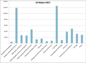
Compared to the other liberal arts, geography in the United States is a distinct underdog. We are the smallest of these traditional disciplines, just a bit under geology, physics and anthropology, and dwarfed by the likes of psychology and biology. Only 1 percent of all liberal arts majors specialize in geography. (By comparison, geography is squarely in the middle of the pack in the United Kingdom, comprising 5 percent of all liberal arts.) Geography has not been commonly taught in U.S. high schools. It is further hamstrung by its absence in most colleges and universities, relying on the larger state schools, some community colleges, a sprinkling of private colleges, and a very few private universities to provide the courses. Where geography is present, the departments tend to be small and most student majors arrive after their sophomore years.

Yet as a discipline, we punch far above our weight. Much of this is thanks to the AAG. Our membership of 12,500 rivals fields such as history, sociology, and political science. Our activities involve collaboration with geographers and other scientists around the world, many of whom look to American geography as a beacon, to the AAG as the one necessary organization, and to our annual meeting as the place to convene. About one-third of our membership is international, buoying our disciplinary footprint. Other strong organizations, like the American Geographical Society, the National Council for Geographic Education, and the Society of Women Geographers also help lay a foundation for geography outside the academy and in the schools.

A closer examination of the major numbers in the United States also shows that our recent decline may be a short-term phenomenon. Between 2007 and 2013, the number of geography majors grew 22 percent, and even with the decline in the last four years, we are still up nearly 10 percent over the last decade. But we may still look at how these recent trends could be reversed — a project that could involve seeing where the declines were sharpest and identifying possible areas of growth. (Liberal Arts as a whole has also suffered small declines). That we are in a better position in regard to majors than we were 11 years ago is a positive sign, but still worrisome.

One very encouraging sign is in the expansion of some of geography’s closest cognates — fields like meteorology, environmental studies, area studies, and the like. These are fields commonly folded within geography departments and so almost always can count as a “geography” major. The table below shows the most important of these:
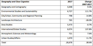
Pursuing such strategies entails the teaching of geography by other means. Students want geographical knowledge, they gain this by taking classes in these close cognates — often with geography professors — and they come out with much greater exposure to geography than would have otherwise been the case. Some of these incorporations may be acknowledged by renaming and Five Steps to Oblivion; other times the department may keep its name and just promote its diversity of offerings. To be sure, some of the traditional quasi-geographical specializations such as landscape architecture and area studies have declined. But there has been an explosion in environmental studies and global studies, with more modest growth in some of the other close cognates. If geography departments can capture those majors, the path toward sustainability becomes much clearer. At my department for instance, we were able to create an environmental studies major precisely because there was nothing like this available on campus. As a result, we have tripled our “geography” major numbers within the last two years. Other departments may pursue other strategies. Middle Tennessee State University, for instance, has a vibrant Global Studies major.

The last point I want to make also has potential to be the greatest opportunity. Since its inception, the Advanced Placement Human Geography high school course has exploded. Thanks to geographers like past President Alec Murphy, David Lanegran, and others, we were able to create this AP course in the 1990s and it has continued to defy all expectations. Out of the 38 AP exams given, AP Human Geography ranks in 10th place. (Environmental Science ranks 13th). The most striking aspect is its growth. Human Geography has grown by about 450% since 2008, far ahead of any other subject. And all signs indicate that this expansion will continue, as AP Human moves into other parts of the country.

Unfortunately, this phenomenal growth has yet to translate into major gains in college majors. AP courses/tests should make a positive difference in later specialization. Whether they just confirm existing intentions or open up new possibilities is still in question. But some worry that they end up eating into introductory course offerings. But there can be no doubt that this is a city-sized opportunity available to us. We need to devise ways as a discipline to turn these high school learners into college majors. The AP Human Geography exam and other AP possibilities will be the subject for a future column.

So despite some reason to worry, longer-term trends in the last decade are still positive, some of our closest cognates are growing briskly, and the expansion of AP Human Geography has been nothing short of phenomenal. The long-term health of the discipline is not assured, but it is within reach. We must exploit our advantages.

If you have gotten this far, let me extend my gratitude to all of you for giving me the chance to serve as president of the American Association of Geographers. I am humbled in succeeding people like Glen MacDonald, Derek Alderman, and Sheryl Luzzadder-Beach, not to mention all the luminaries who served before them. I look on these columns as an opportunity to shine light into some of the various features and problems of our discipline. Among these will be columns on creating a more inclusive academic culture, the internationalization of the AAG, the explosion of metrics in our discipline, publishing paradoxes, encouraging great writing, managing mental health, promoting opportunities beyond academia, and rethinking the regions. I hope that each column helps to further a dialogue, as there are rarely easy answers. We just need to keep trying. Please email me at dkaplan [at] kent [dot] edu with your thoughts.

— Dave

DOI: 10.14433/2017.0056

Source for this data comes from IPEDS Access Database for Integrated Postsecondary Education Data (IPEDS) Collection, https://nces.ed.gov/ipeds.

    Share

Carlos Saavedra

Education: Masters Certificate in IT Project Management (Georgetown University), B.S. in Computer Science (University of Sacred Heart, Puerto Rico)

Who is your current employer and what is your job title?
I retired from the federal government about four years ago. Right now, I am a volunteer, and I help nonprofit organizations with their IT and GIS needs. I am helping the Boy Scouts of America at the National and council level, making maps. I am also in a group called Dallas GiveCamp that brings nonprofits together for one weekend to help them create programs and software that they can use, because most of the time they don’t have the resources to do that. I bring in my GIS skills and provide them with the ability to make maps.

For example, I have helped the Turtle Conservancy organization in Florida. They have several turtles around the world with a tracking device on them.  I have taken the coordinates from the satellite and then put them in a map, so the public can see where those turtles have been throughout their life. Last year, I worked with “Water for Life” in Haiti. I kept track of where they had distributed water filters to families, and taught them how to use the software so they can continue with their mission. The other effort that I’m very involved in today is making maps, working with FEMA in regards to Hurricane Maria disaster relief in Puerto Rico and Puerto Rico Rises.

What knowledge have you found, in your past education and training, to be important substantively?
Before doing GIS, I used to work as a civilian for the Army in San Francisco as a Computer Programmer Analyst. After that, I worked for the United States Postal Service, in the Data Center in San Mateo as a Computer Systems Analyst/Programmer Sr. My last job was with the Social Security Administration in the Regional Office in Dallas, where I was an IT Project Manager Director, IT Supervisor, Program/Management Analyst, and IT Specialist. In that job during my last 6 or 7 years, I became one of the GIS experts in the agency as I was one of the first analysts to use this technology in the SSA at a national level. Because of my skillset, I was able to pivot from one area to another very easily.

What allowed you to pivot, in terms of some of your coursework or training beyond GIS?
Before I started GIS, I was an IT professional. I started teaching myself GIS, and I went to a formal training and that is when the floodgates opened.

What drew you to GIS?
At the time, I was working for the Social Security Administration. I was looking for other ways to visualize data and I came across this technology. I did my first map, showed it to my managers, and they were impressed. From that point on, I started investing more and more time testing mapping tools. SSA gave me the tools, training and flexibility to work with this technology.

The first “a-ha” moment for me was after I took my first GIS class. I went to San Diego and I remember the teacher was teaching the class and I kept asking questions. I started making a list of all the things that I could accomplish with GIS to help my agency. Right after I finished the class, Hurricane Katrina happened. I did a lot of maps for SSA that had to do with Katrina. The other moment came when I was asked to realign ZIP codes assigned to Social Security offices in each region. That’s when the floodgates pretty much opened.

It was very challenging being among the first in the agency working with this new technology, but I had a great Regional Commissioner and Director who supported me. I got to go to a lot of high-level meetings and conferences and gave presentations to SSA executives and commissioners about GIS. Basically, I was teaching them what GIS was and how it applies to the SSA, using real-life examples.

Could you provide some of these specific examples?
In the Social Security Administration, we have what is called “e-services”, a way for the public to engage with the agency via the internet. I created a map in order to market this initiative to the public. I used demographic and SSA data to data mine age groups, gender, economical status, race, and location. So, in a concrete way we were working on a project that was for the beneficiaries, the people who were receiving money from us to use SSA checking accounts, instead of us mailing that check to them. I came up with a formula that if you make over $55,000 dollars, it’s very likely that you have a checking account. We targeted the ZIP codes to market the e-services into specific areas, instead of the whole nation.

Another example involves natural disasters. The SSA is focused on people who receive financial assistance when disaster happens. So, we have to know when the disaster is coming. With a hurricane, for example, you kind of know when it’s coming and then prepare for the event. In fact, in Texas, a lot of times we delivered the checks ahead of time so the people could have the checks before the hurricane. This is a massive undertaking. In other instances, we have to find ways to distribute the money to these people. During Katrina, we created this kind of debit card. We would put money on the debit cards and distribute them. We also did this in the West Texas explosion, in the Oklahoma tornadoes, in the hurricanes in Texas, Louisiana, Florida, Puerto Rico, the east coast, and also the tsunami in American Samoa. When the tsunami happened there, I was able to connect with people in American Samoa, and use a map to understand the damages that we were dealing with. Our executives and commissioners in Baltimore were able to see those things and take appropriate action.

Could you talk a little bit about, on a personal level, how GIS connects with your aspirations in your volunteer activities and your sense of civic engagement or responsibility?
Technology impacts us in a positive way and touches almost everything that we are involved in, be it in our lives or in society. You can find a GIS application that can help practically anything. You don’t need to be a GIS or IT/technical person to use this technology, because Esri has made it so easy that you don’t need to have those skills. You can create stuff that maybe a few years back was something that you needed to have an IT person and all of these skills to do. You can visualize data in a map, and I have noticed that when you do that it improves the way you make your decisions.

Now that I am retired, the most fulfilling thing is that I can share how GIS works and educate non-profit organizations on how this tool can change the way they do business. I also tell them that you don’t need a lot of money, you can do it for free. Specifically, in Puerto Rico with the hurricanes, you can still use GIS even when you don’t have an internet connection, and when you get to a place where they have an internet connection, you can sync with the world.

    Share