A Student’s Guide to the AAG Annual Meeting

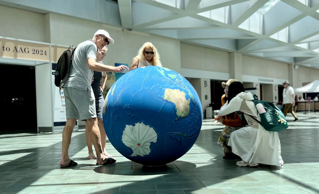
AAG annual meeting attendees interact with AAG's giant inflatable globe during a break in the conference.

Attending an annual conference can be confusing and intimidating; regardless of whether you’re a first-time undergraduate attendee or a seasoned postgraduate student. At AAG, we want to do what we can to provide you with advice to cover all aspects of the Annual Meeting. Although this isn’t a comprehensive checklist, here are some tips and tricks to make the experience as seamless and enjoyable as possible.

Preparing for the Meeting

Travel, Lodging, and Packing

There are many factors to consider in deciding where to stay, including cost, proximity to the meeting venue, and desired experience (e.g. access to a kitchen, neighborhood vs. downtown, ability to share accommodations). Different kinds of lodging offer different advantages: the conference hotel, nearby hotels, or an option such as AirBnB or VRBO. However, AAG does reserve discounted rooms in a nearby conference hotel at each annual meeting. Understandably, attendees will seek the best deal for lodging. Students can pool their expenses together and stay in accommodations with each other.

Note details about the local airport or train station you’ll be arriving in, and public transportation options. AAG tries to select conference locations that are walkable, with good public transportation, and we share what we learn about local transportation options in our conference information.

If it’s your first time attending a conference, consider this packing list from Rebecca Rice, author of PhD in Clothes, who provides guidance about work-life balance, professionalism, authenticity and style on the academic career path.  Make sure to pack shoes for easy walking—you’ll be doing a lot of walking even just inside the conference center. Think about the field trips and excursions you’d like to do, and pack shoes and outerwear for them.

Building your presentation

Whether you’re presenting a paper, poster, or attending a panel discussion, start building your presentation early. Ideally, working with a mentor can help you tailor your presentation to communicate the necessary findings and next steps of your work. You may also consider asking your department faculty and staff about their experiences attending past academic conferences. Seasoned attendees often have secret hacks or insight gained from first-hand experience.

If you are presenting, host a small social practice session with fellow students and faculty. This will allow you to time the presentation to keep within the allotted limit and to practice without a script. A practice session can also present opportunities for your colleagues to provide feedback or propose possible questions the audience is curious about.

It’s important to note that presenting is not required; If you’re an undergraduate, attending a conference gives you the opportunity to hear a wider variety of viewpoints, and can help in giving you a better impression of the discipline as a whole.

Review the Program

The AAG Annual Meeting program will be released about a month before the start of the conference. Take advantage of the available information to plan out your daily schedule by checking out familiar names, sessions related to your interests and research or abstracts which sound interesting to you.

To one side of the online program (the right side in 2025), you can refine your search by session type, modality, sponsor groups, or a curated track, which is a compilation of sessions put together with a common theme or goal. From special sessions and workshops to networking events, you can find every event listed in the program. Don’t forget to download the AAG Meeting app to keep up-to-date on the latest changes of events, reminders, and meeting information. Consult our tip sheet for quick set-up and user guidance or delve more deeply into the functions of the app with our user guide.

Attending the Conference

Check In

When planning your trip, typically plan to arrive at the conference the day before it starts. AAG’s on-site registration will open the afternoon before the first day of the event, so you will be able to go to the venue and check in to collect your name badge. It’s crucial to wear your badge when attending any event affiliated with the meeting. This will often be your first introduction to and from other attendees as you familiarize yourself with others.

Day-by-Day

With a day long schedule, it’s recommended to dress comfortably, bring a water bottle, and a snack. With numerous keynote speakers, workshops, and panel discussions constantly ongoing, the meeting will feel hectic and confusing. Embrace the experience! Narrow in on sessions that call out to you and take the time to gain insights from presenters in your research niche. Engage in Q&A sessions, introduce yourself to other students, and don’t be afraid to ask for advice.

Networking doesn’t come easy, but with practice, it will come naturally over time. Students may take the time to prepare business cards and a brief elevator pitch about research interests or future goals. Get in touch with university professors and other students to start building a network of acquittances. Here are annual events that offer these opportunities. The best way to find these sessions are to filter the program by “AAG Events.”

  • Welcome Reception—The reception takes place on the first evening of the conference with drinks, bites, and space to mingle with other attendees.
  • Plenaries, Award Sessions, and Panels—With more than 1,000 sessions to choose from, it’s easy to get overwhelmed. AAG has several special types of sessions you can seek out in the program, from the special events to numerous awards sessions and plenary panels hosted by AAG Specialty groups.
  • World Geography Bowl—An AAG tradition is the World Geography Bowl, a fun, often fast-paced competition of student teams from AAG Regional Divisions. It’s a great opportunity to cheer on your peers, learn a few new things about geography, and mingle with other students.
  • Careers and Professional Development Center—Each year, AAG features a large track of over 50 panels, paper sessions, workshops, and networking events focused on career preparation and professional development for geographers. These sessions and events will take place throughout the entire conference in the Careers & Professional Development Center, a central hub for students, early-career professionals, job seekers, and other attendees to network and learn from professional geographers and develop strategies for finding employment in geography-related occupations.
  • Student Day—In addition to specialized offerings for students throughout the entire week, AAG works with student members to organize a full day of sessions dedicated to student research, methods training workshops, career planning & mentoring, and networking events and activities for students at all levels of higher education. Keep an eye out for the curated track and create your own schedule year after year.
  • Specialty and Affinity Group Business Meetings—AAG’s more than 75 specialty and affinity groups all have business meetings during the annual meeting. These meetings are usually small gatherings that provide excellent opportunities for you to discover an interesting community of your own—or several. The meetings are open to all AAG 2025 participants, and in fact many specialty and affinity groups see their business meetings as an important way to engage and recruit new members.

Conquer Your Fear of Missing Out

Take a break! Explore the area! It’s likely you won’t have time to attend everything you planned, and you may even skip an event you had slotted into your schedule to keep yourself from getting worn out. Many attendees are travelling from out of town, so this is an opportunity to connect with our host city. Specialty and Affinity Groups often organize field visits that align with their core interests that venture out to local neighborhoods, historical sites, or a hands-on engagement project. During the registration process, you can choose the workshops and field trips you’d like to participate in. If you are already registered, simply click the Register Now button on our website to access your registration and add events.

The Follow Up

Reflection and Outreach

As you travel home, take a moment to collect your thoughts. Make note of any interesting papers or suggested readings, save all contact details business cards, or make note of any plenaries that inspired you.

Remember our networking events? Follow up with new contacts after the conference to maintain relationships and explore potential collaborations. LinkedIn is a great way to maintain professional relationships as a network grows.

Take Advantage of AAG Resources

With your student membership, you can join a number of Affinity Groups or Specialty Groups that align with your research interests and stage of education. Specifically, the Community College, Undergraduate Student, and Graduate Student affinity groups strive to enhance the participation and representation of students within the organization and better prepare students for further study and careers in geography. Additionally, connecting with one of your nine Regional Divisions allows you to network with geographers and other members in an area located near you. Held annually each fall, Regional Division Meetings empower AAG members to connect around regional issues of significant importance.

Your membership also grants access to the AAG Job Board. If you’re looking to start your career in geography or transition to a new field or position, members can view hundreds of open positions from a variety of employers, upload a resume to help employers find you, and sign up for job alerts to be the first notified of open positions relevant to your job search or interest. If you’re looking to advance your education, explore our Guide to Geography Programs and Opportunities to take the important step to understand the different academic opportunities and how they align with your goals.

Read more about student resources
    Share

Sowing the Seeds for Food Sovereignty in Detroit

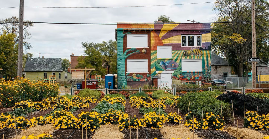
An urban farm plot of beds with crops and flowers sits in front of a building painted with an artistic mural, courtesy Michigan Urban Farming Initiative - MUFI
Photo courtesy Michigan Urban Farming Initiative (MUFI)

Urban agriculture is blossoming in Detroit, gaining recognition for its “green revolution,” through the rise of urban gardens and farms. With a total of 139 square miles or over 100,000 empty lots being vacant, this provides an opportunity to incorporate green spaces into communities throughout the city.

Urban gardening isn’t new to Detroiters. During the economic crisis of 1893, “Potato patches” helped feed hungry families and taught people how to grow their own food during times of social and economic crises. Later, in the 1970s, Mayor Coleman Young’s “Farm a Lot” program set an ambitious goal of transforming 3,000 empty lots into urban gardens. In the late 1960s the Black Panther party served breakfast to children in Black communities — highlighting the racialized gaps in funding from the United States government. The connections among community, mutual aid, and growing and providing food go far back in Detroit. Rather than working against each other, cooperatives and mutual aid programs ensure that groups can pull resources together to beat the system at its own game.

Detroit’s history of gardening, farming, and giving to neighbors shows how communities can move beyond food justice and into food sovereignty. Food justice addresses hunger at a basic level; food sovereignty takes it up a level to define, own, and dictate a food system. This in turn provides the earth with increased resilience to crises and climate impacts, in addition to promoting autonomy for communities. According to shakara tyler, co-executive director of the Detroit Black Community Food Sovereignty Network, part of creating a just society and systems means, “shifting from extractive economy and reinvesting into the regenerative economy.”

The growth of urban agriculture in Detroit is a testament to the resilience and innovation of its people. Initiatives such as the Oakland Avenue Urban Farm and Detroit Black Community Food Sovereignty Network are prime examples of how community-based organizations can catalyze change, serving as educational platforms for sustainable living. Explore gardens and organizations below to see how modern food sovereignty is inspiring Detroiters to create a deep praxis within other justice movements across local and state-wide levels.

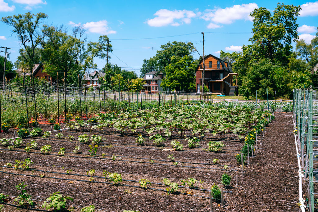
View of plants growing in beds in an urban garden plot in Detroit, Michigan
Urban garden plot in Detroit, MI


Michigan Urban Farming Initiative

7432 Brush St, Detroit, MI 48202

Based in Detroit’s North End community, Michigan Urban Farming Initiative’s (MUFI) redevelopment of a three-acre area in Detroit’s North End, is being positioned as an “epicenter of urban agriculture.” With the goal of creating a sustainable “agrihood” with multiple projects, the campus is divided into thirds: production farming, interactive agriculture, and hardscaped spaces, such as their Community Resource Center. Since operating out of their new headquarters, MUFI has been able to grow and distribute over 50,000 pounds of produce (grown using organic methods) to over 2,000 households within 2-square miles at no cost to the recipients.

Oakland Avenue Urban Farm

9227 Goodwin St, Detroit, MI 48211

Operating out of Detroit’s North End neighborhood since 2010, the Oakland Avenue Urban Farm (OAUF) is “cultivating healthy foods, jobs, and active cultural spaces.” The “Farm” grows over 33 varieties of vegetables and fruits and operates a “Harvest on Demand” option with local farmers markets, allowing neighbors to have consistent access to produce. In addition to partnering with local chefs and nonprofits to distribute tens of thousands of hot meals across the city, OAUF provides training opportunities, manages a community land trust, and brings together youth to improve learning and leadership skills.

Keep Growing Detroit

1445 Adelaide St, Detroit, MI 48207

Keep Growing Detroit (KGD) is working to cultivate a food sovereign city where the majority of fruits and vegetables consumed by Detroiters are grown by residents within the city’s limits. Their Garden Resource Program (GRP) supports urban gardening in the city by providing high-quality resources to family, community, school, and market gardens located in Detroit, Highland Park, and Hamtramck. Participants receive seeds, transplants, personalized garden assistance from staff, and a connection to an incredible network of gardeners, farmers, and advocates for a thriving food system across the city.

Detroit Black Community Food Sovereignty Network

11000 W Mcnichols Rd Ste 103, Detroit, MI 48221

Another non-profit that aims to amplify and create sustainable and equitable food systems is the Detroit Black Community Food Sovereignty Network (DBCFSN). The 7-acre urban “D-Town Farm” grows more than 36 different fruits, vegetables, and herbs with cultural and social significance, with the intention of farming what people want to eat and in high demand. Their work to shift the understanding of food, is a way to have sovereignty and learn about the importance of these systems. In addition to providing security, DBCFSN co-founded the Detroit Black Farmer Land Fund with KGD and OAUF to support rebuilding black land wealth. Since 2020, over 239 awards have been made to residents, businesses, and organizations.

North End Agri-Arts Alley

Currently under-going construction

In March 2023, the city announced four new Arts Alley locations in North End, Detroit. Specifically, the North End Alley will be the first Agri-Arts alley as part of a federal grant to transform dilapidated alleys into artistic oases. Anchored by the Oakland Avenue Urban Farm in partnership with artists from the Oakland Avenue Artists Coalition, this green alley will complement the Oakland Avenue Farmer’s Market, North End Resource Center, Oakland Avenue Cooperative Greenhouse, and Black Bottom Garden Center. Major construction is currently underway and is expected to be completed in late Spring 2025.

Urban farms and gardens are not just places to grow food; they are hubs of community activity, education, and empowerment. While the challenge remains to make these green spaces accessible to all, efforts are being made by the city to provide urban agriculture government guidance and infrastructure. In September 2023, the city of Detroit named Tepfirah Rushdan, former co-director of Keep Growing Detroit, its first director of Urban Agriculture. Over the past decade, the movement has seen substantial growth, transitioning from a few community gardens to a network of over 2,00 gardens and farms engaging nearly 20,000 Detroiters as of 2023.


Watch the webinar recording “Building Black Food Sovereignty in Detroit,” featuring shakara tyler, as part of our Preparing for the Detroit 2025 Annual Meeting webinar series.

You can register for the 2025 Annual Meeting field visit “Feeding a City: The Geography of Urban Food Systems” hosted by the Food and Agriculture Specialty Group to further explore Detroit’s urban food system landscapes.

    Share

Program staff at the National Science Foundation’s Human Environment and Geographic Sciences have been terminated

    Share

A Message of Hope and Action

Person holding their hands in the shape of a heart with sunlight in background

By Risha RaQuelle, Chief Strategy Officer

Photo of Risha Berry

In these times of rapid change, connection and community matter more than ever. AAG stands firm in our commitment to support and uplift our members, providing access to our member networks—networks necessary to navigate an evolving landscape. Through strategic planning, member-led initiatives, and resource development, we are building a future that reflects the resilience, creativity, and strength of geographers everywhere.

Together, we will sustain a thriving community where members can connect, contribute, and succeed—driven by the power of collective care and hope.

Charting a Bold New Course

AAG is actively preparing in collaboration with Council a new 10-year strategic plan and two staff-led 5-year operational plans to align organizational goals with the evolving needs of our members. These plans build on the strengths of our past while advancing a sustainable and forward-thinking agenda.

Members will play an essential role in shaping the 10-year plan. We invite all members to participate in upcoming listening sessions at the Annual Meeting. Your voice and perspectives will be key to ensuring that this plan reflects the collective needs and aspirations of our community

Our vision for growth

Forecasted last year, through our Request for Research Partnerships initiative, our vision for growth will continue to center member-driven grant partnerships to provide essential resources for meaningful work and programs. By investing in our members and fostering new networks of support, we are laying a foundation that sustains innovation and community engagement for years to come.

AAG’s renewed focus on connectivity is embodied in Communities@AAG, a newly aligned  organizational framework designed to enhance collaboration and resource-sharing across Specialty Groups, Affinity Groups, Communities of Practice, and Regional Divisions. This approach elevates community-driven programming and resource development through strategic grant seeking and member engagement.

Communities@AAG: Enhancing Connectivity and Collaboration

Communities@AAG represents a strategic organizational realignment that fosters networks of care, empowering geographers at every stage of their careers to connect, belong, and thrive. It is evolving into an all-hands approach by AAG staff, led by two key roles for AAG staff members dedicated to advancing this mission:

  • Community Impact Coordinator: (Eddie McInerney) Strengthens collaboration among member groups, including the 75 specialty and affinity groups, to foster equitable practices, share resources, and enhance member engagement. Eddie also monitors engagement opportunities around issues of importance to AAG members, in keeping with our Policy Principles.
  • Manager for Career Programs and Disciplinary Research (Mark Revell): Oversees professional development and research initiatives that align with AAG’s strategic goals, including expanding professional development offerings at the annual meeting, delivering comprehensive educational programming year-round, and enhancing AAG’s learning resources and disciplinary information to support students, professionals, and departments through essential services such as the Healthy Departments Initiative, Jobs Board and Guide to Geography Programs.

Building on Past Achievements

As we chart this new course, we are also reflecting on past efforts to ensure continuous improvement. In recent years, AAG has been developing leadership cohorts, improving our operations, piloting new programming formats, and refining community engagement strategies to be ready to support our members.

By partnering with members on efforts like Healthy Departments, the annual Geography Faculty Development Alliance workshops for both early career support and leadership development, and projects such as the Convening of Care and GAIA, we are creating sustainable pathways for innovative programming, professional development, and research. This approach ensures that our work is driven by and responsive to the needs of our membership.

We look forward to hearing from you. Join us at the listening sessions during the Annual Meeting and reach out to our Communities@AAG team to connect and get involved!

The AAG Culture of Care column is an outreach initiative by the AAG JEDI Committee. Don’t forget to sign up for JEDI Office Hours. The current theme of Office Hours is An Ethos of Care in the Research Enterprise.

    Share

The Power and Synergy of Imagery and GIS

Russell G. Congalton

Black-and-white analog aerial photo of University of New Hampshire campus; Courtesy: Eastern Topographics, Wolfboro, NH
This photo is a black and white, analog aerial photograph of the University of New Hampshire campus taken on April 14, 2014. Courtesy Eastern Topographics, Wolfboro, NH

In the beginning there was the aerial photograph. Initially, only in black and white, but soon along came color to really brighten things up. So much information could be gleaned from these photographs without having to travel to sites yourself.  Not only could a viewer tell what the current conditions of the area were, but they could compare the area  to previous photos and see what changed. Then color infrared film was invented, giving us the ability to see in a wavelength of electromagnetic energy beyond what our eyes could see. The possibilities were endless. Applications included urban planning, crop monitoring, forest characterization, water quality analysis, and disaster relief among many others.

While photographs taken with film were very powerful, images acquired digitally using a sensor system or a camera were even more so. Satellites were launched that imaged the earth repeatedly and regularly. Initially, these images did not have the same amount of detail (spatial resolution) as the analog photographs, but that quickly changed, and today film is all but obsolete. In addition, these digital sensors have the ability to record in wavelengths beyond what our eyes can see including near infrared, middle infrared, and thermal.

Having a steady source of information generated from remotely sensed imagery about our planet is invaluable. However, could this information be improved? The answer is yes; through geographic information systems (GIS). A GIS allows the user to put together various sources of information by layering the data layers on top of each other to tease out even more information and help in the decision-making process. For example, a university planner may want to determine the best place to build a new campus parking lot. They might download a general land cover/vegetation map (National Land Cover Data from the USGS) that was created from Landsat imagery. Then they might obtain a slope and aspect data layer (also from the USGS generated from remotely sensed imagery). A map of soil types (especially hydric or wetland soils) could be gotten from the Natural Resource Conservation Service (this information was also generated from remote sensing). Finally, the university probably already has a detailed campus map with building footprints and other infrastructure (utilities, pipelines, roads, etc.). An analyst could then use a GIS overlay all these various data sets on top of each other to determine the best candidate locations to build the new parking lot. The decision-makers could specify the criteria they want for the new parking lot. For example, they could say that they want the lot placed on relatively flat land, within 10 minutes walking distance of the central campus, near a central access road, not on a wetland, and where no forest land needed to be disturbed. The GIS could perform this analysis digitally and provide potential locations that meet these criteria. The decision-makers could, if they chose, revise their criteria and quickly get a different set of potential locations.

This figure demonstrates one of the powerful abilities of a GIS to overlay various data layers (many generated from remote sensing) to ask questions such as the optimal place to put in a new parking lot on the University of New Hampshire campus. Courtesy Russell G. Congalton


Clearly, GIS is a powerful tool that has become ubiquitous in our society. Farmers, business developers, politicians, law enforcement, natural resource managers, emergency management agencies, real estate agents, community planners and almost everyone else either uses a GIS or the information generated from one. However, it is important to not lose sight of the source of the vast majority of information input into the GIS. Imagery/remote sensing is the source of many of our GIS data layers. Therefore, a GIS analyst should be aware of the basics of remote sensing so that they not only have an appreciation of how the layers are created, but also so that some evaluation of data quality or accuracy is possible. There is an old adage that is appropriate here; garbage in means garbage out (GIGO). If the GIS user is either unaware of how the data they are using has been created or is using that data in an incorrect/inappropriate manner, then the decisions made with that data could be seriously flawed.

The synergy between imagery/remote sensing and GIS is obvious and undeniable. GIS is highly dependent on having timely and accurate data layers (most generated from remote sensing) to produce effective decisions. The GIS analyst is responsible for choosing the most accurate and appropriate data layers to conduct their analysis and solve their problem. The more informed they are about how remote sensing/imagery were used to create the data layers, the better the decisions made with that data.

This graphic at left shows an image acquired by an Unpiloted Aerial System (UAS) that is part of an ongoing research study to evaluate the health of different varieties of corn planted on the University of New Hampshire farms. The BMR (Brown Mid Rim) corn produces more biomass for feeding cows, but is more susceptible to disease. The initial results of the study demonstrated our ability to identify BMR corn vs. other varieties. The image at right Coutesy Russell G. Congalton
This graphic shows an image acquired by an Unpiloted Aerial System (UAS) that is part of an ongoing research study to evaluate the health of different varieties of corn planted on the University of New Hampshire farms. The BMR (Brown Mid Rim) corn produces more biomass for feeding cows, but is more susceptible to disease. The initial results of the study demonstrated our ability to identify BMR corn vs. other varieties. Coutesy Russell G. Congalton


Analog remote sensing (aerial photography) since the 1950s, digital imagery and analysis since the 1970s, and GIS since the mid 1980s have developed and improved over time. Since the turn of the last century, these tools have exploded in their usefulness and capabilities.

The number of countries and private companies collecting and distributing remotely sensed imagery has grown exponentially with increased spatial, spectral, temporal, and radiometric resolution such that imagery almost anywhere on our planet is readily available at almost any time. Computers have improved and software has been developed for not only processing the remotely sensed imagery, but also for conducting more effective and efficient geospatial analysis. The future looks very bright with the recent progress in artificial intelligence and deep learning that will enable us to generate better information from the remotely sensed imagery which can then be used in GIS to more efficiently and effectively investigate and understand our modern-day problems and issues. Therefore, it is time for the enlightened geospatial analyst to not only be knowledgeable about geographic information systems and science, but to know at least the basics of imagery and the science of remote sensing.

There are many ways for you to accept this challenge and learn the basics or more about remote sensing. It is fine to start slowly and find some introductory tutorials on such sources as youtube.com, americaview.org, usgs.gov, esri.com, or just type “remote sensing” into your favorite search engine. Once you get going, there are also short courses, workshops, and other lectures that you can sign up to take and books that you can purchase that can teach you more. Finally, there are courses and even certificates and degrees offered at many colleges and universities around the world. The time is now to make use of the synergies between remote sensing and GIS and the geospatial analyst of the future will have skills and knowledge of both!

Russell G. Congalton is associate chair and professor of Remote Sensing and GIS in the Department of Natural Resources and the Environment at the University of New Hampshire. He has over 40 years of teaching and research experience, first at the University of California, Berkeley and now at UNH. He teaches numerous courses in geospatial analysis and has authored or coauthored more than 120 peer-reviewed papers, more than 120 conference proceedings, and fifteen book chapters. He is the co-editor of Quantifying Spatial Uncertainty in Natural Resources: Theory and Applications for GIS and Remote Sensing, and co-author of five books, including Assessing the Accuracy of Remotely Sensed Data: Principles and Practices (1st, 2nd, and 3rd editions, CRC Press); and Imagery and GIS: Best Practices for Extracting Information from Imagery (Esri 2017). Among his many honors, he was elected a Fellow in 2007 and an Honorary Member/Lifetime Achievement in 2016 of the American Society for Photogrammetry and Remote Sensing (ASPRS). He was also presented with a Lifetime Achievement Award by AmericaView in 2022 and the Pecora Award by the USGS and NASA in 2023.

Featured Articles is a special section of the AAG Newsletter where AAG sponsors highlight recent programs and activities of significance to geographers and members of the AAG. To sponsor the AAG and submit an article, please contact meeting@aag.org.

    Share

Halal Metropolis: Making Muslim Space and Community in Detroit

Edward Babin

Dr. Edward Babin, a long-time professor at the University of South Carolina, Upstate (USC), died Sunday, March 5, 2023, in Spartanburg, SC.

He received his B.A. degree from the University of Louisiana, Lafayette in 1965, a master’s degree in Geography from the University of Arkansas in 1967, and a Ph.D. in Geography from the University of Georgia in 1974.

He taught geography at the University of Louisiana, Lafayette from 1968 to 1973. Dr. Babin joined USC Upstate as Professor of Geography from 1974 to 2015. He served as chair of the department twice.

Ed was born on August 29, 1944, the only child of Clarence and Helen Ourso Babin in Donaldsonville, LA.

Ed married Joanne Tinie Walsh on March 18, 1989, at Jesus, Our Risen Savior Catholic Church and was her devoted husband. They had no children. After marrying, Ed and Joanne became members of St. Paul the Apostle Catholic Church where Ed was an usher there for many years. He greeted parishioners at the door at both daily and Sunday Masses and enjoyed this ministry more than any other service he performed in the church.

In about 2013, Ed also started the senior singles’ luncheon for parishioners who found themselves single for one reason or another. This became a great place for newcomers to the parish to meet longtime members.

Ed became a professed member of the Secular Franciscan Order on April 5, 1995, which was a lifetime commitment to an international lay religious order in the Roman Catholic Church. He was a member of the St. Michael the Archangel Fraternity and served as its first minister for two terms.

Ed was an avid reader on many geographical topics and loved to discuss these with others. He had a dry sense of humor and a quick wit and loved to tell jokes and stories. He loved pets and had many special dogs and two cats in his lifetime. Among the dogs were Angel, Pepita, and Pixie, whom he loved to walk with through the neighborhood and greet the neighbors.

He grew tomatoes in his garden for many years and gave away tomatoes to others generously. He did his own yard work and earned “Yard of the Month” in the Forest Hills Neighborhood Association several times.

In addition to his wife, Joanne, Edward is survived by his cousins, Jay Landry (Verlein) of Donaldsonville, LA, and “Sport” Le Blanc (Cacki) of Baton Rouge, LA; siblings-in-law, Marilyn Walsh (Ed Laskarzewski) of Glastonbury, CT, William “Bill” E. Walsh (Winnie), Marshall T. Walsh (Debbie), and Sara O. Walsh, David L. Walsh, all of Spartanburg, SC, and Natalie W. Bishop of Nashville, TN; along with many nieces and nephews. He was predeceased by a brother-in-law, T. Walsh.


This memorial, which originally ran on the J.F. Floyd mortuary website, was reprinted with permission.

    Share

Pitas and Passports: Arab Foodways in the Windsor-Detroit Borderlands

Franklin, Buenemann Join Annals of the American Association of Geographers as New Editors

Rachel Franklin

Rachel Franklin will take a new position as General Geography/Cross-discipline Editor, and Michaela Buenemann is the incoming Physical Geography, Earth, and Environmental Sciences Editor at Annals of the American Association of Geographers, effective January 2025. Buenemann will replace outgoing editor David R. Butler.

Franklin is a broadly trained human geographer with research expertise in population and spatial analysis. She is professor of Geographical Analysis at Newcastle University, where she researches spatial demography and spatial inequality. She is also keenly interested in pedagogy, especially the teaching of methods. In addition to her new duties at Annals, she edits the journal, Geographical Analysis. She is a visiting academic in Population Studies at Brown University and at the Gran Sasso Science Institute (GSSI) in L’Aquila, Italy. She brings to her work at Annals extensive experience as a member of several journal editorial boards, including Population, Space and Place, the Annals, the Journal of Regional Science, and the Journal of Geographical Systems.

One of Franklin’s primary goals is to “work diligently to promote the Annals and maximize its visibility, both within and outside the discipline.” She is especially interested in highlighting the commonalities across sub-fields, finding common ground throughout the discipline.

Michaela BeunemannMichaela Buenemann, incoming editor for Physical Geography, Earth, and Environmental Sciences, is professor and head of the Department of Geography and Environmental Studies at New Mexico State University. Her interdisciplinary, international, and collaborative work features contributions in GIS, remote sensing, spatial modeling, landscape ecology, and biogeography. She has published in a wide range of geography, environmental sciences, and GIScience journals, and her research has been funded by numerous state and federal agencies. In the classroom and field, she teaches an array of courses in physical geography, socio-environmental systems, field methods, geographic information science and technology, and geographic theory and research design. She has contributed to the discipline of geography in various roles, including chair of the Southwest Division of the American Association of Geographers, Southwest Regional Councilor of the American Association of Geographers, and Southwest Regional Councilor of Gamma Theta Upsilon.

Buenemann brings to her editorship the experiences of seven years on the Editorial Board of the Physical Geography, Earth, and Environmental Sciences thematic area of the Annals. She is currently co-editing an Annals Special Issue on “National Parks and Protected Places” with David Butler and also serves as an Associate Editor for Regional Environmental Change. She earned her Ph.D. in Geography from the University of Oklahoma in 2007.

Photo of David ButlerWe are grateful to David R. Butler, outgoing editor for Physical Geography, Earth, and Environmental Sciences. Butler is the Regents’ Professor of Geography Emeritus in the Texas State University System and an AAG Fellow. His research interests include geomorphology, biogeography, natural hazards, mountain environments, and environmental change. In 2023, Butler was awarded the AAG Lifetime Achievement Award for his contributions to the discipline.


Find out more about The AAG Annals and other AAG journals.

    Share