David Schwarz
David Schwarz (1936-2019) was a professor of geography at San Jose State University. He passed away in Gilroy, CA, aged 82, after a long struggle with Parkinson’s disease.
William L. Graf one of the nation’s leading geomorphologists and riverine policy scholars passed away on December 27, 2019 at the age of 72. At the time of his death, he was working on a book length manuscript on American Rivers using multiple lenses—arts, history, science, engineering, public policy, and philosophy.
Graf was a Foundation University Professor Emeritus at the University of South Carolina. Before coming to the University of South Carolina in 2001, he was the Regents’ Professor at Arizona State University. Graf received his Ph.D. from the University of Wisconsin in 1974 with his first academic appointment at the University of Iowa after a brief stint as an intelligence officer in the U.S. Air Force.
Dr. Graf published 14 books, his most notable are Fluvial Processes in Dryland Rivers, Wilderness Preservation and Sagebrush Rebellions, Plutonium and the Rio Grande (which won the Kirk Bryan Award from the Geological Society of America), and Dam Removal: Science and Decision Making. Among his more than 150 publications are his seminal articles on the hydrologic and geomorphic effects of hydroelectric dams on American rivers (“Dam nation: A geographic census of American dams and their large-scale hydrologic impacts” in Water Resources Research (1999) and “Downstream hydrologic and geomorphic effects of large dams on American rivers” appearing in Geomorphology (2006)).
Dr. Graf received numerous awards throughout his distinguished career from the AAG (G.K. Gilbert Award, Research Honors, Meredith F. Burrill Award, Mel Marcus Career Achievement Award, Water Resources Distinguished Career Award), the Geological Society of America (Kirk Bryan Award), and the British Geomorphological Research Group (David Linton Research Award). He also received the Founder’s Metal of the Royal Geographical Society of Great Britain, the John Wesley Powell Award from the U.S. Geological Survey, and the U.S. Army Outstanding Civilian Service Medal for his contributions to the U.S. Army Corps of Engineers. This was in addition to his receipt of the National Associate award from the National Academy of Sciences and his election as a fellow of the American Association for the Advancement of Science (AAAS).
Equally impressive is Dr. Graf’s service record to the AAG and the Geological Society of America’s, Quaternary Geology and Geomorphology Division. For the former he served as Vice-President and President, a Council member, and on numerous committees. For the GSA he was also Vice-President and President as well as serving on additional committees. During his career, Graf served as an associate editor for the Annals, PG, GSA Bulletin, and Environmental and Engineering Geosciences.
Throughout his distinguished career, Dr. Graf never lost sight of his intellectual home in Geography. He supervised 38 PhD and master’s students and served on many more graduate committees. While trained in physical geography with a minor in water resources management, Graf’s perspective and interest in the intersection of science and policy for public land and water made him one of the country’s most sought after science advisors and expert witness in resolving conflicts between environmental preservation and economic development, and the interaction between science and natural resources decision-making. Most of these policy consultations engaged his expertise on human impacts on river morphology, processes of contaminant transport and storage in river sediments, downstream impacts of large dams, and riparian habitat changes in rivers. He advised local, state, and federal agencies (including the Bureau of Reclamation, U.S. Army Corps of Engineers, Department of Energy, and the National Park Service), as well as non-profits. He served as a consultant and expert witness in 30 legal cases on wetland and river processes and the effects of hydroelectric dams on downstream rivers. President Clinton appointed him to the Presidential Commission on American Heritage Rivers, and Secretary of Defense Chuck Hagel confirmed him as Chair of the Environmental Advisory Board of the U.S. Army Corps of Engineers.
Dr. Graf felt that professional service to the non-governmental entities such as the Heinz Center and the National Academies of Sciences, Engineering, and Medicine was critical in fostering the intersection between science and public policy. Not only was he a member of many different Boards but also standing committees including chairing the Geographical Sciences Committee, four committees overseeing science for the restoration of Florida Everglades, the committee on sediment issues in the Missouri River. His longstanding advocacy for geographical science to support public policy decision making on rivers and land management have left their mark and opened doors for other geographers to carry his prospective forward.
While his core was geography, the discipline never bounded his identity and scholarship. His willingness to seek knowledge, ideas, and approaches and integrate these into his study of rivers, public lands, and policy has enriched our discipline in a myriad of ways both large and small. Dr. Graf was among the staunchest supporters of geography and never shied away from his identification as a geographer, especially in his public policy and advocacy work. He was the leading light of his generation of geographical scholars and the consummate professional. We will miss his wise counsel, his sense of humor, and most of all his all-encompassing selfless spirit and encouragement to press on.
—Members of the University of South Carolina Geography Department
The Inter-university Consortium for Political and Social Research (ICPSR) is an international, member-based association of more than 780 academic institutions and research organizations. ICPSR maintains an archive of more than 250,000 research data files in the social and behavioral sciences. It hosts specialized collections related to education, aging, criminal justice, substance abuse, arts, and more. ICPSR members include academic, nonprofit, government, and commercial organizations. Members have full access to ICPSR’s data archive and other scholarly services. ICPSR’s website contains a list of member institutions, as well as information about how organizations can join ICPSR (1).
Geographers may find ICPSR’s data archive of interest. Its data resources often contain spatial information, opening the potential for mapping, geocoding, and spatial analysis. About ten percent of the ICPSR collection is restricted to protect data confidentiality. The ninety-percent that are public-use data files can be accessed and downloaded from individual study home pages. Restricted data files can be accessed by researchers using ICPSR’s virtual data enclave (VDE) system or other safe computing environments.
ICPSR offers a geospatial VDE infrastructure with geospatial tools to facilitate spatial data analysis and discovery. This geospatial VDE is supported by current and prior NSF-funded collaborations between ICPSR and AAG (2). In addition, ICPSR is developing infrastructure for depositing geographic data and tools that facilitate spatial data analysis and discovery. ICPSR encourages geography researchers to use these services, deposit their own data, and in doing so, collaboratively build a spatial data infrastructure for interdisciplinary studies.
Five ways to find Geography-related data in ICPSR’s archive
There are many ways to find data that are of interest to geography researchers. Start your search at ICPSR’s online study catalog and refine your search using the five approaches below.
First, users can refine their searches by typing geography-related keywords. The geography search filter is controlled by a curated list of place names (3) and allows users to type a place name such as “Pittsburgh,” (4) which will return over 2,000 studies related to the city. By clicking on a study title, such as “Examination of Crime Guns and Homicide in Pittsburgh, Pennsylvania, 1987-1998” (study number 2895), users can find more details about the study, its associated data files, and descriptive metadata, as shown in Figure 1. This particular study is for public use and users can download the study data in formats that include shapefiles, Stata, SPSS, SAS, and more.
Second, the subject terms filter provides a way to narrow search results. For example, one of the studies available by filtering with the term “transportation” is the study titled “Historical Transportation of Navigable Rivers, Canals, and Railroads in the United States” (5) (study number 36353). This study contains GIS materials covering the spread of different modes of transportation in the lower 48 states from America’s founding to 1911. Geographers may be interested in the spatial patterns contained in this study that describe historical transportation networks.
Third, users can search by geography-related concepts. Searching for “land cover,” for example, returns more than 3,900 studies, as shown in Figure 2. One of the top results is the “National Neighborhood Data Archive (NaNDA): Land Use and Land Cover by Census Tract, United States, 2001-2016,” which contains measures of land cover (e.g., low-, medium-, or high-density development, forest, wetland, open water) derived from the National Land Cover Database (NLCD). These data are aggregated by U.S. census tract.
Fourth, the data type filter (on the left side of the page in Figure 2) allows users to narrow search results to GIS formats. The study titled “Exploratory Spatial Data Approach to Identify the Context of Unemployment-Crime Linkages in Virginia, 1995-2000” (study number 4546) contains ESRI shapefiles that can be used for mapping and spatial analysis.
Finally, users can narrow their search by exploring individual topical archives. The study in Figure 1, for example, is part of ICPSR’s National Archive of Criminal Justice Data (NACJD) (6). NACJD is a grouping of studies that relate to criminal justice and many associated data files contain geographic information. A list of topical archives is available on the ICPSR website.
The five methods above are good ways to refine your search for data in ICPSR’s study archive. In the results page, users can further refine their search by time period, data collection method, release date, and other filters (see filters on the left side in Figure 2).
To track the thousands of works that build on the data from ICPSR’s archive, a “Bibliography of Data-related Literature” is continuously updated. Listed works include journal articles, books, book chapters, government and agency reports, working papers, dissertations, conference papers, meeting presentations, unpublished manuscripts, magazine and newspaper articles, and audiovisual materials.
Other scholarly services at ICPSR
ICPSR provides leadership and training for the social science research community in data access, curation, and methods of research data analysis. ICPSR advances and expands social and behavioral research, acting as a global leader in data stewardship, while providing rich data resources and responsive educational opportunities for present and future generations.
In addition, ICPSR stores, curates, and provides access to scientific data so others can reuse it and validate research findings. Curation, from the Latin “to care,” is the process ICPSR uses to add value to data, maximize access, and ensure long-term data preservation. ICPSR provides guidance to members about managing their data responsibly and ethically to support transparent and reproducible research.
Since 1963, ICPSR has offered the ICPSR Summer Program as a complement to its data services, and members receive discounted tuition rates for these courses. This program provides rigorous, hands-on training in statistical techniques, research methodologies, and data analysis. Courses such as “Regression Analysis for Spatial Data” and “Spatial Econometrics” are specifically designed for spatial studies in the social sciences. The AAG is now also exploring new offerings with ICPSR to deliver courses about geographic research methods and best practices to allow scholars to leverage geospatial information in ICPSR’s collections.
References:
(1)https://www.icpsr.umich.edu/icpsrweb/membership/administration/institutions
(2)https://www.nsf.gov/awardsearch/showAward?AWD_ID=1832465&HistoricalAwards=false and https://www.nsf.gov/awardsearch/showAward?AWD_ID=1244691&HistoricalAwards=false
(3)https://www.icpsr.umich.edu/icpsrweb/ICPSR/browse/facet/studies/geographies
(4)https://www.icpsr.umich.edu/icpsrweb/ICPSR/search/studies?q=Pittsburgh
(5)https://www.icpsr.umich.edu/icpsrweb/ICPSR/studies/36353
(6)https://www.icpsr.umich.edu/icpsrweb/NACJD/discover-data.jsp
The career of feminist development geographer Sylvia Chant was cut short on December 18, 2019 at age 60, when she died of pancreatic cancer. As reported in her obituary in The Guardian,during her career, Chant challenged the received notion that households headed by women in developing countries were automatically more likely to live in poverty than those headed by men. Chant argued that multiple household responsibilities and obligations in relation to men were the greater challenge to women’s lives and success.
Her books include Women-headed Households(1997) and Gender, Generation and Poverty(2007). Writing of her in The Guardian, colleague Cathy McIlwaine described Chant as “keen to work with other researchers[. S]he co-authored and edited 11 of her 18 books, including four that we wrote together, of which the most recent was Cities, Slums and Gender in the Global South (2016). She edited the International Handbook of Gender and Poverty (2010), whose more than 100 chapters came from 125 established and early career authors.
As a professor at the London School of Economics, Chant was known as an inspiring and generous teacher, who influenced many PhD students to work on gender and international development around the world.
Her ideas around women-headed households and wider gender inequalities helped shape the policies of international agencies such as the Commonwealth Secretariat, UN-Habitat, the International Labour Organization, UN Women, and the World Bank. Her work with the Gambia Committee on Traditional Practices Affecting the Health of Women and Children contributed to the country’s final outlawing of female genital mutilation in 2015.
Born in Dundee, Chant grew up in London and earned a geography degree from King’s College, Cambridge in 1981. She attained her PhD at University College London in 1984, studying the role of women in the construction of housing in Querétaro, Mexico. McIlwaine noted, “This was among the first studies that recognised women as key actors in self-build housing in poor urban communities in countries of the global south.”
She is survived by her husband Chris Mogridge, her mother, June, and two sisters, Adrienne and Yvonne.
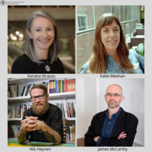
The AAG welcomes two new editors to take the positions of the Human Geography and Nature & Society editorships for the Annals of the American Association of Geographers. Kendra Strauss of Simon Fraser University will be taking over for Human Geography Editor Nik Heynen while Katie Meehan of King’s College London will assume the role of the Nature & Society Editor as James McCarthy’s term ends. The AAG sincerely thanks Nik Heynen and James McCarthy for their four years of exemplary service in these positions.
Kendra Strauss is both an Associate Professor and Director of the Labour Studies Program and The SFU Morgan Centre for Labour Research as well as an Associate Member of the Department of Geography at Simon Fraser University. Before taking on her current position, Strauss was an Urban Studies Postdoctoral Fellow at the University of Glasgow and then held a permanent lectureship in the Department of Geography at the University of Cambridge from 2012 to 2014. Her focus as a geographer and feminist political economist revolves around labor politics, the definition of work, the regulation of labor markets, and geographical imaginations of environmental change. Strauss brings to the Annals a background in editing as the co-editor of two books, Precarious Worlds: Contested Geographies of Social Reproduction and Temporary work, agencies, and unfree labour: Insecurity in the new world of work. She has also served on the editorial boards of six journals in geography, labor studies, and political economy.
A human-environment geographer and water policy specialist by training, Katie Meehan is Senior Lecturer in Human Geography at King’s College London and the lead PI of the Plumbing Poverty project. Prior to King’s, she was Assistant and then Associate Professor in the Department of Geography at the University of Oregon, from 2010 to 2019. Her expertise includes urban political ecology, infrastructure and social inequality, water insecurity and development, science and technology studies, climate change adaptation, and the politics of environmental knowledge at the science-policy interface. Meehan is a mixed methodologist, combining data from diverse sources such as ethnography, household surveys, Q method, and census data. Her research has appeared in journals such as Annals of the American Association of Geographers, Science, Geoforum, Environment and Planning D, Water International, Environmental Science and Policy, and WIREs Climate Change. Meehan is on the leadership team of the NSF-sponsored Household Water Insecurity Experiences Network.
The AAG would like to express its appreciation for the work of Nik Heynen as the past Human Geography Editor for the Annals. Heynen, a Professor in the Department of Geography at the University of Georgia, contributed his valuable experience as past Editor of Antipode and founding editor of the Geographies of Justice and Social Transformation Book Series to the AAG, ensuring the Annals remained a journal held in high regard by the Geography community.
A sincere thank you to James McCarthy as he leaves his post as the Nature & Society Editor for the Annals. A Professor of Geography at Clark University, McCarthy edited the most recent Special Issue of the Annals on Environmental Governance in a Populist/Authoritarian Era, which is now available as a stand-alone edited volume from Routledge. As the Nature & Society Editor since January 2016, McCarthy’s dedication has continued the tradition of publishing research of high quality and rigor expected from the AAG.
Strauss and Meehan will begin their service in these roles on January 1, 2020.
The American Association of Geographers congratulates the individuals and entities named to receive an AAG Award. The awardees represent outstanding contributions to and accomplishments in the geographic field. Formal recognition of the awardees will occur at the 2020 AAG Annual Meeting in Denver, CO during the AAG Awards Luncheon on Friday, April 10, 2020.
2020 Susan Hardwick Excellence in Mentoring Award
The AAG bestows an annual award recognizing an individual geographer, group, or department, who demonstrates extraordinary leadership in building supportive academic and professional environments and in guiding the academic or professional growth of their students and junior colleagues. The late Susan Hardwick was the inaugural Excellence in Mentoring awardee. The Award was renamed in her honor and memory, soon after her passing.
Jeffery Roth, Stephen F. Austin State University
The AAG Enhancing Diversity Committee, and the Committee on the Status of Women in Geography have selected Dr. Jeffery Roth of Stephen F. Austin State University to receive the 2020 AAG Susan Hardwick Excellence in Mentoring Award.
Dr. Roth’s nomination materials speak to his excellent mentoring abilities in advising students from a variety of backgrounds and his commitment to supporting students both professionally and personally. He truly embodies the exemplary legacy of the late Susan Hardwick. Dr. Roth has served as Geography Club advisor, he continues to create lifelong learners, has received teaching awards, and actively participates, and encourages students to participate in community activities. It is clear that Dr. Roth has shaped the lives of faculty, students, and members of the community in remarkable ways.
The AAG is proud and pleased to present the 2020 AAG Susan Hardwick Excellence in Mentoring Award to Dr. Jeffery Roth.
2020 Enhancing Diversity Award
The AAG Enhancing Diversity Award honors those geographers who have pioneered efforts toward, or actively participate in efforts towards encouraging a more diverse discipline.
Demetrice Jordan, Michigan State University
Demetrice (Dee) Jordan, has been a true change agent for diversity in our discipline.
Among Ms. Jordan’s many notable accomplishments, she founded and co-leads the Michigan State University Geography Department’s graduate student diversity recruitment initiative “Advancing Geography through Diversity,” which actively recruits and increases application submissions and acceptance among underrepresented minorities. Dee is a tireless mentor and advocate for creating an institutional climate that encourages the development of under-represented minorities as leaders in our discipline.
Ms. Jordan was named MSU’s 2018 Excellence in Diversity, Individual Emerging Progress recipient, as well as the 2018 Black Faculty, Staff and Administrators Association’s Graduate Student Emerging Leader recipient, becoming the first Geographer at MSU to hold these honors.
The AAG is proud and pleased to award Ms. Demetrice Jordan its 2020 AAG Enhancing Diversity Award.
2020 AAG Stanley Brunn Award for Creativity in Geography
The AAG Stanley Brunn Award for Creativity in Geography is given annually to an individual geographer or team of geographers that has demonstrated originality, creativity and significant intellectual breakthroughs in geography. The award includes a prize of $1,000.
Brian J. L. Berry, Lloyd Viel Berkner Regental Professor and Dean of the School of Economic, Political and Policy Sciences at The University of Texas at Dallas
Professor Berry is one of the most influential figures in the disciplines of geography, urban studies, and regional planning. Berry’s early urban and regional research helped spark the quantitative revolution that occurred in geography and urban research in the early 1960s, making him the world’s most frequently cited geographer for more than 25 years. Throughout Professor Berry’s distinguished career he has successfully bridged theory and practice and has been heavily involved in urban and regional planning in both developed and developing countries.
In addition, the AAG recognizes Dr. Berry’s service to the discipline, including as AAG President (1978-1979) and as dean of the former University of Texas at Dallas School of Social Sciences, transforming it during a period of rapid growth into the (now) School of Economic, Political and Policy Sciences. Professor Berry’s over 500 books and countless significant awards speak volumes on the impact of his research in geography, and its recognition in other scientific fields.
2020 AAG Honorary Geographer
The AAG annually selects an individual as the year’s Honorary Geographer. The award recognizes excellence in research, teaching, or writing on geographic topics by non-geographers. Past recipients include Stephen Jay Gould, Jeffrey Sachs, Paul Krugman, Barry Lopez, Saskia Sassen and Maya Lin.
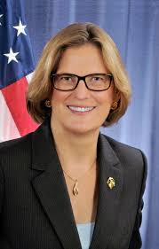
Kathryn Dwyer Sullivan, geologist, former NASA astronaut, NOAA Scientist, and 2017 Charles A. Lindbergh Chair of Aerospace History
The AAG Executive Committee recognizes Kathryn Sullivan’s distinguished career, including being the first American woman to walk in space, serving as Under Secretary of Commerce for Oceans and Atmosphere, and as a NOAA Administrator. The direction in which Sullivan steered Administration and NOAA priority work in the areas of weather and water services, climate science, integrated mapping services and Earth-observing capabilities is immediately recognized and welcomed by geographers. Sullivan also led NOAA with regard to satellites, space weather, water, and ocean observations and forecasts to best serve American communities and businesses. As a woman scientist and role model, Kathryn Sullivan mirrors many of the values the AAG also actively pursues in our discipline and our association.
2020 AAG Harold M. Rose Award for Anti-Racism Research and Practice
The Rose Award was created to honor Harold M. Rose, who was a pioneer in conducting research on the condition faced by African Americans. The award honors geographers who have a demonstrated record of this type of research and active contributions to society, and is awarded to individuals who have served to advance the discipline through their research, and who have also had an impact on anti-racist practice.
Dr. Audrey Kobayashi, Queen’s University
Dr. Kobayashi exemplifies the ideals of the AAG Harold Rose Award, with a decades-long commitment to anti-racist research that has reshaped the discipline with impact far beyond university walls. In terms of research, Kobayashi has published on anti-racist practice in top field journals and in her Presidential addresses to the AAG “The Idea of Race in Geography,” and to CAG “What’s Race Got to Do with it? The Geography of Racialization in Canada.”
Kobayashi’s writing is frequently taught in graduate courses, thus impacting the next generation of geographers in the project of building an anti-racist geography. She is an impressive model of anti-racist praxis, from her work advocating for employment equity in Canada to her involvement authoring commissioned reports on anti-racist practice, to her mentoring of early career underrepresented scholars and efforts to consult with university administrators. We will end with the words of one of the letters of support, “Rose’s effort to confront the “Geography of Despair” remains unfinished. However, as exemplified by the steadfast work of scholar-activists such as Professor Kobayashi, this work continues.
The 2020 Marble-Boyle Undergraduate Achievement Award in Geographic Science
The Marble-Boyle Undergraduate Achievement Award recognizes excellence in academic performance by undergraduate students from the U.S. and Canada who are putting forth a strong effort to bridge geographic science and computer science as well as to encourage other students to embark upon similar programs. The award is an activity of the Marble Fund for Geographic Science of the AAG.
Jacob Bostick, University of Colorado – Colorado Springs
Nathan Fiscus, University of North Alabama
Chelsie Perkins, East Tennessee State University
2020 Community College Travel Grants
Provides financial support for students from community colleges, junior colleges, city colleges, or two-year educational institutions to attend the Annual Meeting.
Martha (Kennedy) Masanzi, Santa Barbara City College
Ozer Ozturk, Lone Star College
Brenna Strawn, Lone Star College
Stuart Watts, Montgomery College
Every month the AAG compiles a list of newly-published books in geography and related areas. Some are selected for review in the AAG Review of Books.
Publishers are welcome to send new volumes to the Editor-in-Chief (Kent Mathewson, Editor-in-Chief, AAG Review of Books, Department of Geography and Anthropology, Louisiana State University, Baton Rouge, LA 70803).
Anyone interested in reviewing these or other titles should also contact the Editor-in-Chief.
PLEASE NOTE: Due to current public health policies which have prompted the closing of most offices, we are unable to access incoming books at this time. We are working on a solution during this transition and will continue our new books processing as soon as we can. In the meantime, please feel free to peruse previous books from our archived lists.
After Geoengineering: Climate Tragedy, Repair, and Restoration by Holly Jean Buck (Verso Books 2019)
Blue Legalities: The Life and Laws of the Sea by Irus Braverman and Elizabeth R. Johnson, eds (Duke University Press 2020)
City of Refuge: Slavery and Petit Marronage in the Great Dismal Swamp, 1763-1856 by Marcus P. Nevius (University of Georgia Press 2020)
Disaster Upon Disaster: Exploring the Gap Between Knowledge, Policy and Practice by Susanna M. Hoffman (Bergahn Books 2019)
Half Broke: A Memoir by Ginger Gaffney (W. W. Norton & Company 2020)
The Licit Life of Capitalism: US Oil in Equatorial Guinea by Hannah Appel (Duke University Press 2019)
Making Industrial Pittsburgh Modern: Environment, Landscape, Transportation, Energy, and Planning by Jill Lindsey Harrison (MIT Press 2019)
Murals of the Americas: Mayer Center Symposium XVII, Readings in Latin American Studies by Victoria I. Lyall, ed (University of Oklahoma Press 2019)
Punctuations: How the Arts Think the Political by Michael J. Shapiro (Duke University Press 2019)
Education: M.A. in Geography (George Washington University), B.A. in Environmental Studies (Eckerd College)
Describe your job. What are some of the most important tasks or duties for which you are responsible?
In our workplace, we use a variety of decision support services and I am responsible for knowing how to use all of them, providing geospatial training, and responding to certain map requests. We use a variety of vector, raster, and satellite imagery data sets, requiring advanced knowledge to ensure proper scientific data handling to efficiently conduct analysis. My work involves mapping crop conditions, weather, crop distribution, and trade policy and effects. Sometimes, I have a project for 2-3 weeks and other times, I have new challenges each day. Each map request requires me to be creative in distilling multiple data sets into clear and concise policy messages. We talk a lot about the subtle messages conveyed in our use of colors, annotations, and other cartographic features.
What attracted you to this career path?
I was attracted to this industry because geography provides a more flexible approach to integrating different disciplines of information into summary messages about health, the environment, international development, and other complex topics. Working in agriculture, especially around the world, addresses many of the interdisciplinary topics that interest me, including food security, sustainable development, and poverty alleviation.
How has your education/background in geography prepared you for this position?
As an analyst, I was required to take initiative to learn how to process satellite imagery into clear, concise stories about current crop conditions. I had to be flexible in identifying areas where the data and tools I had could provide a reliable and accurate sense of the crop conditions, taking into consideration constraints in the spatial resolution, timing, cloud free percentage, and other details that would hinder or support my ability to perform the analysis. Time and computer network constraints often played a significant role in figuring out if an analysis would be realistic to tackle.
My education in geography and specifically remote sensing provided me with the necessary foundation to advance my skills for the specific analytical demands of my current workplace. In addition, my background in policy communication greatly supported me in creating well-received map products that simplified complex data into clear policy messages. I really loved doing that analytical work.
More recently, I have become a graphics editor and training coordinator to help build upon the geospatial skills of my colleagues. With newer staff and the many decision support tools that we use, it is challenging to stay abreast of application developments. Communicating how I did my work, while staying abreast of the applications, is a newer and still rewarding challenge for me. I enjoy sharing my love of geospatial analysis and remote sensing with colleagues, especially as the industry leap frogs forward with technological advancements.
What geographic skills and information do you use most often in your work? What general skills and information do you use most often?
Geographic skills: I think I most often use location identification, in the sense of advising colleagues to clarify the locational extent of the map image. This is done by adding rivers, roads, cities, and other geographical context to the maps of satellite imagery and other raster data sets. Yet there is more to this. The main geographic questions we tackle are (1) how much grows (in terms of crops) in a given place and (2) what are the conditions of the crops in that place? The important skills myself and colleagues use to answer these questions are spatial joins (aka, making geospatial data sets from tabular data), difference mapping (with raster calculator and post-classification change detection), zonal statistics (to help summarize data to counties or states), and other area calculations.
In the world of remote sensing, I am also required to know the name of many satellite sensors and some basic sensor specifications. For example, sometimes management thinks higher spatial resolution would help make it easier to answer key questions, but these sensors are often missing other critical data. I periodically engage in important discussions about the trade-offs between time and processing speed when considering the geographic extent, timing, and spatial resolution of different imagery sources. Having the technical expertise and yet flexibility to talk with non-technical decision makers is a critical aspect of my work.
General skills: I frequently use writing and presentation skills. I present at conferences about interesting analysis I have done or new product development, such as the Global Agricultural & Disaster Assessment System (GADAS). GADAS is a free, global website that provides a geospatial platform for analysis with hundreds of data layers. When showcasing this or other workflows, I heavily utilize my PowerPoint skills preparing slides. My work also requires me to talk with users of our applications to figure out their challenges and the assumptions that they bring to the application. Sometimes knowing an application well makes a person blind to how others might approach using the same tool. I frequently communicate with people who are not trained in geography, but it is my responsibility to help them be able to perform certain geographical tasks. It can be challenging and requires me to have patience and sometimes think creatively.
Honestly, I far more frequently use general skills to perform my duties, as I review our decision support systems, report bugs on where the applications are having issues, and advise on improvements to these systems. Technically, I am testing geospatial applications and therefore using geospatial skills, but any tester can tell you that they are not being overly creative in performing this task. My work involves far more documentation than I would probably prefer to admit. Yet, concise writing that captures a concern or requirement for a developer to efficiently fix or enhance a decision support tool has its merits. That “telephone game” sometimes works better than other times. When it works, it is very rewarding.
Are there any skills or information you need for your work that you did not obtain through your academic training? If so, how/where did you obtain them?
Sure, and yet the skills I need I have built upon from my academic training. For example, my previous career in the non-profit world taught me more about using PowerPoint effectively and giving presentations, and yet I learned presentation skills during school as well. In addition, I of course had to write many papers in college and graduate school. These assignments prepared me well, and yet I spent my first 3-5 years in DC learning a completely different writing style. After all, policy memos, briefing papers, and even 5-15 minute presentations for the office are so different from what I did in college.
Here’s another way of thinking about this: some people believe the purpose of going to college is to learn a skill, but instead it is often to learn how to think critically. So how do I identify skills I learned outside of school, when I am constantly thinking through new challenges and exploring solutions to build upon my academic foundation? To me, this is honestly the difference between a job and a career; and I love having a career.
Do you participate in hiring, screening, or training of new employees? If so, what qualities and/or skills do you look for?
First and foremost, I look for the skills needed to perform the job. This is sometimes easier said than done. I work in a place that needs talented people in a variety of arenas. Finding a person with a diverse set of skills can be very challenging and this makes the art of screening for new employees more fluid than some people might expect.
We need people who can be clear and concise in presenting information. The resume or CV is a first indication of this skillset. Sometimes technical people list out all of their skills, but with little organizational structure that helps provide a sense of the person and their history. I always look for people with not only the technical skills, but also an interest area relevant to our work, whether this is meteorology, agronomy, international development, food security, or another relevant field. This helps me know the person could provide scientific quality analysis in an operational environment.
We also look for a person who can be flexible to work with a variety of personality types. Every workplace has a culture and it’s nice to find people who can blend into that culture instead of shaking it up. An interview is as much about the candidate as it is about the team and being able to envision the candidate contributing something new or missing to the team.
What advice would you give to someone interested in a job like yours?
First, don’t be afraid to get to know a variety of tools. Second, geography is a tool that can be applied in many different disciplines. Take the time to develop some expertise in a discipline, where you can geospatially analyze relevant data. Conducting analysis goes beyond knowing how to use the tools, as it is important to also understand the data and proper data handling needs. Third, realize all jobs involve some data cleaning, file management, and time management. No one is too important to do these tasks.
Most importantly, my advice is to take on challenges. Start by finding the little things that are not working well and fixing them. Focusing on tasks within your areas of responsibility that help things function better is a way for you to take initiative and expand your area of expertise. Finding the right time and place to take initiative is incredibly important. It makes all the difference between getting criticized for stepping outside your lane and being rewarded for showing the necessary initiative to solve an important problem. Workplaces are as broken as we allow them to be, so try not to be the source of problems when there is so much interesting work that could be done.
What is the occupational outlook for career opportunities in your field/organization, esp. for geographers?
Sometimes I think geography is currently exploding. Technological infrastructure has finally caught up with the wishes and desires of many analysts. Now with cloud computing, it could be possible to process not just gigabytes, but terabytes of data. Demand for geographers, especially combined with remote sensing data, has increased over the past 10 years, and with more powerful computers the possibilities for working with these data are only limited by our creativity.
Doug M. Amedeo, professor emeritus of geography at the School of Natural Resources, died Dec. 4, 2019, in Lincoln.
Amedeo was a leader in environmental perception and behavioral geography, focusing his career on the human dimensions of environmental and spatial issues. He began as an associate professor at the University of Nebraska-Lincoln in 1973, after serving for five years as an assistant professor at the University of California.
By 1992, he was promoted to full professor, and in 1993, he became the chair of the Department of Geography, which later was merged with the Department of Anthropology, and then the School of Natural Resources, his permanent faculty home. He served in that role for three years.
Amedeo also was a permanent member of editorial boards for the journals of “Architectural and Planning Research” and “Environment and Behavior,” and served on more than 18 university committees over the years.
During the course of his career, he published and presented more than 70 books, chapters, articles or papers and advised nearly 20 graduate students in pursuit of their doctorate degree. Even in his retirement, he continued to work with, advice and inspire students at the University of Nebraska-Lincoln.
Amedeo was born Sept. 21, 1932, in Brooklyn, New York, to Guido and Jean (Gong) Amedeo. He served in the Korean War and, in 1962, earned his bachelor’s degree in economics from Wisconsin State University. He earned his master’s and doctorate degrees in geography from the University of Iowa in 1965 and 1967, respectively.
In 1977, he married Patricia Herriott, who survives him. He also is survived by his daughters, Cynthia Amedeo Nelson of Lincoln and Elizabeth Amedeo Stigleman (Marty) of Midland, Michigan.
A celebration of his life will be in spring 2020; Wyuka Funeral Home is in charge of arrangements. In lieu of flowers, memorials made be made to women’s, children’s or animal charities. Condolence can be left at Wyuka.com.
Published from the School of Natural Resources, University of Nebraska – Lincoln.
The AAG is proud to announce the Fall 2019 student winners of the AAG Council Award for Outstanding Graduate Student Paper at a Regional Meeting. The AAG Council Award for Outstanding Graduate Student Paper at a Regional Meeting is designed to encourage graduate student participation at AAG Regional Division conferences and support their attendance at AAG Annual Meetings. One graduate student in each AAG Regional Division receives this yearly award based on a paper submitted to their respective regional conference. The awardees receive $1,000 in funding for use towards their registration and travel costs to attend the AAG Annual Meeting. The board members from each region determine student award winners.
The winners from each region will be presenting their papers in two dedicated paper sessions at the upcoming 2020 AAG Annual Meeting in Denver, CO.
MSDAAG: Matthew Walter, Masters Student, University of Delaware; Paper title – A Rapidly Assessed Wetland Stress Index (RAWSI) Using Landsat 8 and Sentinel-1 Radar Data
GPRM: Cheyenne Sun Eagle, Masters Student, University of Kansas; Paper title – Spatial and Temporal Patterns of Land Allotment on the Pawnee Reservation
SWAAG: Katherina Kang, Masters Student, University of North Texas in the Department of Geography; Paper title – Vegetation and land use effects on the spatial distribution and accumulation of soil black carbon in an urban ecosystem
WLDAAG: Junghwan Kim, Ph.D. Student, University of Illinois at Urbana-Champaign; Paper title – How Neighborhood Effect Averaging May Affect Assessment of Individual Exposures to Air Pollution: A Study of Individual Ozone Exposures in Los Angeles
ELDAAG: Rebekka Apardian, Ph.D. Student of Spatially Integrated Social Sciences, University of Toledo; Paper title – Exploring the Relationship Between Pedestrian Crashes and Walkability
NESTVAL: Michaela Garland, Master’s Student, Southern Connecticut State University; Paper title – Evaluating, initiating, and incubating Blue Economy development – Case of the Long Island sound region
APCG: Dustin Tsai, PhD candidate, University of California Davis; Paper title – A Tale of Two Croatias: How Club Football (Soccer) Teams Produce Regional Divides in Croatia’s National Identity
SEDAAG: Jordan Brasher, PhD candidate, University of Tennessee-Knoxville; Paper title – “Contesting the Confederacy: Mobile Memory and the Making of Black Geographies in Brazil”
MAD: Kelly J. Anderson, University of Maryland College Park, Middle Atlantic Division; Paper title – “Weather-related Influences on Rural-to-urban Migration: A Spectrum of Attribution in Beira, Mozambique”