Geographers Recognized for National Research on COVID-19
Projects address mobility patterns, access to health care and food systems, racial and disability disparities during the pandemic
WASHINGTON, DC…Geographers have been recognized in 16 research and educational fellowships from The Geospatial Software Institute (GSI) Conceptualization Project. The fellowships support 14 projects that tackle COVID-19’s challenges for public health, social networks and contact tracing, housing stability, and disparities due to age, race, and disabilities, using geospatial software and advanced capabilities in cyberinfrastructure and data science. A full list of the fellows, with biographies and project information, is at https://gsi.cigi.illinois.edu/geospatial-fellows-members/.
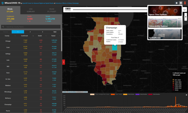
“The COVID-19 crisis has shown how critical it is to have cutting-edge geospatial software and cyberinfrastructure to tackle the pandemic’s many challenges,” said Shaowen Wang, a geographer who is the principal investigator of the NSF project and founding director of the CyberGIS Center at University of Illinois Urbana-Champaign. “We are extremely grateful for NSF’s support to fund this talented group of researchers, whose work is so diverse yet complementary.”
The American Association of Geographers (AAG) is a partner in the GSI Conceptualization Project, which is supported by the National Science Foundation (NSF). Other partners include the Consortium of Universities for the Advancement of Hydrologic Science, Inc. (CUAHSI), the National Opinion Research Center (NORC) at the University of Chicago, Open Geospatial Consortium (OGC), and University Consortium for Geographic Information Science (UCGIS). Technical and cyberinfrastructure support are provided by the CyberGIS Center for Advanced Digital and Spatial Studies (CyberGIS Center) at the University of Illinois at Urbana-Champaign.
“Geospatial technologies connect us and make us more geospatially aware, and in doing so, diminish everyday inconveniences,” said Coline Dony, senior geography researcher at AAG. “The AAG is committed to working with groups like GSI to ensure that the complex, interrelated, social, environmental, and scientific challenges of geospatial technologies are addressed. I think these challenges are what the GSI and Geospatial Fellows are well-positioned to accomplish.”
The Fellows come from varied professional, cultural, and institutional backgrounds, representing many disciplinary areas, including public health, food justice, hazard prediction and response, housing and neighborhood change, and community-based mapping. The fellowship projects represent frontiers of emerging geospatial data science, including for example deep learning, geovisualization, advanced approaches to gathering and analyzing geospatial data, and GeoAI.
Pioneered by multi-million research funded by NSF, cyberGIS (i.e., cyber geographic information science and systems based on advanced computing and cyberinfrastructure) has emerged as a new generation of GIS, comprising a seamless integration of advanced cyberinfrastructure, GIS, and spatial analysis and modeling capabilities while leading to widespread research advances and broad societal impacts. Built on the progress made by cyberGIS-related communities, the GSI conceptualization project is charged with developing a strategic plan for a long-term hub of excellence in geospatial software infrastructure, one that can better address emergent issues of food systems, ecology, emergency management, environmental research and stewardship, national security, public health, and more.
The Geospatial Fellows program will enable diverse researchers and educators to harness geospatial software and data at scale, in reproducible and transparent ways; and will contribute to the nation’s workforce capability and capacity to utilize geospatial big data and software for knowledge discovery.
With a particular focus on COVID-19, the combined research findings of the Fellows will offer insight on how to make geospatial research computationally reproducible and transparent, while also developing novel methods, including analysis, simulation, and modeling, to study the spread and impacts of the virus. The Fellows’ research will substantially add to public understanding of the societal impacts of COVID-19 on different communities, assessing the social and spatial disparities of COVID-19 among vulnerable populations.
For more information about the GSI conceptualization project, see their website: https://gsi.cigi.illinois.edu/.
For a list of Geospatial Fellows and their projects, visit https://gsi.cigi.illinois.edu/geospatial-fellows-members/
For more than 100 years The American Association of Geographers (AAG) has contributed to the advancement of geography. Our members from nearly 100 countries share interests in the theory, methods, and practice of geography, which they cultivate through the AAG’s Annual Meeting, scholarly journals (Annals of the American Association of Geographers, The Professional Geographer, the AAG Review of Books and GeoHumanities), and the online AAG Newsletter. The AAG is a 501(c)3 nonprofit organization founded in 1904.
FOR INTERVIEWS OR INFORMATION, CONTACT Lisa Schamess, phone 202.234.1450, ext 1164 or lschamess [at] aag [dot] org
 The GIS Certification Institute or GISCI was established in 2002 by member organizations: Association of American Geographers (AAG), Geospatial Information and Technology Association (GITA), National States Geographic Information Council (NSGIC), University Consortium of Geographic Information Science (UCGIS), Urban and Regional Information Systems Association (URISA), to provide the GIS community with a complete certification program, leading to Certified GIS Professionals.
 Clancy Wilmott is at the University of California at Berkeley where she serves as an Assistant Professor in Critical Cartography, Geovisualisation and Design in the Berkeley Centre for New Media and the Department of Geography. Wilmott received her PhD in Human Geography from the University of Manchester and also holds undergraduate degrees in Communications (Media Arts and Production) and International Studies (Italian), as well as a postgraduate degree in Cultural Studies from the University of Technology, Sydney.
 We would like to express their heartfelt thanks to John Kelmelis for his service and dedication in the last 5 years. He has contributed tremendously the advancement of the GISP credential through providing guidance on important policy issue surrounding the implementation and subsequent revisions to the GISCI Geospatial Core Technical Knowledge Exam that has become a foundation of the GISP certification. John also served on the Executive Director search committee that began its work following Bill Hodge’s announcement of his upcoming retirement.
 The UK Academy of Social Sciences announced today that it has conferred the award of Fellow on US geographer Mei-Po Kwan, among other leading social scientists.
 Three long-time AAG members met up recently at the 4th International Geography Youth Summit (IGYS) in Bengaluru (formerly Bangalore), India. The IGYS was developed as part of The Institute of Geographical Studies (TIGS) in Bengaluru. Both are the brainchilds of AAG member, Dr. Chandra Shekhar Balachandran, who founded TIGS in 2000. Together with collaborators and partners in India and the US, TIGS organizes year-round workshops with teachers, parents and students in Indian urban and rural schools to introduce geography as culturally relevant and meaningful. This kind of geography challenges traditional textbook approaches and extends learning beyond the classroom.
 This year, Dr. Sue Roberts from the University of Kentucky attended IGYS for the first time and gave the Keynote address. She says, “What impressed me most was the way the students took geographical concepts and ran with them. They generated truly fresh ways of approaching complex problems that we adults and professionals can sometimes make rather boring” and she added “the students had no problem connecting their research findings to practical action.”
 Additionally, the AAG has kicked off a brand new resource to highlight geographers interested in and available to give presentations on various aspects of geographic thought and research. The
  Geographer and artist
  The United States Geospatial Intelligence Foundation (USGIF) has appointed Camelia Kantor as its new Director of Academic Program. In this position, she will manage USGIF’s Collegiate GEOINT Accreditation Program, which awards students GEOINT Certificates accompanying their college degrees. Kantor was formerly an associate professor of geography at Claflin University in South Carolina. Most recently, she has served as a GeoMentor. Kantor is the recipient of AAG’s 2017 Dr. Helen Ruth Aspaas SAGE Innovator Award. The award is named for one of the founding members of the SAGE (Stand-Alone Geographers) Specialty Group, Dr. Helen Ruth Aspaas, a retired professor from Virginia Commonwealth University, and recognizes an outstanding and innovative Stand Alone Geographic Educator. To learn more, visit
  , president-elect at Ohio University (OU), will join Dr. Mary Ellen Mazey of Bowling Green State University (BGSU) as a leader of a public academic institution in Ohio. Mazey began her Presidency at BGSU in July of 2011 and holds a PhD in Geography from the University of Cincinnati, while Nellis holds his PhD in Geography from Oregon State University.