2016 AAG Honors Announced

The AAG is pleased to announce the selection of eight Honorees who will receive the 2016 AAG Honors in one of six categories. Recipients to be honored at an annual awards luncheon during the AAG Annual Meeting are:

  • Susan Christopherson, Cornell University, Lifetime Achievement Award
  • George Malanson, University of Iowa, Lifetime Achievement Award
  • Aaron Wolf, Oregon State University, Gilbert White Public Service Award
  • Linda Mearns, National Center for Atmospheric Research, AAG Distinguished Scholarship Award
  • Ibipo Johnston-Anumonwo, State University of New York, College at Cortland, Distinguished Teaching Award
  • Kavita Pandit, University of Georgia, Ronald F. Abler Distinguished Service Honors
  • Carrie Stokes, United States Agency for International Development, Gilbert White Public Service Award
  • William R. Strong, Emeritus Professor, University of North Alabama, Gilbert Grosvenor Geographic Education Honors

AAG Honors are the highest awards offered by the Association of American Geographers.  They are offered annually to recognize outstanding accomplishments by members in research & scholarship, teaching, education, service to the discipline, public service outside academe and for lifetime achievement.  Although the AAG and its specialty groups make other important awards (see Grants and Awards), AAG Honors remains among the most prestigious awards in American geography and have been awarded since 1951 (complete list).

Nominations are invited from individual AAG members, specialty groups, affinity groups, departments, and other interested parties.  Currently, honors are awarded in several categories, including Distinguished Teaching Honors, Gilbert F. White Distinguished Public Service Honors, Ronald F. Abler Distinguished Service Honors, Gilbert Grosvenor Honors for Geographic Education, Distinguished Scholarship Honors, and Lifetime Achievement Honors.

All AAG awards will be presented at the upcoming AAG Annual Meeting in San Francisco, Calif., during a special awards luncheon on Saturday, April 2, 2016.

About the Honorees

(select a name to view citations)

Susan Christopherson is recipient of the Lifetime Achievement Award for her considerable and long standing contributions to research, public engagement, teaching, and service. Her work on media, optics, agriculture, renewable energy, and manufacturing has included engagement with local economic development authorities to produce research that contributes to spatially and socially balanced economic growth. Christopherson’s more recent work on nontraditional energy sources has continued this tradition, including her appointment to a National Research Council panel to consider the implications of shale gas and oil development for local communities and the dissemination of policy reports on the risks and impacts of crude oil rail transport. As the first woman to be promoted to full professor within her department as well as the first female chair, she has also broken ground in terms of increasing diversity within the field of economic geography, which she has also done through her mentoring and teaching.

George Malanson’s work tackles one of the most challenging and highly charged issues of our time – climate change. His work is exceptional in its recognition of the complexity of the factors impacting our rapidly changing environment — its response to natural disturbance and human impact. Indeed, he is regarded as one of the world’s leading scientists on the topic and has come to be recognized for his path breaking and thoughtful research, insights informed by science, creativity, scholarly productivity, and service. He is also widely respected as a mentor and instructor. Included among his many accomplishments is his 1993 book, ‘Riparian Landscapes’ (1993). It is regarded by many as seminal in landscape-ecological research. His work and contributions are praiseworthy and indeed he is highly deserving of the AAG Lifetime Achievement Award.

Aaron Wolf has been selected as one of two recipients of the award given in Gilbert White’s honor. Throughout the world and in multiple contexts (both academic, governmental, and policy), Wolf is known for bringing a humanitarian, benevolent approach to his work on transboundary water resources. He combines environmental science with strategies from conflict/dispute resolution and spiritual teaching from a variety of faiths. He has also established himself as a ‘meticulous scholar’ driven by a ‘sense of duty’. He was recently recognized for his work to motivate a generation of once doubting decision makers entrenched in Middle East water politics. He is indeed a giant in the field.

This year’s 2016 Distinguished Scholarship Award is going to Linda Mearns for her pioneering and agenda setting contributions to the field of climate change assessment science, particularly her sustained efforts to understand how climate change will be translated into climate variability and extremes and to model climate change at the regional level. She has made unparalleled contributions to international and national climate change assessment efforts, including authorship on four assessment reports issued by the Intergovernmental Panel on Climate Change; and has led numerous climate assessment projects, including directorship of the North American Regional Climate Change Assessment Program. Linda’s sustained and impressive record of scholarship makes her highly deserving of this award.

Ibipo Johnston-Anumonwo is recipient of the Distinguished Teaching Award for her exemplary contributions to geographic education both within and outside the classroom. She has been a faculty member at SUNY College at Cortland for over 25 years. She is an exceptional teacher-scholar with a strong national and international reputation in the discipline of geography. Johnston-Anumonwo is highly active in geographic education through various organizations such as the National Council on Geographic Education, the New York African Studies Association, and the AP Human Geography Program. In addition, she has published in numerous textbooks on Africa, urbanization, and feminist geography. Finally, her outstanding career in teaching is evident in her dedication to student success.

Kavita Pandit is awarded Ronald F. Abler Distinguished Service Honors in recognition of the broad impact of her extraordinary service to geography. Pandit’s many contributions include serving as AAG President and regional councilor of the Southeastern Division of the organization; leadership roles in the Population Specialty Group of AAG; and distinguished appointments and leadership positions in international education. She has also held several prominent editorial board memberships and contributed to numerous national and international institutions including the American Geographical Society and the Association of International Educators. Pandit is a steadfast supporter of AAG. She respects the diverse nature of geography in its subfields, its differing institutions, its role in K-12 education, and its application outside of academia. She is truly deserving of this honor.

Carrie Stokes has been selected as one of two recipients of this year’s Gilbert White Public Service Award. Stokes epitomizes the ‘geographer as leader’ as demonstrated by her unwavering commitment to public service through advancing geography within and beyond government, Through her years of advocacy, leadership and action to promote the use of remote sensing and GIS to inform international development, humanitarian assistance, and climate change mitigation, she has had a profound impact on government policy and its on-the-ground effectiveness around the world, from Bangladesh to Central America. As an unsurpassed ambassador for geography and its ability to transform development programming, she deserves our highest commendation as an “enabler of dreams.”

Through his foundational work with the Alabama Geographic Alliance and the National Geographic Society’s education program, William Strong has worked, and continues to work, with educators and geographers to improve the teaching of geography at the primary and secondary school levels. As a faculty member and long-term chair of the Department of Geography at the University of North Alabama, Strong is also an outstanding geographic educator in his own right while diligently advocating for geography in higher education. Between his work in geographic education and his work as a geographic educator, Strong has had a significant impact on the landscape of geographic education in the United States. He is being recognized here for his extensive and selfless contributions to geographic education.

    Share

Geography Is Still an Important Part of K-12 Education Bill

As you are likely aware, Congress has been working throughout 2015 to reauthorize the Elementary and Secondary Education Act (ESEA; currently known as No Child Left Behind) – the primary federal law dealing with K-12 education policy. We have been monitoring the process throughout the year and have engaged with Congressional leaders to stress the importance of federal funding opportunities for K-12 geography. We have also written to you multiple times to share key updates.

In recent months, the House and Senate each approved separate versions of ESEA reauthorization legislation, and two weeks ago, senior members from the two houses met to reconcile differences between the bills. The resulting “conference report” was released this week. Here’s our initial analysis:

The Every Student Succeeds Act (ESSA) is the name given to the House/Senate conference report for the current reauthorization of the Elementary and Secondary Education Act.  The conference report will be voted upon by the House this week (possibly as soon as late this afternoon) and the Senate next week.  If both houses approve it, the bill will go to President Obama for signature or veto.

Overall, we view the conference report as a positive for geography.  While there is no stand-alone grant program for our discipline, there are several grant programs (detailed below) that specifically mention geography as an eligible subject for grant proposals.  Given the all-encompassing focus by Congressional Republicans on returning control to the states and localities, we frankly think this is about the best we could have hoped for.

Additionally, geography is specifically included as both a core academic subject and as part of “well-rounded education” as defined in the law.

Here are the specific mentions of geography in the bill:

Page 391 – Part of Title II of the legislation – this is a history/civics/geography grant program that we had been aware of and have written to you about previously.  It’s no longer broken down into three sections as it had been in the Senate bill, and it’s now authorized as part of a larger series of grant programs that includes teacher incentive grants and literacy education funding.

Nonprofit entities and higher-ed institutions are eligible grant recipients under the program and there’s a specified requirement to focus on underserved student populations in grant activities.  We are pleased with the way this section is written as compared to how it had appeared in the Senate bill.

Page 460 – Part of Title IV of the legislation – this specifies that states may use certain funds to support local education agencies (LEAs) in “well-rounded education” activities, which includes geography.

Page 477 – Part of Title IV of the legislation – this section spells out various requirements for grants to LEAs and requires some funds to be used for “well-rounded educational opportunities.”  Geography is one of the subjects specified as being part of a well-rounded education for purposes of these expenditures.  The bill also says that LEAs can conduct these activities in partnership with a nonprofit entity or higher-ed institution.

Page 579 – Part of Title IV of the legislation – this section deals with grants to magnet schools and specifies that expenditures must be related to a series of activities, including “improving student knowledge of” various subjects, one of which is geography.

Page 683 – Part of Title VI of the legislation – this deals with grants to aid in the “educational needs of educationally-disadvantaged” Native American students and is focused on raising achievement in various subjects, one of which is geography.

Page 807 – In this section, a “well-rounded education” is defined and includes instruction in a number of subjects, one of which is geography.  We don’t recall previous versions of the ESEA having specified a definition of this term – and it’s good that geography is included.

Page 1019 – This section defines the “core academic subjects” for the ESEA and geography is again included.

Looking forward, we might focus on:  1) Working directly with states and localities to encourage them to use their flexibility to apply funds to geography-related activities; and 2) Continue to make the case that geography is a STEM discipline critical to job growth and that there needs to be a dedicated federal grant program to improve the teaching of our discipline.  We think the recent GAO report and the AAG Resolution on Geography Education can help in conveying this message.

As always, please do not hesitate to contact us if you have any questions or concerns. John Wertman, the AAG’s Senior Program Manager for Government Relations, can be reached at jwertman [at] aag [dot] org, and Doug Richardson, AAG Executive Director, at drichardson [at] aag [dot] org. And our very best for the holiday season!

Sincerely,

Douglas Richardson and John Wertman

    Share

American Scholarly Societies Joint Statement on ‘Campus Carry’ Legislation

The Association of American Geographers joins our colleagues in 28 other scholarly societies in opposing policies designed to facilitate the carrying of guns on college campuses. We encourage any state considering such policies to bring the perspective of geographers and other educators throughout the United States to the debate. Following is the official joint statement:

The undersigned learned societies are deeply concerned about the impact of Texas’s new Campus Carry law on freedom of expression in Texas universities. The law, which was passed earlier this year and takes effect in 2016, allows licensed handgun carriers to bring concealed handguns into buildings on Texas campuses. Our societies are concerned that the Campus Carry law and similar laws in other states introduce serious safety threats on college campuses with a resulting harmful effect on students and professors.

American Academy of Religion
American Anthropological Association
American Antiquarian Society
American Association for the History of Medicine
American Folklore Society
American Historical Association
American Musicological Society
American Philosophical Association
American Political Science Association
American Studies Association
American Society for Aesthetics
American Society for Environmental History
American Sociological Association
Association for Slavic, East European, and Eurasian Studies
Association of American Geographers
College Art Association
Latin American Studies Association
Law and Society Association
Medieval Academy of America
Middle East Studies Association
Modern Language Association
National Communication Association
National Council on Public History
Oral History Association
Society for American Music
Society of Architectural Historians
Society of Biblical Literature
Society for Ethnomusicology
World History Association

    Share

Addressing Challenges For Geospatial Data-Intensive Research Communities: Research on Unique Confidentiality Risks and Geospatial Data Sharing within a Virtual Data Enclave

Photo illustration showing hands pointing to various forms of data

Geospatial Data Confidentiality

The AAG teamed up with the Inter-university Consortium for Political and Social Research at the University of Michigan to lead an NSF-funded program of research to address the challenges facing geospatial data-intensive research communities.

Research combining a variety of intensive geographically-referenced data streams is spreading across many scientific domains, ranging from environmental science to transportation to epidemiology, and opportunities to create new multi-disciplinary and data-intensive scientific collaborations are expanding.

Yet, the unique characteristics of geo-referenced data present special challenges to such collaborations. These data are highly identifiable when presented in maps and other visualizations. The potential opportunities and benefits of collaboration are constrained by the need to protect the locational privacy and confidentiality of subjects in research using geo-referenced data.

The project is entitled Addressing Challenges For Geospatial Data-Intensive Research Communities: Research on Unique Confidentiality Risks and Geospatial Data Sharing within a Virtual Data Enclave.

The focus is on the unique confidentiality characteristics of geospatial data and their visualizations, on disclosure risks, and on the potential for sharing geospatial data within a Virtual Data Enclave (VDE).

The aim is to engage the geospatial research community in an effort to:

  • conduct research on the unique confidential characteristics of large geo-referenced data sets and on viable ways to manipulate these data and their geo-visualizations to protect confidentiality and privacy;
  • conduct research on methods and procedures to assess and reduce disclosure risks in maps and other research projects derived from locationally identifiable data;
  • conduct research regarding the viability of sharing and archiving confidential geo-referenced research data using a VDE to enable sophisticated analyses of these data under conditions that protect the privacy of research subjects; and
  • test confidentiality methods within the geospatial VDE to reduce disclosure risk and develop standards for disclosure review.
    Share

New Books: November 2015

Every month the AAG compiles a list of newly-published books in geography and related areas. Some are selected for review in the AAG Review of Books.

Publishers are welcome to send new volumes to the Editor-in-Chief (Kent Mathewson, Editor-in-Chief, AAG Review of BooksDepartment of Geography and Anthropology, Louisiana State University, Baton Rouge, LA 70803).

Anyone interested in reviewing these or other titles should also contact the Editor-in-Chief.

November, 2015 

    Share

Beth Schlemper Attends White House Summit on Next Generation Schools to Highlight STEM Education

Dr. Beth Schlemper, associate professor in the University of Toledo Department of Geography and Planning, was among the students, educators, philanthropists, and entrepreneurs invited to Washington for the first-ever event to share their efforts to reinvent the high school experience to better empower students to seize opportunities in today’s economy, and prepare students for success in college and career. She attended November 10th’s White House Summit on Next Generation Schools to highlight her STEM education project.

The UT project aims to develop a curricular model that provides an accessible way of introducing geospatial thinking to students while providing them with the skills and motivation to pursue STEM careers.

Schlemper is engaging underrepresented students in real-world issues in the context of their own neighborhoods through the use of geospatial technologies and skills. Students are gaining knowledge and tools for enhancing their communities, as well as exposure to career opportunities in high-growth STEM sectors.

The White House Summit is part of the President’s 2015 State of the Union push for a national effort to create more Next Generation High Schools — schools that incorporate key elements of redesign, including more personalized and active learning, access to real-world and hands-on learning such as “making” experiences, deeper ties to post- secondary institutions, and a focus on expanding STEM opportunities for girls and other groups of students who are underrepresented in these high-growth, well-paying fields.

Click here for additional information on the White House Summit on Next Generation High Schools.

    Share

International AAG Members Contribute to Timely Book

Four AAG members Tiit Tammaru, University of Tartu; Szymon Marcińczak, University of Łódź; Maarten van Ham, Delft University of Technology & University of St. Andrews; and Sako Musterd, University of Amsterdam, make up an international team of researchers which has edited a new book, Socio-Economic Segregation in European Capital Cities. East meets WestThe book offers an account of the spatial dimension of rising inequalities in Europe. Since it’s release in late August, the volume has been noted in more than 50 articles, presentations and interviews, including in The Guardian and El Pais.

    Share

San Francisco, on the Golden Edge

The AAG returns to San Francisco for its annual gathering in 2016, our fourth visit following successful meetings there in 1970, 1994, and 2007. Given the unique strengths of geospatial science for the synthesis of human, physical, economic, historical, demographic, and other elements into a composite picture, the San Francisco Bay Area is a rich setting for our meeting. A “golden edge,” that sits in a cradle of faults aligned along the margins of two of Earth’s vast plates—the North American and Pacific. Evolving through a colorful history plated with wealth from a sequence of economic booms, beginning with gold and silver, then railroads, land development, oil, and war industries, on into aerospace, and the computer era. San Francisco is a place on the edge in many ways, setting styles, tones, and motifs that season our life and times.

Figure 1: San Francisco, California, looking north across the city to the Marin headlands. (Photo by Bobbé Christopherson.)

At this time in geologic history, in absolute motion, the North American Plate progresses westward pressing against a Pacific Plate that moves northwestward. Yet, the relative motion of faults along the San Andreas system is right-lateral (one side is moving to the right relative to the other side), in a series of strike-slip faults. Crustal plates do not glide smoothly past one another. Instead, tremendous friction exists along plate boundaries, where stress (a force) builds strain (a deformation) in the rocks until friction is overcome and the sides along plate-boundary edges suddenly break loose in an earthquake along a fault line (see: https://earthquake.usgs.gov/).

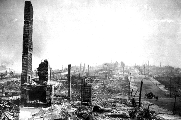
On April 18, 1906, at 5:12 A.M., nearly 400 km (248 miles) of plate boundary snapped into new positions releasing a magnitude (M) 7.9 earthquake. This long seismic event, some 110 seconds in duration, killed 3000 people and caused more than a billion dollars in damage (correct estimates)—exact numbers may never be known because of the post-quake public relations machinery. This great quake caused fires, cracked brick cisterns of badly needed water, and led to near-complete devastation of a major U.S. city that was populated by 400,000 people.

The San Francisco quake triggered the exhaustive Lawson Report, chaired by Andrew Lawson, U.C. Berkeley, which broke much new ground in seismology (The California Earthquake of April 18, 1906: Report of the State Earthquake Investigation Commission: Carnegie Institution of Washington Publication 87, 2 vols.). In the report, the elastic-rebound model described the horizontal nature of faulting in the 1906 event. The response of soft mud and landfill and liquefaction, as compared to sand/gravel, and bedrock bases was mapped. Many lessons were laid out for politicians, academics, and the public (see: https://earthquake.usgs.gov/regional/nca/1906/).

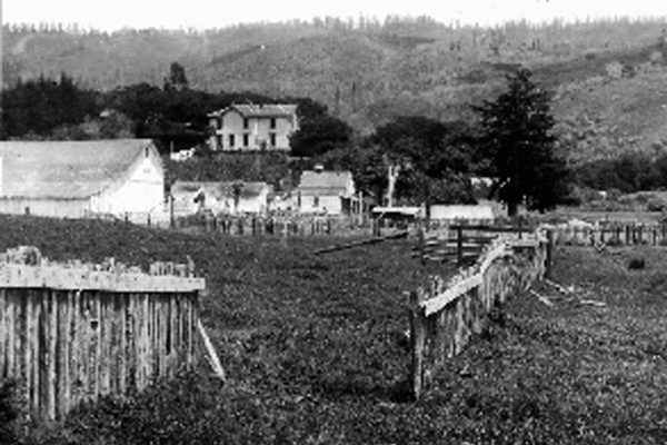
Figure 2a: 1906 fence offset of 2.6 m (8.5 ft) northwest of Woodville, Marin County, showing the right-lateral horizontal movement along the fault line. (Photo from USGS Library.)

As financial and political interests looked ahead from their 1906 vantage point, a collective fear was that the earthquake would forever taint San Francisco. In contrast, after the great 1871 fire in Chicago, the city was rebuilt and better fire-fighting capabilities harnessed. However, what do you do with an earthquake threat? The region around San Francisco experienced major quakes in 1838 and 1868 and no one knew what was to come. For the bulk of the twentieth century following 1906, underreporting death counts and destruction was standard procedure, incorrect estimates of 700 dead and $250 million in damage the fictional report. Corrected estimates were finally published in 1989, ending 83 years of false numbers.

A deliberate decision was made to put up a smokescreen and talk of the great “San Francisco Fire” as the primary event in 1906, and for years it was called “the great fire,” with excess smoke cartooned on B&W photos to sell the label. A century of growth and progress ensued—landfill replaced about half of the surface area of San Francisco Bay to create new real estate, building height restrictions were waved, and growth crawled across known fault zones. The region was all set for the third game of the 1989 Baseball World Series between the San Francisco Giants and Oakland Athletics.

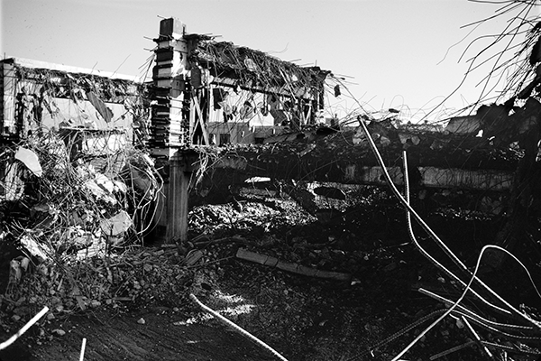
As the players warmed up and sportscasters exercised their voices, disaster struck at 5:04 P.M. (PDT), as a M 7.0 quake rocked the region and Candlestick Park. Areas of landfill around the bay, mapped in the 1908 Lawson Report, failed. The soft muds under a 2 km (1.2 mi) portion of the Route 880 Cypress freeway structure collapsed killing 42 people—unsuspecting victims, listening to the baseball preliminaries on their car radios (Figure 3). A section of the critical San Francisco–Oakland Bay Bridge fell, adding to the combined total damage of $8 billion across the region. The Loma Prieta quake was unique, for as the broadcast signal resumed, a global audience watched the events unfold. Overall, 67 people died in the region.

    Share

AAG Publishes New ‘GeoHumanities’ Journal

This month sees the publication of the first issue of a brand new journal from the Association of American Geographers: GeoHumanities.

GeoHumanities is a new kind of journal, connecting the traditional humanities to both science and the creative arts.

Dr. David Green, Publishing Director International for Routledge Journals, explains: “In the past decade, there has been a convergence of transdisciplinary thought characterized by geography’s engagement with the humanities, and the humanities’ integration of place and the tools of geography into its studies. GeoHumanities journal will now provide the latest, cutting edge information and peer-reviewed research in the field.”

The journal’s editing is being shared by two scholars well qualified for the job. Tim Cresswell is Professor of History and International Affairs at Northeastern University in Boston, as well as Associate Director for Public Humanities at its Humanities Center. Deborah Dixon is Professor of Geography at the University of Glasgow in the UK.

Dixon explains: “GeoHumanities is an opportunity to bring together original, scholarly articles that blur and blend disciplinary specialisms, but that also carve out new lines of inquiry, and new ways of doing research. And, it is an opportunity to present these alongside practice-based commentaries that speak to all manner of timely issues, from the wicked problems of the Anthropocene to the shifting sense of place created by geolocative media.”

In Issue 1, Cresswell notes, “a philosopher considers the role of place in western movies, a creative video artist engages with the politics of the Amazonian forest, a geographer explores the strange history of a perfumer, a poet contemplates the global connections enacted by a desert train, and a historian uses GIS to study eighth century China.”

This exciting new title adds to the AAG’s historic and prestigious portfolio of journals. As Executive Director Douglas Richardson points out, “This new GeoHumanities journal builds on a decade-long AAG initiative to engage research and scholarship at the intersections and convergences of Geography and the Humanities, as well as the recent publication (also by Routledge) of two ground-breaking AAG books examining these trends and interactions.”

Green adds: “It is Routledge’s pleasure to extend our publishing partnership with the AAG. We are most grateful to the Association, and specifically Doug Richardson and the teams of Editors, for continuing to entrust their journals to Routledge, one of the world’s leading geography publishers.”

All content in the first issue is freely available until the end of January 2016. Browse the papers on the Taylor and Francis website. New submissions are welcome at any time. Visit the AAG website for further information and guidelines.

    Share

John Wolter

John Wolter, a cartographer and librarian who served as Chief of the Geography and Map Division at the Library of Congress, passed away on October 22, 2015 at the age of 90.

John Amadeus Wolter was born on July 25, 1925 in St Paul, Minnesota, the eldest son of Amadeus and Marjorie Wolter. He traced his lifelong fascination with maps back to his childhood days when he collected railroad timetables and route maps.

Between 1943 and 1945, Wolter served in the Merchant Marine with the Isthmian Steamship Company, whose vessels had been requisitioned for wartime service. After the Second World War he continued with the company as a deck officer until 1950, voyaging on passenger and cargo vessels to ports in the Red Sea, Persian Gulf, India, Ceylon, Indochina and Indonesia, and from New York west-bound ‘round the world.’

After a brief stint at the College of St. Thomas, Minnesota he entered the United States Army in 1950 starting with service in the Far East during the Korean War.

In 1956 he received a bachelor’s degree in geography from the University Minnesota then spent a year in Washington, DC working as a marine transportation officer for the Military Sea Transportation Service and also undertaking postgraduate studies at Georgetown University. He then returned to the Isthmian Steamship Company for the remainder of the 1950s. During his many years at sea as a navigating officer and cargo officer he used, and made additions and corrections to, a variety of navigational charts and maps.

Back on terra firma in 1960, Wolter returned to the University Minnesota. He served as map librarian, assistant to the director of university libraries, and as lecturer and research fellow in the geography department, as well as completing a master’s degree in library science in 1965. During this time he participated in several Library of Congress Geography and Map Division map processing projects and became familiar with the varied cartographic collections.

In 1966 took a post as assistant professor Wisconsin State University­­–River Falls, teaching geography but only stayed two years until being appointed Assistant Chief in the Library of Congress’s Geography and Map Division in 1968.

Alongside his position in Washington, DC, he carried out doctoral research in geography through the University Minnesota. His dissertation, completed in 1975, was entitled “The Emerging Discipline of Cartography.” Using bibliometric methods, he traced the history of subject bibliographies of cartography back to the nineteenth century, demonstrating the increasing independence and strength of the field of cartography. He also looked at the growth of textbooks and manuals written for students of cartography, and provision for the education and training of cartographers in the US.

In 1978 he was promoted to Chief of the Geography and Map Division, succeeding Wally Ristow, and shortly after oversaw the move of the Division from Pickett Street in Alexandria to the Madison Building on Capitol Hill. It was the first special collections division to make its home in the building and they enjoyed much local and national media coverage given the photogenic nature of maps, charts and atlases.

During his tenure as Chief of the Division, he wrote a number of reference works including an article giving “A Brief History of the Library of Congress Geography and Map Division, 1897-1978,” a co-edited “World Directory of Map Collections,” an article on “Geographical Libraries and Map Collections” in an encyclopedia of libraries, and a piece on “Research Tools and the Literature of Cartography.”

Because of his position, he also sat on many committees including the United States Board on Geographic Names, serving as its Chairman for some time, and the board of directors of the Philip Lee Phillips Map Society aiming to develop, enhance and promote the collections of the Geography and Map Division.

Wolter was also member of many national and international organizations that reflected his interests and specialisms. He was among the founders of the Washington Map Society which was established in 1979 and, under his suggestion, they met in the Geography and Map Division. He was a member of the Society for the History of Discoveries, serving in various executive roles including as President; the International Cartographic Association, including being the US member on its Commission on the History of Cartography; and the International Society for the History of the Map.

He joined the Association of American Geographers in 1961, receiving his 50-year membership in 2011, and he was a member of the International Geographical Union serving two spells on the United States national committee. In addition he was a member of the American Congress on Surveying and Mapping, the North American Society for Oceanic History, the Society for Nautical Research, the Naval Historical Foundation, the American Merchant Marine Veterans, the Disabled American Veterans, the Special Libraries Association, and Theta Delta Chi.

He also served on the editorial boards of CartographicaAmerican CartographerTerrae IncognitaeACSM BulletinSurveying and MappingAnnals of the Association of American Geographers, and was an editorial advisor for The Portolan and a contributing editor to Imago Mundi.

During 1989-90 he took on the additional role of Acting Director for Public Service and Collections Management before retiring from the Library of Congress in 1991. For all his contributions Wolter was recognized with a Presidential citation from the American Congress Surveying and Mapping (1985), an award from the Smithsonian Institute (1986), and a Distinguished Service Award from the Library of Congress (1992).

In retirement he did some consultancy work, continued his research, and gave occasional lectures. Post-retirement publications included three books: Progress of Discovery: Johann Georg Kohl auf den Spuren der Entdecker (1993), Images of the World: The Atlas Through History (with Ron Grim, 1996), and The Napoleonic War in the Dutch Indies: An Essay and Cartobibliography of the Minto Collection (1999).

Wolter leaves behind his wife of 59 years, Joan, and their four sons, Mark, Thomas, Matthew and David.

    Share