Reflections on the State of Geography


Over the last few weeks I have been reading the AAG’s recently released report on the State of Geography. The report observes trends in post-secondary geography education in the United States over the period 1986-2021. These include trends across degree categories, and growth trends among students from populations historically excluded from the discipline. By historically excluded populations, I mean people who have been racialized/minoritized and excluded due to systems of white supremacy. The report confirms some of the concerns about our field’s lack of diversity, offers signs of change, and leaves us with important questions about the nature and constraints of the data collected by the National Center for Education Statistics (NCES). Here I highlight what I think are some of the important takeaways from this report.
What it reveals
A quick overview of the trends shows that the number of geography degrees grew quickly from the 1990s through 2012, but since then, that number has steadily decreased due largely to a decline in bachelor’s degrees. By comparison, masters’ and doctorate degrees have continued to grow. This negative trend in undergraduate geography degree conferral since 2012 reflects a broader downward trend across social sciences, unlike in physical sciences where fields like atmospheric science and conservation are both growing strongly. This is noteworthy because these fields are often found within or combined with geography departments.
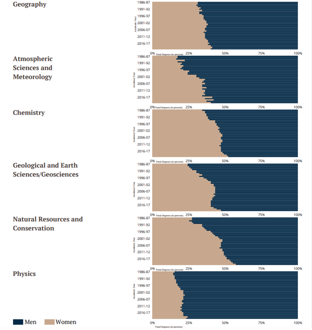
While the number of degrees conferred has fluctuated over the years, the field itself remains predominantly male and white, although women are making inroads at the graduate level. The strength of this finding is undermined by the binary representation of gender in NCES’s and other scientific institutions’ data collection. When I use the term “women” on its own here, I’m referring to a data category and not to individual or collective gender identities that the data do not reflect. With that said, the data show that people reported as women remain underrepresented in geography studies. They do have higher representation in graduate studies (particularly PhDs) than in bachelor’s programs, and a higher rate of growth in PhDs than in master’s or bachelor’s degrees. They also show more consistent positive growth in degree conferral than people identified as men. Overall, besides anthropology and sociology, geography is similar to other social sciences in gender makeup, remaining mostly identified as male.
It is encouraging to see that students in historically excluded populations appear to count for most of the new growth in the discipline, especially at the graduate level. Since 1994, growth in the number of geography degree conferrals has more than doubled among this population, and people identifying as Hispanic or Latinx make up the most rapidly growing proportion at the bachelor’s degree level. Geography degrees are not conferred equitably at any level of the discipline. However, this population’s numbers have grown relative to the total number of combined geography degrees conferred. In fact, it appears that people from historically excluded populations are contributing to any growth that geography is experiencing. Despite this trend, representation in geography PhD degrees is similar to that of other higher education fields, lagging in bachelor’s and master’s degrees. Growth overall has not increased among African American, Native American, and Native Hawaiian or Other Pacific Islander students in recent years.
What it does not reveal
The report gives a picture of the state of geography in the US but also raises questions about the data. The way in which the data were collected/organized limits what can be known. For example, the way the data are organized tends to sidestep intersectional understanding of the discipline and students’ paths through it. Separating out race and ethnicity from gender is a superficial exercise that does not reflect lived reality.
Interpretation of the data should consider that the emphasis on STEM education in the United States has coincided with a decline in social science and humanities majors. Did this affect students’ choice of a geography degree? Perhaps. Geography is not consistently considered a STEM field in US degree-giving institutions. Thus, the emphasis on STEM may mean that students seeking a science career might not major in geography at institutions where it is not considered STEM. Nonetheless, overall trends for master’s and PhD programs show us that geographers seem to be finding their way to the discipline after they earn other bachelor’s degrees.
We also know that the NCES data categories themselves have limitations, especially as geography is such an interdisciplinary field and so rapidly advancing in GIS and other technologies. Many geography programs, in fact, need to or decide to apply non-geography categories to courses and degree paths. In particular, it’s possible that many geography-related programs, (social sciences, environmental sciences, etc.) are reporting GIS degrees or those with heavy loads of GIS coursework under the Computer Science and IT code. The large number of GIS-centric programs in the new AAG Guide database, paired with relatively low numbers of cartography and GIScience degrees conferred, could be evidence of this.
Where to go from here
Studying degree conferrals alone gives us statistical insights that can create the foundation for understanding the discipline’s trends, but it also inspires more qualitative questions about how a geography program’s design, curriculum, approach to recruitment, and faculty/student support can contribute to attracting and retaining a wider variety of students. The AAG is aware of the need for data that have more comprehensive categories and go beyond the quantitative into factors that are more holistic. For example, the AAG is interested in pursuing data that will provide a more detailed picture of gender identities, racialized and ethnic identities, and the disciplinary experiences and conditions that students are encountering. Later this year we will be asking for the geography community’s input into these data. Please respond when you see the call.
I encourage you to read the Report.
I’d like to thank the AAG staff members who prepared the State of Geography report, notably Mikelle Benfield and Mark Revell, for their data analysis, visualizations, and insights.
DOI: 10.14433/2017.0125
Please note: The ideas expressed in the AAG President’s column are not necessarily the views of the AAG as a whole. This column is traditionally a space in which the president may talk about their views or focus during their tenure as president of AAG, or spotlight their areas of professional work. Please feel free to email the president directly at raphael [at] geog [dot] ucla [dot] edu to enable a constructive discussion.

 Representing the definitive reference work for this broad and dynamic field, The International Encyclopedia of Geography: People, the Earth, Environment, and Technology arises from an unprecedented collaboration between Wiley and the American Association of Geographers (AAG) to review and define the concepts, research, and techniques in geography and interrelated fields. Available as an online resource and as a 15-volume full-color print set, the Encyclopedia assembles a truly global group of scholars for a comprehensive, authoritative overview of geography around the world.