New Books: October 2013

Every month the AAG compiles a list of newly-published books in geography and related areas. Some are selected for review in the AAG Review of Books.

Publishers are welcome to send new volumes to the Editor-in-Chief (Kent Mathewson, Editor-in-Chief, AAG Review of BooksDepartment of Geography and Anthropology, Louisiana State University, Baton Rouge, LA 70803).

Anyone interested in reviewing these or other titles should also contact the Editor-in-Chief.

October, 2013
    Share

Julian Bond to Speak at AAG Meeting in Tampa

The Association of American Geographers (AAG) is pleased to announce that Julian Bond, a renowned civil rights pioneer and political leader, has been named the third recipient of the AAG Atlas Award. Professor Bond will receive the award at the AAG’s next Annual Meeting in Tampa, Florida on Friday evening, April 11, 2014, where he will deliver a presentation on “Race Around the World,” focusing on how civil rights figures and organizations have shaped and changed American foreign policy. More than 8,000 geographers and others from around the world, including the media, are expected to attend the AAG meeting.

Julian Bond

Julian Bond
Bond


Bond is the son of former college and university president Horace Mann Bond, and he has built his own record as a celebrated educator, having held appointments at several leading institutions, including American, Harvard, and the University of Virginia. He has been awarded more than 20 honorary degrees throughout his career.
Julian Bond has played a central role throughout the U.S. Civil Rights Movement, as a leading figure in the Student Nonviolent Coordinating Committee and as co-founder and first president of the Southern Poverty Law Center. Bond was repeatedly elected to the Georgia General Assembly for 20 years, including six terms as a state senator. More recently, he has served as Chairman of the NAACP for 12 years, from 1998 to 2010.

Julian Bond embodies the ideals and goals of the AAG Atlas Award, which is designed to recognize and celebrate outstanding accomplishments that advance world understanding in exceptional ways. The image of Atlas bearing the weight of the world on his shoulders is a powerful metaphor for this award program, as the AAG’s awardees are those who have taken the weight of the world on their shoulders and moved it forward, whether in science, politics, scholarship, the arts, or in war and peace. In addition to a substantial cash prize, an Atlas statuette will be presented to Professor Bond as a compelling keepsake and an inspiring symbol for the award program itself. Author and scientist Jane Goodall and human rights leader Mary Robinson are the previous recipients of the AAG Atlas Award.

We invite you to join Professor Julian Bond and the AAG in Tampa to celebrate his extraordinary accomplishments and to discuss with him and others from around the world the future of civil rights and social justice. To register for the meeting, please visit www.aag.org/annualmeeting.

About the Association of American Geographers

The AAG is a scholarly and professional association representing leading researchers, educators, and practitioners in geography. Founded in 1904, its 10,000 members share interests in the theory, methods, and practice of geography, and its role in helping to create a better world. Visit www.aag.org for more information.

    Share

Department of Geography and Planning at University of Toledo Celebrating 50 Years

Although geography classes had been taught at UT in the College of Arts and Sciences since its formation in 1909 — and in later years in various programs by part-time instructors, including within a combined geology and geography department — in September 1963 a stand-alone Department of Geography was established in the College of Arts and Sciences with one full-time geography faculty member, Dr. Byron Emery. The arrival of Dr. William Carlson as the new UT president in 1958 set the stage for the formation of the department due to his interests and experiences with the discipline.

Courses and majors would increase during the 1960s with the addition of Dr. Donald Lewis and a greater focus in economic geography led by Dr. Lawrence (Larry) Hoffman. In fall 1970, the Ohio Board of Regents (OBOR) approved the Master of Arts degree in geography to be offered by the department. By 1973, the department grew to seven full-time faculty members as Drs. Basil Collins, Eugene Franckowiak, Robert Basile and William Muraco also were teaching courses in a variety of areas with special focus on human, economic and urban geography.

Into the 1980s, those “eternal seven” faculty members would advance the department with the growth of the bachelor’s and master’s programs, with several also engaged in University administrative roles and community engagement — a trend that would continue within the department. The master’s program has continued to be the strength of the department and constantly highly ranked nationally with as many as 40 students enrolled at one time, and graduating classes reaching 10 some years. Various department and program reviews would result in expanding to a Department of Geography and Planning and adding specializations in the fields of Geographic Information Systems (GIS), remote sensing, transportation and the environment.

Growth in majors and students in geography courses grew into the late 1990s when the department became a member of the American Collegiate Schools of Planning. In 1996, the department was one of three geography graduate programs invited to participate in a major national study on global change in local places undertaken by the Association of American Geographers. By the late 1990s, with retirements, a number of new members joined the department with an expansion to 10 full-time faculty, adding expertise and courses in environmental geography, cultural geography, urban planning and housing, remote sensing, and weather/climate.

Due to a growing interest and expertise in GIS and related research areas, the department established a lab in the Lake Erie Center in 1998, followed by the creation of the Geographic Information Science and Applied Geographics (GISAG) facility in 2003. Since its formation, the GISAG has secured almost $19 million in external research grant funding to geography faculty and researchers from other UT departments and colleges, and involving the work of dozens of graduate students supported by federal, state and local agencies, including the National Science Foundation, U.S. Department of Agriculture, NASA, U.S. Geological Survey, National Resources Conservation Service, Ohio Environmental Protection Agency, Ohio Department of Transportation, U.S. Army Corp of Engineers, city of Toledo and many others. The GISAG also has developed as an important regional warehouse for geospatial data shared with a number of community partners and agencies.

Recent years have seen continued expansion of the department with the introduction of the Ph.D. program in Spatially Integrated Social Sciences approved by OBOR in 2009. This program is housed and administered by the Department of Geography and Planning and represents a multidisciplinary effort involving the departments of Political Science and Public Administration, Economics, and Sociology and Anthropology — all within the College of Languages, Literature and Social Sciences. By fall 2013, the program has grown to 18 students with anticipation of graduation of the first class this academic year.

2010 marked a significant milestone for the department with a move from the fourth floor of University Hall, which had been its home for many years, to newly renovated and expanded offices, labs and classrooms on the third floor of Snyder Memorial Building. The department has continued to deliver quality courses and programs to majors and students taking both geography and planning courses, while offering opportunities for internships, undergraduate and graduate research, community engagement and outreach via classroom experiences, and student projects.

Throughout its history, the department also has been engaged in numerous campus planning efforts — as highlighted by the often-repeated story of how geography students mapped the footpaths of students crossing Centennial Mall one winter to design the current walkways — and has worked extensively on local community planning for Toledo, Lucas County and various area townships. Graduates have taken careers in a range of fields, with many in local agencies, including TMACOG, Toledo Port Authority, city of Toledo, TARTA and regional planning offices. A number of graduates also have continued onto advanced degrees leading to faculty positions at distinguished universities. Current faculty have received numerous major grants and awards, such as recognition from UT for teaching, research and service; have been active in various administrative roles at the University and college levels; and taken leadership responsibilities with regional, national and international professional organizations, including the Association of American Geographers, National Science Foundation, International Geographic Union, and Regional Science Association.

Presently, more than 60 undergraduate and graduate majors and hundreds of UT students are served by the 10 full-time faculty and three support staff in the Department of Geography and Planning. With the continued interest and growth in international issues, geospatial technologies such as remote sensing and GPS, demand for urban and regional planning, and need for an improved global view, the future for the department and its programs remains strong and positive for another 50 years!

Special events planned during the 2013-14 academic year to celebrate the department’s 50th anniversary include: a special colloquium series featuring distinguished alumni, hosting the 2013 Joint Annual Meeting of East Lakes Division, Association of American Geographers and Canadian Association of Geographers, Ontario Division, 50th Anniversary Alumni Reception, activities for current students, staff and faculty, and special panel sessions at the 2014 Annual Meeting of the Association of American Geographers in Tampa, Fla. For more information on these events, email patrick [dot] lawrence [at] utoledo [dot] edu.

Lawrence is professor and chair of the Department of Geography and Planning.

    Share

NSF Shutdown Notice and Guidance

A Special Message from NSF’s Geography & Spatial Sciences Program Director

The National Science Foundation is in the process of closing our doors for the [U.S. Federal Government] shutdown, and GSS (Geography & Spatial Science) program officers along with all other non-excepted federal employees will not have access to NSF email or systems. FastLane also will not be available. We are very cognizant that our DDRI (Doctoral Dissertation Improvement Grant) deadline is approaching next week on Thursday, October 10. We hope to be open for business by then, but in the spirit of preparation, please note the following and help us inform our community:

1) I have attached the primary guiding documents that your doctoral students and SROs (sponsored research offices) would need to continue working on their submissions: the GPG (Grant Proposal Guide), GSS Solicitation (note especially formatting departures for extra graphics pages and additional review criteria), the overview of the SBE Directorate’s DDRI solicitation (note information on inclusion of indirect costs), and the SBE solicitation (to which GSS students are applying, though again the GSS solicitation instructions supercede those in the SBE DDRI solicitation or GPG where directly indicated). We recognize people are used to these documents being readily available and hope that providing them helps our community.

2) We do not know what the decision will be if shutdown continues after the October 10th deadline, but news of an extension or other such matters will be widely circulated including here on this listserv.

3) Our emails are supposed to be waiting upon us once we re-open, but technical glitches are possible. We ask that you be patient once we re-open and email us again if you have an urgent question, particularly if related to the October 10th deadline. Note you can reach all active GSS POs with one handy address: gss-info [at] nsf [dot] gov (once we re-open, that is!).

Kelley A. Crews, PhD
Geography & Spatial Sciences (GSS) Program Director
Division of Behavioral & Cognitive Sciences (BCS)
Directorate for Social, Behavioral, & Economic Sciences (SBE)
National Science Foundation

    Share

While you are in Tampa, you may notice signage for U.S. Highway 41.

For a walking tour of Calle Ocho in Little Havana visit: https://travel.nationalgeographic.com/travel/city-guides/miami-walking-tour-3/. Map Credit: Hilton Cordoba.

While you are in Tampa, you may notice signage for U.S. Highway 41. Built in the 1920s, it was the only overland route across the southern tip of Florida. U.S. In a larger spatial context, U.S. 41 is a north-south axis that spans the middle of North America and extends from Michigan’s Upper Peninsula to Miami. The southernmost section (Tampa to Miami) is known as the Tamiami Trail. The last few miles of the road are locally known as Calle Ocho (Southwest 8th Street), which forms the main artery and an important boundary within the vibrant multi-ethnic community of Little Havana. The Cuban imprint in ‘Little Havana’ is a cultural layer that simultaneously underlies the current demographic structure of the neighborhood and provides glimpses into the neighborhood’s cultural and historical change.

Before Little Havana

Little Havana has been a common destination for a number of groups that include: Miccosukees, Bahamians Jews, Greeks, Cuban refugees, and immigrants from almost every Latin American country (Shell-Weiss, 2009). Originally, Little Havana consisted of two neighborhoods: Riverside and Shenandoah. Calle Ocho was known as Orange Glades Road that marked a division within the area that is noticeable even today. Riverside, the neighborhood north of Calle Ocho, acquired its name due to its close proximity to the Miami River and was home to some of Miami’s earliest schools, churches, and businesses. Shenandoah (the neighborhood south of Calle Ocho) remained in farmland until the 1920’s when it was developed as a single-family residential area. By contrast, the Riverside the area north of Calle Ocho saw the construction of primarily multi-family housing to meet the needs of number of Jewish people who moved from the Northeast. With them came a landscape comprising a number of synagogues, Sunday schools, Jewish senior homes, as well as numbers of influential leaders who arrived in Miami from the Southeast (George, 2006).

Tower Theater
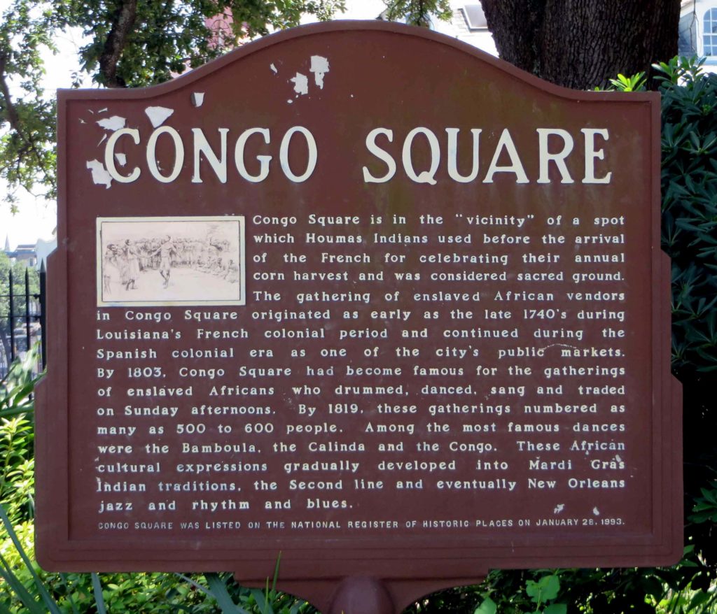
The Tower Theater with its Art Deco style has been a landmark of the neighborhood since it first opened its doors in 1926. Located along Calle Ocho and 15th avenue, the road was a two way street at the time hence the sign of the theater was built at an angle so that it was easy for the drivers to glance quickly at the listing of shows. In the 1960’s with the growth of the Cuban population, the theater was the first one to offer titles in Spanish in Miami-Dade County. Picture Credit: Hilton Cordoba

The making of an enclave

The first wave of Cubans arrived between 1959 and 1962 and became known in the Cuban Community as the ‘golden exiles’ because of the human capital that they brought with them. Many of them were well educated and had business experience. They settled in Riverside and Shenandoah and established businesses and social organizations. In a second wave that occurred from1965 to1973, 3,000 to 4,000 Cubans per month were airlifted to the U.S. Diplomatic preference and easier paths to resettlement were given to those Cubans who had relatives already established in the U.S. During this period Riverside and Shenandoah collectively became known as Little Havana. In this new layer of settlement, many of the apartment buildings that once were occupied by Jews and Anglo Americans were now homes of the newly arrived Cubans. In this cultural an ethnic shift, many of the synagogues were converted into Catholic churches, and the elementary schools’ curricula now featured classes in Spanish (Alberts, 2005). The last major wave of Cuban migration was in 1980 when a boatlift was organized at the port of Mariel; those who embarked on this voyage are sometimes referred as ‘Marielitos’ because of their port of exit. The Cuban population of Little Havana reached its peak with the Census of 1980 when it stood at 95,522. In relative terms that number accounted for approximately 70 percent of the total population and 85 percent of the Hispanics in Little Havana (Cordoba & Carrillo, 2010).

Miami RiverA shot of the Miami River from Jose Marti Park with the I-95 overpass in the background. In the late 1800’s the Miccosukee people navigated the river from the Everglades to come to trade and exchange items with the white settlers. By 1980, the I-95 overpass was the temporary home where the U.S. government created makeshift camps for Cuban refugees that arrived during the Mariel boatlift. In 2008, Jose Marti Park with the Miami River in the background were the setting for a scene in the comedy-drama film Marley & Me. Picture Credit: Hilton Cordoba

From ethnic enclave to multi-ethnic community

Between 1980 and 2000, Little Havana’s Cuban population decreased by 30 percent, and by the 2000 U.S. census, they accounted for 56 percent of Hispanics in Little Havana; estimates of the 2009 American Community Survey showed a slight increase to 58 percent share among Hispanics. Central and South Americans on the other hand, have continued to increase their numbers in Little Havana where now they represent thirty and twelve percent of the Hispanic population, respectively. Nicaraguans and Hondurans account for the two biggest groups from the Central American community while Colombians and Peruvians from the South American community. The fastest growth in the last decade came from the Uruguayans and Argentineans (595 and 318 percent, respectively) as many left for the United States with the collapse of the Argentinean economy in 2001. Little Havana has changed as the different groups that have come through the area have made it their home. Nicaraguans have especially acquired an affinity for Little Havana as you can find their fritangas (cafeteria style restaurants serving Nicaraguan food and specialty drinks) at almost every major intersection, a street name after Nicaraguan poet Ruben Dario, the offices of the Nicaraguan consulate, the mausoleum of former Nicaraguan president Anastasio Somoza Debayle, and St. John Bosco Catholic Church and its Nicaraguan parishioners.

FritangaFritangas are found throughout the streetscape of Little Havana. These restaurants are not just about the ethnic dishes but also a place to gather news about the homeland or the local community, buy phone cards to call relatives, a place to find souvenirs and delicacies imported from Nicaragua, and even a place of worship on the evening of every December 7th when Nicaraguans celebrate ‘la griteria’ (a chanting to the Immaculate Concepcion of the Virgin Mary, a tradition that dates back to colonial times). Picture Credit: Hilton Cordoba

The centrality of Little Havana is often most overlooked but helps explain why this area has been sought out by so many immigrants and helps us understand why it continues to be the residential area of choice of many Hispanic seniors. Businesses along Southwest 8th Street, West Flagler Street and other major roads not only prevent residents from having to go outside the neighborhood for goods and services, but also make it easy to live in the area without dependence on the automobile. This centrality also creates locational advantages in access jobs: Little Havana is in the vicinity of higher income areas, which are the workplace for many immigrants who live in the neighborhood. Areas such as Brickell, Coconut Grove, Key Biscayne, and Miami Beach, are luxury condominium communities, with extravagant homes, and hotels that provide work for many immigrants who find positions as maids, gardeners, and construction workers. These workers capitalize on a huge cultural benefit of not having to learn a new language; many can live in Little Havana without ever learning English. The combination of these unique characteristics creates a safe haven for immigrants and the perfect gateway for those in search of a new life in America.

There is more to Little Havana than the name suggests, so when you come across U.S. route 41 in Tampa, think about the lively multi-ethnic neighborhood at the southern end of the road. You can venture out along the Tamiami Trail and cross the Everglades as the famous Trail Blazers did in early 1920’s. You will have a chance to stop by the Miccosukee village, catch an airboat ride, or hop on a bike to explore the Everglades on a 15 mile loop at Shark Valley. If you prefer not to drive, you may take the 92 Silverstar and enjoy a train ride through the verdant back country of Florida; whatever you decide to do, just bring a camera along to capture the unique streetscape and a hearty appetite for the endless variety of Latin food that await you in Little Havana.

Hilton Cordoba

Geosciences Department

Florida Atlantic University

DOI: 10.14433/2013.0019


References

Alberts, Heike C. (2005). “Changes in Ethnic Solidarity in Cuban Miami”. Geographical Review 95(2). P 231-248. DOI: 10.1111/j.1931-0846.2005.tb00364.x

Cordoba, Hilton & Carrillo, Jose. (2010). “Neighborhood Change in Miami’s Little Havana; A Demographic Analysis from 1970 to 2000”. The Florida Geographer. 41. P 65-88.

George, P.S. (2006). Images of America: Little Havana. Charleston, SC: Arcadia Publishing.

Shell-Weiss, M. (2009). Coming to Miami: A Social History. Gainesville, FL: University Press of Florida.

United States Census Bureau. (2009). American FactFinder. Retrieved from https://factfinder2.census.gov/faces/nav/jsf/pages/index.xhtml

    Share

New Books: September 2013

Every month the AAG compiles a list of newly-published books in geography and related areas. Some are selected for review in the AAG Review of Books.

Publishers are welcome to send new volumes to the Editor-in-Chief (Kent Mathewson, Editor-in-Chief, AAG Review of BooksDepartment of Geography and Anthropology, Louisiana State University, Baton Rouge, LA 70803).

Anyone interested in reviewing these or other titles should also contact the Editor-in-Chief.

October, 2013
    Share

TAMPA!

Now is the time to begin planning for the AAG annual meeting, one of the largest venues in the world for sharing and communicating the broad range of contributions by geographers to basic and applied knowledge and to problem solving. The 2014 annual meeting will be held April 8-12 in Tampa, Florida. This is the first annual meeting to be held in the southeastern United States in over a decade and the first ever in Tampa. The excitement of a new venue, coupled with the intellectual stimulation that we all expect of an AAG annual meeting, promise to make the 2014 AAG annual meeting particularly noteworthy.

The AAG annual meeting traditionally has a number of featured themes that help to provide some structure to this diverse and rich meeting. Some of the featured themes emerge organically as the Local Arrangements Committee and the AAG meeting staff organize the thousands of abstracts and hundreds of special sessions submitted for the conference. Other themes are provided directly by AAG members, and I invite all of you to suggest provocative and engaging themes for the Tampa meeting. The setting of the meeting itself suggests numerous potential themes including environmental hazards, emigration, the aging of America, among others. There are many other current issues and developments that merit consideration as a featured theme, and I encourage you to submit suggestions.

In addition, the AAG Executive Committee and Executive Director have developed three overarching, “core” themes for the Tampa meeting that we believe are of sufficient interest to engage all meeting participants, that are of themselves interconnected and cross the human, physical and methods dimensions of the discipline, and that, most importantly, are of such weight and significance that collective focused attention is warranted. These themes are “Geographies of Climate Change,” “Racism and Violence in America: Fifty Years since the March on Washington for Jobs and Freedom” and “GIScience, GIS, and Public Policy.”

Climate change is one of a myriad of environmental concerns facing humankind today and is representative of the inherent scientific complexity and uncertainty of these concerns, their political and policy contextualization, the challenges of formulating adaptation and mitigation strategies, and the importance of effective communication. The “Geographies of Climate Change” theme was selected to highlight the complex scale interactions of climate change including the observed and anticipated spatial differentiation in potential impacts and vulnerability. The Presidential Plenary session on the opening day of the conference will “kick off” this theme. Presenters include: Mike Hulme, founding director of the Tyndall Center for Climate Change Research and currently Professor of Climate and Culture in the Department of Geography at King’s College London, and author of Why We Disagree about Climate Change; Linda Mearns, director of the National Center for Atmospheric Research Weather and Climate Impacts Assessment Science Program, and project leader of the North American Regional Climate Change Assessment Program (NARCCAP) which is providing high-resolution climate change projections for the impacts community; Susanne Moser, an independent researcher and consultant on adaptation, science-policy interactions, decision support, and climate change communication; and J. Marshall Shepherd, the current president of the American Meteorological Society and a faculty member in the Department of Geography at the University of Georgia, whose research focuses on urban influences on climate. Numerous other sessions on the “Geographies of Climate Change” will be held throughout the annual meeting, and I urge you to keep this theme in mind as you submit an abstract and/or propose sessions.

I am writing this column on the anniversary of Martin Luther King’s March on Washington for Jobs and Freedom. Fifty years have passed since that landmark event, and many of the commemorative addresses acknowledge the considerable progress that has been made with respect to civil rights over the past half century. However, Florida is the location of a harsh and sorrowful reminder of the continuing pervasiveness of racism and violence in the United States. We would be remiss, while in Tampa, to not collectively consider the broader implications of the death of Trayvon Martin and the complex and disturbing trial that followed, and to explore our potential contributions to a path forward. Hence, a core theme of the meeting is “Racism and Violence in America: Fifty Years since the March on Washington for Jobs and Freedom.“ Fifty years ago the March participants sought comprehensive civil rights legislation, desegregation of public schools, greater access to employment for all groups, and an increased minimum wage. The featured theme for the AAG annual meeting provides an opportunity for us to explore past, current, and potential future contributions of geographical research to understanding and addressing progress in these and related areas. It will also enable all of us to reflect on our personal actions and commitment to reducing racism and violence. AAG Past-President Audrey Kobayashi and Professor Joe Darden from Michigan State University are leading the planning effort for a collection of plenary and special sessions and public events around this featured theme, and they request your input and suggestions.

The potential for GIScience to contribute to the formation of public policy has been demonstrated, but not fully realized. The third core theme, “GIScience, GIS, and Public Policy” will explore the expanding role of GIScience in the public policy arena, both generally and also with respect to climate change and racism and violence. This theme also encompasses another dimension, that of federal and state policy-making regarding GIS itself. In particular, the roles of the Federal Geographic Data Committee (FGDC) and the National Geospatial Advisory Committee (NGAC) in developing a new strategic plan for the U.S. National Spatial Data Infrastructure (NSDI) will be highlighted during several special sessions. Again, your assistance in contributing papers and posters, and organizing special sessions around the featured theme of “GIScience, GIS, and Public Policy,” is requested.

As noted above, the featured themes attempt to provide some structure to a large, exciting, highly attended meeting. But, as always, the AAG annual meeting is an open meeting, and I look forward to your contribution to the meeting and to being submerged in the diverse set of paper and poster topics that we all expect at our annual meeting. Instructions for submitting abstracts and special sessions are found at http://www.aag.org/cs/annualmeeting. Keep in mind that the “early bird” registration discount ends October 23.

See you in Tampa!

–Julie Winkler

DOI: 10.14433/2013.0016


    Share

Essential Geographies of New Orleans Music

Part 1: Congo Square, Atlantic Exchange, and the Emergence of Jazz

New Orleans is a meeting ground. Situated at the confluence of the Mississippi River and the Gulf of Mexico, the city connects North America’s most expansive riverine network with the vast Atlantic basin. Its strategic location has long attracted diverse peoples and ideas, whose collaborations have forged extraordinary cultural, economic, and ecological innovations. Prominent among those novel expressions, music remains central to New Orleans’ sense of place. This essay, offered in two parts, surveys the cultural and historical geographies of music in New Orleans. It outlines a rough chronology of the innovative musical cultures that coalesced and continue to proliferate in New Orleans, emphasizing both the singularity of the city’s cultural production, as well as its fundamental connections with the French, Hispanic, and Black Atlantics.[1] This geographical treatment will, I hope, prime attendees of the 2018 AAG Annual Meeting to indulge in New Orleans’ rich musical (and other performative) cultures on display at countless clubs, bars, restaurants, parties, parades, and street corners, as well as the French Quarter Music Festival. Overlapping with the AAG conference and free of charge (!), the lively outdoor fête showcases some of the region’s most celebrated acts and styles. In this first of two parts, I treat the city from its founding in the early-eighteenth century through the emergence of jazz in the early-twentieth century, providing historical-geographical context for the distinct and diverse musical cultures emanating from New Orleans.

New Orleans and its musical cultures are perhaps best understood through the city’s complex connections to the African diaspora, its experiences within the French and Spanish Colonial Empires, and its relations to fluvial networks and ports throughout the mainland Americas and the Caribbean. After founding the city in 1718, France ceded New Orleans to Spain in 1762. The city spent four formative decades under Spanish control, undergoing significant demographic, urban, and economic growth. Napoleonic France briefly regained control of the city in 1803 before selling it to the United States just three weeks later in the Louisiana Purchase. As the colony changed hands over the eighteenth and nineteenth centuries, a steady flow of enslaved Africans continually replenished profound African influence in New Orleans and its environs. Those fundamental influences continue to manifest in the city’s rich cultural and economic development, especially by way of its music.[2]

The historical-geographical hearth of musical culture in New Orleans (and, it could be said, of the US as a whole) is Congo Square—the first and only sanctioned gathering place for enslaved people in the antebellum United States—beginning as early as the 1740s (Figure 1). Located just outside of the original city walls, near the grounds of the Tremé Planation, Congo Square originated as a Sunday market where enslaved Afro-descendants and indigenous people gathered to trade in goods they themselves had grown, gathered, and hunted. The weekly gatherings soon became an extraordinary venue for cultural exchange where hundreds of people mingled, cooked, drummed, worshipped, danced, and sang. Spirituality was fundamental in those musical and rhythmic expressions, as drumming remains essential in the syncretic religions that developed among Afro-descendants in the New World, among them Vodun in Haiti, Santeria in Cuba, and Voodoo and Hoodoo in New Orleans.[3]

Beginning in the French period, Congo Square and its weekly assemblies survived and evolved through Spanish control and later the city’s integration into the United States. By the early nineteenth century, visitors documented crowds numbering more than 500 practicing distinct forms of African drumming, singing, and dancing. The humble outdoor market became a historic nexus crucial for the preservation of African cultural forms, as well as the eventual creation of novel hybrids mixing, as just one example, Senegambian-style banjos with drumming from the Kongo. Congo Square thus remains an important site of African-American cultural and economic resistance where enslaved people of African descent, despite the horrific brutalities of slavery, laid the rhythmic foundations for what eventually became blues, ragtime, jazz, country, rhythm and blues, rock and roll, hip hop, and countless other American musical genres. As prominent New Orleans jazz musician, educator, and advocate Wynton Marsalis proclaimed, “The bloodlines of all important modern American music can be traced to Congo Square.”[4]

A plaque commemorating Congo Square in Louis Armstrong Park where the French Quarter and Tremé neighborhoods meet at Rampart and Orleans Streets (Photo credit: K.D. Burns, 2012).

While many New Orleans traditions trace their beginnings to Congo Square, the various groups collectively known as Mardi Gras Indians maintain a particularly firm link to the traditions forged there. Melding West African, Indigenous American, and European Catholic traditions, the Mardi Gras Indians celebrate the pre-Lenten Carnival (and a few other dates) by creating, costuming, and parading in lavish handmade regalia adorned with thousands of sequins, beads, and feathers (see Figure 2). Keepers of extravagant musical and material traditions traceable to Yoruba and Haitian Afro-creole antecedents, the Indians remain influential community leaders in many neighborhoods of New Orleans. (See Part II of this essay for more on the Indians’ musical influence).[5]

New Orleans Mardi Gras Indians “masking” in the Lower Ninth Ward. Image courtesy of House of Dance and Feathers, a local museum (consider visiting and supporting them).

New Orleans’ distinct musical traditions began to coalesce during the Spanish period (1763-1803) when colonial trade and administrative networks linked the city with Vera Cruz, Tampico, and especially Havana, then the seat of the Spanish American colonies. Military-style marching bands provided the basic instrumentation and arrangements for the region’s music, as well as public spectacles. When Spanish Governor Miro received a delegation of Choctaw and Chickasaw Indian chiefs in 1787, he wooed them with a ballroom dance and an extravagant military parade.[6]

The following decade, refugees fleeing the Haitian (Saint Domingan) Revolution—roughly equal thirds White creole, enslaved, and free people of color—began streaming into New Orleans. Bringing with them African-inspired spiritual and musical traditions forged in the French Atlantic, the refugees doubled the city’s size by 1810. To keep up with the abrupt population growth, New Orleans quickly expanded its footprint north of the original city into former lands of the Tremé plantation, creating the faubourg (neighborhood) of the same name, where many Haitians and other émigrés eventually settled.[7]

Born in New Orleans, antebellum piano prodigy Louis Moreau Gottschalk grew up studying music with his grandmother Bruslé and her enslaved nurse Sally, both natives of Saint Domingue, before travelling widely in the Caribbean and Latin America. His piano composition “Bamboula, Danse des Nègres” (1848) drew on African-inspired folk traditions from the Antilles, and melded seamlessly with the rhythms of Congo Square. Written in Martinique in 1859, his “Ojos Criollos, Danse Cubaine” (Creole Eyes, Cuban Dance) blended Afro-Cuban rhythms with European melodies to foreshadow ragtime by three decades. By the mid-19th century, many widely popular musical styles—from minstrel show tunes, ragtime, and cakewalks to Cuban habanerarumba, and son clave—all shared syncopated two-hand piano riffs made popular by Gottschalk. Those rhythms served as a foundation for later styles, including jazz, and live on not only in New Orleans’ second line parades and Mardi Gras Indian gatherings, but also the comparsa and conga processions of Cuban Carnival.[8]

Essential to the city’s musical traditions, brass bands were already integral to public life in New Orleans by the early nineteenth century. In 1838 the daily Picayune proclaimed a “mania in this city for horn and trumpet playing” derived from military bands and processions. Following the Civil War, that instrumentation combined with African-inspired funeral celebrations to lay the groundwork for New Orleans jazz funerals and second lines. Adding to the mix were post-abolition waves of African-American workers who migrated to the city in search of economic opportunities, bringing along their canon of work songs, spirituals, and blues from the Mississippi Delta. There the sacred call-and-response musical aesthetic of the Plantation South encountered the widely popular dance craze known as ragtime, and together began filtering through New Orleans’ traditional brass instrumentation and syncopated African rhythms.[9]

By century’s end, changes in the city’s legal frameworks would unwittingly galvanize the music scene in New Orleans, and provide the final ingredients for the musical gumbo that would coalesce as jazz. After the landmark Supreme Court decision Plessy v. Ferguson codified racial segregation into a strict binary, mixed race creole musicians found themselves officially classified as Blacks. An unforeseen consequence of that terrible ruling was the integration of the city’s brass bands, unifying creole musicians and their classical training with the more freewheeling styles of the city’s Black blues musicians. The following year, in 1897, the New Orleans city council created the city’s red light district where prostitution, drugs, and gambling were regulated and confined. The rough-and-tumble Storyville district provided steady gigs for brass bands and piano players at the end of the nineteenth century. Located in the Faubourg Tremé just two blocks from the site of Congo Square, the district became ground zero for a revolution in American music (Figure 3).[10]

Postcard showing view of Storyville; New Orleans: C. B. Mason, [1904–8]; The Historic New Orleans Collection, 1979.362.16

Emanating from New Orleans around the turn of the twentieth century, the novel improvisational styles that would collectively become known as jazz emerged from essential connections with the Mississippi Delta, Latin America, and the Caribbean. First visiting the city as part of the New Orleans World’s Fair of 1884–85, several Mexican bands and musicians became legendary for their lasting effects on the city’s musical cultures, including the introduction of the saxophone, bass plucking, and original compositions. Members of the Onward Brass Band, then among New Orleans’ most prominent marching bands, traveled to Cuba during the Spanish-American War. Among them were trombonist Willie Cornish and alto horn player John Baptiste Delisle, musicians that also played with Charles “Buddy” Bolden, a (the?) forerunning jazz musician. By the turn of the 20th century, jazz pioneers Bolden, Joe “King” Oliver, and Jack “Papa” Laine were collaborating with musicians with strong ties to Cuba, such as Manuel Pérez and Manuel Mello.[11]

The second generation of New Orleans jazz musicians could still discern the Afro-Latin influences fundamental to the jazz sound. Citing what he called “little tinges of Spanish,” New Orleans pianist Ferdinand “Jelly Roll” Morton, himself a descendant of creole Haitian émigrés, credited habanera rhythms as essential elements in New Orleans jazz. Another member of the second generation, the great Louis Armstrong, got his start in Storyville where he played in bands led by Kid Ory and King Oliver. Their repertoire included “New Orleans Stomp,” a popular dance tune steeped in complex Afro-Caribbean rhythms and time signatures.[12]

Jazz thus emerged in New Orleans as a delicious gumbo of ragtime, Delta blues, and the diasporic rhythms of the Afro-Caribbean. Despite continuous growth and innovation, most New Orleans music still derives from fluid blends of syncopated rhythms celebrated in Congo square and countless Afro-Caribbean communities with Eurasian instrumentation and melodic forms. The genius of New Orleans’ music springs not from the spontaneous epiphanies of a few talented individuals, but instead crystallizes from the city’s fluid connections to other places. At the confluence of the French, Spanish, and Black Atlantic Worlds, New Orleans has long provided an inclusive venue for the integration of diverse cultural forms.

New Orleans will forever be associated with jazz, yet the soundtrack of the contemporary city is more complex. While people of all ages continue to enjoy an ever-expanding array of expressions falling under the jazz umbrella (e.g. Dixieland, trad jazz, Latin jazz, avant-garde jazz, jazz-funk, and various fusion sounds), New Orleans remains devoted to a grand diversity of musical genres and styles, such as brass bandsR&Bsoulfunkrock and rollheavy metalhip hopbounce, and even zydeco—an upbeat Afro-French creole dance music from west of the Atchafalaya. In part two of this essay (coming early 2018) I discuss several of those musical traditions as they emerged in New Orleans since the twentieth century, with special emphasis on the artists and styles on display at the 2018 French Quarter Music Festival (Figure 4) that overlaps with the AAG annual meeting.

New Orleans blues guitarist Little Freddie King jams with Big Chief Juan Pardo of The Golden Comanche Mardi Gras Indians at the French Quarter Festival near Woldenberg Riverfront Park, 2015. Photo credit: Zack Smith, courtesy of French Quarter Festival.

Further reading and listening: To begin your preparations for New Orleans, be sure to live stream WWOZ, New Orleans community radio and self-proclaimed “Guardians of the Groove.” For more on New Orleans music, see the works referenced in the notes below and the following resources: recordings posted online by the Smithsonian Folkways Magazine, a YouTube playlist of recordings of Mardi Gras Indians compiled by the Alan Lomax archive; and a YouTube playlist of New Orleans music compiled by the author. Finally, I cannot recommend enough A Closer Walk, an interactive website, map, and series of guided tours of the geographies of New Orleans music, sponsored by WWOZ and others.

— Case Watkins, James Madison University

DOI: 10.14433/2017.0013


[1] With those terms I follow a wealth of scholarship on the interconnected Atlantic Worlds, especially their connections to the African diaspora, the French and Spanish colonial empires, and the territories and communities they helped shape. See Paul Gilroy, The Black Atlantic: Modernity and Double Consciousness (Cambridge: Harvard University Press, 1993). Douglas R. Egerton et al., The Atlantic World: A History, 1400 – 1888 (Malden: Wiley-Blackwell, 2007). William Boelhower, ed., New Orleans in the Atlantic World: Between Land and Sea (London: Routledge, 2010).

[2] Andrew Sluyter et al., Hispanic and Latino New Orleans: Immigration and Identity Since the Eighteenth Century (Baton Rouge: Louisiana State University Press, 2015). Gwendolyn Midlo Hall, Africans in Colonial Louisiana: The Development of Afro-Creole Culture in the Eighteenth Century (Baton Rouge: Louisiana State University Press, 1995).

[3] Ned Sublette, The World That Made New Orleans: From Spanish Silver to Congo Square (Chicago: Lawrence Hill Books, 2008). Michael Crutcher, Tremé: Race and Place in a New Orleans Neighborhood (Athens: University of Georgia Press, 2010). Freddi Williams Evans, Congo Square: African Roots in New Orleans (Lafayette: University of Louisiana at Lafayette Press, 2011).

[4] References in note 3. Benjamin Henry Latrobe, Impressions Respecting New Orleans: Diary and Sketches, 1818-1820, ed. Samuel Wilson Jr. (New York: Columbia University Press, 1951). Quote on the jacket for Evans, Congo Square.

[5] Michael P. Smith, “Behind the Lines: The Black Mardi Gras Indians and the New Orleans Second Line,” Black Music Research Journal 14, no. 1 (April 1, 1994): 43–73. DOI: 10.2307/779458 Michael P Smith, Mardi Gras Indians (Gretna, LA: Pelican Publishing Company, 1994). Richard Brent Turner, Jazz Religion, the Second Line, and Black New Orleans (Bloomington: Indiana University Press, 2009).

[6] Charles Gayarré, History of Louisiana, Vol. 3 (New York: Redfield, 1885). William Schafer, Brass Bands and New Orleans Jazz (Baton Rouge: Louisiana State University Press, 1977).

[7] Sublette, The World that Made New Orleans. Crutcher, Tremé.

[8] S. Frederick Starr, Bamboula! The Life and Times of Louis Moreau Gottschalk (New York: Oxford University Press, 1995). Jack Stewart, “Cuban Influences on New Orleans Music,” Jazz Archivist 13 (1999): 14–23. Turner, Jazz Religion. Sublette, The World that Made New Orleans.

[9] Schafer, Brass Bands. Sybil Kein, “The Celebration of Life in New Orleans Jazz Funerals,” Revue Française D’études Américaines, no. 51 (1992): 19–26. Donald E DeVore, Defying Jim Crow: African American Community Development and the Struggle for Racial Equality in New Orleans, 1900-1960 (Baton Rouge: Louisiana State University Press, 2015).

[10] Al Rose, Storyville, New Orleans: Being an Authentic, Illustrated Account of the Notorious Red-Light District (Tuscaloosa: University of Alabama Press, 1974). Charles Hersch, Subversive Sounds: Race and the Birth of Jazz in New Orleans (Chicago: University of Chicago Press, 2007). City leaders demolished Storyville in 1940 to make way for the New Deal era Iberville Housing Projects, which are currently being redeveloped as mixed-income apartments.

[11] Jack Stewart, “Cuban Influences on New Orleans Music.” Jack Stewart, “The Mexican Band Legend: Myth, Reality, and Musical Impact; A Preliminary Investigation,” Jazz Archivist 6, no. 2 (1991): 1–14. Jack Stewart, “The Mexican Band Legend–Part II,” Jazz Archivist 9, no. 1 (1994): 1–17. John McCusker, “The Onward Brass Band in the Spanish American War,” Jazz Archivist 13 (1998-1999): 24-35. Schafer, Brass bands.

[12] Ferdinand “Jelly Roll” Morton, Jelly Roll Morton: The Complete Library of Congress Recordings by Alan Lomax, Music CD (Cambridge, MA: Rounder Records, 2005): Disc 6, Tracks 8 and 9. Stewart, “Cuban Influences.” Louis Armstrong, Satchmo: My Life in New Orleans (New York: Da Capo Press, 1986).

    Share

Obama Nominates Cordova to Lead NSF

Obama Nominates Córdova to Lead NSF; Gutmann Departs SBE Post

On July 31, President Obama nominated astrophysicist Frances Córdova to serve a six-year term as Director of the National Science Foundation (NSF).  Córdova is President Emerita of Perdue University and led the school from 2007-2012.  She is also a former Chancellor of the University of California, Riverside.  Córdova holds a BA from Stanford and a PhD from the California Institute of Technology.  The previous NSF Director, Subra Suresh, left the agency this spring to assume the presidency at Carnegie Mellon.  Córdova must be confirmed by the Senate before she can take office.

Also at the Foundation, Myron Gutmann’s final day as Assistant NSF Director and head of the Social, Behavioral, and Economic (SBE) Sciences Directorate was August 16.  Joanne Tornow, Deputy Assistant Director for SBE, will lead the Directorate in an acting capacity until Gutmann’s replacement is hired.

House Passes ESEA Reauthorization Bill Without Including New Geography Programs

On July 19, the House of Representatives passed H.R. 5, the Student Success Act, which would serve to re-write the Elementary and Secondary Education Act (ESEA).  The ESEA, which is currently known as No Child Left Behind (NCLB), is the major federal law governing K-12 education and hasn’t been reauthorized since January 2002.  The law technically expired in 2007, but it remains in effect pending a new enactment.

The party-line vote in favor of H.R. 5 was 221-207.  Most House Republicans supported the bill, but 12 GOP members joined a united Democratic caucus in opposing the legislation.  Rep. John Kline (R-MN), Chairman of the House Committee on Education and the Workforce, proclaimed, “The Student Success Act will tear down barriers to progress and grant states and districts the freedom and flexibility they need to think bigger, innovate, and take whatever steps are necessary to raise the bar in our schools.”

The Committee’s Democratic staff countered with a statement decrying the partisan nature of the vote. “We can’t shortchange our nation’s future by shortchanging our kids — we need to pass a better education bill in Washington,” Rep. Carolyn McCarthy (D-NY) said in the statement. “The majority’s ESEA bill lacks the funding and accountability that America’s youth need to get a world-class education and compete in a global economy.”

Similar to NCLB and previous versions of the ESEA, the Student Success Act does list geography as a “core academic subject” for K-12, but the bill does not include any new programs to support the teaching of geography.  Due to the partisan nature of the vote, H.R. 5 is unlikely to find favor in the Democratic-controlled Senate.  Senator Tom Harkin (D-IA), who chairs the Health, Education, Labor, and Pensions (HELP) Committee, has introduced an ESEA reauthorization bill of his own:  The Strengthening America’s School Act of 2013 (S. 1094).  Harkin’s legislation also fails to authorize any new geography education programs, but the proposal must still go through HELP hearings and actions, in addition to time on the Senate floor before it could be voted on.

Even if the Senate does pass some version of S. 1094, the two Houses of Congress would have to reach agreement on a compromise bill.  Given the gridlock that has gripped Capitol Hill throughout the year, prospects appear dim.  Several outside observers have indicated that the ESEA reauthorization may be pushed back again, possibly even until 2015.  We will keep you apprised of any key developments.

FedEx, Three Governors Endorse AAG Resolution 

In related news, the “AAG Resolution Supporting K-12 Geography Education” has garnered some additional high-profile endorsements in recent weeks.  The document explains the value and importance of geography education and urges federal policymakers to include funding for geography as part of a reauthorization of the ESEA; to include geography and geospatial education in Science, Technology, Engineering, and Mathematics (STEM) proposals; and to enhance geography teacher training.  In recent weeks, the resolution has been endorsed by:

  • FedEx Corporation is the world’s largest express transportation company and has over 300,000 employees worldwide.  A mainstay in the Fortune 100, FedEx was founded in 1971 and serves more than 220 countries and territories.
  • Governor Steve Bullock (Montana) took office in January, having served previously as Montana’s Attorney General.  He campaigned on the importance of job creation and told the AAG in a letter that he was endorsing the resolution in part because of the needs for geographic skills in a wide range of employment categories in his state.
  • Governor Alejandro García Padilla (Puerto Rico) was elected as the Commonwealth’s chief executive in 2012.  He has also held office in the Senate of Puerto Rico and as the island’s Secretary of Consumer Affairs.
  • Governor Maggie Hassan (New Hampshire) has led the Granite State since January.  She served in the New Hampshire Senate for six years, including a two-year period as Majority Leader.  Her husband, Thomas, is principal of the highly-regarded Phillips Exeter Academy.

Also of interest, another endorser of the resolution, retired Navy Vice Admiral Dennis McGinn, was confirmed on August 1 as President Obama’s pick to serve as Assistant Secretary of the Navy for Energy, Installations, and Environment.  McGinn had been president of the American Council On Renewable Energy prior to his nomination. We appreciate the support of FedEx and the three Governors and we wish Admiral McGinn the best as he returns to public life.

John Wertman

    Share

New Books: August 2013

Every month the AAG compiles a list of newly-published books in geography and related areas. Some are selected for review in the AAG Review of Books.

Publishers are welcome to send new volumes to the Editor-in-Chief (Kent Mathewson, Editor-in-Chief, AAG Review of BooksDepartment of Geography and Anthropology, Louisiana State University, Baton Rouge, LA 70803).

Anyone interested in reviewing these or other titles should also contact the Editor-in-Chief.

October, 2013
    Share