The New England Town: Not a Village

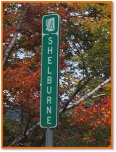
Fig.1. Town Line, Shelburne, New Hampshire.
Photo and permission by Betty Austin.

The New England town and its town meeting form of government invoke images of roadside town line signs and real democracy playing out on the floor of a wood stove heated frame town house in a small town somewhere in Boston’s hinterlands (fig.1). The New England town is a municipality that encompasses an expanse of land and usually includes compact settlements (villages /hamlets) and rural areas. These political units evolved from the seventeenth century needs of people transplanting themselves from England to the shores of Massachusetts Bay. Demands of church and civic governance resulted in a blending of religious and town government affairs in early Massachusetts. John Winthrop, first governor of the Massachusetts Bay settlements that would develop in and around the Boston locale was a principal player in both Congregationalism and establishing the underpinnings of New England town formation and administration (Rudman 1965). Towns were charged with providing local services: laying out roads and maintaining them, education, police and fire protection, overseeing the poor, passage of ordinances to protect public health and promote the general welfare of the population. These municipalities were also authorized to raise taxes to support their functions. New England colonies established policies that encouraged contiguous settlement as the frontier advanced. This provided for better safety from both external and internal dangers. Indians and foreign powers presented threats from time to time. On the domestic front church and community leaders wanted to watch over their people to ensure no citizen strayed from social norms. Hester Prynne with her scarlet letter and the banishing of Roger Williams from Massachusetts are examples of the latter (Hawthorne 1850; Barry 2012). As time passed villages within the towns became the visual icon of much of the region (Wood 1997). However, even with villages, some quite large, the town continued to be the government (Murphy 1964). If growth or political pressure resulted in city status the city line conformed to the pre-existing town line. Colonies and later states made provisions for town lines to change as development and population patterns evolved. In some situations towns reverted to unorganized townships if loss of population dictated.

Towns in New England range in geographic area from a few hundred acers in the case of some island communities and compact urban areas to a more typical size of six miles by six miles or thirty-six square miles. This larger size represents the approximate service area of a colonial church or seat of town government. Most traffic was by foot or animal. Topography and barriers to travel were often considered in laying out town lines. Towns were created from unincorporated land by colonial and later state governments. As land came under private ownership and underwent settlement, towns were incorporated upon petition of the owners and residents. In some situations plantations (planting a settlement) were formed by the colonial or state government. Plantations have fewer home rule powers then towns and are an intermediate step to becoming a town. The official name of the State of Rhode Island is Rhode Island and Providence Plantations. Our smallest state has the longest name. With population growth most plantations eventually became towns. Maine still has a few dozen of them. Many towns skipped ever being a plantation. Maine plantations have the powers of towns except they cannot enact land use ordinances without permission of the state. Most of New England is divided into towns. Larger places and some mid-sized municipalities have become cities. Cities have more complex governments than towns and this varies among states. Nearly half of Maine (most of its north and northwest) is comprised of surveyed but unincorporated townships. All have either small populations or no people.

Fig.2. Freedom of speech at a recent open town meeting in Maine.
Source: Waterville (ME) Morning Sentinel.

Towns that arose in the six New England states were governed by the open town meeting where a legislative body comprised of all voting citizens of the town gathered at annual or special meetings to transact the legal affairs of the town. Many small and mid-sized towns continue to conduct their business through open town meetings with each citizen representing himself/herself on the floor. Larger towns and cities have councils or town meetings made up of representatives elected from the general population. Selectmen, usually three or five, are elected by the voters and serve as the executive branch of the town. They are charged with carrying out the wishes of the majority of people voting at town meetings (Zimmermann, 1999; Bryan, 2004). These open meetings are at the forefront of the region’s political image. Franklin D. Roosevelt’s 1941 “Four Freedoms” speech (freedom of speech, freedom of worship, freedom from want and freedom from fear) was followed in 1943 by Norman Rockwell’s image of a citizen speaking at a classic open Vermont town meeting (Guptill 1946). That “Freedom of Speech” setting is often repeated in New England open town meetings today (Fig.2). Historically annual town meetings were held in March or April, after the hard part of winter and before planting season, a good window for farmers. As local governance became more complicated some towns moved their annual meetings to summer in order to better coordinate fiscal years with other property tax supported enterprises, such as consolidated school districts. In Maine school budgets are often voted on in June near the end of their fiscal year.

Open town meetings can be traced to the ancient Greek forum and provide an environment for citizens to vent, legislate and solve community problems. Debates involve roads, local welfare for the poor, schools, fire and police protection, etc. Each warrant article is acted upon and all citizens with voting power can participate. My six decades of attending open town meetings has resulted in a patchwork of memories encompassing thousands of discussions ,some friendly, others not. The amount of money involved may not have much to do with how heated an argument becomes. Sometimes $50 to repair the cemetery fence will generate more anger and stress than buying a $150,000 snowplow.
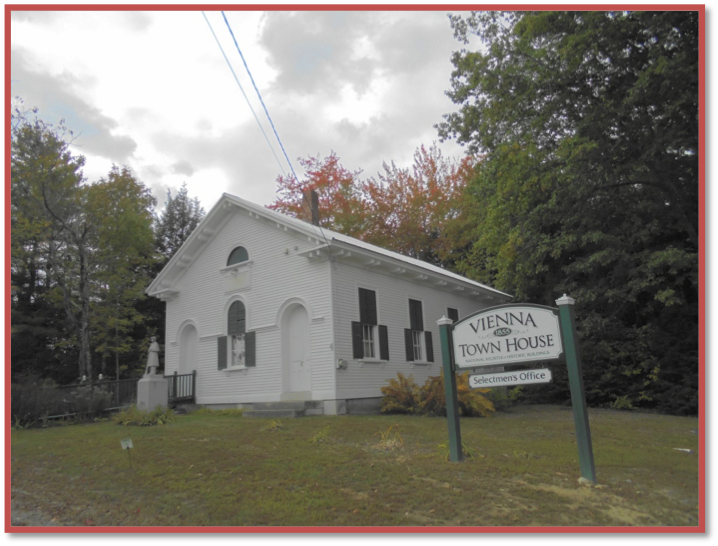
Fig.3. Town House, Vienna, Maine.
Photo by author

During the first decades of New England settlement town and religious meeting were often held in the same building, the meeting house. In the early stages of a town’s planting both kinds of gatherings were sometimes held in private homes or barns. With the passage of time and the growing demands of both church and town a separate structure, a town house, would be constructed to provide a place for town meetings and storage of government records. The raising of money to construct a town house represented a significant step in a town’s progress. Sometimes a wealthy citizen would donate funds for building the town house. This occurred in Vienna, Maine in 1854-55 when Joseph Whitter, a successful Boston merchant and child of Vienna, provided funds for a small Italianate style town house that continues to host town meeting (Fig.3). The structure is listed on the National Register of Historic Places (Vienna 2008). Vienna Town House is near the town’s geographic center on Town House Road and not at the village, ¾ of a mile to the southeast (fig.4).
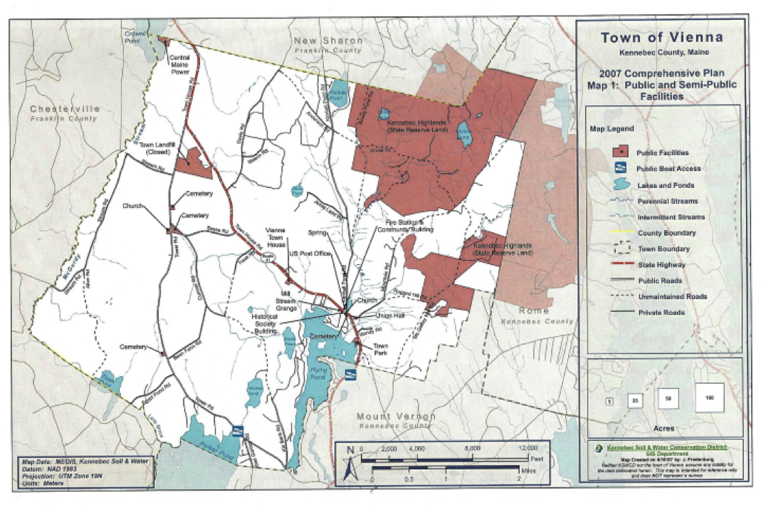
Fig.4. Vienna, Maine ( pop.570). Town House is near geographic center of town, ¾ mile northwest of village where most community services are located.
Source: Vienna (Maine) Comprehensive Plan Committee. 2008. Town of Vienna Comprehensive Plan.
Vienna, ME: Plan Committee.

As the frontier swept west the New England town meeting was left behind. Settlers from the Mid-Atlantic and Southern regions defended strong county government and it prevailed as new land came under organizer local rule. Counties are weak in New England where most small towns and rural places are controlled by town administration. The one aspect of the New England town that did go west is the 36 square mile township that we recognize on land surveyed under the United States Northwest Ordinance of 1785.

This year’s AAG meeting in Boston is during traditional town meeting season. If you can find an open format one to attend consider making the effort. Small towns in Maine, New Hampshire and Vermont are the best bet. Its real democracy in action and it will demonstrate to all that a New England town is not a village.


Paul B. Frederic is Professor of Geography Emeritus at University of Maine-Farmington and past Director of the Maine Land Use Regulation Commission. Email: frederic [at] myfairpoint [dot] net. He is in his eleventh year as a selectman in the Town of Starks, Maine. His research is on rural issues.

DOI: 10.14433/2016.0021

References

Barry, J. 2012. Roger Williams and the Creation of the American Soul. New York: Viking Press.

Bryan F. W. 2004. Real Democracy: The New England Town Meeting. Chicago: University of Chicago Press.

Guptill A. 1946. Norman Rockwell: Illustrator. New York: Watson Guptill Publishers.

Hawthorne, N. 1850. The Scarlet Letter. Boston: Ticker and Fields.

Murphy, R. E. 1964. “Town Structure and Urban Concepts in New England” The Professional Geographer, Vol.16 (1): 1-6. DOI: 10.1111/j.0033-0124.1964.001

Rutman, D.B. 1965. Winthrop’s Boston: A Portrait of a Puritan Town, 1630-1649. Chapel Hill: University of North Carolina Press.

Vienna (Maine) Comprehensive Plan Committee. 2008. Town of Vienna Comprehensive Plan.Vienna, ME: Plan Committee.

Wood, J.S. 1997. The New England Village. Baltimore: Johns Hopkins University Press.

Zimmerman, J. F. 1999. The New England Town Meeting. Westport, CT: Praeger Press.

    Share

A Museum of Geography, What?

Los Angeles’s Hollywood Bowl Overlook (Beau Rogers via Compfight)

On October 21, 2016, the Los Angeles Museum of Geography opened its first exhibition, “The Homeless Amongst Us,” in its temporary home at 2426 SET in the West Adams district of L.A. The exhibit, designed by John May and Zeina Koreitem of Millions Architecture, consists of three videotaped interviews with formerly homeless people projected onto the sides of levitating tents and a slide show of photographs of a homeless encampment, all of it undergirded by a haunting synthesizer score composed by former Mothers of Invention keyboard player, Don Preston. The exhibition intends to provoke discussion and incite thought about the condition of the homeless in this city.

That’s all very fine and good, and perhaps even noble and praiseworthy, but what is this about a museum of geography? Who ever heard of such a thing? What could it consist of? What possible void does it fill?

First, as we all know, there is no geography without history and no history without geography. This means that every museum of history that has ever graced the Earth, from the most venerable to the most humble, is also a geography museum. Otherwise, none of that history would have a place to take place in. So, by the route of default, there have been scores of geography museums without the benefit of naming rights. Next, as geography, in its broadest sense, is the study of that which is on the Earth, there is certainly plenty of allowance for bestowing upon the discipline the privilege of having its own museums. Certainly the possible subject matters are exceedingly ample, from the changing demographics of the urban mileau to the current state of global warming to economic change in Southeast Asia to the inevitable environmental and economic degradations of neoliberalism.

In Los Angeles, there are two specific reasons for opening a museum of geography. First, there is no history museum here. Though the snide may claim that’s because there is no history in the City of the Angels, I would suggest they dig a little deeper into the archive and study the record. Though this is a relatively young city, its history is rich and deeply textured. The very layout of the city reflects this, with the downtown core based on the Plan of the Indies, imposed by the Spanish during their rule, and the remainder of the city based on the Jeffersonian grid, imposed after the “Americans” took power. Still, despite this, there is no history museum, which leaves a yawning gap in the cultural landscape of the city, as most cities and many towns do have historical museums. So there is a void here that needs to be filled.

Secondly, Los Angeles, being a center of innovation and a hub of all that is new, novel, and even kooky, is the perfect city in the world to have its own geography museum. L.A. has been the birthplace, among others, of the Self Realization Fellowship and the Ham and Eggs movement, as well as the more infamous Church of Scientology and the International Church of the FourSquare Gospel, so why not a museum of geography? We also have a museum dedicated to Jurassic technology and a Death Museum, as well as the more famous but just as singular CityWalk and Knott’s Berry Farm: the region being a site of many wonders, one more wonder won’t seem all that weird.

Yet the Los Angeles Museum of Geography isn’t dedicated to the furtherance of kookiness. Its ambit is large, its range vast, its intentions serious. Though we debuted with an exhibit on the homeless and have another coming up on gentrification, certainly a pressing topic in this city, we are not confining ourselves to issue-oriented exhibitions. Our next show, for instance, will focus on everyday Los Angeles and will consist of a collection of ephemera reflecting the quotidian reality of the city. Bus passes and grocery store receipts will be featured as well as a selection of paintings and photographs reflecting the everyday nature of L.A. In the future, we will mount exhibitions detailing the various diasporas of ethnic groups and races who ended up planting their roots in Los Angeles, from Koreans to Mexicans to African-Americans to Iranians to Thais to Armenians. L.A. is a polyglot city, with more than 125 languages spoken by the students of Hollywood High School and a stunning array of ethnic and racial enclaves including a Thai Town, a Little Tokyo, a Koreatown, a Little Cambodia, a Chinatown, a Little Armenia, a Tehranangeles, a Little Bangladesh, a Little Ethiopia, and a Historic Filipinotown, not to mention the Crenshaw District, one of the largest African-American urban neighborhoods in the United States, and East L.A. and Boyle Heights, two of the largest concentrations of Mexican-Americans in the country. A series of exhibits will highlight these and other populations who have settled here.

However, we won’t ignore physical geography. The museum will host a show on earthquakes, certainly a topical subject in Los Angeles, and another on the subject of water in Los Angeles, an issue fraught with drama in this region, as anyone who has ever seen the film Chinatown will testify to. We will also focus on the economic geography of the region, with exhibitions on the motion picture business (AKA The Industry) and another on the former glory days of L.A.’s industrial past, when steel plants and car factories dotted the landscape of Southeast Los Angeles.

The museum also hopes to be an educational resource center for the community, offering free cultural geography and GIS courses to underserved K-12 students. It will also host conferences, colloquiums, and lectures about the geo-history of the region, and will present a series of films which use L.A. as its setting, from noir classic Double Indemnity to Oscar-winner Crash to academic favorite Blade Runner to the drama-documentary Exiles to cult film The Big Lebowski. A literary series featuring Los Angeles fiction will also be mounted, including tributes to If He Hollers Let Him Go by Chester Himes, Play It As It Lays by Joan Didion, and Inherent Vice by Thomas Pynchon, among others.

There is no reason why geography cannot take a central position in the cultural ambience of any big city. Pressing social issues are in our ambit, from the aforementioned homelessness and gentrification to economic dislocation and demographic transformations. There are anthropological museums, archeological museums, and of course history museums, not to mention sports museums, musical instrument museums and farm implement museums; I see no reason why there shouldn’t be geographical museums.

However, there is one obstacle and it may be an overwhelming one. It requires that geographers leave the academic grove, at least on a part-time basis, and engage with the wider community. This not only requires considerable time, often without immediate remuneration, but may also require a more generalized approach to the discipline, one that allows folks other than academics into the fold. A style is needed that is suited to a broad swath of the public, one that doesn’t dumb down complex ideas yet is accessible to all and sundry, from garage mechanics to nuclear physicists. A capacity to navigate through institutional terrain while simultaneously performing banal tasks, such as raising money and keeping to a budget, are also required. Many academics will throw up their hands at such a prospect: isn’t there enough bureaucratic balderdash in a typical geography department without ranging into the civic mileau and opening a damn museum?

That is a sentiment I readily understand, as I am facing many of these tedious mundane tasks as I launch the Los Angeles Museum of Geography. However, the opportunity of placing geography where it belongs – right in the center of things, in my estimation – is too tempting to bypass. So the next time you’re in L.A., look us up. Perhaps we’ll be exhibiting our upcoming show on the haunted geographies of L.A. or one on civic unrest in the city, certainly a subject writhing with promise, or the show on food in L.A. A geography museum does make sense as it can provide a wonderful avenue for geographers to present their ideas and research to an audience. May there be a thousand such museums in a thousand cities, from London to Dakar and Shanghai to Bogotá.

DOI: 10.14433/2016.0019

    Share

New Books: November 2016

Every month the AAG compiles a list of newly-published books in geography and related areas. Some are selected for review in the AAG Review of Books.

Publishers are welcome to send new volumes to the Editor-in-Chief (Kent Mathewson, Editor-in-Chief, AAG Review of Books, Department of Geography and Anthropology, Louisiana State University, Baton Rouge, LA 70803).

Anyone interested in reviewing these or other titles should also contact the Editor-in-Chief.

November 2016

Africa’s First Democrats: Somalia’s Aden A. Osman and Abdirqazak H. Hussen by Abdi Ismail Samatar (Indiana University Press 2016)

Ancient Plants and People: Contemporary Trends in Arcaeobotany by Marco Madella, Carla Lancelotti, and Manon Savard (University of Arizona Press 2014)

Anthropologies of Guayana: Cultural Spaces in Northeastern Amazonia by Neil L. Whitehead and Stephanie Alleman (eds.) (University of Arizona Press 2016)

Cannabis: Evolution & Ethnobotany by Robert C. Clark and Mark D. Merlin (University of California Press 2016)

Canoes: A Natural History in North America by Mark Neuzil & Norman Sims (University of Minnesota Press 2016)

Duress: Imperial Durabilities in our Times by Ann Laura Stoler (Duke University Press 2016)

Easy On, Easy Off: The Urban Pathology of America’s Small Towns by Jack Williams (University of Virginia Press 2016)

Eating The Ocean by Elspeth Probyn (Duke University Press 2016)

Encyclopedia of Geoarchaeology by Allan S. Gilbert, Paul Goldberg, Vance T. Holliday, Rolfe D. Mandel, and Robert S. Sternberg (eds.) (Springer 2017)

Food and Power in Hawai’i: Visions of Food Democracy by Aya Hirata Kimura and Krisnawati Suryanata (eds.) (University of Hawai’i Press 2016)

Framing Immigrants: News Coverage, Public Opinion, and Policy by Chris Haynes, Jennifer Merolla, and S. Karthick Ramakrishnan (Russell Sage Foundation 2016)

Indigenous Homelessness: Perspectives from Canada, Australia, and New Zealand by Evelyn J. Peters and Julia Christensen (eds.) (University of Manitoba Press 2016)

Interpreting Our World: 100 Discoveries that Revolutionized Geography by Joseph J. Kerski (ABC-CLIO 2016)

Land and Sea: A World-Historical Meditation by Carl Schmitt, Samuel Garrett Zeitlin (translator), and Russell A. Berman (ed.) (Telos Press 2017)

Losing Eden: An Environmental History of the American West by Sara Dant (Wiley-Blackwell 2016)

Map Use: Reading, Analysis, Interpretation, Eighth Edition by A. Jon Kimberling, Aileen R. Buckley, Phillip C. Muehrcke, and Juliana O. Muehrcke (ESRI Press 2016)

The Master Plant: Tobacco in Lowland South America by Andrew Russell and Elizabeth Rahman (eds.) (Bloomsbury 2016)

Medieval Islamic Maps: An Exploration by Karen C. Pinto (University of Chicago Press 2016)

Moral Ecology of a Forest: The Nature Industry and Maya Post-Conservation by José E. Martínez-Reyes (University of Arizona Press 2016)

Mountain: Nature and Culture by Veronica della Dora (University of Chicago Press 2016)

Nature & History in the Potomac Country: From Hunter-Gatherers to the Age of Jefferson by James D. Rice (Johns Hopkins University Press 2009)

New Lives for Ancient and Extinct Crops by Paul E. Minnis (University of Arizona Press 2014)

Oil and Nation: A History of Bolivia’s Petroleum Sector by Stephen C. Cote (West Virginia University Press 2016)

Peanuts and Philosophy: You’re a Wise Man, Charlie Brown! by Richard Greene and Rachel Robison-Greene (eds.) (Open Court Publishing Company 2017)

People Cities: The Life and Legacy of Jan Gehl by Annie Matat and Peter Newman (Island Press 2016)

Sea Level Rise in Florida: Science, Impacts, and Options by Albert C. Hine, Don P. Chambers, Tonya D. Clayton, Mark R. Hafen, and Gary T. Mitchum (University Press of Florida 2016)

Supplanting America Railroads: The Early Auto Age by John A. Jakle and Keith A. Sculle (University of Tennessee Press 2016)

Towards a Cultural Politics of Climate Change: Devices, Desires, and Dissent by Harriet Bulkeley, Matthew Paterson, and Johannes Stripple (eds.) (Cambridge University Press 2016)

Treasures from the Map Room by Debbie Hall (University of Chicago Press 2016)

Unprecedented Climate Mobilization: A Handbook for Citizens and their Governments by Elizabeth Woodward and David Ray Griffin (Clarity Press 2016)

Vanishing America: Species Extinction, Racial Peril, and the Origin of Conservation by Miles A. Powell (Harvard University Press 2016)

Waves of Knowing: A Seascape Epistemology by Karin Amimoto Ingersoll (Duke University Press 2016)

    Share

AAG Unveils New Disciplinary Data Dashboard

The AAG receives numerous requests for data related to geography and geographers. Often such requests come from members who are doing research on the discipline, or who are interested in knowing, for example, the proportion of women who hold the rank of associate professor or the average value of a graduate student assistantship.

Academic departments also frequently contact the AAG seeking data that will inform a program review, support an application to establish a new degree program, or help them make a case to prospective majors interested in career opportunities in geography. It is also common for the AAG to receive inquiries from journalists and the general public about the status of geographic literacy in K-12 schools or enrollment trends in higher education.

The AAG has been able to respond to these many requests for data thanks to its multiple ongoing data collection efforts involving members, departments, and special research surveys. Over the past decade this work has generated a considerable amount of data and content across the entire AAG website.

In an effort to consolidate and facilitate access to all of the disciplinary data collected by the AAG, a new AAG Disciplinary Data Dashboard was created on the AAG website at www.aag.org/disciplinarydata.

The Dashboard provides access to a diverse array of AAG-collected disciplinary data on gender and diversity, academic departments, geography careers, and AAG Annual Meetings, as well as archival information and materials available in the AAG Archives held at the Library of Congress. All of the data is searchable by source or by theme (e.g., geography in schools, gender, race and ethnicity, etc.).

In addition to raw data collected from AAG membership forms, academic department surveys, and other AAG research projects, the Dashboard includes original analytical reports featuring narrative summaries and data visualizations that provide quick overviews of major trends and patterns. Additional reports are currently being prepared by AAG staff and will be posted to the Dashboard in the coming months.

Visitors to the Dashboard will also find links to many third-party sources of disciplinary data produced by external organizations, as well as updated lists of journal articles and other research publications about geography as a discipline.

The AAG invites all members to explore the AAG Disciplinary Data Dashboard. We welcome your comments and suggestions at data [at] aag [dot] org.

    Share

Act Now to Support the AAG’s AP GIS&T Proposal

The AAG’s proposal for a new Advanced Placement course in Geographic Information Science and Technology (AP GIS&T) continues to receive strong interest from high schools, colleges, and universities across the U.S.

To complete the proposal package for the College Board, the AAG needs to collect attestations of interest from at least 100 postsecondary institutions and 250 high schools. AAG members can lend their support to this effort in two important ways.

First, department chairs can add their program to the list of AP GIS&T supporters by completing an attestation at www.apgist.org.

As of November 1, AAG has received signed attestations from 93 departments, a number that includes dozens of major research universities and members of the University Consortium for Geographic Information Science. The attestation process provides evidence that the academic community views the proposed AP course to be equivalent to college-level instruction and that departments will consider offering credit to students who demonstrate proficiency on the AP exam.

The AAG especially needs additional attestations from undergraduate geography and GIS programs affiliated with institutions that rank among the College Board’s list of Top 200 AP-score receiving colleges and universities. Department chairs from these institutions are encouraged to express their interest in AP GIS&T by submitting an attestation for their program.

Second, the AAG invites all members to share the AP GIS&T proposal with high schools in their local community. So far 86 high schools have registered their interest in the AP GIS&T course.

With Geography Awareness Week and GIS Day celebrations just two weeks away, now is a great time to reach out to high schools and encourage them to register their interest in AP GIS&T. Schools that currently teach AP Human Geography, participate in the ConnectED program, or offer other GIS coursework are especially likely to benefit from the synergies created by the AP GIS&T course. AAG members are welcome to email or print this flyer summarizing the content and benefits of AP GIS&T for high schools.

Questions about the AP GIS&T proposal and attestation process may be sent to Dr. Michael Solem, AAG Deputy Director for Research and Education, at msolem [at] aag [dot] org.

    Share

David Slater

David Slater, Emeritus Professor of Political Geography at Loughborough University, UK, who was a leading critical development geographer and known for his work on Latin America, passed away on October 20, 2016.

Slater studied for a bachelor’s degree in geography at Durham University in the mid-1960s which was when he first became interested in geopolitics, seeking to understand international relations in a spatial context. He went on to the London School of Economics, where he completed a doctorate in geography in 1972.

His long career saw him teach at universities in Africa, Asia, Latin America, North American and Europe. He was based at CEDLA (the Interuniversity Centre for Latin American Research and Documentation) in The Netherlands for a number of years before moving to the Department of Geography at Loughborough University as Professor of Political Geography from 1994 to 2011. During that time he also served as the editor of Political Geography (1999-2004). In 2011 he became Emeritus Professor at Loughborough University and was also an Associate Fellow at the Institute for the Study of the Americas, University of London.

During the 1970s Slater emerged as a distinctive voice in radical development geography, critiquing mainstream development concepts, models and theories. He used a Marxist framework to explain the spatial characteristics of development, specifically how underdevelopment in the ‘Third World’ was shaped and perpetuated by relationships with the West. His pair of papers published in Antipode on “Geography and Underdevelopment” (1973 and 1977) were particularly influential and remain widely cited to this day. He wrote them while working in Tanzania at the University of Dar Es Salaam, during which time he was inspired by scholars from Africa, Asia and Latin America who were explaining inequality and underdevelopment in terms of colonial exploitation, political domination and dependency.

During the 1980s, Slater focused much of his attention on Latin America. Among his significant publications during that period was the book Territory and State Power in Latin America: The Peruvian Case (Palgrave Macmillan 1989) which examined the central spatial tendencies of capitalist development and state-society relations in Peru between 1914 and 1984, but with wider applicability to other countries in the region. He also edited Social Movements and Political Change in Latin America (CEDLA 1985), a compilation of papers from a CEDLA workshop held in 1983 on the topic of new social movements and the state in Latin America.

It is difficult to select examples from someone who had such a prolific writing output and published consistently in leading journals of geography, development studies, and political science. Certainly worthy of mention and exemplifying one of the major themes in his work is the article “On the borders of social theory: learning from other regions” (Environment and Planning D 1992) which was a criticism of Western ethnocentrism. He argued that ‘First World’ geographers should examine the West’s relationship with the ‘Third World’ in order to appreciate their own societies. His argument about ‘learning from other regions’ was quite influential as human geography began to grapple with  postcolonial thought and remains very relevant today.

A number of Slater’s publications examined US power. The American Century: Consensus and Coercion in the Projection of American Power (Wiley-Blackwell 1999), jointly edited with Loughborough University colleague Peter Taylor, brought together studies of Americanization and American imperialism to assess how far the twentieth century can be seen as the ‘American Century.’ Following this, his much lauded book, entitled Geopolitics and the Post-Colonial: Rethinking North-South Relations (Wiley-Blackwell 2004), focused onUS-Latin American encounters and theorized an alternative postcolonial perspective for understanding contemporary political and economic globalization.

Over many decades, Slater’s work consistently challenged Western hegemony. His critical analyses of North-South relations exposed long-standing, ongoing and acute asymmetries of power and geopolitical injustice. While he was a provocative voice, he was also very highly regarded as a scholar. His complex theoretical work was deftly written and grounded in real examples. He was an inspiration to many students who were drawn to his critical perspectives on development studies and political geography. He will be fondly remembered by many colleagues at Loughborough University and beyond.

    Share

New Books: October 2016

Every month the AAG compiles a list of newly-published books in geography and related areas. Some are selected for review in the AAG Review of Books.

Publishers are welcome to send new volumes to the Editor-in-Chief (Kent Mathewson, Editor-in-Chief, AAG Review of Books, Department of Geography and Anthropology, Louisiana State University, Baton Rouge, LA 70803).

Anyone interested in reviewing these or other titles should also contact the Editor-in-Chief.

November 2016

Africa’s First Democrats: Somalia’s Aden A. Osman and Abdirqazak H. Hussen by Abdi Ismail Samatar (Indiana University Press 2016)

Ancient Plants and People: Contemporary Trends in Arcaeobotany by Marco Madella, Carla Lancelotti, and Manon Savard (University of Arizona Press 2014)

Anthropologies of Guayana: Cultural Spaces in Northeastern Amazonia by Neil L. Whitehead and Stephanie Alleman (eds.) (University of Arizona Press 2016)

Cannabis: Evolution & Ethnobotany by Robert C. Clark and Mark D. Merlin (University of California Press 2016)

Canoes: A Natural History in North America by Mark Neuzil & Norman Sims (University of Minnesota Press 2016)

Duress: Imperial Durabilities in our Times by Ann Laura Stoler (Duke University Press 2016)

Easy On, Easy Off: The Urban Pathology of America’s Small Towns by Jack Williams (University of Virginia Press 2016)

Eating The Ocean by Elspeth Probyn (Duke University Press 2016)

Encyclopedia of Geoarchaeology by Allan S. Gilbert, Paul Goldberg, Vance T. Holliday, Rolfe D. Mandel, and Robert S. Sternberg (eds.) (Springer 2017)

Food and Power in Hawai’i: Visions of Food Democracy by Aya Hirata Kimura and Krisnawati Suryanata (eds.) (University of Hawai’i Press 2016)

Framing Immigrants: News Coverage, Public Opinion, and Policy by Chris Haynes, Jennifer Merolla, and S. Karthick Ramakrishnan (Russell Sage Foundation 2016)

Indigenous Homelessness: Perspectives from Canada, Australia, and New Zealand by Evelyn J. Peters and Julia Christensen (eds.) (University of Manitoba Press 2016)

Interpreting Our World: 100 Discoveries that Revolutionized Geography by Joseph J. Kerski (ABC-CLIO 2016)

Land and Sea: A World-Historical Meditation by Carl Schmitt, Samuel Garrett Zeitlin (translator), and Russell A. Berman (ed.) (Telos Press 2017)

Losing Eden: An Environmental History of the American West by Sara Dant (Wiley-Blackwell 2016)

Map Use: Reading, Analysis, Interpretation, Eighth Edition by A. Jon Kimberling, Aileen R. Buckley, Phillip C. Muehrcke, and Juliana O. Muehrcke (ESRI Press 2016)

The Master Plant: Tobacco in Lowland South America by Andrew Russell and Elizabeth Rahman (eds.) (Bloomsbury 2016)

Medieval Islamic Maps: An Exploration by Karen C. Pinto (University of Chicago Press 2016)

Moral Ecology of a Forest: The Nature Industry and Maya Post-Conservation by José E. Martínez-Reyes (University of Arizona Press 2016)

Mountain: Nature and Culture by Veronica della Dora (University of Chicago Press 2016)

Nature & History in the Potomac Country: From Hunter-Gatherers to the Age of Jefferson by James D. Rice (Johns Hopkins University Press 2009)

New Lives for Ancient and Extinct Crops by Paul E. Minnis (University of Arizona Press 2014)

Oil and Nation: A History of Bolivia’s Petroleum Sector by Stephen C. Cote (West Virginia University Press 2016)

Peanuts and Philosophy: You’re a Wise Man, Charlie Brown! by Richard Greene and Rachel Robison-Greene (eds.) (Open Court Publishing Company 2017)

People Cities: The Life and Legacy of Jan Gehl by Annie Matat and Peter Newman (Island Press 2016)

Sea Level Rise in Florida: Science, Impacts, and Options by Albert C. Hine, Don P. Chambers, Tonya D. Clayton, Mark R. Hafen, and Gary T. Mitchum (University Press of Florida 2016)

Supplanting America Railroads: The Early Auto Age by John A. Jakle and Keith A. Sculle (University of Tennessee Press 2016)

Towards a Cultural Politics of Climate Change: Devices, Desires, and Dissent by Harriet Bulkeley, Matthew Paterson, and Johannes Stripple (eds.) (Cambridge University Press 2016)

Treasures from the Map Room by Debbie Hall (University of Chicago Press 2016)

Unprecedented Climate Mobilization: A Handbook for Citizens and their Governments by Elizabeth Woodward and David Ray Griffin (Clarity Press 2016)

Vanishing America: Species Extinction, Racial Peril, and the Origin of Conservation by Miles A. Powell (Harvard University Press 2016)

Waves of Knowing: A Seascape Epistemology by Karin Amimoto Ingersoll (Duke University Press 2016)

    Share

Lawrence S. Hamilton

Larry Hamilton, emeritus professor of natural resources at Cornell University, who played a leading role in the worldwide conservation of mountain areas, passed away on October 6, 2016, at the age of 91.

Lawrence Stanley Hamilton was born in Toronto in 1925. He couldn’t wait to get out of the city and started working in logging camps in the North Woods during the summers while he was still a teenager. During the Second World War he served in the Royal Navy Fleet Air Arm as a pilot. Both his early connection to forests and his exposure to the horrors of war went on to shape the rest of his life.

After the war Hamilton enrolled at the University of Toronto to study forestry while also working as Zone Forester in Ontario. For postgraduate studies he moved to the College of Forestry at Syracuse University, completing his master’s degree in 1950 with a dissertation entitled “An economic analysis of the cutting of sugar maple (Acer saccharum Marsh.) in small woodlots in the vicinity of Syracuse.” This was followed by a doctorate in natural resource policy at the University of Michigan; his dissertation, completed in 1962, was entitled “An analysis of New York State’s Forest Practice Act.”

Hamilton joined the Department of Natural Resources at Cornell University in 1951 and stayed there for 30 years before becoming professor emeritus. He was an exceptional educator, advisor, and pioneer of courses in forest ecology, watershed studies, interdisciplinary collaboration, and international resource issues. In the early 1970s, he produced one of the first documentations of tropical rainforest deforestation (Venezuela) and mangrove destruction (Trinidad).

In 1980 he moved to Hawaii and spent the next 13 years as a Senior Fellow in the Environment and Policy Institute at the East-West Center, an institution which aims to promote technological and cultural interchange between people in the United States, Asia and the Pacific region. He traveled all over the region including Thailand, Western Samoa, Nepal, Indonesia, and Australia doing pioneering education in forest hydrology and tropical forestry, convening workshops and authoring hundreds of applied conservation publications.

While in Asia Hamilton became interested in mountains, recognizing them as unique and very delicate ecosystems, and suggesting that conservation efforts that work in many other environments can be devastating for mountains.

Since the 1970s he had been a member of the International Union for the Conservation of Nature’s (IUCN) Commission on National Parks and Protected Areas (subsequently known as the World Commission on Protected Areas (WCPA)), but it was during the 1980s that he began to draw the Commission’s attention to mountains.

Hamilton and a small group of fellow scientists launched a concerted call for mountain conservation, publishing “The State of the World’s Mountains: A Global Report.” They took their message to a wider audience as “An Appeal for the Mountains,” which was presented to the 1992 United Nations Conference on Environment and Development (Rio Earth Summit) and became the basis for the mountain chapter in Agenda 21. This effort, and the ensuing awareness of mountain ecology, is the work of which Hamilton said he was most proud.

Over the next 25 years, under his leadership, the mountain theme became an important element of the WCPA’s work and he built a strong global network of mountain enthusiasts and experts. He brought them together in numerous WCPA mountain workshops including Hawaii (1991), Australia (1995), Canada (1996) and South Africa (2003).

On the ground he provided guidance and advice to mountain protected areas including parks and reserves in Australia, Bhutan, Canada, Ecuador, USA and Nepal. He championed tropical montane cloud forests, corridors of ecological connectivity, trans-border cooperation for conservation and peace, understanding of mountains as water towers, and the spiritual/cultural values of mountains.

His formidable paper legacy is to be found in almost 400 publications including: IUCN guidelines on Transboundary Protected Areas for Peace and Co-operation (2001) and Planning and Managing Mountain Protected Areas (2004); and Managing Mountain Protected Areas: Challenges and Responses for the 21st Century (2004). He made special mountain contributions to PARKS (1996), the IUCN Bulletin (2002), and a World Heritage publication (2002). From 1992 until 2015, he also edited 89 editions of the quarterly newsletter Mountain Protected Areas Update.

For his work Hamilton received the New York State Conservation Council’s Forest Conservationist of the Year award (1969); the Environmental Achiever Award from the UN Environment Program (1987); the IUCN/WCPA Packard International Parks Merit Award (2003); Hawai’i University’s Distinguished Scientist award for work on Cloud Forest Conservation (2004); the Gold Medal for Mountain Conservation Leadership from the King Albert I Memorial Foundation in Switzerland (2004); and Honorary IUCN Membership (2008).

In 1993 Hamilton and his wife moved to Vermont to be near family. They set up home in the small rural community of Charlotte where they loved the natural surroundings and the four seasons. They also liked the sense of neighborliness and civic participation, and Hamilton was proud to be a local tree warden. He also served for over two decades as a trustee of The Nature Conservancy (TNC) Vermont where he shared his expertise through many local conservation initiatives. Just two days before his death, he was delighted to learn that they named the trail in the local TNC forest preserve the “Hamilton Trail.”

As well as the local engagement, bigger conservation issues continued to concern him. For example, in 2011 he travelled to Washington, DC to protest at the White House against the Tar Sands Pipeline Initiative. Beyond his conservation activism, he was also a pacifist and was an active member of Veterans for Peace.

Lawrence Hamilton’s life was grounded in a love of nature. He said, “If I can be responsible for saving one little chunk, I will have had a successful life.” In reality, his life’s work ensured the protection of mountain areas passing through whole continents, and their preservation as biological and cultural treasures for our future generations. He will be remembered for his vision, commitment, enthusiasm and youthful energy. Although not a geographer per se, his academic work and practical action was an inspiration to many, including members of the AAG’s Mountain Geography Specialty Group.

Larry is survived by his wife of 36 years, Linda; children Bruce, Anne and Lynne; as well as seven grandchildren and one great-grandchild.

Main sources:
New York Times obituary, October 2016
Obituary on IUCN website, October 2016
Blog by Gillian Randall, November 2011

    Share

Ary J. Lamme III

Ary Lamme, a cultural and historical geographer and professor emeritus at the University of Florida, passed away in September 2016 at the age of 76.

Ary Johannes Lamme III was born in New York on June 30, 1940. His grandfather, Ary Johannes Lamme Sr. had emigrated from Holland in the late nineteenth century and settled in New York.

By the time he was a small boy, the family had moved to Westminster in western Maryland, although his father still worked in New York and commuted home at weekends. From there the family had regular outings to the battlefields at Gettysburg and Lamme remembered enjoying the countryside, the war stories, and having picnics together. This was perhaps the gestation of a lifelong interest in historic landscapes, and Gettysburg would be a central example in one of his major works later in his professional life.

At McDonogh School on the outskirts of Baltimore, Maryland, Lamme enjoyed mathematics and the social sciences. He then went on to Principia College, Illinois, for undergraduate studies, graduating in 1962. He later acknowledged the role of particular geography, history and English professors there who enabled him to develop and use important scholarly tools.

Next Lamme moved to the University of Illinois for a master’s degree in geography, graduating in 1965. Military service then intervened and he served as an instructor squadron commander in the U.S. Air Force in Vietnam.

After an unexpected release from the military, one of his former professors from Illinois enabled him to enter Syracuse University for a doctorate. There he was particularly influenced by David Sopher and Donald Meinig and their work on historic and cultural landscapes. His dissertation, completed in 1968, was entitled “The Spatial and Ecological Characteristics of the Diffusion of Christian Science in the United States: 1875-1910.”

His first teaching position was at the State University of New York at Cortland before moving to the University of Florida at Gainesville in the early 1970s, where he stayed for over three decades.

Lamme was interested in different aspects of cultural and historical geography, as reflected in his publications which cover topics including the historical development and spatial distribution of religious groups, the cultural landscape of the Amish homelands, the sense of vernacular regional identity in Florida, and a comparison of the physical characteristics of spaces where people were enslaved and where they were freed.

One of his most noted publications was the book “America’s Historic Landscapes: Community Power and the Preservation of Four National Historic Sites” (1990) which explored historic landscapes and how they acquire meaning. He used four case studies – St Augustine in Florida, Colonial National Historical Park in Virginia, Sackets Harbor in New York, and Gettysburg in Pennsylvania – to explore the community power issues involved in landscape preservation.

Lamme was a long-time member of the American Association of Geographers and recognized for 50 years of continuous membership in 2014. He was also involved in the Southeast Division (SEDAAG) and had presented his work at the Race, Ethnicity and Place Conference.

Ary Lamme will be remembered fondly by many former colleagues. He leaves behind his wife, Sandra, and two adult children, Laurel and Ary Johannes IV.

    Share

Sally E. Eden

Sally Eden, professor of Human Geography at the University of Hull, UK, whose research explored issues of environmental perception, sustainable food production and consumption, passed away peacefully in September 2016 after a period of illness.

Sally E. Eden was born in 1967. She studied for a bachelor’s degree at the University of Durham followed by a doctorate at the University of Leeds.

Her first academic posts were at the University of Bristol and Middlesex University where she taught geography and environmental studies before joining the Department of Geography at the University of Hull in 1998 where she served for the last 18 years.

Eden’s research explored how people relate to the environment through consumption, leisure, knowledge and policy.

One strand of work investigated how nongovernmental organizations use and communicate environmental information, and how environmental science is used to influence policy and consumption. For this she focused on water environments, researching how river restoration is designed and justified and how laypeople get involved with and make sense of river management in the UK.

Another area of research was how ideas of sustainable consumption, environmentally friendly products and green lifestyles are constructed, legitimated, sold, understood and put into practice (or not). She explored these issues through case studies such as the environmental certification of organic food, sustainably farmed fish and well managed forests.

From 2013-15 she was Co-Investigator on a major project funded jointly by the UK Research Councils called Digital Economy: Food Trust. The goal was to explore how digital tools can promote more sustainable production and consumption of food through connecting producers and consumers. It involved the creation of three prototype apps – ‘Food Cloud’, ‘FoodCrowd’ and ‘Shopstamp.’ One of these, for example, enabled shoppers to scan QR codes on food products to access information about the farm where the item was produced.

Eden’s work was widely published in leading journals of geography, environment and rural studies. Sadly she passed away before publication of her book, Environmental Publics (Routledge, December 2016). This volume explores how ordinary people think about the environment as they go about their daily lives; how they engage with environmental issues in different contexts of work, leisure and home; and whether thinking about the environment make them do things differently.

Eden was a member of the AAG and a regular attendee at the Annual Meetings. She was also one of the Section Editors for the AAG’s The International Encyclopedia of Geography: People, the Earth, Environment, and Technology (Wiley, 2017). She was responsible for the “Environmental Policy, Management, and Governance” section, and also wrote three entries for the encyclopedia: Environmental Science, Environmental Restoration, and Environmental Issues and Public Understanding (the latter with Hilary Geoghegan). The AAG team will remember her as an excellent editor as well as a lovely person with whom to work. Her colleagues at the University of Hull and beyond will miss her greatly.

    Share