Every month the AAG compiles a list of newly-published books in geography and related areas. Some are selected for review in the AAG Review of Books.
Publishers are welcome to send new volumes to the Editor-in-Chief (Kent Mathewson, Editor-in-Chief, AAG Review of Books, Department of Geography and Anthropology, Louisiana State University, Baton Rouge, LA 70803).
Anyone interested in reviewing these or other titles should also contact the Editor-in-Chief.
AAG President Highlights Civil Rights at Ohio University Colloquium
On November 3, 2017 AAG President Derek Alderman addressed the Ohio University Geography Department through its Colloquium program. His talk, entitled “Civil Rights as Geospatial Work: Role of Counter Mapping and Radical Place-making in the African American Freedom Struggle”, engaged the audience in a critical look at how geographers can play a role in discussing and practicing civil rights. He emphasized that geographers now have an opportunity to be active in a second wave of Civil Rights movements, making specific note that there is a chance to feature not only civil rights struggles, but the ways in which we talk about them. Coinciding with the Geography Awareness Week theme of the geography of civil rights movements, Alderman highlighted how geographers can interact with new grassroots movements and ways of knowing about race and place.
A key moment of Alderman’s talk called attention to the next generation of geographers. “Students will be our planners and mappers for the future–but you won’t be doing that alone, you’ll do that as part of a larger history of [geospatial and civil rights] work,” Alderman remarked. The statement captures an idea at the heart of his presentation– civil rights and geography are fundamentally linked and have a deep history which can and should be explored further. Examples of the geospatial work Alderman discussed included The Green Book, a tool which helped black travelers during the height of segregation in America, and the importance of data during sit-ins and bus boycotts. One way of looking at these important topics is to view them as part of a longer, broader civil rights movement beyond the common narratives many of us are familiar with today.
The Ohio University Geography Colloquium is a four-part, semester-long series. Chosen by the OU faculty and a graduate student representative, the colloquium speakers connect students with a variety of areas of geographic research. Many Geography departments regularly host similar events with guest speakers sharing information on topics, study areas, or research initiatives they are passionate about and ways they filter into popular culture. For students, these events can help them explore new areas of geographic thought and inspire new research ideas. For faculty in attendance, it presents an opportunity to branch out into other geographic subfields and become energized for their own research.
One way that the AAG supports colloquium programs and the sharing of geographic ideas is through the Visiting Geographical Scientist Program (VGSP). Funded by the Gamma Theta Upsilon Geography Honor Society, the program is geared towards small departments with limited resources to bring in notable geographers as guest speakers. The VGSP helps to identify potential visitors and assists with costs for travel.
Additionally, the AAG has kicked off a brand new resource to highlight geographers interested in and available to give presentations on various aspects of geographic thought and research. The Geography Speakers Bureau is designed to facilitate connections between speakers and those hosting events such as department colloquia, or media contacts seeking a geographer perspective on a topic. The Speakers Bureau, still in development with more speakers to be added, highlights distinguished geographers and their research interests and encourages a culture of public speaking within the field. Not only does the Speakers Bureau aim to connect geographers to each other, but it also seeks to increase public engagement to help communicate all that geography has to offer the world.
Commemorating the Enslaved Along Louisiana’s River Road
Members of the NSF research team visit the River Road African American Museum in Donaldsonville, Louisiana in June of 2013. (Photo by Amy Potter)
Between New Orleans and Baton Rouge, lies the remnants of antebellum sugar plantations along Louisiana’s famed River Road, named for the Mississippi River that snakes its way through southern Louisiana before spilling into the Gulf of Mexico. Many of the eighteenth-century and nineteenth-century plantation homes that still exist along this road have been preserved, and some have been transformed into museums dedicated to retelling Louisiana’s antebellum period. A few of these museums attract as many as 200,000 visitors a year (Oak Alley and Laura, A Creole Plantation, for example). Most of these plantation house museums, however, have traditionally focused their narrative presentations on the planter and his family, which necessitates that tours be spatially arranged in and around the planter’s home (The Big House).
Such narratives have traditionally marginalized, segregated, or even omitted stories of the enslaved persons whose labors made these landscapes and vast fortunes possible (Eichstedt and Small 2002). Instead of focusing on the people who toiled and effectively created these landscapes, visitors to these sites are regaled with stories of romance, wealth, scandal, and entrepreneurship, and are enchanted by elaborately costumed guides and Oak tree-lined boulevards. Narratives and artifacts tend to limit visitors’ engagement with the enslaved to the hyperlocal and the safely distant past. While their traces are to be found throughout the house and across the landscape, the onus is on visitors to seek them out.
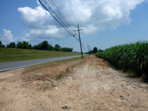
Louisiana’s Highway 18 near Whitney Plantation in summer of 2017. Mississippi River levee on the left and sugar cane on the right. (Photo by Amy Potter)
Disturbed by the absence of the enslaved from these museums’ tour narratives, a team of geographers (Derek H. Alderman, Candace Forbes Bright, David L. Butler, Perry L. Carter, Stephen P. Hanna, E. Arnold Modlin, and Amy E. Potter) received a three-year National Science Foundation grant in 2014 to research how plantations in the South present enslavement. The grant allowed the team to continue their work on plantations in the River Road region (Alderman, Butler, and Hanna 2016), as well as expand this work into Charleston, South Carolina and the James River region of Virginia in order to gain an understanding of regional variations among plantation museum landscapes and narratives. Over a decade of research by some members of our team (Butler 2001; Modlin 2011) allows us to reflect on the transformation of the River Road region alongside other plantations in the South as they struggle to engage with the legacy of slavery.
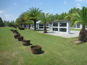
Allées Gwendolyn Midlo Hall, dedicated to the memory of enslaved persons in Louisiana. (Photo by Amy Potter)
The gross neglect of the stories of the enslaved within the region has been challenged through the development of counter narrative sites. One of these early sites in the region is the River Road African American Museum located today in Donaldsonville, Louisiana. The museum, opened in 1994, is the creation of Kathe Hambrick. Kathe, a native of Louisiana, returned from time away in California and toured plantation museums along the Mississippi River in the early nineties. She was concerned with the romanticizing of plantation life and found the narratives of the enslaved omitted from plantation museums’ presentations. Upon realizing this omission Kathe determined she wanted to do something to change that. The River Road African Museum site notes that “she vowed to her herself – We must do something to tell our story…’ Later on, one night, it just came to Hambrick that the answer was a museum.” (River Road African American Museum 2017)
More recently, the region has experienced another monumental shift in its interpretation of slavery with the 2014 opening of Whitney Plantation, financed by New Orleans attorney John Cummings. Whitney Plantation in many ways is the antithesis of the traditional plantation tourist experience. Rather than center a tour on the house and the planter family, Whitney foregrounds the voices of the enslaved. The tour is an inversion of the spatial narrative with much less emphasis on the Big House.
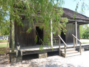
Children of Whitney located on a front porch of one of the original slave cabins on the property. (Photo by Amy Potter)
Our research team partnered with Whitney in the spring of 2015 as part of our larger project. Several of us have returned since its inaugural year to observe the changes taking place over the site.
In an effort to create a plantation tour that prioritizes the stories and voices of enslaved persons, Whitney utilizes resources like the Federal Writers’ Project of the Works Progress Administration Slave Narrative Collection (1936 to 1938). While the oral histories captured by the mostly white WPA interviewers are problematic (Carter, Butler, and Dwyer 2011), Whitney’s use of excerpts from these interviews with formerly enslaved persons, most of whom were children before emancipation, gives expression to those who help create this region and this country.
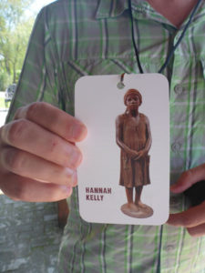
Visitors receive a lanyard connecting them to the story of a formerly enslaved child. (Photo by Amy Potter)
While most plantation tours begin by crediting white owners for “building” the house and grounds, Whitney turns the visitor’s attention to enslaved persons (particularly children) immediately upon entering the welcome center. Visitors receive a lanyard (to keep) featuring the words and image of a formerly enslaved child. One such example is Hannah Kelly, who was 10 years old when she was emancipated. While waiting for the 90-minute tour to start visitors can explore an exhibit on slavery, which situates the visitor within a multi-scale history that eventually connects to River Road.
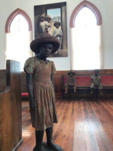
The Children of Whitney, a series of sculptures created by artist Woodrow Nash in the Antioch Church. (Photo by Amy Potter)
After an introduction, visitors begin their tour of the property – a tour laid out to first honor the enslaved, then to educate visitors about the everyday lives of slaves along the River Road, and, finally to connect Whitney to both the broader historical geography of slavery and the legacies of slavery haunting us today. Guides first invite visitors to enter Antioch Church where they encounter the Children of Whitney, a series of sculptures created by artist Woodrow Nash who was inspired by 19th century photographs of enslaved children. These same children appear on the lanyards visitors wear around their necks – an intentional effort by the museum to encourage visitors to connect emotionally with the enslaved.
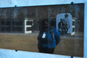
The tour continues to the Wall of Honor, where we learn about Anna, one of 354 enslaved persons connected to the property. Anna, we are told, was just four years old when she was bought on the dock of New Orleans in 1814 (her mother died on the journey from the Chesapeake). As she grew older she was raped by her mistress’s brother. She is the black matriarch of the eminent Haydel family of New Orleans (Sybil Morial, a descendant of Anna, is the wife of Ernest Morial, New Orleans’ first African-American mayor, and mother of Marc Morial, who also served as Mayor of New Orleans).
The Field of Angels is dedicated to the children who were enslaved in Louisiana and died before their third birthday. (Photo by Amy Potter)
Other stops along the tour include the Gwendolyn Hall Memorial and the Field of Angels, dedicated to the 2,200 children who were enslaved in Louisiana and died before their third birthday. The tour winds through the rows of slave cabins, two of which are original to the property, eventually making its way to the “Big House.” In contrast to most plantation tours, just a few minutes of the tour are spent inside the house and even here the narrative treats the house as a place of work for enslaved women and children. Visitors then return to the welcome center where they are asked to reflect on the tour and share their thoughts on a wall.
Contemplating the enslaved at Allées Gwendolyn Midlo Hall. (Photo by Raymond Glasgow)
Since the racially motivated mass shooting of worshippers at Mother Emanuel Church in Charleston, South Carolina and the violent gathering of neo-Nazis, KKK, and white supremacists in Charlottesville, Virginia, the foundations of white supremacist accounts of the antebellum South are shaken as never before. New Orleans led the way in pulling down monuments glorifying Confederate “heroes” and cities and towns throughout the country are grappling with the challenge commemorating slavery and the enslaved poses to our national mythos. Southern plantation museums like those on River Road, landscapes that traditionally reproduced a Gone with the Wind version of Southern domesticity, are in many ways at the heart of this struggle.
Carter, P. L., Butler, D. L, and Dwyer, O. (2011). Defetishizing the plantation: African Americans in the memorialized South. Historical Geography 39: 128-146.
Eichstedt, J., and Small, S. 2002. Representations of slavery: Race and ideology in southern plantation museums. Washington, DC: Smithsonian Institution Press.
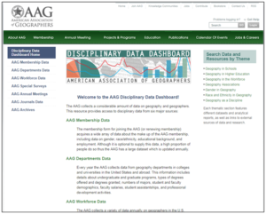
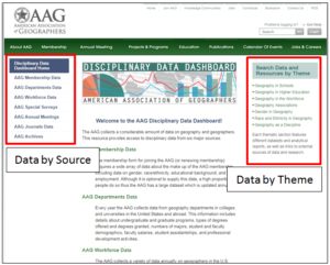
The Disciplinary Data Dashboard site on the AAG website.
Are you interested in trends in geography? Have you been looking for openly available datasets to investigate aspects of our discipline for a report or research project? We have the answers for you in our freely accessible data resource, the AAG Disciplinary Data Dashboard.
It is important for researchers, students, and other information-seekers to have a single place to go to and easily find consistently updated disciplinary facts and figures. To meet this need, the AAG has created the Disciplinary Data Dashboard as a central repository for visitors to easily and freely access and utilize data on geography as a field of study.
The AAG has always gathered and made available annual data in two key areas:
AAG Membership Data. Collected via membership forms which all AAG members have the option to complete when renewing membership or on the online member profile page.
Geography Department Data. Collected via the Guide to Geography Programs and the departmental data form, which is circulated annually to geography departments with the call for Guide updates.
The Disciplinary Data Dashboard can be found under the Projects & Programs tab on the AAG website.
AAG staff have also created, and will continue to create, brief, annual summary reports (white papers) presenting and visualizing the data in charts, tables, and other graphics. These reports, available through the Dashboard, also include some analysis and interpretation of the raw data.
Additional Dashboard Sections. Read the descriptions below for additional sections and data available in the Disciplinary Dashboard.
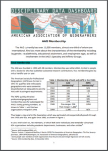
AAG Membership Data Summary Report downloaded from the Disciplinary Data Dashboard.
AAG Departments Data. Data found in this section comes from The Guide as well as the National Center for Educational Statistics. It includes information about geography programs in departments throughout the Americas as well as figures for the numbers of geography degrees conferred. Results of diversity surveys sent to geography departments are also located here.
AAG Workforce Data. This section is a work in progress, but includes a link to our Salary Data & Trends website featuring data on over 90 occupations related to geography. We also plan to have a report soon on our Jobs in Geography (JIG) website providing analysis of job ads posted to the AAG online job board over time and several other reports related to geographers in the workforce
Special Surveys. This section includes links to non-annual surveys on various topics, usually linked to grant-funded AAG projects.
AAG Annual Meetings. This includes raw data and analytical reports on AAG Annual Meetings held since 1904, including venues, attendance, international participants, session/paper topics, Presidential addresses, and more!
AAG Journals Data. This section is also still a work in progress, but will eventually include raw data and an analytical report on the four AAG peer-reviewed scholarly journals: The Annals of the American Association of Geographers, the Professional Geographer, the AAG Review of Books, and GeoHumanities.
AAG Archival Data. This includes information on how to access archival council reports/minutes, records of past AAG Annual Meetings, AAG journals/newsletters, and the “Geographers on Film” series (a collection of interviews with hundreds of influential geographers since 1970).
The Disciplinary Data Dashboard is categorized by source (left column) or by theme (right column).
Important Note about the Disciplinary Data Dashboard Structure. Data is categorized by source in the left column and searchable by theme in the right column. The goal is to make it more intuitive for particular audiences (students, researchers, etc.) to know where to look for specific data resources. The section searchable by theme also includes some externally-collected data and resources from outside of the AAG such as data from The College Board on high school Advanced Placement (AP) programs or The Social Science PhDs-5+ Years Out survey from the Center for Innovation and Research in Graduate Education (CIRGE).
The Disciplinary Data Dashboard is a valuable resource both to those browsing for more information about geography, but also for those pursuing in-depth research on the discipline. The amount of free, raw datasets available could easily support and be the foundation for research projects and publications!
The AAG Snapshots series, first launched at the 2017 Annual Meeting, provides insight on and information about different aspects of the projects, programs, and resources of the association. Do you have suggestions for future Snapshots content from AAG staff? Email cluebbering [at] aag [dot] org.
Robert J. Mason, a professor in the Department of Geography and Urban Studies at Temple University, died on November 15, 2017.
Rob was known for his work on environmental policymaking and land use management. He believed in international educational opportunities for students and was passionate about teaching the next generation of environmental leaders. A prolific author, Rob published Collaborative Land Use Management: The Quieter Revolution in Place-Based Planning (Rowman & Littlefield, 2008), Contested Lands: Conflict and Compromise in New Jersey’s Pine Barrens (Temple University Press, 1992) and the Atlas of United States Environmental Issues (Macmillan, 1990, with Mark Mattson).
In addition to teaching at Temple University, Rob has taught at Ohio State University, Temple University Japan in Tokyo, and Kobe College in Nishinomiya, Japan. In 2016, Rob taught at Temple Rome. He was serving a three-year term as Regional Councillor of the American Association of Geographers and had previously served as President of the Middle States Division of the AAG. He also served for many years on the Board of Directors of the Kobe College Corporation/Japan Education Exchange including as Co-President.
Rob earned his doctorate in Geography from Rutgers University in 1986, received a master’s in Geography and Environmental Studies from the University of Toronto, and held a bachelor’s in Geography and Environment Studies from the University of Buffalo.
Carol L. Hanchette, Associate Professor of Geography at the University of Louisville, died unexpectedly on a hiking adventure in the mountains of Wyoming on October 9, 2017. Hanchette received her Ph.D. from the University of North Carolina Chapel Hill in 1998 after having worked in a variety of fields including archeology and as a land surveyor for Billings, MT. She joined the University of Louisville in 2002. Hanchette’s work as an applied medical geographer cut across a wide-range of topics which included the links between ovarian cancer and pulp and paper manufacturing in the U.S., and the effects of coal ash on children. Her 1992 study on prostate cancer and ultraviolet radiation, cited over 700 times, was considered an important contribution to the field. More recently, Professor Hanchette had taken an interest in social and environmental justice and the uses of Qualitative GIS. Her work was funded by the National Institute of Environmental Health Sciences and the NIH.
Hanchette was particularly active in the development of the applied master’s program at U. of L. Her vision and passion structured that program from the ground up. Her leadership and popularity with students is well reflected in the many recognitions she received including the Faculty Favorite Award, the Distinguished Service Award and the Community Engagement Faculty Award. Carol was a long-time member and local leader of the Sierra Club. In addition, she loved hiking, ice skating, kayaking and almost any activity outdoors. Her collegiality, professionalism and dedication to geography will be missed by all of the lives she impacted.
Every month the AAG compiles a list of newly-published books in geography and related areas. Some are selected for review in the AAG Review of Books.
Publishers are welcome to send new volumes to the Editor-in-Chief (Kent Mathewson, Editor-in-Chief, AAG Review of Books, Department of Geography and Anthropology, Louisiana State University, Baton Rouge, LA 70803).
Anyone interested in reviewing these or other titles should also contact the Editor-in-Chief.
2018 AAG Annual Meeting Presidential Plenary Announced
The AAG announces the 2018 annual presidential plenary session from its current president, Derek Alderman, as well as a panel of esteemed scholars. The presidential plenary is currently slated to take place during the 2018 AAG annual meeting on Tuesday, April 10, 2018 in the Grand Ballroom at the Sheraton Hotel from 6:30 -8:30 p.m.
Alderman will present When the Big Easy Isn’t So Easy: Learning from New Orleans’ Geographies of Struggle. Beyond merely providing hotels, restaurants, and bars, the hosting cities of AAG meetings offer important moments to delve into the scientific value of these locations and to learn about the historical and contemporary forces and tensions that shape their communities and spaces. Doing so not only advances our intellectual understanding of place but also has the potential to create a more responsible and empathetic visitor and academic conference citizen—someone who can appreciate, analyze, and be affected by the people and places that exist beyond tourism brochures found in hotel lobbies.
When the Big Easy Isn’t So Easy creates a space to explore the role of struggle in the making, unmaking, and remaking of New Orleans. The city’s development has long been a power-laden process in which multiple identities, histories, and social interests converge, mix, but also clash. A wide range of racial, ethnic, class, and environmental struggles have shaped New Orleans in complex ways, making it a site of vulnerability, inequality, and displacement and at the same time a place of resourcefulness, creative surviving and living, and social justice activism.
Panelists, all of whom are civically engaged scholars and gifted geographic storytellers, will highlight not only the (Post) Katrina experience but also the deeper historical and geographic roots of struggle in New Orleans. They will take the audience to evocative spaces and moments, using the opening session to open broader discussions of issues such as black lives and geographies, disaster response and recovery, food justice, water-society relations, the politics of public memory, and urban political economy. Panelists will reflect on the larger academic-political lessons from New Orleans, offer ideas for (re)imagining the future of this city and others, and demonstrate how geographers can learn from and with the host cities for our AAG meetings.
Craig Colten, LSU. One of the perennial experts on NOLA and Louisiana history of human-environment/water-society relations.
Richard Campanella, Tulane University. Author of AAG’s ongoing features on NOLA and widely published local expert.
Michael Crutcher, Jr, Independent Scholar. Long-time expert on NOLA and author of book on Treme neighborhood.
Catarina Passidomo, University of Mississippi. Emerging scholar in southern studies, food geography/justice, and wrote dissertation on post-Katrina NOLA.
Rebecca Sheehan, Oklahoma State University. Has worked extensively as of late on the controversial removal of Confederate monuments from NOLA.
A Glance at New Orleans’ Contemporary Hispanic and Latino Communities
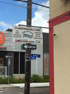
Las Acacias, a Latino market located in the revitalized Freret Street District in Uptown. Photo credit: James Chaney
Situated near the mouth of North America’s largest river, New Orleans has long served as a major port that advantageously connects the United States’ heartland to the rest of the world. Proximity and access to the Gulf of Mexico strategically place the Crescent City between the large consumption economy of the United States and the extraction economies of Latin America, which have historically been key purveyors of raw materials and commodities to the markets of their northern neighbor. Also, New Orleans served as a jumping off point for numerous military expeditions in the nineteenth and twentieth centuries that altered the political landscape of Latin American countries. Yet, even before becoming an “American” city, New Orleans was governed by the Spanish via Cuba (1762―1803). These economic, political, and historical linkages to Latin America and beyond have facilitated the transnational flows of people, products, and cultures over the course of four centuries and have cultivated the unique multinational ethnic kinship the port city holds today with Latin America and Spain [1]. Evidence abounds of these Hispanic and Latino ties in the cultural landscape, especially in one of the Big Easy’s most notable cultural productions: music [2]. Similarly, visitors with a keen eye will be able to discern the Latin American imprint woven into the urban fabric stretching from the French Quarter to the western suburb of Kenner and the riverbanks of St. Bernard Parish [3].
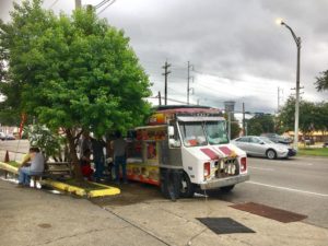
A taco truck on Claiborne Avenue near The Home Depot still serves Latino laborers more than a decade after Hurricane Katrina. Photo credit: James Chaney
Contemporary Latino migration and settlement in the southern United States have received considerable scholarly attention―particularly from geographers―over the past three decades. The “Nuevo South” moniker was coined to describe this supposedly new migratory phenomenon taking place. However, before Hurricane Katrina in 2005, New Orleans was often left out of discussions on southern destinations for Latinos, even though it was home to one of the oldest and most diverse Latino populations in the country. Perhaps the lack of attention was because the metropolitan area’s Latino population was relatively stable and mostly integrated. Of the 58,545 Latinos enumerated in Census 2000, four out of five were U.S citizens, more than half were born in the United States, and Latino household incomes were only slightly below the region’s average [4]. Therefore, New Orleans’ Latinos didn’t fit the narrative of a “New Latino South” so often applied to describe emerging Latino communities made up of and sustained by recent immigrants looking for new opportunities. But, in the wake of Katrina, New Orleans gained national attention seemingly overnight as Latino immigrants from Mexico, Central America, and as far away as Brazil and Peru flocked to southeast Louisiana to participate in the reconstruction efforts. Many arriving laborers were undocumented, taking advantage of the temporary suspension of federal and state enforcement of employment eligibility verification. While a study conducted by scholars from Tulane and Berkeley estimated that 14,000 Latinos laborers arrived within the first few months after the storm, local community leaders, social workers, and others engaged in the reconstruction efforts suggested much higher figures. In any case, this demographic phenomenon caught the attention of local officials, denizens, and national media. A Newsweek article posed the question, “Will Latino day laborers locating in New Orleans change its complexion?” [5]. Then-mayor Ray Nagin infamously asked himself in front of a town hall audience, “How do I ensure New Orleans is not overrun with Mexican workers?”. Indeed, Latinos became a prominent fixture in the metropolitan area in the years following Katrina. As laborers gutted and rebuilt flooded homes, taco trucks appeared throughout the city, and new tiendas, taquerías, pupuserías and Latino-themed night clubs opened across Orleans and Jefferson Parishes. Likewise, numerous Latino-focused nonprofits and religious organizations launched legal and language services designed to help arriving Latino immigrants settle and integrate into southeast Louisiana.
New Orleans certainly emerged more Latino than before the storm. Census 2010 counted 91,922 Latinos in the seven-parish metropolitan statistical area―an increase of 57 percent since 2000. But, as reconstruction effort came to an end, the surge of Latino workers that arrived after Hurricane Katrina appears to have receded. According to the Mexican consulate―which reopened in New Orleans in 2008 amid a new demand for administration and diplomatic functions for Mexican nationals in Louisiana and Mississippi―consulate employees were handling 80 to 100 appointments a day in the first years after the storm. Lines regularly formed outside the consulate’s location in the central business district, as Mexican immigrants waited to renew passports or matriculas, or to access other services. A decade later, however, appointments average between ten and fifteen daily which has led the consulate to scale back its number of employees. As demand for construction workers declined, some Latino laborers moved elsewhere within Louisiana such as Baton Rouge, Gonzales, and Alexandria while others relocated to states like Texas, Tennessee, Mississippi, Georgia and Florida and still others returned to their countries of origin.
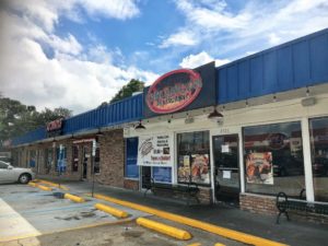
Taquería Chilangos Restaurant shares a small shopping center with Las Carnitas Restaurant which specializes in Central American and Peruvian food. Photo credit: James Chaney
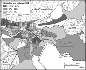
Although the initial intensity of post-Katrina Latino migration may have subsided, it certainly reinvigorated existing Latin American communities. This is most evident in the metropolitan area’s four core parishes of Orleans, Jefferson, St. Bernard, and Plaquemine which are home to 76,129 Latinos as identified by Census 2010. The settlement and integration of post-Katrina Latinos have put new emphasis on Latin American culture, which has led to new restaurants, stores, festivals, and radio programs that cater to an established ethnic community. Yet, many of the new Latino establishments have found success serving a larger non-Latino clientele. For example, David Montes de Oca, a Mexico City native, came to New Orleans via Houston with a taco trailer in tow. His first patrons were day laborers living and working in suburban Jefferson Parish. Yet in 2007, Jefferson Parish officials began passing measures to restrict street venders. Montes de Oca responded by opening a brick-and-mortar restaurant called Taquería Chilangos in a shopping center home to other Latino-owned businesses in the 2700 block of Roosevelt Boulevard in Kenner. Taquería Chilangos built a strong customer base by serving typical Mexican fare and earning a reputation for the best authentic tacos in New Orleans. Another example is Norma’s Sweets Bakery at 2925 Bienville Street in New Orleans’ Mid-City neighborhood which opened following Katrina to serve the growing number of Latino residents in the area. The bakery’s menu includes a variety of Latin American pastries and lunch options, but Norma’s Sweets becomes a favorite destination for non-Latino customers during Carnival season for its Cuban-style king cake filled with cream cheese and guava paste.
The Hispanic and Latino Population of New Orleans as a proportion of the total population of each census tract 2010. Map credit: Case Watkins
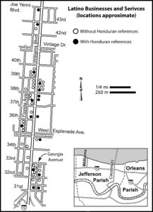
Perhaps one of the more interesting facets of New Orleans’ post-Katrina Latino geographies is the resurgence of Honduran population. New Orleans and Honduras share a long history starting with the once-ripe banana trade. The port city also served as a gateway for Honduran immigration. By the mid-twentieth century, Honduran immigrants residing in the Lower Garden District’s Irish channel neighborhood reached a critical mass, and, within the Latino community, the area became known as the Barrio Lempira (named after Honduras’ currency). By the 1960s and 1970s, upwardly mobile Hondurans were moving to the Mid-City neighborhood and by the 1980s and 1990s many relocated to suburban communities of North Kenner and Metairie in Jefferson Parish. Although the mid-century decennial censuses did not disaggregate persons of Honduran origin, Hondurans were considered the prominent Latin American nationality in the metropolitan area―so much so that erroneous claims of mythic proportions stating that 100,000 Hondurans lived in New Orleans or that New Orleans was home to largest the Honduran community in the United States, became commonplace. Of course, later censuses that enumerated Hondurans proved these assertions false. Census 2000 counted only 8,112 Hondurans in the metropolitan area, more than two-thirds of which were found in Jefferson Parish. In fact, the metropolitan area’s Mexican population had grown larger, numbering 10,202. But following Katrina the number of Hondurans soared. By 2010, Hondurans could accurately claim to be the largest Latin American nationality with a census count of more than 25,000—around 4,000 more than the enumerated 20,729 persons claiming Mexican origin at that time. Although visible residential and small business clusters are found in Jefferson Parish, which is now home to three-quarters of the area’s Honduran population, many newcomers settled in other sectors of the metropolitan area, even venturing into eastern New Orleans neighborhoods like Village de L’Est home to the city’s Vietnamese community and extending as far as St. Bernard Parish. (Figure 5)
Latino Businesses and Services in the William Boulevard, North Kenner. Map credit: Andrew Sluyter
Today New Orleans’ Honduran identity and sense of place manifest themselves in various ways. St. Teresa de Avila Catholic Church on Erato Street, which served the Hondurans and other Latin Americans Catholics who lived in the Barrio Lempira, features a statue of Our Lady of Suyapa, the patron saint of Honduras. The church hosts an annual festival in her honor on February 3rd celebrating the virgin as does the Immaculate Conception Church in Marrero on the West Bank where children perform national dances in traditional dress. More frequently, Hondurans gather each weekend in public parks, most notably City Park in Mid-City, to play soccer. For those looking for authentic Honduran cuisine, numerous restaurants can be found throughout the metropolitan area; however, Casa Honduras at 5704 Crowder Boulevard in New Orleans East is noteworthy. Not only does Casa Honduras offer typical Honduran dishes, it serves traditional Garifuna food and drink such as sopa de caracol con coco (coconut curry conch soup) and gifiti (a drink made with rum, herbs, and spices). Casa Honduras has become a de facto cultural center for New Orleans’ Garifuna community and periodically hosts Garifuna musical performers and events [6]. For visitors interested in Afro-indigenous culture from Central America, a meal at Casa Honduras is worth the trip.
Despite Hondurans being the largest Latino group in the metropolitan area, they account for only a little more than a quarter of the total contemporary Hispanic and Latino population. New Orleans has long been home to an assorted Latin American population. Through commerce, social networks, and geopolitics, or due to natural disasters, different groups have arrived to make the city their home, beginning with Los Isleños who first settled in the area in 1778. Indeed, most groups are less conspicuous when compared to the Hondurans and Mexicans, yet they have all contributed the creation of a distinctive pan-Latino identity in the city. While some national-origin groups populations have waxed and waned through the years, others have continued to grow. Between 1980 and 2010, the number of Nicaraguans, Guatemalans, and Salvadorans doubled, and the number of Cubans has slightly increased to 6,440 since 2000. Brazilian immigration to New Orleans began with the coffee trade in nineteenth century. The number of Brazilians in the city, however, was small until post-Katrina reconstruction efforts attracted thousands of Brazilians from other U.S. cities like Boston and Atlanta as well as Brazil. The surge was brief, and many Brazilians left within the first few years following the storm. Nevertheless, those who stayed have established a Brazilian community anchored in Kenner and Chalmette in St. Bernard Parish. A notable establishment for those seeking authentic Brazilian fare such as Feijoada is the Brazilian Market and Café at 2424 Williams Boulevard in Kenner.
While each national-origin group seeks to maintain its own traditions and character, a pan-ethnic identity has emerged to unify those of Hispanic and Latino heritage. Media outlets such as Jambalaya News, Radio Tropical Caliente, and LatiNola.com provide news and entertainment programming in Spanish and work to connect local Latinos with the larger New Orleans community. The Hispanic Heritage Center sponsors Latin American-themed cultural activities and artists in the region and provides scholarships to promising Hispanic high school students. Other annual Latino festivals like Que Pasa Fest, Kenner’s Hispanic Summer Fest, and Carnival Latino attract large numbers of both Latino and non-Latino visitors. Finally, nonprofit and religious organizations like Puentes, Congreso de Jornaleros, and the Archdiocese of New Orleans Hispanic Apostolate advocate on behalf of Latino immigrants (particularly undocumented) and, in turn, help to foster a stronger sense of a pan-Latino community. Thus, as the composite and size of New Orleans’ Hispanic and Latino community will undoubtedly continue to fluctuate, it will remain a significant and dynamic component of New Orleans’ society and unique culture.
[1]. “Hispanic” designates an individual or group of Spanish-language heritage. “Latino” identifies an individuals or groups from Latin America of Spanish- or Portuguese-language origin. For a more detailed analysis of New Orleans’ Hispanic and Latino populations and heritage see Hispanic and Latino New Orleans: Immigration and Identity since the Eighteenth Century. (2015) Andrew Sluyter, Case Watkins, James P. Chaney, and Annie Gibson. Baton Rouge: Louisiana State University Press
[5]. Arian Campo-Flores (2005) A New Spice in the Gumbo: Will Latino Day Laborers Locating in New Orleans Change its Complexion? Newsweek. 147(23): 46.
[6]. The Garifuna (or more correctly the Garínagu) are mixed-race descendants of African, Island Carib, European, and Arawak peoples who are found mainly in Honduras, Nicaragua, Belize, Guatemala, the island of St. Vincent and, since the twentieth century, the United States. For more information about New Orleans’ Garifuna community see James Chaney (2012) Malleable Identities: Placing the Garínagu in New Orleans. Journal of Latin American Geography 11(2): 121-144. DOI:10.1353/lag.2012.0049
Shane Colgan recently completed his bachelor of science in Geographical Sciences from the University of Maryland, College Park. He will be attending the University of Maryland, College Park to pursue his masters in GIS starting this upcoming Spring semester. His geographic research deals with vegetation indexes and tree top canopy analysis to document the habitat of bats in Maryland, Virginia, and Delaware.
When not at work or doing research Shane enjoys watching the Capitals ice hockey team.
AAG Members get exclusive access to publications, prominent journals, unique advocacy, grant, scholarship and professional opportunities with access to industry focus communities, and event discounts, including our annual meeting.
Some content may only be accessible if you belong to specific Specialty or Affinity Groups. You can still update your membership below. You will need to go through the Join flow, but you do not need to repurchase your membership unless it is expired or about to expire.
To provide the best experiences, we use technologies like cookies to store and/or access device information. Consenting to these technologies will allow us to process data such as browsing behavior or unique IDs on this site. Not consenting or withdrawing consent, may adversely affect certain features and functions.
Functional
Always active
The technical storage or access is strictly necessary for the legitimate purpose of enabling the use of a specific service explicitly requested by the subscriber or user, or for the sole purpose of carrying out the transmission of a communication over an electronic communications network.
Preferences
The technical storage or access is necessary for the legitimate purpose of storing preferences that are not requested by the subscriber or user.
Statistics
The technical storage or access that is used exclusively for statistical purposes.The technical storage or access that is used exclusively for anonymous statistical purposes. Without a subpoena, voluntary compliance on the part of your Internet Service Provider, or additional records from a third party, information stored or retrieved for this purpose alone cannot usually be used to identify you.
Marketing
The technical storage or access is required to create user profiles to send advertising, or to track the user on a website or across several websites for similar marketing purposes.
To provide the best experiences, we use technologies like cookies to store and/or access device information. Consenting to these technologies will allow us to process data such as browsing behavior or unique IDs on this site. Not consenting or withdrawing consent, may adversely affect certain features and functions.
Functional
Always active
The technical storage or access is strictly necessary for the legitimate purpose of enabling the use of a specific service explicitly requested by the subscriber or user, or for the sole purpose of carrying out the transmission of a communication over an electronic communications network.
Preferences
The technical storage or access is necessary for the legitimate purpose of storing preferences that are not requested by the subscriber or user.
Statistics
The technical storage or access that is used exclusively for statistical purposes.The technical storage or access that is used exclusively for anonymous statistical purposes. Without a subpoena, voluntary compliance on the part of your Internet Service Provider, or additional records from a third party, information stored or retrieved for this purpose alone cannot usually be used to identify you.
Marketing
The technical storage or access is required to create user profiles to send advertising, or to track the user on a website or across several websites for similar marketing purposes.


 Additionally, the AAG has kicked off a brand new resource to highlight geographers interested in and available to give presentations on various aspects of geographic thought and research. The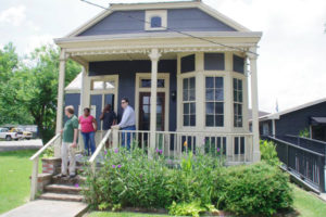


 Alderman will present When the Big Easy Isn’t So Easy: Learning from New Orleans’ Geographies of Struggle. Beyond merely providing hotels, restaurants, and bars, the hosting cities of AAG meetings offer important moments to delve into the scientific value of these locations and to learn about the historical and contemporary forces and tensions that shape their communities and spaces. Doing so not only advances our intellectual understanding of place but also has the potential to create a more responsible and empathetic visitor and academic conference citizen—someone who can appreciate, analyze, and be affected by the people and places that exist beyond tourism brochures found in hotel lobbies.
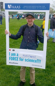 Shane Colgan recently completed his bachelor of science in Geographical Sciences from the University of Maryland, College Park. He will be attending the University of Maryland, College Park to pursue his masters in GIS starting this upcoming Spring semester. His geographic research deals with vegetation indexes and tree top canopy analysis to document the habitat of bats in Maryland, Virginia, and Delaware.