Every month the AAG compiles a list of newly-published books in geography and related areas. Some are selected for review in the AAG Review of Books.
Publishers are welcome to send new volumes to the Editor-in-Chief (Kent Mathewson, Editor-in-Chief, AAG Review of Books, Department of Geography and Anthropology, Louisiana State University, Baton Rouge, LA 70803).
Anyone interested in reviewing these or other titles should also contact the Editor-in-Chief.
PLEASE NOTE: Due to current public health policies which have prompted the closing of most offices, we are unable to access incoming books at this time. We are working on a solution during this transition and will continue our new books processing as soon as we can. In the meantime, please feel free to peruse previous books from our archived lists.
Geomorphologist Cuchlaine King died on December 17, 2019 at the age of 97. As a member of the geography department at Nottingham University since 1951, King’s studies addressed many landforms and landscapes, particularly beaches and glaciers.
At a time when scientific expeditions to remote locations were often closed to women, in 1953 she embarked on a university expedition to Iceland to study and survey glaciers. Later in the 1950s,and 1960s, she took part in the Cambridge expeditions on the Austerdalsbreen glacier in Norway and the Baffin Island, in Canada.
Cuchlaine was born in Cambridge,where she later went on to study geography at Newnham College, graduating in 1943. Cuchlaine’s publications include Beaches and Coasts (1959), Techniques in Geomorphology (1966), and Glacial and Periglacial Geomorphology (1968). She was an early proponent of “quantitative geography”, the use of numerical and statistical techniques to describe and explain landform development. In 1961, Cuchlaine became one of only two women in the founding group of academics that became the British Society for Geomorphology. In 1981 she was awarded the Linton prize from the BSG for her contributions to the subject.
Cuchlaine is survived by a niece, Jane, and three nephews, Nicholas, Timothy and John.
Complex organizations have complex interests and responsibilities, especially in the 21st century. My October 2018 Column reminded us to keep our eyes on the prize of equity for all. Together, we Geographers have worked diligently over the last several years to shine a light on equity and banish harassment and bullying from our meetings, our places of work, and our lives. We have more work to do, but we do have a heightened awareness, and a strong, renewed resolve to move forward with justice. Even though we have a strong Statement of Ethics (2009) condemning workplace harassment and discrimination, we further renewed our resolve to fight bullying and harassment with the Harassment Free AAG Initiative of 2019 (Please also remember to take the Post-Meeting Survey). And we will keep working to improve the climate for all. While keeping an eye on our social and civil well-being, the well-being of our planet also needs our attention and actions as strongly as ever. Protecting the civil rights and human rights of scientists helps to advance and protect science, to the benefit of people and the planet.
Headlines are just as alarming on the environmental justice side of the scales as they are on the social justice side. A recent email correspondent offers fair points regarding institutions and fossil fuel divestment, but implied that AAG is neglecting the environment because of our recent focus on anti-harassment initiatives. We should not be forced to make a false choice between the workplace climate, the atmosphere, and our fiduciary responsibility to members and donors as a non-profit, among others. AAG has invested in a portfolio of green funds, and it is worth thoughtful consideration of additional long-term, planet-healthy investment strategies, absolutely. We must of course maintain a complementary balance of Planet Earth’s and her Inhabitants’ well-being. Our AAG Logo and flag, after all, are green.
Recent headlines and reports include this week’s news that atmospheric carbon dioxide concentrations have hit an all-time high of 415 ppm (Washington Post, 5/14/19). That concentation is the “…highest level in human history” (WaPo 5/14/19). Other headlines include news that “humans are speeding extinction and altering the natural world at an ‘unprecedented’ pace” (NY Times 5/12/19).
In light of these daunting global trends, members of the U.S. Congress, led by Rep. Alexandria Ocasio-Cortez and Sen. Ed. Markey have proposed a non-binding resolution, the Green New Deal. The Green New Deal does not pit society against the environment, but blends the well-being of both by resolving to “reduce greenhouse emissions…to avoid the worst consequences of climate change while also…addressing “societal problems like economic inequality and racial injustice.”(New York Times, 2/21/19).
The plan encompasses five main goals to:
“invest in sustainable businesses”;
“Move to 100% clean energy by 2030”;…
“Create a Commission…to provide publicity, training, education and direct financing” for projects and reforms;
“Establish a renewable Energy Administration” modeled after Roosevelt’s “Rural Electrification Administration”; and
Create a “Full Employment Program… a direct employment initiative to guarantee jobs and a living wage for every American…” (See this link for the Full Plan Language).
Geographers’ diverse talents and insights can contribute in all of these areas.
Within the AAG’s ranks, there are also renewed Green goals. AAG passed a Resolution Requesting Action on Climate Change in 2006. In Spring 2019, a group of members have pointed out that much has changed in the last 13 year since that resolution, and it is time to strengthen our commitment to fight climate change. This monumental effort was led by Geographers Rutherford H. Platt, Ian Burton, Susan Cutter, James Kenneth Mitchell, James L. Wescoat, Claire Rubin, and Martin A. Reuss. The group sent a new Resolution on Climate Change to Council, which was passed unanimously at the April 2019 AAG Meeting. The new Resolution was rooted in the legacy of Geographer and National Academy of Sciences Member Gilbert White (1911-2006), for whom a special session was convened by the aforementioned panelists at the 2019 Annual AAG Meeting. Dr. White’s work showed compassion for people and the environment, with his pioneering work using planning policies to move people out of dangerous flood plains and save lives and property, as opposed to sole reliance on technological solutions to flooding and flood control. His floodplain management work is a great example of fulfilling the human right to benefit from science. The Green New Deal echoes this, incorporating smart business and social policy solutions to improving the environment, the economy, and people’s well-being together. The new AAG Climate Change Resolution promotes 8 goals to fight climate change, compatible with the Green New Deal, summarized at the AAG Website 2019 AAG Climate Resolution for full details. Many thanks to the authors, and to the AAG Council for supporting this.
Future Geograph-ies/-ers
It is graduation time and the goals of social and environmental justice should inspire the new generation of Geographers who are graduating this month from our institutions. We welcome them to the company of scholars and professionals, and we encourage them to carry the torch forward, to create a better social, physical, and technological world, and a brighter future. We also need to continue lending our full support as senior scholars and professional mentors for the latest generation of Geographers, in whom I have great hope, confidence, and inspiration. I end this column with my very best wishes and gratitude to my students who will always be members of our home departmental community, and to all students at this important time of transition in your lives. Congratulations to all, and to those who share in your success!
— Sheryl Luzzadder-Beach
President, American Association of Geographers
Professor, Geography and the Environment and C.B. Smith Fellow in US-Mexico Relations, University of Texas at Austin
Feel free to share your thoughts with me at: slbeach (at) austin (dot) utexas (dot) edu
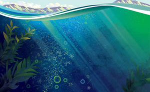
Deoxygenation of the Ocean Affects Everyone, So Act Now
By Dawn J. Wright, Esri, and Sylvia A. Earle, National Geographic Explorer-in-Residence
Did you know that more than half of the oxygen we breathe comes from the ocean? This oxygen is produced in large part by the photosynthesis of billions and trillions of small plants in the ocean called phytoplankton, as well as the blending of seawater with the atmosphere right at the ocean’s surface.
But the ocean is facing unprecedented pressures that are causing massive disruptions in the ecosystem and nutrient cycle of phytoplankton and countless other species—the result of an extensive, commercially driven depletion of ocean wildlife; industrial-scale pollution; and other human activities. This oceanic turmoil occurs on the seafloor via trawling, dredging, drilling, and mining. It also happens in the water column with nets, long lines, fish-aggregating devices, and other techniques.
Fishing methods like these were introduced over the last few decades to extract marine life with unprecedented speed and scale from ecosystems that were hundreds of millions of years in the making. As a result, they are contributing to the accelerated reduction of oxygen levels in the ocean, as well as in the air and on land all around it.
Indeed, overfishing of the ocean biomass has tremendous effects on the earth’s climate and carbon cycle. Restoring marine life, then, could have a huge impact not just on ocean health but on life on land as well. That is why the decline of oxygen in the ocean concerns absolutely everyone, no matter where we live.
Raising Awareness
There is comprehensive evidence that oxygen levels in open ocean and coastal waters have declined precipitously over the last half-century. According to a recent review article in Science entitled “Declining oxygen in the global ocean and coastal waters,” by Breitburg et al., oxygen in the ocean is currently dropping faster than can be accounted for by physics. This suggests that respiration—the intake of oxygen followed by the release of carbon dioxide—must be increasing. However, a good portion of this decline in oxygen may, in fact, be due to the disruption or destruction of tiny microbes in the ocean.
Scientists definitely need new insight into how changes in oxygen within the ocean are affecting the pathways and processes of these microbes at all depths. The extent to which the system is out of balance is becoming clear, and the pace of this change—as well as how widespread the impacts are—is alarming. We humans cannot afford to wait to take action.
Fortunately, ocean science has many integrated frameworks that combine observations, experiments, modeling, and GIS mapping from scientists, local governments, intergovernmental bodies, and business sectors. These are raising people’s awareness of the pervasiveness of issues such as ocean warming and acidification, as well as the ever-increasing presence of microplastics in the water.
Now, scientists need to raise awareness about how quickly the oxygen is dissipating. But such awareness must spread beyond the pages of scientific journals so it permeates all facets of society. Web maps and visualizations that are intuitive, interactive, and dynamic have the power to do this, driving the point home to a variety of audiences.
The Ecological Marine Units (EMUs) digital ocean project, for example, gives anyone access to millions of observations of the oxygen dissolved in water all over the ocean. Accessible at esri.com/ecological-marine-units, the EMUs also show each body of water’s temperature; salinity; and nitrate, silicate, and phosphate concentrations—the likely drivers of many marine ecosystem changes. Some major goals of this project are to support marine biodiversity conservation assessments; aid in research about the economic valuation of marine ecosystem goods and services; and contribute to studies on ocean deoxygenation, acidification, and other environmental impacts.
Another great resource for raising awareness is the Marine Conservation Institute’s interactive Atlas of Marine Protection, also known as the MPAtlas, available at mpatlas.org/map/mpas. Momentum is accelerating to designate very large marine protected areas (MPAs) throughout the ocean, and research suggests that sizable MPAs are much more cost-effective to implement and manage compared to smaller ones. Furthermore, larger MPAs generally provide better protection from activities that occur outside of them, since, even though they safeguard a great number of organisms, so many marine animals—especially fish—are constantly on the move across large sections of the ocean. If those organisms can find shelter and stability within large MPAs, they stand a better chance of enduring once they leave them.
These online resources will be key to generating the societal and political will to effectively manage marine habitats in ways that will ultimately reverse the declining levels of oxygen in the ocean and mitigate the serious consequences this has for ocean life and ecosystems. Additionally, the International Union for Conservation of Nature (IUCN), in collaboration with world experts, is coordinating the production of a comprehensive report called Ocean Deoxygenation—Everyone’s Problem: Causes, Impacts, Consequences and Solutions that will further summarize the challenges and implications we face. The IUCN plans to distribute this report far and wide—to government agencies, conservation organizations, citizen groups, and universities.
We must connect important discoveries about the nature of the world with public perception and current policies that shape the habitability of the earth. The global trend by countries all over the world to secure large areas of the ocean within national exclusive economic zones (EEZs) and create “blue parks” as safe havens for ocean life are also reasons to be optimistic, since protecting nature protects human existence.
What to Do Now
So what can you do to stem the tide of ocean deoxygenation? How can you connect the dots and take action to reverse some of the present destructive trends? Consider some of the following options:
This summer, visit a blue park in person to gain a fuller appreciation of the life-giving resources the ocean provides—including oxygen!
Join forces with the Sylvia Earle Alliance’s Mission Blue movement and other similar causes that showcase many of these blue parks. With Mission Blue, anyone can nominate a section of the ocean to become a blue park, also known as a Hope Spot, for protection and preservation. Soon, GIS content, such as the EMUs, will be included in this process.
Use the EMU Explorer apps, accessible at esriurl.com/emuapps, to study oxygen levels and other parameters throughout the ocean.
Use the MPAtlas to see other current areas of protection.
Watch episodes of the BBC’s Blue Planet II series, which wonderfully educates viewers about the nature of the ocean, including scientific evidence of the many ways our ocean is declining due to human activity.
Take simple steps to recycle or greatly reduce plastic use—especially straws; this affects the ocean no matter where you live because it all starts upstream with wind and water flows. Plastic pollution of waterways is intimately connected to declining oxygen levels in the ocean. Organizations such as Algalita Marine Research & Education, the Save the Albatross Coalition, the Aquarium of the Pacific, and the Marine Conservation Institute all provide excellent tips and resources.
There’s plenty to do to assist with marine conservation and help reverse the deoxygenation of our ocean. But we need to act now—because if there’s no blue, there’s no green, which means there will eventually be no humans. No kidding!
Editor’s note: This article is based on a letter published in the March issue of Science called “Ocean deoxygenation: Time for action,” by Sylvia A. Earle, Dawn J. Wright, Samantha Joye, Dan Laffoley, John Baxter, Carl Safina, and Patricia J. Elkus.
About the Authors
Dawn J. Wright is the chief scientist at Esri and a full professor of geography and oceanography at Oregon State University. Sylvia A. Earle is a National Geographic Explorer-in-Residence and the founder of the Sylvia Earle Alliance, an organization dedicated to safeguarding the ocean, and Deep Ocean Exploration and Research, which builds remotely operated vehicles used in ocean exploration.
Share
Hope Morgan
Education: Bachelor’s in Geography, Concentration in Earth Science (University of North Carolina at Greensboro), Certifications: GISP, Certified Floodplain Manager (CFM), Professional Land Surveyor (PLS) in North Carolina
Describe your job/position and some of the primary tasks and duties for which you’re responsible in this position. I have an extremely interesting job. I’ve been here for eleven years and it has morphed quite extensively. When I began I was the GIS manager and I managed all geospatial information that came into our office for either emergency response, floodplain mapping, or other applications through risk management. I am now the IT manager and GIS and IT work closely together, so my responsibilities include all applications including data with spatial association used inside of the risk management office. One of the biggest projects that I worked on was managing the collection of LiDAR data for the entire state of North Carolina, working with many federal, state, and local agencies, specifically the Department of Transportation. Hopefully by the end of this year we’ll have an entire surface to use for the state. Another was statewide collection of orthophotography in 2010 for the entire state.
Could you talk a little more about how those resources are being applied for risk management in the state? It sounds like a fascinating position that you’re in that’s gone through a lot of changes. In this field, we are constantly changing, constantly working to keep up with new technologies. We are working on a new project where they are processing 30 points per meter LiDAR, which is a massive amount of data. It requires updated software that can maintain and visualize that information so the public can use all of the information that we’ve gathered. The public in North Carolina has worked hard to make sure that they can utilize all of this information. It’s amazing to watch as people use the data for new and different things.
What substantive geographic knowledge is important and useful to know in your position? For example, this includes knowledge and understanding of geographic terminology and substantive concepts (e.g., alluvial plain, metropolitan area, ethnic group, tertiary economy, coniferous forest, geologic fault, etc.). I’m North Carolina-centric because I was born and raised here and I work for the state, so most of my working knowledge base of geography is based on North Carolina. With the LiDAR dataset, I’m working with many groups: forestry, Department of Transportation, commerce, property mappers that are creating plans at the local level. It helps to be able to understand the terminology that goes with each one of these groups. As we work through the different geography requirements for each one of these projects and processes, knowing the terminology is very important. The more you know, the easier it is to have a conversation. When I talk to students, I tell them, you don’t have to know everything, you’re going to learn a lot as you go, but you need that baseline of understanding so that when people start throwing terms at you, you understand what direction to go in and what research you need to do. One of the big projects we do is the flood plain mapping program, so I work with engineers quite often. I have learned more about hydrography, hydrology, water surface elevation, and other things that are relevant to this specific type of program. I use geography terms on a daily basis, often times without realizing I’m doing it.
When you started out in your job, coming out of your degree program, did you find that there were areas where you felt a little underprepared or needed additional training? Did you ever think “I wish I had more of that when I was a sophomore, or a junior, or a senior, in college,” or did you feel comfortable just learning as you went? I wish I would have paid a little more attention as a student. In school, it’s difficult because you’re in the middle of these classes, you’re tired, and you’re trying to get all of this stuff done. It’s important to try to stay focused and listen to what’s going on because every single thing that you do in school and every single class you take has some piece of information that you probably need to take with you.
In terms of how you’re working with technologies, in connection with some of those substantive areas of geography that you’ve been leaning on in your position, can you talk a little about how these connect or fit together? What are some applications that are being used now for risk management in the state and how is that department working with these technologies? On the emergency management side, we try to forecast what is going to happen during major events. We look at everything from hurricanes to nuclear boundaries to tornado paths to winter storms, and the biggest thing we are looking for is what’s in the way. If there is a flood, we look at who and how much is going to be in the way and what kind of damage is it going to cause. With storm surge, we try to figure out if the storm is going to cause some impact to the structure of the coast, such as erosion. In North Carolina, we are often looking at the Outer Banks and how they are impacted by storm surge. If the storm is going to run into structures, we look at water surface elevation and compare that to the building footprints to see how the water will impact the structures. That’s an example of how we use these technologies daily. We’re walking it all the way through a process from the physical to the impact to the dollar damage, and then we consider the people and the community to see how they can recover from this incident.
How would you describe the impacts of your work in this area of risk management on the state and in communities? Can you cite any specific examples in terms of positive impacts? Emergency management is built out of responders, so it is a group of people focused on solving problems like rescuing and helping people recover. Many people in emergency management are not used to using datasets to make decisions. We have worked very closely with our team members to answer questions ahead of events, planning makes it easier for them to respond to incidents that are occurring. After planning we automate as much as possible so that the answers the teams need automatically show up in our systems. Hurricane Matthew in 2016 was a good example. A large part of Hurricane Matthew was rain, and it rained a massive amount over a large portion of North Carolina. What we were able to do was use database decision making to respond to flooded areas. Our engineers could tell us when the water was going to arrive based on gages, so we knew where to send our limited resources as well as responders. I’m really proud of those first responders for working with us and taking on this new technology.
What is it about geography that inspires you and connects with your aspirations, both as a private citizen and as a professional in your field? In college, I wasn’t really sure what I wanted to do or where I wanted to go. I ended up looking at the courses I had taken and realizing that geography was where I had spent most of my time. I got my first job at a photogrammetry company after visiting it during one of my college classes. So my career began in photogrammetry and remote sensing, where I was working with orthophotography and planimetric collection. I am a spatial person, so I understand through visualization and pictures, and this work just really clicked for me. I guess that job was sort of my first a-ha moment that basically led me to this very hopeful path, where I try to have a lot of impact.
As I moved to state government, I have been so lucky to work with different groups of people that are doing amazing work in the state. We have a vast amount of work that’s being done with different imagery at the local level, day-to-day. And then on the emergency management side, with the ability to help during an event, we know that this information saves lives by helping us move people out of the way. We have been able to evacuate hospitals and jails and move towns that basically were going to be underwater, and we got those people out ahead of time. I am very lucky to be a part of that and do something that’s really helping North Carolina.
The other thing that is a big piece of what I want to do is make everybody’s job easier. I feel like this data and this understanding of how this information is built really does make things more efficient and makes decisions easier.
Is there anything else you’d like to share, in terms of general advice? My advice is to use the data that is provided by others. I really push to use the data that is available, for universities to take this data research and learn from it. They should learn how it works and make it do new and better things because it is a base set of information that can change how people think. Wherever you are, you can use the data that is available and learn how that data can make a change in how people see the world.
Every month the AAG compiles a list of newly-published books in geography and related areas. Some are selected for review in the AAG Review of Books.
Publishers are welcome to send new volumes to the Editor-in-Chief (Kent Mathewson, Editor-in-Chief, AAG Review of Books, Department of Geography and Anthropology, Louisiana State University, Baton Rouge, LA 70803).
Anyone interested in reviewing these or other titles should also contact the Editor-in-Chief.
PLEASE NOTE: Due to current public health policies which have prompted the closing of most offices, we are unable to access incoming books at this time. We are working on a solution during this transition and will continue our new books processing as soon as we can. In the meantime, please feel free to peruse previous books from our archived lists.
A World of Many Worlds by Marisol de la Cadena, Mario Blaser (eds.) (Duke University Press 2018)
Share
Amanda Sankey
Education: B.S. in Resource and Environmental Studies, Concentration in Geography (Texas State University, San Marcos), Minors in Communications and Geology (Texas State University, San Marcos)
Describe your job and the primary tasks and duties for which you’re responsible as an Environmental Consultant at Crouch Environmental Services, Inc.
Crouch Environmental is a small company of about 18 employees, divided into two departments: the Communications department and the Environmental department. I am responsible for managing projects relating to both teams.
In support of our Communications team, I help facilitate public meetings, deliver presentations, and produce high-quality materials featuring content that directly relates to environmental issues and events happening in the Gulf Coast region of Texas. This requires expertise in developing appropriate messaging tailored to audiences of varying backgrounds.
In support of our Environmental team, I secure different types of environmental permits so that my clients comply with the National Environmental Policy Act and other state and federal regulations. This requires a working knowledge and expertise across a wide range of environmental legislation. It also requires an understanding of hydric soils, native vegetation of the Texas gulf coastal plains, hydrological indicators, and understanding and abiding by U.S. Army Corps of Engineers policies and procedures.
What substantive geographic knowledge is important and useful to know in your position? For example, this includes knowledge and understanding of geographic terminology and substantive concepts (e.g., alluvial plain, metropolitan area, ethnic group, tertiary economy, coniferous forest, geologic fault, etc.) When I started out doing fieldwork for the environmental team, I used geographic terminology when mapping rivers and streams and characterizing biological environments. In this work I regularly used technical terms and concepts such as bank width, bank steps, ordinary high water mark, sediment sorting, discerning forest communities (a successional community or a mature forest), identifying types of forests and herbaceous communities (such as deciduous or hardwood pine forests), identifying active margins and passive margins, measuring riparian buffers, and identifying contours and benchmarks.
As I have integrated into our communications team, I have found an understanding of public needs relating to environmental justice, metropolitan areas, and limited English proficiency (LEP) to be crucial in serving our clients, as we often explain geographic concepts relating to water quality, flooding, watersheds, and drainage basins to the general public.
What conceptual geographic knowledge is important and useful to know in your position? For example, this includes using “big ideas” in geography such as location, place, region, interconnection, spatial relationships, etc., to think about people, places, and environments, from the local to the global. When operating under the Clean Water Act and the Rivers and Harbors Act, I rely heavily on my understanding of concepts relating to hydrologic flow in river basins. When I’m determining flow direction of waterways in my study area, I will often use clues in the landscape, including topographic gradients and dendritic drainage patterns in order to determine what is considered “upstream” and “downstream.” Signs of sediment or refuse collecting in the landscape can be really helpful when I am investigating a landscape.
Other spatial concepts I learned in environmental geography, such as eutrophication, help me figure out where certain wildlife species may be located. For example, if you have a lower dissolved oxygen content in certain areas, you are going to have different types of fish species present. Metrics like dissolved oxygen or presence of e. coli can also help identify potential contaminants present. These concepts are geographic in nature as they relate to the effect of drainage patterns in the landscape.
What procedural geographic knowledge is important and useful to know in your position? For example, this includes spatial analysis with a GIS or other geospatial technology, designing a geographic inquiry and research study, collecting spatial data in the field, etc. When I was in school, I actually had no intention of learning ArcGIS; however, it was a requirement for my degree at Texas State. I think the fact that I had a basic GIS class may have been what ultimately secured my position at Crouch Environmental when I first started interviewing with them. When I applied for a position at Crouch, their GIS person had just left for another company, and they asked if I could learn this skill quickly to take his place. Without that class, I’m not sure if I would have been able to initially land this job. This skill is extremely helpful to have in your arsenal regardless of what you plan to do with it.
As far as fieldwork goes, prior to heading to the field, the lead field biologist will determine how we will conduct the study based on the size and shape of the area. Our team of biologists will measure the edge of wetlands and the ordinary high water mark along streams by collecting data points with our GPS unit. Once they return from the field, the data is transferred from the GPS unit into ArcGIS. Our GIS specialist then maps out exactly where that stream was located based off of our field data.
In your time at Crouch Environmental, can you give specific examples of where geography really made a difference, and had an impact through the work of the company? Absolutely! What’s great about working at Crouch Environmental and the industry in general is the type of clients that we get to work with. We get to work a lot with public entities, like Harris County Engineering Department and Harris County Flood Control District, on a regular basis. These entities rely on our environmental studies, public involvement and facilitation, and coordination with leading agencies such as the Army Corps of Engineers in order to build public infrastructure projects such as roadways, utility lines, and storm water management detention basins. We get to help expedite environmentally conscious development that is crucial for supporting safe and efficient travel throughout Harris County.
What is it about geography that inspires you and connects with your aspirations, both as a private citizen and as a professional in your field? As a professional I really love the idea of identifying the least environmentally damaging, practical alternative that still allows people to meet their needs. It’s an evolving, exciting challenge that I get to partake in every day as an environmental consultant. Development is going to happen no matter what, and I get to help make sure that it happens in an environmentally consciousness manner. The credibility and weight that comes behind that is so important!
On a personal level I love that the biology side of my work is geographic in nature. It is a constant reminder of how organisms within the same space all impact each other. My understanding of geographic concepts allows me to take all the details from the raw data that we collect and put them into the bigger picture. The work we do is so important because it directly affects the quality of the streams and water that we drink every day. It amazes me how much we are affected by the world around us and by the different chemicals you’ll find wherever you are.
When did you first make the connection between geography and career possibilities and opportunities? I first got the idea about going into geography from my father, who also has a geography degree (he’s actually in my field too!). I saw geography as a career possibility early on, but I didn’t quite connect with it until college. In my environmental geography class, I had the opportunity to choose an environmental problem to research and present to the class. I studied the Chinese tallow tree, an invasive species common to the Houston area. From this experience, I learned that invasive species can pose major problems to native environments, and that these problems can be exacerbated by poor environmental management. I realized when I was doing that presentation and putting it all together that I could actually address some of these issues as an environmental consultant. Ever since then, it’s kind of been my path. It’s been three and a half years since I graduated and started with Crouch and I’m still happy to be here.
Beyond your work life, do you ever use your knowledge of geography to inform other aspects of your behavior or your personal life in terms of lifestyle, driving, public transit, shopping, etc.? Are there any other ways you find geography to have a personal value? Yes, yes, yes, yes, yes! I can’t say that enough! One big example that stands out in my mind was the fallout from Hurricane Harvey. This was a really scary event for everyone last year! Something I learned from my water resources class was how to pick where to live to minimize damage from flooding. I knew which public databases to go to and how to access information on floodplains and drainage to select a home with the best possible chance of staying dry during a major flooding event. I’d like to think this was a contributing factor in my home not incurring flood damage from Hurricane Harvey.
The Chesapeake Bay: Destruction and Rehabilitation in the Nation’s Largest Estuary
It’s another drizzly day on the Chesapeake, and the boat we are on bobs gently on the opaque, mud-colored water. A crusty old crabber from Tangier Island, by the nickname of Captain Cook (use of nicknames is an old and strong tradition on Tangier), has just dropped a scraper overboard and brought up a bunch of seagrass, which is dumped on a sorting table in front of us.
rCaptain Cook and the scraper
Our hosts are members of the Chesapeake Bay Foundation, and this is their educational boat. “We” are the crew of Hōkūle‘a, the Hawaiian voyaging canoe that recently circled the globe promoting the message of Mālama Honua—take care of the Earth. I met the canoe in Yorktown, Virginia on May 6, 2016. Two guests were already among us—Kirk Havens, the assistant director of the Virginia Institute of Marine Science, and his cousin Dan Havens from the Washington Canoe Club. We were joined the next night by the mayor of Tangier Island, James Eskridge (“Mr. Mayor”) and Captain Cook. Together we all set out from Yorktown the morning of May 8. As we approached the mouth of the York River, the great grey expanse of the Chesapeake Bay stretched out before us so far that we could not see the other side.
Because it is one of the earliest sites of continuous European settlement in the U.S., and because of the importance of its ecosystem, the Chesapeake Bay is an excellent example of how modern humans have mismanaged nature’s bounty. The Bay is the largest estuary in the United States, with a 64,000-square-mile watershed feeding fresh water into this salt-water inlet, resulting in a range of aquatic and marine ecosystems. “What makes an estuary more productive than coastal areas,” says Paul Willey, Director of Education Operations for the Chesapeake Bay Foundation and one of our hosts on this trip, “is the mix of fresh and salt waters. But what makes the Chesapeake Bay even more productive is that it’s shallow.” Average depth in the main portion is only about 30 feet, decreasing to 20 feet if you include the tidewater tributaries. “It’s just mind-boggling to think of how productive this bay was, even 150 years ago,” Paul adds.
When Captain John Smith sailed this bay four hundred years ago, the water clarity in the bay was exceptional, thanks to the natural filtration provided by oysters, wetlands, and submerged grass beds. Smith wrote that oysters “lay as thick as stones,” and the fish population included “sturgeon, grampus, porpoise, seals, stingrays … brits, mullets, white salmon [rockfish], trout, soles, perch of three sorts” and a variety of shellfish. The schools of fish could be so massive that at one point Smith and his men attempted to catch them with frying pans.
This was an ecosystem managed, to some degree, by the native peoples who lived in dispersed and shifting settlements throughout the region. Drawing on the bounty of the bay itself, as well as the abundant game on land and in the air, plus a variety of farming practices, the peoples of the Chesapeake left gentle footprints on the region compared with the Europeans who followed them.
The Europeans were colonists—coming with the intent to stay, to acquire and transform land, and to produce wealth in the form of cash money, within the context of the emerging global economy. That method of wealth production is pretty straightforward: find an environmental resource—fish, minerals, agricultural land, forests, whatever—and process it on as large a scale as possible to produce the most goods for sale. 400 years ago the impacts of that process on the planet were relatively small and usually recoverable. 400 years later, the bay is struggling with that very recovery.
Colonists set about clearing forests, plowing fields, spreading fertilizer, and interfering with the streams and waterways. The overflow of sediment and fertilizer, and the increase in streamflow from the reduced forest cover, clouded over the underwater grasses, while the increase of nutrients spawned the growth of microscopic algaes and planktons. This is true of estuaries world wide, and as Robert Carter writes, “The decline of estuaries, without a doubt among the planet’s most important nursery grounds, represents one of humanity’s greatest challenges and most obvious management failures.”
Fish wiers
The waters of the bay seem always to be brown with sediment, especially after a rain. As we made our way towards Tangier Island, we saw numerous fish wiers. These are sticks driven into the shallow bottom, holding nets in a funnel shape that guides fish into heart-shaped net pockets. This is the same technology used by Indians, as shown in this 16th-century drawing. The Indians began teaching the Europeans how to do it as early as 1608. Even today, the method is taught by oral tradition.
We didn’t reach Tangier Island that first night, but pulled in at Reedville. Here a Maine sea captain named Elijah Reed had set up shop to fish the vast school of menhaden. A member of the herring family, menhaden are filter-feeders that thrive on zooplankton and phytoplankton, thereby providing a key role in the Chesapeake ecosystem. They are an oily fish, not generally eaten by humans, but processed into fish meal, fish oil and fertilizer. Their incredible abundance in the mid 19th-century turned Reedville into one of the world’s leading fishing ports, with a per capita income among the highest in the United States.
That was then. Today Reedville looks like an odd mix of ghost town, fishing town, and suburb. The menhaden were declared overfished in 2012, owing mostly to the water quality of the bay. Factories have come and gone, leaving rotting carcasses of old warehouses and crumbling remnants of towers where ospreys make their nests. But sprawling old homes speak to the former wealth of the town, and fishing ships are still present. Reedville is also one of the few places where one can catch a ferry to Tangier Island. Master navigator Nainoa Thompson himself, and his entourage of two, joined us here.
In the grey haze and ultimately rain of the next day, we set out for Tangier. “Where are you from?” Mr. Mayor asked me. I told him I was born and raised in Washington, D.C. but that I now live in Baltimore. “Oh,” he said, and looked at his feet. “Then I guess you must be used to being around a whole lot of people.”
Tangier map
Tangier is one of a small group of islands forming a remote outpost in the Chesapeake Bay. It has a population of about 470 people, down from about 1,500 a century ago. Captain John Smith came across these islands in 1608. The island has had a colorful history since then, including a distinct dialect of Tidewater English closer to its British roots than mainstream USA. Much has been written recently about Tangier because of the conflicts over the crabbing industry—the mainstay of the island—and because the island, like the land all around and in the bay, is sinking due to tectonic forces. As such, it provides a model for climate-change-induced sea level rise.
We entered a sea-scape the likes of which I had never seen before: little houses and piers out in the water and all around us. I still think of Tangier Island as the “Venice of the Chesapeake.” We pulled up to the dock in the rain, set up a tarpaulin over the deck, and welcomed the scores of school children that had come to see Hōkūleʻa. Later that evening, after dinner and ceremony, a group of local kids were seated in a circle, along with Nainoa and some of the senior people from the canoe. The older voyagers spoke of the bay, of mālama honua, and of what voyaging has to teach about life on small islands. The young people asked questions, and spoke of their own concerns for the future. One senior member, quoting Mau Piailug’s lesson of how a navigator must “see the island”—the destination—in his or her mind when one starts out on a voyage, told them “you’re already on the canoe, and the future is a distant island. The question is, what kind of future do you want to see? Envision that ‘island,’ and raise it from the sea.”
Hōkūleʻa docked at Tangier Island
We stayed in dormitories of the Chesapeake Bay Foundation on neighboring Point Isabel, and the next day were taken out in one of their boats with Captain Cook to scrape the sea bed. Once the scrapings had been dumped on a sorting table, we were told to set about sorting through the grass to see what we could find. The question posed to us was, How does the health of the bay seem, based on what you see here?
Little baby crabs went skittering all over the place. Pipefish—a relative of the seahorse—wriggled about and were dumped into a large, clear jug of bay water, along with small shrimp and curious bug-like creatures. It looked like abundance, but of course we have no way of knowing how rich it would have been 400 years ago.
Our guides Paul and Page explained the importance of the sea grass and the health of the bay, and how the teaming life on the table in front of us reflected a healthy area, thanks to efforts to reduce the pollutants. “We’re at the southern limit of eelgrass,” Paul explains. “Any one degree of temperature increase moves that boundary north.”
“Eelgrass is a productive habitat and nursery area for a lot of smaller species.” Kirk Havens added, “Decrease the water clarity and we lose the eelgrass. Bigger species, such as water fowl, feed on the smaller species, so there’s a feedback loop.”
Aquarium tank at right contains oysters, which have filtered the cloudy water in that tank. Tank at left contains the same water, but no oysters.
Water clarity was brought home to us at our next stop, a subsidiary campus of Longwood University on Northern Neck Virginia. Two aquarium tanks had been filled with water from the inlet that morning. In one tank, there was nothing but water. In the other tank, there were live oysters. Near the end of the day, the difference between the two tanks was stark. The first one was still cloudy, while the second one had become clear, thanks to the filter-feeding oysters.
Oysters provide three key benefits to the bay: first, they build reefs—massive structures that help stabilize sediment flow. Second, these reefs of alkaline shells provide a chemical buffer against the acidic freshwater that enters the bay, thereby enabling the survival of many marine invertebrates that in larval form need the right pH to survive. And third, they feed on the phytoplankton and zooplankton, cleaning the waters. In fact, biologists have recently estimated that when Captain John Smith sailed here, oysters were so plentiful that they filtered the entire bay once a week. Add to that the massive schools of filter-feeding menhaden and you have pristine waters, clear down to 20 feet or more.
The Indians of the Chesapeake ate oysters, but their technology—and perhaps their sense of balance with nature—limited their ability to harvest them to shallower waters. Early colonists followed suit. But in the 1830s and 40s, the discovery of deeper oyster reefs coupled with the advent of new technologies to harvest, can the oysters and transport them turned the Chesapeake Bay into “a maritime version of the Wild West.” This history is recounted by Dr. Henry M. Miller of Historic St. Mary’s City, and powerfully displayed at the Chesapeake Bay Maritime Museum in St. Michaels, Maryland. Harvest reached 20 million bushels in the 1880s.
View of Tangier Island as Hōkūleʻa approaches.
Again, it is the typical story of modern economics: find a resource and exploit it to the maximum extent possible. And the story ends as they so often do: the resource was over-exploited to the point of depletion, the ecosystem was altered and weakened, and then (in this case) some introduced diseases further devastated the bay’s oysters. As Miller states, “Today, virtually nothing is left of the abundant oyster bars and reefs of the past. Although efforts are being made to restore the native oysters, introduce non-native oyster species, and expand oyster farming, it is uncertain whether they will meet with success. The Chesapeake oyster industry is a classic example of a recurring tendency in human history: use it until it is gone.”
Fortunately efforts to improve the health of the bay have increased in the past few decades, as the extent of the crisis affected more and more industries. But as the country’s largest estuary, the watershed—not to mention the airshed—of the bay is enormous, encompassing several different states and state governments. When efforts began in the 1980s, each jurisdiction made its own rules independently, and they were all voluntary. In 1998, the Chesapeake Bay Foundation (CBF) published the first “State of the Bay,” a report card on the Bay’s health. They graded it a 27 on a scale of 100. Lawsuits have been filed against the Environmental Protection Agency (EPA) for not using its authority to set pollution limits. In 2010, the EPA and its partners developed “the landmark Chesapeake Bay Total Maximum Daily Load (TMDL), setting limits on the amount of nitrogen, phosphorus, and sediment that can enter the Bay and its tidal rivers to meet water quality goals.” A 2010-2025 blueprint was set in place. This year the CBF published its Midpoint assessment report. Many goals have been met, many have not, but there is progress.
At our departure, the Longwood University folks gave us each a fossil shark tooth, which had eroded out of a cliff further up the Potomac. A reminder of how the Earth changes over time, even without human interference. A lesson on how careful we have to be to maintain the bounteous balance that we have, while we can. Mālama honua.
Hōkūleʻa sailing towards Tangier Island (Nà’Àlehu Anthony for Oiwi TV)
Share
President's Column
Geography and Climate Change in the 21st Century: Keeping our Eyes on the Prize
Geography has many grand challenges for the 21st Century: combatting climate change and biodiversity loss; providing clean water; investigating safe refuge, health care, education, and poverty; preparing for natural hazards, and ensuring food security among many. Another grand challenge is ensuring a harassment-, bullying-, and bias-free Geography workplace, to ensure that progress continues on our other grand challenges. This is a “climate change” that we must unite around. This is not an easy topic to write about, but it is my civic and professional duty.
Donna Strickland, winner of the 2018 Nobel Prize in Physics (Credit: UNI, Waterloo)
On this week that Nobel Prizes are being announced, a cloud hangs over the academy and over our justice system. The Nobel Prize for Literature for 2018 will not be awarded because of sexual and financial misconduct allegations against committee members, culminating in one key figure being sentenced to jail this week for rape. Another news item notes how few women have been awarded Nobel Prizes and raises questions about bias. Fortuitously, the Nobel Prize committee just awarded Dr. Donna Strickland, the third female scientist in history (and first in 55 years), a Physics Nobel, shared three ways by scholars working on laser physics.
U.S. Supreme Court building (Credit: Joe Ravi, CC-BY-SA 3.0)
Meanwhile, the U.S. has just been through wrenching hours of testimony regarding sexual assault allegations, as part of the hearings to appoint the next U.S. Supreme Court Justice. We have not progressed far since Anita Hill testified on Capitol Hill. Another professional woman, separated by nearly three decades from Dr. Hill’s experience, gave solemn testimony last week. Both women came forward out of a sense of civic duty and opened their professional and personal lives and families to public scrutiny and far worse, for no personal gain. This testimony contrasted sharply with a privileged candidate for the highest judicial seat angrily responding during his turn, especially towards female questioners. But these are not the only allegations that have crossed our news feeds or desks. I have learned of recent sexual misconduct allegations, proceedings, and findings against a geographer at a U.S. institution. I also have received a signed request from AAG members for our organization to address a specific case and, more broadly, these issues in more depth. Broadly speaking, as a former administrator, I cannot discuss specifics of cases because victims, witnesses, and accused (and exonerated) parties must receive due process and be protected from retaliation in these proceedings. Meanwhile, the challenge for AAG is what can we do, as a professional organization, to improve the climate for and among our members?
As I wrote in my September 2018 column, the AAG Council appointed a committee to work on improving and strengthening our AAG Meeting Conduct policies, to make our Annual Meeting a safer place. The AAG Inclusion Committee will be presenting their findings and recommendations to AAG Council to consider this fall, so we can move forward with a new plan. I am grateful to the committee, led by Dr. Lorraine Dowler, for their hard work on this. Stepwise, there are other ways we can address the issue of harassment, bullying, and bias in our community and institutions. One of the informal observations by the Inclusion Committee was that science organizations seem to be ahead of the issues in several senses. For the rest of this column, I will share some of the best practices of other organizations, and set an agenda for where we may ask the AAG Council and our membership to go next.
On the topic of equity, The American Geophysical Union (AGU) President and President-elect have raised the issue of gender equity in their awards, and tasked their honors committee to study how to improve in this area, and their members to be more proactive in nominating deserving diverse members. Prompted by this published discussion, an AAG member sent me a query about gender balance in AAG Awards, and asked if AAG has undertaken a study to see where we stand, and expressed optimism that we are doing well. I would expand this to a broader examination of equity in terms of how do we honor, elevate, and retain all protected classes in our profession. This is another of our grand challenges then, to assess the equity in our recognition systems.
Also on the topic of honors, the American Association for the Advancement of Science (AAAS) Board just passed a policy and procedure to revoke AAAS Fellowship status due to “proven scientific misconduct, serious breaches of professional ethics, or when the Fellow in the view of AAAS otherwise no longer merits the status of Fellow.“ This includes sexual misconduct. This is another grand challenge that should be considered by our organization and others as a next step, again building on our Safe Meetings, anti-harassment, and ethics policies.
Broadening out on consequences for bullying, harassment, bias, and workplace hostility, AAG needs to work in partnership with our home institutions and our sibling organizations to ensure seamless reporting, support, and action structures to deal with complicated sets of allegations and due process for all, especially when they cross multiple jurisdictions. I have heard instances where a victim was harassed at a meeting, and the perpetrator was not from their home institution, and the event was co-sponsored by two organizations. Unfortunately, the home institution had limited capacity to deal with this. Therefore, these kinds of cases can fall through institutional jurisdictional gaps when it comes to Title IX enforcement. A further complication to protect victims and witnesses from retaliation is that they are not identified and do not know the penalties handed out to perpetrators. Thus, it will often take a very long time for investigation outcomes to see the full light of day. Creating a reporting structure and clearinghouse in partnership with our home institutions is therefore another one of our grand challenges. For AAG Meetings we have made progress to build on with our Inclusion Committee, combined with our foundational anti-harassment policies, and our existing standing committee that hears meeting harassment cases.
I wish that Geography and other organizations’ “Presidential Columns” did not have to be about demanding that our memberships be more respectful and more inclusive of one another; for civility; and for basic human rights. It is the responsibility of leadership to listen to our members; to shine the light on timely and difficult professional issues that have always plagued our fields, not only recently; and to act to make our professional communities kinder, more inclusive, and in the words of Former AAG President Victoria Lawson, “caring” places, of “human and environmental well-being” (Lawson, 2009, Antipode 41(1): 210-214). I believe we geographers are all on the same page with treasuring our planet and our environment, but we still have to work on valuing and respecting each other. I salute the vast majority of geographers who do care, the women and men who write to me, who sign your names with sincerity, hope, and courage to share ideas and ask for changes, and who are already part of the positive “climate change” in Geography.
Please share your ideas with me at: slbeach (at) austin (dot) utexas (dot) edu
— Sheryl Luzzadder-Beach, President, AAG
Professor, Geography and the Environment, The University of Texas at Austin
AAG Members get exclusive access to publications, prominent journals, unique advocacy, grant, scholarship and professional opportunities with access to industry focus communities, and event discounts, including our annual meeting.
Some content may only be accessible if you belong to specific Specialty or Affinity Groups. You can still update your membership below. You will need to go through the Join flow, but you do not need to repurchase your membership unless it is expired or about to expire.
To provide the best experiences, we use technologies like cookies to store and/or access device information. Consenting to these technologies will allow us to process data such as browsing behavior or unique IDs on this site. Not consenting or withdrawing consent, may adversely affect certain features and functions.
Functional
Always active
The technical storage or access is strictly necessary for the legitimate purpose of enabling the use of a specific service explicitly requested by the subscriber or user, or for the sole purpose of carrying out the transmission of a communication over an electronic communications network.
Preferences
The technical storage or access is necessary for the legitimate purpose of storing preferences that are not requested by the subscriber or user.
Statistics
The technical storage or access that is used exclusively for statistical purposes.The technical storage or access that is used exclusively for anonymous statistical purposes. Without a subpoena, voluntary compliance on the part of your Internet Service Provider, or additional records from a third party, information stored or retrieved for this purpose alone cannot usually be used to identify you.
Marketing
The technical storage or access is required to create user profiles to send advertising, or to track the user on a website or across several websites for similar marketing purposes.

 Did you know that more than half of the oxygen we breathe comes from the ocean? This oxygen is produced in large part by the photosynthesis of billions and trillions of small plants in the ocean called phytoplankton, as well as the blending of seawater with the atmosphere right at the ocean’s surface.


 Geography has many grand challenges for the 21st Century: combatting climate change and biodiversity loss; providing clean water; investigating safe refuge, health care, education, and poverty; preparing for natural hazards, and ensuring food security among many. Another grand challenge is ensuring a harassment-, bullying-, and bias-free Geography workplace, to ensure that progress continues on our other grand challenges. This is a “climate change” that we must unite around. This is not an easy topic to write about, but it is my civic and professional duty.
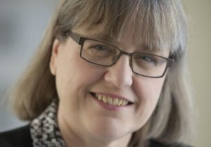

 As I wrote in my September 2018 column, the AAG Council appointed a committee to work on improving and strengthening our AAG Meeting Conduct policies, to make our Annual Meeting a safer place. The AAG Inclusion Committee will be presenting their findings and recommendations to AAG Council to consider this fall, so we can move forward with a new plan. I am grateful to the committee, led by Dr. Lorraine Dowler, for their hard work on this. Stepwise, there are other ways we can address the issue of harassment, bullying, and bias in our community and institutions. One of the informal observations by the Inclusion Committee was that science organizations seem to be ahead of the issues in several senses. For the rest of this column, I will share some of the best practices of other organizations, and set an agenda for where we may ask the AAG Council and our membership to go next.