The Resilient Streams in the Urban Landscape of Washington, D.C.

The process of urbanization often leads to the alteration of local streams. Such alterations range from complete disappearance of streams by making them flow underground, converting them into canals, loss of their aquatic habitat, and changes in their morphology (Kang and Marston 2006; Kang 2007) . In Washington, D.C. many streams and springs have disappeared during the last 200 years of urban development and federal growth (Williams 1977) . The two rivers bordering the city, the Potomac and Anacostia rivers, and the National Mall within the city, look very different as compared to their respective landscape characteristics in the 1700s due to changing sediment and runoff volumes. In Figure 1 you can see that the current stream density within the city and the surrounding areas reveals a significant difference (Figure 1). However, some times the local conditions of streams are resilient enough to counter the effects of the urban runoff (Kang 2007; Kang and Marston 2006).

Figure 1: A Visual Depiction of the Current Variable Density of the Stream Network within and outside Washington DC (Source: USGS)

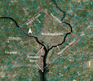
While many local streams have disappeared, the resilient Rock Creek continues to drain the western portion of the national city into the Potomac River. The prominent names among the streams that disappeared include Smith Spring, Frankling Park Springs, Gibson’s Spring, Caffrey’s Spring, City Spring, and Tiber Spring (Williams 1977) . While some of them are underground, others were converted into canals or significantly reduced in their coverage for the development of the city. However, Rock Creek has successfully survived through the impervious development of the city.

Despite ambitious urban growth, the federal government protected the Rock Creek Park so that Rock Creek could meander through its flood plain. It is also a vibrant ecosystem supporting aquatic life as well as wildlife in its flood plain. One of the cherished experiences of many Washingtonians is to witness a rich variety of wild life as they conclude their late evening commute from work through the Rock Creek Parkway that partially runs through the flood plains of Rock Creek.

Figure 2: Location of Klingle Creek in Washington, D.C. (Source: USGS)

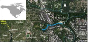
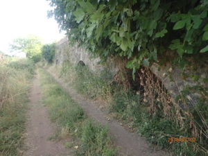
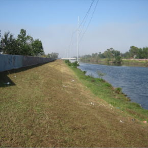
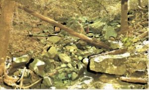
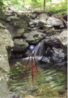
The successful survival of Rock Creek during the last century of urban growth is also because of its equally resilient tributaries that kept it alive and strong. Tributaries such as Klingle Creek (Figure 2), offer a microcosm to understand the resilient structure and ecology of this national creek. Klingle Creek is a small urban branch of Rock Creek and flows through the neighborhoods of Woodley Park, Cleveland Park, and Mount Pleasant in the city of Washington. It is unique to Rock Creek because of its geomorphic survival during the changing land cover politics around it. Surrounded by highly urbanized landscape, Klingle Creek presents a healthy ecosystem with a variety of fluvial processes. The stream has adjusted to the surrounding highly impervious landscape in a synergistic fashion. Starting as a narrow channel at the headwater, its capacity gradually increases in the downstream direction to accommodate the urban run-off. Various sections in the upstream portion of Klingle Creek experience bank erosion allowing for a sediment supply for the lower portion. The lower portion of the creek includes large rocks creating beautiful waterfalls (Figure 3) while reducing the velocity of the urban flow. It also provides sediment traps for various types of aquatic habitat (Figure 4). Many portions of the creek present lush moss covered rocks and woody debris offering a soothing experience to nature lovers.

Figure 3: Large rocks creating a waterfall in the lower portion of Klingle Creek (Source: Ranbir Kang, 2015)
Figure 4: A medium resolution point cloud (draped with colors from orthoimages) showing the sorting of large rocks in the lower portion of Klingle Creek to trap sediment (Source: Ranbir Kang, 2015)

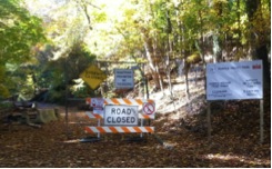
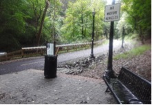
Despite a highly urban landscape comprising its watershed, Klingle Creek is lined by a riparian corridor with a thick tree canopy. While the occasional tree fall offers woody debris to regulate the eco-geomorphology of the stream, a thick tree canopy helps promote the interception of rainwater. Therefore, it has played an important role in the survival of Rock Creek against the urban sprawl in the heart of our capital. For a long time, Klingle road (which ran parallel to Klingle Creek) was used by locals as a quick access between Cortland Place and Porter Street. However, the frequent flooding and maintenance costs of the road made the city think about alternatives to the road which led to the calls for saving Klingle Valley. While various groups of the community gathered support to remove the road, other groups gathered in favor of keeping the road. The battle grew until the dispute reached the City Council and in 1991, the road was barricaded (Figure 5).

Figure 5: The barricaded entrance to Klingle Road in 2015. The Creek is located on the left of the barricade while facing it. (Source: Ranbir Kang)

Figure 6: The entrance to the new multi-use Klingle Trail in 2015. The Creek is located on the left while facing the trash can. (Source: Ranbir Kang)

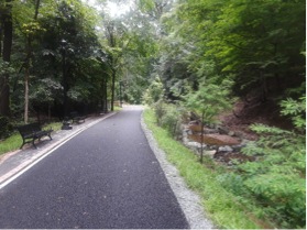
After more than two decades of dispute, in 2015 the barricaded portion of Klingle Road was replaced by a multi-use trail (Figure 6). The trail offers a variety of recreational opportunities for users of all age groups. One side of the new trail is bordered by Klingle Creek and the other side includes the historical woodland garden of the Tregaron Conservancy. While benches along the trail offer a view of the creek (Figure 7), the trail also connects the recreational communities of two neighborhoods in the city.

Figure 7: Benches along the new Klingle Trail to enjoy the view of the Klingle Creek. (Source: Ranbir Kang)

Figure 8: Post restoration use of a matting to protect the stream banks of the restored portion of Klingle Creek. (Source: Ranbir Kang)
 

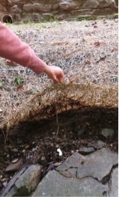
The process of replacing the road with a trail included restoring various sections of Klingle Creek through alterations of the stream banks and creating a sequence of steps and pools along the stream. It also included efforts to modify the banks by planting native vegetation and covering various portions of the bank with protective matting (Figure 8)..

The replacement of the road with a trail along Klingle Creek is an example of geodesign. There are numerous cases of urban areas across the globe where communities and city officials worked together in geodesigning their cities with a sustainable futuristic approach (Beatley 2016). The high line project in New York City and the urban parks in the city of Singapore are just two more examples where cities introduced green zones within the highly urbanized landscapes to connect their communities with nature using softer sustainable architectural designs. Economics is often one of the major driving forces behind such conservation and restoration initiatives so that the long term future demands are met with minimal cost. The ecological challenges and experiences of residents in Klingle Valley during the next decade will determine the effects of the restored creek on the larger Rock Creek, the role and functions of the new trail, and the appropriateness of restoration design and expenditures in the Klingle Valley restoration project. Klingle Valley, an urban creek along with its sister tributaries of Rock Creek offer us a soothing experience and a quick get away from the urban stress. With Washington moving forward as a sustainable city, Klingle Creek complements that ambition as a resilient hydrology of Anthropocene.

Ranbir Kang is an associate professor at Western Illinois University. With a long term research interest in the Washington metropolitan area, he specializes in urban hydrology, human impact on fluvial systems, and high resolution river surveys.

DOI: 10.14433/2017.0044

References:

Beatley, Tim. 2016. Geodesigning nature into cities. ArcNews Winter 2016:20-21.

Kang, R. S. 2007. Effects of urbanization on channel morphology of three streams in the central redbed plains of Oklahoma, Graduate College of Oklahoma State University, Oklahoma State University, Stillwater, OK.

Kang, R. S., and R. A. Marston. 2006. Geomorphic effects of rural-to-urban land use conversion on three streams in the Central Redbed Plains of Oklahoma. Geomorphology 79:488-506.

Williams, Garnett. P. 1977. Washington D.C.’s Vanishing Springs and Waterways. Arlington, VA 22202: U. S. Geological Survey.

    Share

New Books: September 2018

Every month the AAG compiles a list of newly-published books in geography and related areas. Some are selected for review in the AAG Review of Books.

Publishers are welcome to send new volumes to the Editor-in-Chief (Kent Mathewson, Editor-in-Chief, AAG Review of BooksDepartment of Geography and Anthropology, Louisiana State University, Baton Rouge, LA 70803).

Anyone interested in reviewing these or other titles should also contact the Editor-in-Chief.

PLEASE NOTE: Due to current public health policies which have prompted the closing of most offices, we are unable to access incoming books at this time. We are working on a solution during this transition and will continue our new books processing as soon as we can. In the meantime, please feel free to peruse previous books from our archived lists.

September 2018

Across Oceans of Law: The Komagata Maru and Jurisdiction in the Time of Empireby Renisa Mawani (Duke University Press 2018)

Antarctica: Earth’s Own Ice World by Michael Carroll and Rosaly Lopes (Springer 2019)

Atmospheric Things: on the Allure of the Elemental Envelopmentby Derek P. McCormack (Duke University Press 2018)

Between the Plough and the Pick: Informal, Artisanal, and Small-Scale Mining in the Contemporary Worldby Kuntala Lahiri-Dutt (ed.) (Australian National University Press 2018)

Black Spaces: African Diaspora in Italyby Heather Merrill (Routledge 2018)

Climate Wars: What People Will Be Killed For in the 21st Century by Harald Weizer (Polity Press 2017)

Collectives in the Spanish Revolution by Gaston Leval (PM Press 2018)

Decolonizing Extinction: The work of Care in Orangutan Rehabilitationby Juno Salazar Parreñas (Duke University Press 2018)

Defiant Earth: The Fate of Humans in the Anthropocene by Clive Hamilton (Polity Press 2017)

Doreen Massey: Critical Dialogues by Marion Werner, Jamie Peck, Rebecca Lave, and Brett Christophers (Agenda Publishing 2018)

The End of the Cognitive Empire: The Coming of Age of Epistemologies of the South by Boaventura de Sousa Santos (Duke University Press 2018)

Experimental Practice: Technoscience, Alterontologies, and More-Than-Social Movementsby Dimitris Papadopoulos (Duke University Press 2018)

Fish Town: Down the Road to Louisiana’s Vanishing Fishing Communities by J. T. Blatty (University of Virginia Press 2018)

Handbook on the Geographies of Power by Mat Coleman and John Agnew (eds.) (Edward Elgar Publishing 2018)

Handbook on the Geographies of Regions and Territoriesby Anssi Paasi, John Harrison, and Martin Jones (eds.) (Edward Elgar Publishing 2018)

A History of America in 100 Mapsby Susan Schulten (University of Chicago Press 2018)

Lévi-Strauss: A Biography by Emmanuelle Loyer (Polity 2018)

Migrants and City Making: Dispossession Displacement and Urban Regenerationby Aye Çaglar and Nina Glick Schiller (Duke University Press 2018)

Performing Animals: History, Agency, Theaterby Karen Raber and Monica Mattfeld (eds.) (The Pennsylvania State University Press 2017)

The Promise of Infrastructureby Nikhil Anand, Akhil Gupta, and Hannah Appel (eds.) (Duke University Press 2018)

Rhetorics Haunting the National Mall: Displaced and Ephemeral Public Memoriesby Roger C. Aden (ed.) (Lexington Books 2018)

Rooster Town: The History of an Urban Metis Community, 1901–1961 by Evelyn Peters, Matthew Stock, and Adrian Werner (University of Manitoba Press 2018)

The Scramble for the the Poles: The Geopolitics of the Artic and Antartic by Klaus Dodds and Mark Nuttall (Polity Press 2015)

Sites Unseen: Uncovering Hidden Hazards in American Citiesby Scott Frickel and James R. Elliot (Russell Sage Foundation 2018)

Stolen City: Racial Capitalism and the Making of Winnipegby Owen Toews (ARP Books 2018)

Upstream: Trust Lands and Power on the Feather Riverby Beth Rose Middleton Manning (The University of Arizona Press 2018)

The Wake of the Whale: Hunter Societies in the Caribbean and North Atlantic by Russell Fielding (Harvard University Press 2018)

    Share

Caitlin Kontgis

Education: Ph.D. in Geography (University of Wisconsin-Madison), M.S. in Environmental Health Sciences (University of California-Berkeley), B.A. in Geography (University of California-Santa Barbara)

Describe your career path following your Ph.D. up to your current position. What are the range of tasks / responsibilities for whicyou’ve been responsible in the positions you’ve held?
I submitted my dissertation in December 2015, but I had already begun at a company called Descartes Labs, a startup that analyzes petabytes of satellite imagery. We have a team of software engineers that deals with ingesting the data, correcting it, and building a Python-based platform to access it. I’m on the Applied Science team, and we’re using the data to generate models or maps of various land cover types. Some of this is client driven; for example, a client might come to us and want to know where all of the corn in the United States is and what the yields will be at the end of the year.

We have a pretty wide variety of clients. We work with the U.S. government, and we have a particularly cool project with DARPA assessing food security in the Middle East and North Africa. We have also worked with Cargill – they’re interested in agriculture, obviously, and we also have other sorts of commodities clients. We’ve also done work with non-profits and have contacts at World Resources Institute and National Geographic.

The project that I’m currently working on involves using radar data to map rice across Asia, so it’s sort of a return to what I was doing in my Ph.D. I started at Descartes while I was still finishing my dissertation. I was looking at a lot of jobs as I was finishing, but I wasn’t really finding jobs that seemed like the right fit or where I wanted to be geographically. I Googled “private sector jobs with remote sensing” and this small company came up – the company was only 10 people at the time. I interviewed and really liked New Mexico, the people, and the team, so I decided I’d give it a shot and have really enjoyed it.

The job has evolved since I began working here. When I started it was only about a dozen people, and there wasn’t much structure on the team. Now we’ve grown to about 75 people, so we’ve had to get quite a bit of structure in place. I lead our solutions efforts; on the Applied Science team, we’ll have customers come to the Sales team and pitch an idea, and I help the Sales team assess whether or not the idea is technically feasible. We now have a proposal process in place, where we’ll do a more in-depth review of the project to see how we would approach it, roughly how much time it would take, how many people it would require, and then go from there. I lead the team that is doing all of the solutions work and then work with the Sales team to make sure we’re not committing to something we can’t do.

Can you talk a little more about the analysis you perform – you mentioned that it’s not just limited to the U.S., correct?
Yes, we have the entire historical Landsat archive, as well as global MODIS data and European Space Agency Sentinel data across the globe. When the company was just getting off the ground our initial project was trying to predict corn yields in the United States earlier in the season and with higher accuracy than the USDA, which we did, and that’s how we got our first couple of customers. From there, we’ve looked at a variety of applications including forestry, construction, and different types of agriculture across the entire globe.

The backbone of the company is the computing systems that we have. The team that started the company came from Los Alamos National Labs, and they were experts in high performance computing. They picked up on remote sensing quite easily, then built a system that can process data very efficiently so we can scale analyses really, really rapidly. I think I processed all of the data for Asia and ran that model in less than six hours for the entire continent. That’s really the powerhouse of the company.

How has your education/background in geography prepared you for this position?
I think the thing that jumps out most obviously is having a good grasp of procedural geographic knowledge. We work with spatial data and massive amounts of satellite imagery on a regular basis, so having a thorough understanding of these kinds of data is critical to what we’re doing on the job. For example, we have a project monitoring food security in the Middle East and North Africa. Ideally, we would just choose a random assortment of points and label all of them across the region to train and test our models. However, that’s not feasible given constraints on how you can move across the area. For instance, there may not be road networks, or you might be trespassing onto private land. Thinking about how to best use the data given, that it might be quite linear and not indicative of the entire region that you may want to be sampling, is very important.

I think understanding that these issues exist and being able to creatively brainstorm how to overcome them is pretty critical for what we do, as a lot of clients that we work with may not necessarily understand those concepts as thoroughly. They’ll often come to you with a vector dataset of points, and not understand why you can’t use those points right off the bat. In order to communicate that information to clients in a way that makes sense and is easy for them to understand, you need to have a pretty deep understanding of the datasets and what’s possible or isn’t possible given the constraints of the imagery that’s being collected.

How does your knowledge of the region under analysis – for example, the landscape characteristics or the cultural/economic geography of the area – inform your overall approach in how you use these technologies and how you analyze the environments?
It’s a huge component of what we do. The most obvious example I can think of is just the climate of a region. When I was working in Vietnam during my Ph.D., I was relying on Landsat data, but for six months out of the year, you don’t get a single scene where you can actually see the landscape because of the monsoons. At Descartes, it’s been much easier because we have all of the radar data from the European Space Agency on their Sentinel-1 satellite. Radar data can be difficult to work with, but in regions like the monsoonal tropics, it’s the only way you’re going to get data throughout the whole year.  Having that knowledge of where you’re actually studying and understanding those climatic impacts is crucial.

Also, there are geo-political considerations. Looking at the tariffs that are now being imposed by the United States – is China going to start sourcing all of its soybeans from Brazil now? Keeping track of that and understanding how that might affect some of the models that we’re running is critical in having a deeper understanding of the dynamics that we’re trying to study and better understand. Because some of it you can’t just explain with the satellite imagery, you have to have a broader view of what’s going on globally with politics and trade.

What have you observed in your career in terms of positive impacts in the community or for your clients? How has geography enhanced the work of your organization?
In terms of the organization, I mentioned that the company was very small when I came on and most folks on the team had a background in astrophysics or computer engineering. It was amazing and pretty humbling what they were able to do without formal training in remote sensing or geography. However, being armed with some of the knowledge that I got during my Ph.D. has been important.

Understanding the terms that people are using in more detail has also been critical. For example, if we want to map urban areas, what exactly is an urban area? We think about urban areas being San Francisco or Washington, DC or New York, but globally those are quite different and varied. In Vietnam, for example, many parts of the cities are made of vegetation, so we aren’t necessarily picking up that signal in remote sensing data the same way we would looking at San Francisco. So, bringing those ideas of geography and what constitutes a certain land cover type, or this broader picture of what the data are saying has been useful for the team. I have since recruited some of my friends out of Madison so we now have more geographers on the team, which is great, as we’re able to convey geographic concepts to the broader group. I think it just arms us better to go out and talk to other experts in the field, and better communicate with our clients as well. For the organization, I think it has been very useful to have that knowledge on the team.

In terms of our community, Santa Fe is a small town and our company is a big fish in a small pond, so we’ve been able to give back in a variety of ways. We are out and involved in the community, and everybody thinks that what we are doing is mind-blowing, so it’s fun to present our work locally. We’ve done a few presentations around town and at schools, and it’s pretty neat to watch people who have no experience or exposure to satellite imagery see what sort of things can be done with it.

When you look back at your education trajectory, how did you discover geography? How did you realize that it connects with your aspirations and your goals in life, as a private citizen, but also as a professional?
I had a really, really amazing teacher for my intro to geography course at UC Santa Barbara. I didn’t know geography was something that I could major in when I went into undergrad; I took the course to fulfill a math requirement. The course was amazing. Carl Sundbeck, the lecturer for the course, showed different images of a road trip he took in the 1970s across the entire United States. He was describing the landscape and how different mountain ranges formed, or how a city such as Los Angeles grew up where it did because of the geography of the region and why that was beneficial. Drawing these connections just sort of blew me away, and suddenly the world made sense in a way I had never thought about. And it made me want to learn about geography, obviously, so then I ended up majoring in it.

I traveled for a bit between my Bachelor’s and Master’s programs, and it was amazing making those same connections that I was making during my initial intro to geography classes. It was really exciting and made me want to continue down that path. During my Master’s degree, I was doing a lot of data processing and epidemiology work, which is very statistical and very important, but it’s just not for me. I felt stuck at my desk and not really doing the work that I wanted to be doing. I went to Vietnam the summer between the two years of my Master’s program with a friend of mine from undergrad who was from there and we stayed with her family. I felt the same way as an undergrad when I was traveling. I wanted to get back to geography and do research that was in the field, which was a lot more dynamic than what I was working on for my Master’s thesis.

I then ended up going to Madison for my Ph.D. because the woman who taught my remote sensing classes at Santa Barbara had moved there. So I went to work with her and basically went with the excuse that I wanted to continue exploring, traveling, and getting to know other cultures. I proposed to do the work in Vietnam and got it funded by NASA. I was really lucky in that regard, as I got to sort of drive my own ship. And then coming to Descartes, it just sort of continued. I’m not necessarily out in the field collecting data and interviewing farmers, but it’s still every single day looking at satellite imagery and trying to better understand the world, so it’s exploration in a different form. It’s doing a lot of exploration via satellite imagery, not necessarily boots on the ground, but it’s still fulfilling that interest.

Do you remember having an “a-ha!” moment, that perhaps changed the way you think about issues and topics? Is there another example you might have?
It definitely occurred when I was at Santa Barbara. I realized that “Wow, you can earn a living doing something that you really love!” I don’t know what I envisioned I’d be doing after college when I was 18, or what I’d be doing as a career. There was some moment at Santa Barbara when it all clicked. I remember realizing there are jobs where you can continue on a path of scientific discovery and exploration, that you don’t just have to be crunching numbers and data or doing something that’s just a job. You can do something that you really feel passionately about. You know, it probably was that first geography class, and then the same lecturer taught the follow-up class the next semester. I think at that point I was pretty hooked. At that stage, I hadn’t even taken a remote sensing class and didn’t realize what career opportunities were out there. It was just sort of like: I love this; this guy can make a living doing this, so there must be room for other people. Those first couple of classes in college were pretty crucial to where I am now.

    Share

John Sauvageau

Education: M.S. in Geo-Information Science (Salem State University), B.S. in Cartography and GIS (Salem State University)

Describe your job. What are some of the most important tasks or duties for which you are responsible?
I work within the Retail Network Transformation team, which falls under the consumer business banking umbrella. We’re responsible for the strategy and planning of our branch markets, and where we want to put branches and ATMs. We leverage GIS to analyze and visualize our internal and external data spatially. We then use the ESRI platform ArcGIS Enterprise with its various tool sets including business analyst, network analyst, and spatial analyst as the tools to help us develop strategy.

We provide services to much of the northeast, including Rhode Island, Massachusetts, Connecticut, New Hampshire, Vermont, New York, Pennsylvania, Delaware, and Virginia, and also parts of the midwest like Ohio and Michigan.  We’re responsible for supporting the analysis and branch recommendations for all types of branch actions – open, close and relocations.

How has your education/background in geography prepared you for this position?
Grasping the various levels of geography and how they relate to each other is fairly important to understand. The banking industry is a little bit different than a standard retail industry, where chains can just put a store where there’s going to be high traffic. We deal with varying levels of governmental compliance. One aspect of compliance is proportionately locating branches in areas to ensure we are serving low to moderate income households, as well as middle to upper income households. We use internal and external data, including Census data,  to understand where that population is so we can target those areas.

Looking at the five themes of geography, I think we really touch two of those: location and region. Location – we have a network of branches and locations, we monitor other retail marketplaces, where they’re coming up, where they’re going away; other competitors’ locations, where customers are located. Location really is the number one thing that I think applies to what we do in this kind of planning. It’s kind of the same thing as real estate: location, location, location, everything is location.

At the regional scale we look at how everything works together and the nuances from region to region. We designate our own regions for organizational hierarchy purposes, but states, counties, etc. – they all have unique nuances, and we want to understand these so we can better interact with the population within those regions and be in the places where they are going to be. We also need to understand how they use the banks: are they primarily driven by branch visits, or using a more digital approach with online and mobile banking? How do we customize the look and feel from region to region to make our banks more attractive?

How does your geography knowledge inform your use of GIS and make it possible to get the most out of the business analyst software and work with big data?
Many of my colleagues across the industry come from more of a business intelligence background. Many have used GIS as a next step and have gone back to universities and vendors for formal training. These colleagues are amazing and have a great deal of hands-on experience and have been using these platforms for a long time. With my educational GIS & Cartography and Geo-Information Science background as a whole, I am able to bring in and apply more foundational concepts and tools to enhance our analysis. Maps can tend to be more mass produced and less of a cartographic product, but whenever I’m asked to make a map, I try to ask more questions first. Questions like: What is the purpose? What is it that you’re trying to convey? How will you be using and presenting the map? These and similar questions allow me to create a product that will be visually pleasing to the customer and their audience and allow the map to speak for itself. Different approaches and techniques will apply for varying levels of requests; it’s not always a “one size fits all” approach.

How did you discover geography was going to help you pursue your aspirations, professionally or in your personal life?
When I think of my “a-ha moment” I always refer back to a certain exercise with ArcGIS in one of my undergraduate courses, where we were working for a town searching for a site for a new fire station. We were given criteria where it had to have its own land within a certain square footage, and it couldn’t be within 7 minutes of another fire station’s service area. Taking all of that information, creating multiple layers and using a raster analysis to find out where the best possible areas were for this fire station – I had never seen that before, so I was like “wow, this is interesting!”

I was working at a bank at that time as a part time teller and thought “this would be really interesting to bring into the bank and use GIS to figure out where to put banks.” Being naïve as I was, I didn’t understand that it had already been going on. I didn’t know it existed. It wasn’t until a few years after that where I was taking some courses at the bank, learning about processes of improvement, efficiency and those sorts of concepts where I realized how interesting this was, and that I already had a good foundation for that kind of work from my education in GIS.

My branch manager at the time gave me the best advice I had ever received for this. He said: “Look in the organization, try to find somebody doing what you want to do, and just reach out to them and ask if you can talk to them and get advice on: How did you get over here, and what kind of preparation would I need to get into this kind of area within the organization?” So I did that. I identified the person I needed to talk to, reached out to them and we exchanged a few emails. Nine months later and I got an email from another person who he referred me to, and they had just created this GIS Analyst position within the bank to do exactly what I had been looking to do in branch site location. They asked me to interview for it, and a few months later I started on this path, which leads me here today. It all goes back to that one lesson in my undergraduate that kind of sparked my interest in the field, and without that I probably wouldn’t be here.

What attracted you to the banking industry? How did you initially develop that interest?
I had just returned from being deployed – I went to Afghanistan in 2010. I was looking for some part time work. My father-in-law had been working in the banking industry for a long time and thought it would be a great fit for me as a part time job.  A branch close to home was hiring, so I applied for a part time position as a teller. I began to thrive and before long I ended up becoming a supervisor. A few years later I was  promoted to a financial services representative. While I was gaining all of this financial experience, I was also going to school full time for GIS.  I had this passion for banking and this passion for GIS and I wondered, how great would it be if I could combine them?

I started in 2014 working on the real estate team and market planning, and gained a great deal of job experience in my first year. I transitioned to another financial institution performing similar tasks. I spent the last 3 years there, and now I’m taking a more senior role at a new institution. It’s been amazing, and it’s interesting because a lot of these types of decisions don’t require banking experience. It’s a unique combination of having worked in a branch and having the GIS experience that gave me insight into how the branch operates, while many of my peers don’t have the same understanding of what it’s like to work in a branch. When I’m helping to program details like how many desks we want to design in a certain branch with a certain amount of staffing, I’m able to bring a different perspective, because I’ve been in their seats before.

    Share

AAG Welcomes Zan Dodson, Director, Program Management & Research

The AAG welcomes Zan Dodson as Director, Program Management & Research. Prior to the AAG, he was a postdoctoral associate for three years in the Public Health Dynamics Laboratory at the University of Pittsburgh and Adjunct Faculty at Carnegie Mellon University. He has taught numerous courses in geography ranging from cultural and regional geography, to qualitative methods, to GIS and remote sensing, and has served as both an undergraduate and graduate advisor.

Zan completed his undergraduate and graduate work at the University of Maryland, College Park, receiving a B.S. in Agricultural & Resource Economics, with minors in GIS and Mandarin, and a Ph.D. in Geographical Sciences. For his dissertation research, Zan used mixed methods to better understand the complex relationship between chronically-ill subsistence farmers in Mozambique, food insecurity, and how access to health care could be improved. More recently, he has focused his efforts on using open data to examine spatiotemporal patterns in opioid use disorder and optimizing health care accessibility, as well as developing new approaches for measuring social determinants of health. Zan also has significant work experience outside of academia, working thirteen years for Merriweather Post Pavilion where he served as an Operations Manager.

Zan will be working on the AAG research program and with the AAG management team to support the Association. He is currently working with the AAG team and researchers around the world to expand the International Geospatial Health Research Network (IGHRN), which explores new research frontiers in geospatial health and to generate research synergies through international networks to share data and information. He will also help support the AAG research team on a newly-funded NSF award that will develop a geospatial virtual data enclave where researchers can work securely with confidential geospatial data.

When not working, Zan enjoys hiking, cooking—especially, working on his sourdough—and spending time with his kids. He also dabbles in photography, painting, and playing guitar.

    Share

Postcards from the Mediterranean: Groundwater, Glaciers, and Geoparks

Article 15 and the Human Right to Benefit from Science

One of the enduring themes for AAG Annual Meetings is Geography, Science, and Human Rights. We will continue to incorporate this nexus of human and physical geography, and GIScience, into the 2019 AAG annual meeting as a major theme. Understanding and teaching the right to benefit from science is more important now than ever. We inhabit a world of political uncertainty but growing scientific certainty, a time where the U.S. Endangered Species Act is currently under attack, and a planet where coastal villages are threatened by icebergs from Glaciers breaking up due to global warming, at the same time that communities ranging from Athens Greece to Yosemite and Redding, California are ravaged by fires stoked by record summer heat.

Article 15 of the International Covenant on Economic, Social and Cultural Rights requires states to: “recognize the right of everyone to enjoy the benefits of scientific progress and its applications; conserve, develop, and diffuse science; respect the freedom indispensable for scientific research, and recognize the benefits of international contacts and co-operation in the scientific field.”

These principles embed scientific benefits and freedom within economic, social, and cultural rights. Only 4 of 163 nations have not ratified Article 15 thus far, and the U.S. is one of the 4. The more we can educate our students and future leaders about this fundamental right, the stronger our communities and healthier our environment, and the future, can become. In addition to arming ourselves with knowledge, taking geographical action can shape our future. Contributions by geographers include mapping and documenting social and environmental changes through space and time; explaining their origins, processes and human interactions; and proposing potential solutions to stem the damage to our planet and its future. Several overlapping fields of environmental history, historical ecology, and biogeography presents us with the long view of human interactions with a changing planet, and insight into societal response and responsibility in global environmental change. We can promote Article 15 by coupling a linked understanding of the enduring benefits of Cultural and Natural Heritage Resources, a natural partnership for human geographers, physical geographers, and GIScientists.

Cultural and Natural Heritage: Aqueducts and Antiquities in Italy

This water supply anchored in antiquity still leads to Rome, July 2018. Photo by Sheryl Luzzadder-Beach


Geoparks and World Heritage sites offer insights into natural wonders and past human environmental interactions and innovations. Ancient Rome drew its waters from the surrounding countryside, including groundwater springs emanating around nearby caldera lakes. Groundwater is the second largest storehouse of fresh water on earth after glacial ice. What links groundwater, glaciers, and geoparks is that all contain ecofacts of the past. The water in a groundwater aquifer or in a glacier may take millennia to cycle through. Field research this July took our team to the headwaters of those ancient Roman springs, and to a little-known link to the modern world: Roman aqueducts still deliver spring water to the modern city of Rome. Under storm drain lids and behind locked gates, springs provide fresh water for millions of people. One of the water managers of those springs told us, however, that the groundwater production is lower this year, as observed in one of the several nearly empty cisterns our team visited in July. Like California, this is a symptom of drier, hotter summers and increasing water demands on the aquifers, overtaking their recharge. Imagine a water delivery system in place since Imperial Rome that now is becoming inadequate. Ancient aqueducts are outdoor museums as well as lifelines for the modern community, and an enduring lesson in hydroengineering. We will continue researching this site as part of the Water Stories section of UT Austin’s Planet Texas 2050 Research project, providing relevance to modern cities and agriculture in increasingly thirsty regions.

Central Sicily, July 2018. Photo by Sheryl Luzzadder-Beach

About 500 km south of Rome, the Ancient Greek city of Morgantina, a UNESCO World Heritage Geopark in Sicily, provides both modern ecotourism and a window on past societies. Morgantina also drew upon springs and water systems more like qanats than aqueducts for its water supply, as does the contemporary city of Aidone near the ancient city. Though ancient Morgantina’s architectural wonders have persisted, its surrounding Sicilian watersheds are choked with eroded sediment, over 2 meters in a few decades judging by the modern sneaker found embedded in a stream cutbank this summer. Erosion events regularly cover modern highways with sediment, and strip farmland of top soil, frittering away Saharan dust and Etna ash. In the face of the bimodal Mediterranean climate regime of hot and dry summers followed by winter rain and mudslides, too few of Sicily’s modern farmers have incorporated water and soil conservation to save their rationed water, using drip irrigation systems in orchards and vineyards, and contour plowing for dryland grain crops. A modern dam blocks the once free flowing Gornalunga River, forming the reservoir Lago di Ogliastro, to provide water to the region. Abandoned farmhouses dot the landscape, indicating the latest boom and bust cycle on this semi-arid island in the ancient Middle Sea. Urban Aidone, like so many Mediterranean places, experiences water rationing and dwindling cisterns.

Melting Glaciers, Mount Blanc, and Changing Ecosystems

Mer de Glac, France, July 2018. Photo by Sheryl Luzzadder-Beach

Recent research by NOAA, EPA, and the National Park Service has documented “early spring” affecting ecosystems around the country, especially in the northern continental U.S. For example, Washington, D.C.’s famous cherry blossoms have a long-term trend of peak bloom 5 days earlier over the last 90 years. The timing of leaf emergence and blooms, and cycles of wildlife and pollinators have become out of sync in places due to changing seasonality linked with global warming. Researchers in Rocky Mountains National Park have been following the early spring cycles impacts on Alpine ecosystems and wildlife adaptability, as documented recently by National Public Radio. In addition to supporting the ecosystems of alpine zones, Glacial Ice (in ice caps and mountains) is the largest storehouse of fresh water on Earth. I had the rare opportunity to do alpine zone field work this July with a first-year Geography Ph.D. student in the French Alps, hiking along the snow line and moraines near Mt. Blanc to examine emerging ecosystems and their services in the wake of glacial retreat. Since most glaciers around the world are retreating, there is no shortage of study sites.

Yosemite is Burning

John Muir wrote, “When we try to pick out anything by itself, we find it hitched to everything else in the Universe.” Slope stabilization links to the integrity of mountain geomorphic systems, hydrologic and ecological systems, and to human communities and livelihoods (see: R. Marston, Annals 2008, 98:507-520). In the wake of the current California wildfires, including Muir’s beloved Yosemite, mudslides and more human tragedy will likely follow. As science is a human endeavor hitched to human rights, it is a privilege to share our work, to ensure its broader impacts, and to create an environment in which geographical research may thrive and benefit the world through new knowledge and effective policy.

Another major theme that holds these places together is refugees, and France and Italy have shared in this global phenomenon.  In Aidone, migrants are a growing portion of the population, just like the ancient Greek migrants were 2,500 years ago. Whether studying climate refugees, or migrants fleeing conflict, Geographers have so much to contribute to the intersections of environmental justice and human rights.

A Geography meeting featuring that intersection is the 2018 Race, Ethnicity, and Place Conference hosted by Texas State University and the University of Texas at Austin, October 23-26, 2018 in Austin. The REP Conference organizers call for original papers, paper sessions and panel submissions that further scholarship relating to race, ethnicity, and place. The theme of the 2018 REP conference, Engaged Scholarship: Fostering Civil and Human Rights, encourages geographic scholarship related to civil and human rights issues that intersect with race, ethnicity, diversity and/or social/environmental justice. Submissions are due by August 24th.

Finally, be ready to share your Geography at the Annual Meeting of the American Association of Geographers April 3-7, 2019, in Washington, D.C. We look forward to seeing you there!

Please share your ideas with me via email: slbeach [at] austin [dot] utexas [dot] edu

— Sheryl Luzzadder-Beach
President, American Association of Geographers
Professor and Chair, Geography and the Environment, The University of Texas at Austin

DOI: 10.14433/2017.0039


    Share

Patrick Shabram

EducationM.A. in Geography (San Jose State University), B.A. in Geography (University of Colorado Boulder)

What attracted you to a career in education?
I’ve spent a number of years working in private industry, yet early on began to teach part-time as an adjunct. I had spent several years teaching on the side before realizing that it is my passion. At age 42, I made the switch to full-time.

How has your education/background in geography prepared you for your teaching career?
Typically, a Master’s degree is needed to teach at a community college, along with teaching experience. Many of my colleagues have Ph.D.’s, but education is not sufficient for a position like this; without classroom experience, getting a full-time position is nearly impossible. Starting off as an adjunct or teaching as a graduate student is necessary. Personally, I brought experience from my consulting and research work in the private industry, which I believe improved my chances of securing my full-time position.

What do you do in the wine industry?
The federal government has a system in place for recognizing unique regions for viticulture, both to serve as a benefit for consumers and to protect geographic names in the industry. If a winemaker wants to use one of these geographic names on their label, 85% of the grapes used to make the wine needs to come from within the boundaries of that region (e.g., Napa Valley or Russian River Valley). To establish an area as a unique American viticultural area (AVA), a petition to the Alcohol and Tobacco Tax and Trade Bureau (TTB) is necessary. These petitions require details that identify why the area is geographically unique as a winegrowing region, as well as identify boundaries that best encompass these characteristics. I do studies that look at climate, soils, topography, viticulture and viticultural practices, and other aspects of the area to determine what makes the area unique (or determine if the area does not meet TTB requirements) and recommend boundaries. The findings are often used by growers, wineries, or grower associations to support petitions for new AVAs or to modify the boundaries of existing AVAs.

What geographic skills and information do you use most often in your work? What general skills and information do you use most often in your work?
I teach several different classes, but since I most commonly teach introductory physical geography, a well-rounded knowledge of earth sciences is essential. Technical skills in GIS, Google Earth, and other applications and online resources help in creating and running laboratories. When I interact with local organizations on building and promoting internship opportunities, an understanding of careers that are out there also helps.

Writing skills should never be overlooked. There tends to be administrative work with my job requiring the ability to present written ideas clearly and concisely.  The same goes for my work in the wine industry—that work is about 40% writing.

Are there any skills or information you need for your work that you did not obtain through your academic training? If so, how/where did you obtain them?
Networking. The importance of networking was engrained in some of my employment outside academia, where I was commonly expected to attend networking events. Someone might wonder why I need to network now, since students come to me, and I don’t really need to find new business or a new job. I’ve found a lot of excellent opportunities for collaboration, however, through my contacts at other institutions. These opportunities all have been about students. I’ve worked on grants, helped students find jobs, helped solve transfer issues, learned new teaching techniques, and found interesting subject matter all through my contacts at other colleges, non-profits, and private companies.  As an example, FRCC is in the third year of a student-focused collaborative grant with an NSF facility all as a result of networking with professionals outside my college.

Do you participate in hiring, screening, or training of new employees? If so, what qualities and/or skills do you look for?
Yes, I’ve served on several hiring committees, hired an assistant for an NSF grant, and currently help hire and manage our part-time faculty. I look for student-focused candidates; the common mistake candidates make for community college positions is focusing too much on research and not on education. Unless their research is in education, candidates need to be able to put emphasis on students and classroom experiences.

What do you find most interesting/challenging/inspiring about your work?
Seeing my students’ lives change. I’ll have students get in touch with me after having left FRCC to tell me how their time here made a difference in their lives. There’s nothing more satisfying than seeing a former student graduate from the four-year college they transferred to, and to then see the kinds of great careers they go into.

What advice would you give to someone interested in a job like yours?
Get teaching experience in any way you can. Don’t just stand in front of a room and lecture, but really think about education and your pedagogy. Strive to be a great educator.

The other advice is to be geographically flexible. If you are looking to land a job in your hometown, you may be waiting a long time.

What is the occupational outlook for career opportunities in your field, esp. for geographers?
It is competitive, but not like in other disciplines. There are usually only one or two full-time geographers at a community college, and full-time faculty tend to stay, so a position at any given college doesn’t come along very often. Someone with a degree in geography tends to have a lot of good options though, so we sometimes find we are competing for the best candidates. Chances are someone looking for a full time position won’t find a job right away, but since I’ve been here, we’ve seen a number of our adjuncts take full time positions at other institutions.

    Share

Robert Stoddard

The geography community at the University of Nebraska Lincoln lost a treasured colleague when Robert H. Stoddard died on May 21, 2018 at age 89.

Stoddard was born in Auburn, Nebraska, on August 29, 1928, the son of Hugh Pettit Stoddard and Nainie Lenora Robertson Stoddard. He married Sally E. Salisbury in 1955 and had three children: Martha, Andrew, and Hugh.

He started his studies at Nebraska Wesleyan where he earned a bachelors in 1950. Stoddard then earned his master’s in 1960 at the University of Nebraska. He received his doctorate at the University of Iowa in 1966 and joined the faculty at the University of Nebraska the following year. He remained there for 40 years, until his retirement in 2006. Altogether, Stoddard has taught for more than 40 years at Nebraska Wesleyan University and the University of Nebraska-Lincoln.

Stoddard was a specialist in the Geography of Asia, publishing especially on the geographic patterns of pilgrimages and sacred sites. He put his geography into practice by travelling widely with his family throughout Asia (and beyond), including extended stays in India and China. Bob had a strong sense of social justice and a keen appreciation of the many legitimate ways to live in this diverse world. Stoddard also taught high school in India (1952-57), and was Visiting Professor at Tribhuvan University in Kathmandu, Nepal (1975-76), and the University of Columbo in Sri Lanka (1986).

Dr. Rana P.B. Singh notes that “Bob was a pioneer in the geographic study of pilgrimages. He commenced his focus on the geography of religion with a Master’s thesis on the locations of churches in a Nebraska county (1960) and a Doctoral dissertation on Hindu holy sites in India (1966). He was co-editor of Sacred Places, Sacred Spaces (1997) and the GORABS chapter in Geography at the Dawn of the 21st Century (2003). His visits to many holy places in India have included the Himalayan sites of Kedanath and Gangotri.”

In addition to much productive research, many scholarly publications (notably Field Techniques and Research Methods in Geography, 1982), and unstinting university service, he also served his local community as a member of the Lincoln-Lancaster Planning Commission (1974-78). He was also a dedicated teacher and mentor, and these qualities were recognized when the National Council for Geographic Education gave him its Distinguished Teaching Award in 1992.

A collection of essays was published in 2016 in honor of Stoddard’s years of exemplary service. A copy of “Space, Region & Society: Geographical Essays in Honor of Robert H. Stoddard” is available online at https://digitalcommons.unl.edu/zeabook/48.

    Share

Flood Control Infrastructure and ‘Political Hydrology’ along the LA-TX Gulf Coast

An intact portion of the 17th Street Canal (flooded after Hurricane Katrina). Concrete flood walls top the levees. CC by 2.5 Wikimedia Commons, by Infrogmation

The nation’s costliest natural disasters continue to be caused by flooding. Every year, with enormous personal and financial cost to U.S. citizens, floods damage crops, infrastructure, businesses, personal property and, most unfortunately, cost American lives.1 Americans are quick to forget such disasters, however, in part because they’re frequently popping up in other places. Remember the devastating flooding in south Louisiana in August 2016? It cost $10.0 billion. Other than Texans and Oklahomans, most Americans probably do not recall their floods way back in May 2015. It cost a mere $2.6 billion.1 And these are just a couple of examples. The single event we have not forgotten, thankfully, is the 2005 Hurricanes Katrina-Rita flooding of New Orleans and the Gulf Coast. It cost $153.0 billion, the most expensive flood disaster in the U.S. Of course, this was until Hurricane Harvey struck the Texas and Louisiana Gulf Coast. Cost are still being tallied, but unofficial estimates of flood damage cost associated with Hurricane Harvey range from $150 to $240 billion.

A sure way to reduce annual flood cost and protect the financial and personal livelihoods of Americans residing in flood prone regions is to strengthen America’s levees, an enormous system of flood control infrastructure.2 This means fortifying, heightening, and/or moving levees away from the river. These options, especially the latter, are in accord with “integrated flood management,” which has become the status quo in Europe.3, 4 In the Netherlands this approach is known as making “Room for the River.”4

Flood control in the U.S. is long entrenched in the paradigm of the “100-year” flood (i.e., 1 percent event), a strict probabilistic approach rooted in a decades old practice from the late 1960s that was advocated by insurance agencies and based on shaky assumptions regarding statistics, climate, and land use.5 A 100- year flood event may seem unlikely to occur during any given year, but it has a 26 percent chance of occurring in the life of a typical 30-year home mortgage. These are not favorable odds, and they’re even less favorable in view of documented historic (recorded) climate change, land use change, and land subsidence that has occurred since the 1950s.

Change had come to America, at least it seemed. With an inability of Congress to pass climate proof flood policy, action occurred at the executive branch. President Obama’s Executive Order 13690 (Establishing a Federal Flood Risk Management Standard and a Process for Further Soliciting and Considering Stakeholder Input(6), anchored with an extensive synthesis of floodplain science research, included many tenants of “integrated flood management” with similarities to those already practiced in Europe.3, 4 In particular, EO 13690 explicitly required up to date scientific climate change projections to be included in the design of flood control infrastructure as well as embracing a modern “flood risk” approach that takes into account human safety and the value of human activities (e.g., industry, property values, agriculture, etc…). This is broadly in agreement with the direction advocated by the nation’s highest body of science, the National Academies of Science. Specifically, EO 13690 provided three options for redesigning federal flood control levees, including i) utilizing the best “actionable” climate change science, ii) construct levees two or three feet higher than the elevation of the standard 100-year recurrence interval flood, or iii) design levees to the standard of a 500-year flood recurrence interval (in the Netherlands federal levees are designed to withstand flood events having a flood recurrence interval of 1,250 to 10,000 years). An additional key component of EO 13690 is that it recognizes the value of “working with nature” to reduce flood risks, which supports environmental conservation and restoration of valuable floodplain wetlands and associated ecosystem services. This is especially important along the Gulf Coast and the lower Mississippi River because the storage of flood waters on the floodplain increases nutrient sequestration, such as phosphorus and nitrogen, which are associated with the Gulf of Mexico Dead Zone, an enormous seasonally occurring area of hypoxic (oxygen poor) water off the coast of Louisiana and Texas detrimental to the shallow marine ecosystem. Thus, EO 13690 in essence represented a change from flood control to flood management. The intended move towards this “integrative” approach to flood management was not just substantial, it represented a paradigm change in the vision and mechanics of U.S. flood control that was also environmentally friendly. And, as levees are the embodiment of flood control infrastructure, implementation of EO 13690 is squarely in accord with President Trump’s stated intentions to improve the nation’s infrastructure.

Implementation of EO 13690 required stakeholders, such as states and levee boards, to develop a plan based on one of the three above approaches in coordination with federal agencies (e.g., FEMA, Federal Interagency Floodplain Management Task Force, Water Resources Council, etc.). Thus, local and state governmental institutions had several options that enabled them to alter the placement of levee systems in accord with their own priorities, such as nature preservation, agriculture, cultural heritage preservation, and urbanization.7 Implementation of EO 13690 would have seen the U.S. finally moving forward with adaptation of a modern “integrated” risk based approach to flood management that enhanced floodplain ecosystems as well as respecting up-to-date climate change that impacts flooding in America.

Predictably, EO 13690 was abruptly challenged by some stakeholders, including those who are arguably in most need of reduced flood risk. The Association of Louisiana Levee Boards (representing all levee boards within the state of Louisiana) was opposed to implementation of EO 13690. Louisiana contends that EO 13690 would adversely impact the Louisiana economy, and that it represented “social engineering.” Louisiana levee boards were also resistant to EO 13690 because it recognizes modern climate change science, to which there is skepticism. Louisiana was also concerned with EO 13690 because it could result in significant disruption of industry and populations residing within the wetlands and floodplains of the Mississippi delta. But in the Netherlands, the Dutch were able to efficiently implement their “Room for the River” plan within the Rhine delta, which has one of the densest populations in the world with exceptionally high economic activities and property values.

Nationally, the new standards of EO 13690 were welcomed by a larger swath of stakeholders, including the Association of State Floodplain Managers.8 And fortification of the nation’s levee system was also in accord with Congressional action following the 2005 flooding of New Orleans.9 Alarmingly, it was revealed that U.S. federal agencies have scant information regarding the overall integrity of America’s ~165,000 km system of flood control levees.2, 5

The new White House administration rescinded EO 13690 in a Presidential Executive Order on 15 August 2017, about two weeks prior to the devastating flooding by Hurricane Harvey of the Houston metropolitan and coastal southeast Texas and southwest Louisiana. The precipitation totals from Hurricane Harvey event had perhaps a 500-yr recurrence interval, and the cost of the flood disaster is on scale with the Hurricanes Katrina-Rita flooding along the Gulf Coast.

— Paul F. Hudson, PhD
Associate Professor
Leiden University
The Netherlands
p [dot] f [dot] hudson [at] luc [dot] leidenuniv [dot] nl

DOI: 10.14433/2017.0032

References cited:

  1. NOAA National Centers for Environmental Information (NCEI), 2016. U.S. Billion-Dollar Weather and Climate Disasters. https://www.ncdc.noaa.gov/billions/
  2. National Committee on Levee Safety, 2009. Recommendations for a National Levee Safety Program: A Report to Congress from the National Committee on Levee Safety.
  3. European Council (EC), 2007. Directive 2007/60/EC of the European Parliament and of the Council of 23 October 2007 on the Assessment and Management of Flood Risks.
  4. Delta Commission, 2016. National Water Plan 2016-2021. Ministry of Infrastructure and the Environment, Rijkswaterstaat, the Hague, the Netherlands.
  5. National Research Council (NRC), 2013. Levees and the National Flood Insurance Program: Improving Policies and Practices. Water Science and Technology Board, Division on Earth and Life Studies, National Academies Press, Washington D.C.
  6. Presidential Executive Order 13690. Establishing a Federal Flood Risk Management Standard and a Process for Further Soliciting and Considering Stakeholder Input https://obamawhitehouse.archives.gov/the-press-office/2015/01/30/executive-order-establishing-federal-flood-risk-management-standard-and-
  7. Federal Emergency Management Agency (FEMA), 2015. Revised Guidelines for Implementing Executive Order 11988, Floodplain Management. https://www.fema.gov/media- library/assets/documents/101761
  8. Association of State Floodplain Managers (ASFPM), 2015. Executive Order 13690 and the New Federal Flood Risk Management Standard Explained. ASFPM News & Views, 28 (1), February 2015.
  9. National Levee Safety Act, 2007. 121 Stat. 1288, Public Law 110-114-Nov. 8, 2007, 110th
    Share

Alfred W. Crosby

Alfred W. Crosby died peacefully at Nantucket Cottage Hospital among friends and family on March 14, 2018, after residing for two and a half years at Our Island Home. He was 87 and had lived with Parkinson’s Disease for two decades.

Born in Boston in 1931, he graduated from Harvard College in 1952 and served in the U. S. Army 1952—1955. He then earned an M.A.T. from the Harvard School of Education and a Ph.D. in history from Boston University in 1961. His first book, America, Russia, Hemp, and Napoleon, is about relations between Russia and the U.S.A. from the American Revolution through the War of 1812. He taught at Albion College, the Ohio State University, Washington State University, and the University of Texas at Austin, retiring in 1999 as Professor Emeritus of Geography, History, and American Studies. He was the recipient of many awards including three Fulbright Fellowships and a Guggenheim Fellowship. He was elected to the American Philosophical Society, the American Academy of Arts and Sciences, and the Academy of Finland and was a fellow of the John Carter Brown Library.

He was involved in the Civil Rights movement, taught Black Studies and the history of American jazz, helped to build a medical center for the United Farm Workers’ Union, and took a leadership role in anti-war demonstrations.

His interest in demography and the role of infectious disease in human history led him to write The Columbian Exchange: Biological and Cultural Consequences of 1492America’s Forgotten Pandemic (originally Epidemic and Peace 1918); and Ecological Imperialism: The Biological Expansion of Europe, 900-1900. His fascination with intellectual and technological history produced The Measure of Reality: Quantification and Western Society, 1250-1600Throwing Fire: Projectile Technology Through History; and Children of the Sun: A History of Humanity’s Unappeasable Appetite for Energy. His books have been published in Chinese, Greek, Italian, Japanese, Korean, Polish, Portuguese, Spanish, Slovene, Swedish, and Turkish translations. His work as a historian, he said, turned him from facing the past to facing the future. He lived by the maxim: What can I do today to make tomorrow better?

He was predeceased by his sister Ruth and by Anna Bienemann Crosby and Barbara Stevens Crosby. He is survived by Frances Karttunen, his wife of thirty-five years; his son Kevin and Kevin‘s wife Pamela Mieth; his daughter Carolyn and his grandchildren Allegra and Xander Crosby-Laramie; and by his stepdaughters Jaana Karttunen and Suvi Aika and their families.

There will be a memorial service and celebration of life in May. Donations in his memory can be made to the Friends of Our Island Home, Box 39, Nantucket, MA 02554; Palliative and Supportive Care of Nantucket; or Doctors Without Borders.


On the Web:

    Share