Longtime Corvallis resident Robert “Bob” Frenkel, 89, died in Portland on Feb. 20, 2017.
Bob is survived by his wife, Elizabeth “Liz” (Mills) Frenkel; son Stephen Frenkel and wife Judy Walton; and daughter Ann Frenkel and husband Gwido Zlatkes.
He was preceded in death by his sister, Janice Pachner.
Bob was born in New York City in 1927 to Leo and Helen (Wolff) Frenkel. He discovered his lifelong love for the natural world in Central Park — his backyard. He attended Kenyon College in the late 1940s. At Kenyon he survived a jump from a burning dormitory but broke so many bones he was told he’d never walk again. Undaunted, Bob recovered within a year and graduated. He went on to obtain a master’s in metallurgy from UC Berkeley, where he hiked and climbed at every opportunity throughout the Sierras and Cascades.
After working as a metallurgist at Stanford Research Institute (SRI), Bob returned to UC Berkeley in 1959 to follow a career path more closely aligned with his interest in the outdoors. He received a Ph.D. in geography, specializing in ruderal vegetation along California roadsides.
While at SRI Bob met and married Liz, who became a strong partner in his passions for mountains, hiking, environmental activism, international travel, good food and wine, music (particularly chamber music and the Oregon Bach Festival) and family.
Bob and Liz moved to Corvallis in 1965 where Bob joined the geography faculty at Oregon State. His specialty areas were biogeography and plant ecology, particularly in salt marshes. After retiring in the 1990s, he continued to conduct research as an emeritus professor.
Among Bob’s more notable achievements were his seminal work on salt marsh restoration at Oregon’s Cascade Head and his fight to protect the Jackson-Frazier Wetland north of Corvallis in Benton County. The county honored Bob by dedicating the wetland’s boardwalk — which Bob planned, raised money for and even helped build — as the “Bob Frenkel Boardwalk” in 2005.
Bob had a long history of environmental activism, particularly with the Sierra Club and The Nature Conservancy. His Sierra Club involvement began with the Mills Tower Conservation Committee, and included building and maintaining ski huts in the Sierra Nevada, becoming an active member of the Pacific Northwest Chapter, and serving as the first Chair of the Mary’s Peak Group and later as Oregon Chapter Chair.
In 1982 Bob received the Oak Leaf Award from The Nature Conservancy for his outstanding service for land conservation in Oregon, and in 1997 he received the George B. Fell Award for exceptional accomplishments from the Natural Areas Association.
Bob loved to share stories and slideshows of his adventures, from climbing Mt. Orizaba in Mexico, to a six-month bicycle trip through Europe in the early 1950s, to hikes, backpacks, ski tours, and international trips with his family. Though Bob’s memory was cruelly robbed by Alzheimer’s, these memories live on.
A memorial celebration in Corvallis is being planned for late spring.
Bruce L. Rhoads, a professor of geography and geographic information science at the University of Illinois at Urbana-Champaign, been elected a 2016 Fellow of the American Association for the Advancement of Science. He was honored “for distinguished contributions to physical geography and fluvial geomorphology, particularly for defining flow and sediment dynamics of stream confluences and river meanders.” According to his university profile, Rhoads has worked on the fluvial dynamics of streams in the Midwest for over 30 years.
Rhoads earned a bachelor’s from Shippensburg University and a master’s from Michigan State University. He completed his doctorate at Arizona State University.
Share
Post
Nina Feldman: A Career in GIS and Geography
Nina Feldman, a former intern with AAG and the Geography and Map Division of the Library of Congress, shares why she chose a career in GIS and Geography in a very poignant guest blog post for Worlds Revealed: Geography & Maps at The Library Of Congress. She discusses the family members, professors and supervisors who inspired her and helped her to discover her love for GIS and Geography. Nina is currently a senior at George Washington University, majoring in Environmental Science and Geographic Information Systems (GIS).
It has been a long, hot summer. In July, the National Aeronautics and Space Administration (NASA) released its analysis of global temperatures for the first six months of 2016. Each of these months has set a record for global temperatures. Taken together, this marks the warmest six-month period since the record began in 1880. The temperatures for the first half of 2016 were about 1.3o C warmer than the late 19th century average. This is not a trivial amount. Two weeks ago, the National Oceanic and Atmospheric Administration (NOAA) released its analysis of August 2016 temperatures and found that it marks the 16th straight month of record-breaking temperatures for the globe. California, where I am writing this, is really feeling the heat. High evapotranspiration rates have locked the state in a condition of severe to exceptional drought according to the U.S. Drought Monitor.
Global surface temperature anomalies for January – June 2016. Higher than normal temperatures in red and lower then normal temperatures in blue. Courtesy of NASA/GISS
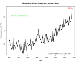
My own research focuses upon long-term climatic change. For me, anomalously warm years are to be expected as a consequence of natural variability. In the case of 2016, a strong El Niño was certainly a contributing factor to the global warmth. However, the record-breaking start of 2016 comes on the heels of a similarly record-breaking 2015 and a 21st century which has experienced 14 of the 15 warmest January-June periods on record. Looking at annual temperatures, we find that nine of the 10 warmest years on record occurred in the 21st century. What is going on? Data from Scripps – UC San Diego shows that concentrations of atmospheric CO2 at Mauna Loa, Hawaii, reached 402.24 ppm this August. This beats the August 2015 record of 399.0. This equals an additional 6.9 Gt of carbon in the atmosphere compared to last year. Values have remained above 400 ppm throughout 2016. The August 2016 concentrations continue the long-term and seeming inexorable upward trend in greenhouse gases. Politicians may debate the degree of threat posed by climate change, but it is impossible to dismiss the accumulated observations that are evidence of the large amounts of greenhouse gases we are adding to the atmosphere and the record-breaking warming we are currently experiencing. It is, in my opinion, irresponsible to ignore numerous climate-modeling experiments that indicate that a significant portion of the warming is due to anthropogenic increases in greenhouse gases and that given current emissions trends, greater warming and associated climatic changes will occur over this century. Based upon a recently published study in Environmental Research Letters of a number of surveys and literature meta-analyses, it seems that well over 90 percent of climate scientists agree with this position. There remain uncertainties in model projections of future climate, but it is notable that even well-known ‘skeptic’ Patrick Michaels wrote in a Cato Institute Working Paper in December of last year “future global warming will occur,” although he argues for a rate of warming within the lower end of projections by groups such as the Intergovernmental Panel and Climate Change.
Global mean surface temperature for the six-month period January-June from 1880-2016. The numbers are the differences from the average temperature of 1880-1899. Courtesy of NASA/GISS
Geography and geographers have played and will continue to play a large role in tackling the scientific, environmental and societal challenges posed by global climate change. Although often portrayed as aspatial trend-lines on graphs, the climatic changes being experienced today and anticipated in the future have complex and important geographies. For example, a NASA map of 2016 temperature anomalies shows greatly enhanced warming across the higher latitudes of the Northern Hemisphere. The enhanced warming of the higher latitudes of the Northern Hemisphere is consistent with climate model projections of greenhouse gas effects. Some of the more local features are not as predictable and the response of the ice sheets and ice shelves of Antarctica remains particularly problematic. At more regional scales we see features such as cooling over much of the Antarctic, but pronounced warming over the Antarctic Peninsula and Larsen Ice Shelf. A 2013 study entitled “Ice-sheet mass balance and climate change” and published in Nature by University of Sheffield geographer Edward Hanna illustrates the uncertainties in measuring, much less anticipating, the reaction of Antarctic ice to climate change. When we look at global temperature or CO2 concentrations as lines on a graph, we miss the critical geographies of climate change.
I have worked in the Arctic for many years and offer it as an example. The NASA report cited above also provides a satellite image showing one of the most prominent vegetation changes related to increasing temperatures and CO2 — the increased greening of the North American Arctic. This increase in Arctic vegetation growth has taken place as temperatures and CO2 have risen from the late 1980s through the present century. In addition, NASA reported that five of the first six months of 2016 set records for low sea-ice cover in the Arctic. Summer sea ice has now declined to the point that this August the cruise ship, Crystal Serenity, embarked on the first excursion through Canada’s Northwest Passage by a large liner. The icy waters and barren islands that claimed Sir John Franklin and all hands on the HMS Erebus and HMS Terror in the cold years of 1845-1850 have become a destination for ships holding hundreds of tourists in the hot 21st century.
The harbor at Cambridge Bay on Victoria Island in Nunavut, Canada. Will Arctic hamlets like this become regular cruise ship ports as warming continues in the 21st century? The liner Crystal Serenity, which has the capacity to carry 1,070 passengers, visited there for the first time on August 29th 2016. Photo courtesy of Glen MacDonald
At the same time, fauna such as polar bears and the culture of the indigenous Inuit people face uncertain futures in the newly warmer Arctic. As pointed out in 2006 by geographer Claire Parkinson, a scientist with NASA Goddard Space Flight Center and sea-ice remote sensing expert, in a co-authored study in the journal Arctic, polar bear responses to climate change will potentially lead to changing bear-human interactions. My colleague at UCLA Larry Smith’s recent book “2050” examines the potential climate change impacts on both environment and society in the North, including the implications of increasing ease of marine transport. These are sweeping. Paradoxically, the Arctic is one of the lowest contributors of anthropogenic greenhouse gases on earth. Increasing atmospheric CO2 concentrations is a global phenomenon, but the production of greenhouse gases is a local to regional phenomenon tied to human population, socioeconomic, industrial and technological conditions. The impacts of climate change are similarly regional and local in nature. Regions of greatest emissions are often not the regions most vulnerable to the impacts of climate change. Geography is critical to understanding both.
I would suggest three important themes that our Association and its members might consider in research and education efforts as we confront climate change in the 21st century. The first is the need for continued efforts to understand the climatic effects and other environmental impacts of increasing greenhouse gases. There is much work that remains to be done in decreasing the uncertainties that exist, particularly at finer spatial and temporal scales. At a more general level, how precipitation regimes and ocean circulation will respond to increasing greenhouse gases remains particularly problematic. The questions that arise from how plant and animal species and communities will respond are incredibly complex and in many cases understanding remains superficial. There is plenty of work for physical geographers and biogeographers. This is work that engages large numbers of us now and will continue to motivate future generations of researchers and educators.
Second, the impacts of climate change will play out in a multitude of ways on human populations and both the social sciences and humanities traditions in geography must be engaged. Mitigation of greenhouse gas emissions and socioeconomic adaptation to the impacts of climate change are complex problems. How do we maintain economic vigor, while shifting to a less carbon intense economy? How do we do so without exacerbating geographic patterns of income inequality? How can we determine the likely local to regional effects of climate change on human health, resources, economic capacity…? How can we lessen those impacts on vulnerable populations – many of which are marginal contributors to the greenhouse gas problem in the first place? In 2010, geographer Robin Mearns of the World Bank co-edited an important compendium, “Social Dimensions of Climate Change: Equity and Vulnerability in a Warming World,” that illustrates the importance and complexity of these issues.
In addition to the points raised above, there are deeper concerns at play here. How do you preserve the cultures of people, like the Inuit, which were formed in environments which are now changing dramatically? How do we preserve cultures and identities of peoples whom live on islands which may be completely lost? Tuvalu in the Pacific being one example. Even if we find answers, mitigation and adaptation require will and in many cases some sacrifice. What then drives cultures to value the environment or to feel responsible enough for other cultures and peoples to undertake altruistic actions? The humanities tradition within geography has a central part to play in tackling climate change mitigation and adaptation. In doing so the humanities can also open doors to deeper understanding of ourselves. Mike Hulme, currently professor of climate and culture in the department of geography at King’s College, has long argued for the critical role of social studies and humanities in climate change work. In 2011, Hulme wrote persuasively on this topic in the scientific journal Nature Climate Change. The article had a simple and effective title “Meet the humanities.” Indeed.
Third, we must remain cognizant that climate change, although of immense importance, is not the only challenging issue facing the environment and society in the 21st century. From land-use intensification and modification of the earth’s surface, to resource extraction, to pollution, to food security, to economic inequality, to health, to conflict, etc., there are a plethora of issues that confront us in the 21st century. Although, the impacts of any of these may be most readily manifested locally and regionally, the forces of globalization overlay all of this. In terms of these challenges and their solutions, what is local is global in many instances. Moving forward, the optimal solutions for climate change mitigation and adaptation will be those that also aid in responding to these other challenges. At the very least, our climate change strategies should not exacerbate things like economic inequality.
Meaningfully addressing the issues of climate change is not going to be easy – the winds of change we face will blow strongly and at times unpredictably. On the other hand, nowhere is the opportunity for the broad span of our discipline to work together clearer or more pressing. Climate change is one of the central challenges we face in the 21st century. Geographers have contributed much already and it is our continued responsibility to rise to this challenge. In doing so, however, we will also be rewarded with an endeavor which can serve as a powerful glue to meld the varied elements of our discipline together into a common and crucial purpose.
Join the conversation and share your thoughts on Twitter #PresidentAAG.
Those of us alive today are witnessing one of the most profound events in all of human history — and it is an event, which is fundamentally geographic in nature. The transformation we are experiencing is the concentration of the majority of the world’s population into urban areas. Although much has been made of the United Nations report that declared as of 2008 half the world’s population live in urban areas, this trend has been a long-term feature of the 20th and 21st centuries. In 1900 only about 10 percent to 15 percent of the world’s population lived in urban areas. The trend towards greater urbanization accelerated from the 1950s and shows no indication of stopping. The United Nations estimates that by 2050 some 70 percent of the world population will live in urban areas. In terms of absolute numbers that means in just 34 years there will be some 6.4 billion city dwellers.
Source: United Nations, World Urbanization Prospects, The 2007 Revision Highlights
It is not just the proportion of the world’s population living in cities that is increasing. We are also witnessing an agglomerative effect wherein the relative population size of certain cities and their metropolitan areas is increasing at a remarkable pace. This is creating a global constellation of megacities which have populations greater than 10 million. As of 2015 there were at least 35 such megacities. For comparison, in 1985 there were less than 10.
The trend of rural exodus is not confined to the developed world. Between 2007 and 2050 rural populations in the world’s less developed regions are expected to decline by 17 percent or some 440 million people. Unlike the 20th century, it is outmigration from the countryside in least developed regions that will drive the global rural exodus numbers going forward.
Although the urbanization we are witnessing is a global phenomenon it can hardly be called flat and featureless in terms of finer scale geographic detail. At present the percentage of the population living in urban areas varies greatly by country and world region. According to data from the World Bank, 82 percent of the population in North America live in urban areas. In contrast, the urban percentage in Sub Saharan Africa is 38 percent. In East Asia the percentage of urban dwellers is 57 percent, but this represents a remarkable rise from a base of 22 percent in 1960. Over that same period China has seen its percentage of urban population more than triple, from 16 percent to 56 percent. The distribution and growth of megacities also shows geographic patterning. Tokyo, with approximately 40 million people, is the world’s largest megacity. However, Shanghai and Jakarta are not far behind and growth in the latter may well make Indonesia the home of the world’s largest megacity in the near future. It is notable that eight of the 10 largest megacities are in Asia. In fact, contrasting with the relatively high proportions of urban dwellers in Europe and the United States, only a handful of megacities are found in these regions. These include Moscow, Paris, London, New York and Los Angeles. As a final point, this agglomerative process is likely to intensify in Asia and Africa as overall populations grow and rural exodus accelerates.
The trajectory towards increasing urbanization presents two sets of research challenges to geographers. The first revolves around the fundamental question of how do we classify a specific place, a population or a process as being ‘urban’? Carl Haub, senior demographer at the Population Reference Bureau, has raised this question. He points out that the U.N. focuses upon population sizes typical of larger cities. However, many people living in smaller communities may well follow a relatively urban lifestyle and consider themselves more urbanite than rural. The U.N. itself recognizes this difficulty and has no universal definition, “Because of national differences in the characteristics that distinguish urban from rural areas, the distinction between the urban and the rural population is not yet amenable to a single definition that would be applicable to all countries or, for the most part, even to the countries within a region” (U.N. Department of Economic and Social Affairs). Some of the apparent shift from rural to urban in the U.N. data reflects the growth of smaller communities to a population size that crosses the urban classification threshold in that country. In fact though, not much may have changed for the inhabitants. An alternative would be to classify livelihood as agrarian versus non-agrarian, but this too is nebulous. As geographer Michael Pacione instructs in his text, “Urban Geography: A Global Perspective,” urban can mean many things — population size and density, economic base, administrative structure, etc.
The spatial designation of one locale as urban and one place as rural is also problematic. An interesting remote sensing study published in 2009 by Annemarie Schneider of the Department of Geography at the University of Wisconsin and her co-authors grappled with this. They pointed out that multiple criteria exist to make such a distinction when classifying imagery as urban or rural. Schneider et al favored an approach of developing regional specific criteria for classifying a given locale as urban. From their analysis they concluded that only about 0.5 percent of the earth’s land area could be classified as urban. When one reflects on the large proportion of humans now occupying urban areas this is a remarkable spatial concentration of people. However, things may not be so simple. Geographer Karen Seto, now at the Yale School of Forestry and the Environment, and her colleagues in their paper, “Urban land teleconnections and sustainability,” have also grappled with how one defines urban. They point out that place-based classifications, such as those typical of remote-sensing land-use products, make an artificial dichotomy between the urban and the rural when in fact there is a continuum of land uses and very indistinct spatial boundaries. Using a processes-based perspective that appreciates this continuum and the flows that connect across it is more realistic, and would appreciably expand the land area we might consider urban.
One can imagine that as the nature of economies, telecommunications and the geographies of employment change and become less spatially limited, so too will the geographies of the urban and the urban-rural continuum. In addition, rural economies, demographies and geographies are changing. In the Unites States family farms are replaced by large corporate farms. Mechanization further decreases agricultural workforce needs. At the same time networked urbanites find affordable accommodations or space for start-ups in these increasingly available rural locales. Though agglomeration of these networked or commuting exurbanite populations increase, types of labor shift to non-agrarian and rural regions become increasingly urbanized in function if not in physical form. The hinterlands surrounding the San Francisco Bay Area are an example. At the same time, the inner city cores which experienced depressed real estate markets due to the flight of upper and middle classes and manufacturing are being redeveloped and gentrified in many cities. This in turn is pulling people back to denser urban cores.
Cairo, Egypt, is one of the world’s megacities with a population estimated to be around 20 million people. (Photo courtesy Glen M. MacDonald)
Geographers have a major role in studying and determining how the term urban is defined. In this case the focus will need to be both on the spatial and the process-oriented perspectives. Considering the paragraph above we might ask what is the comparative experience in the new Asian megacities in terms of spatial form and processes that link urban populations? Will the patterns of urban evolution experienced in more developed countries also occur in less developed countries? Geographers have been at the lead of considering such questions. Karen Seto’s work is one recent example. We might also consider work in the tradition of the late Neil Smith as represented in his 2002 paper, “New Globalism, New Urbanism: Gentrification as Global Urban Strategy.” In it he not only spoke about the global spread of the gentrification, but also provided a much wider take on globalization, urbanism and the rise of the Asian, South American and African megacities.
The second set of questions in geography’s wheel house concern the socioeconomic, cultural and environmental implications of increasing urbanization and the growth of global megacities. Here geographers have been at the forefront. Work spans from the quantitative study of regional economic geography and the agglomerative process of urban growth to the qualitative analysis of how ethnicity, gender of sexual orientation shape individual experiences and perceptions of urban space and place. Geographers such as Michael Dear, Allen Scott, Edward Soja, Michael Storper and Jennifer Wolch of the Los Angeles School of Urbanism have had global impact through their work on the functioning and increasing economic, social and cultural dominance of the world’s global cities. The rise of Critical GIS, which directly links geography’s growing technical capacity for spatial analysis with social theory and qualitative methods is a newer and particularly exciting development. Geographer Mae-Po Kwan and her students have been recognized leaders in these efforts. Here is an approach that can provide new insights not just on the geographies within cities, but also help come to terms with the spatial and functional complexity of the urban-rural continuum.
Geographers have, to their credit, been aware that we are not just studying regression models and pixels, but the lives and futures of real people. There is the deep vein of social awareness and advocacy that permeates much of the work of urban geographers. David Harvey, who arguably stands as the preeminent urban social theorist of our time, has led the way to a melding of scholarship and social responsibility. For over 40 years, starting with the seminal work “Social Justice in the City” and continuing with a multitude of deeply reasoned works including the 2012 book, “Rebel Cities: From the Right to the City to the Urban Revolution”, Harvey and his students have set the standard for the discipline.
The relationship between urbanization and the environment in the 21st century is also critical and an area where geographers have much to contribute in terms of research and education. This matters both in terms of urban impacts on the physical and biological environment and in terms of the environmental quality for urbanites. As one of many examples of the former, a paper published this week in Nature authored by Sean Maxwell, a Ph.D. student in the School of Geography, Planning and Environmental Management at the University of Queensland in Australia, concluded that urban development was the third greatest extinction threat to species classified as threatened or near-threatened by the International Union for Conservation of Nature and Natural Resources (IUCN) Red List. In fact, the threat to biodiversity by urbanization was found to be almost twice as great as that offered by climate change. From the study of urban heat islands, spatial patterns of air, water and soil pollutants, and health threats to the geographies of parks and outdoor recreational spaces for cities and their neighborhoods, geographers have a strong role to play in the study of urban environmental quality and urban environmental justice. In her 2000 Annals article, “Rethinking Environmental Racism: White Privilege and Urban Development in Southern California,” Laura Pulido, formerly of the University of Southern California and now a Professor of Geography at the University of Oregon, brings together the strands of environment, social justice and racism in a critical assessment of how cities can fail to serve their citizens and the geographies of such injustices. This follows the tradition in urban human geography where scholarship is combined with advocacy.
In closing I reflect upon a figure entitled “The nature of human geography” in Michael Pacione’s text, “Urban Geography: A Global Perspective” in which he has placed Urban Geography at the center of all the other sub-disciplines from Physical Geography to Social Geography to Cultural Geography, etc. This might appear to be hubris, but in the 21st century and for our discipline it is not unreasonable. With most of the world’s population arguably urbanized and this trend to continue, and with cities and megacities having such impacts on global economies, culture, politics, health, the environment, etc., urban geography is indeed of critical importance. We have had a strong tradition in this area and going forward I would hope to see that urban geography can indeed form a center of gravity which brings human and physical geographers to work as teams tackling the research, education and policy challenges that the urbanized 21st century brings. This is also an important nexus where those geography departments which are twinned with planning can build bridges and collaborations that will benefit both parties. There is a long history of urban geographers receiving training in planning or being appointed to planning departments as faculty. Let’s capitalize more on these linkages. It seems to me the AAG Annual Meeting can serve as an ideal venue to bring together human geographers, physical geographers and planners in focused sessions to share work and plot collaborations on urban issues. I wonder how our journals might also serve as catalysts? The 21st century is the world of the city, and geography can capitalize upon great traditions and great potential to help understand and improve this evolving new world. Your ideas on how the AAG can help are welcome!
Join the conversation and share your thoughts on Twitter #PresidentAAG.
Geographies of Bread and Water in the 21st Century
Geography is a big discipline, both in terms of its global purview and the wide spectrum of scholarly perspectives geographers bring to bear. We should not be shy about applying ourselves to some of the biggest and most complex problems facing the world. What could be a more critical problem then providing bread and water to support the planet’s population now and in the year 2050 when over 9 million people will depend on the finite resources of the earth for sustenance? This past month the United Nations held a High-level Political Forum on Sustainable Development and issued its first tracking report on global sustainable development. U.N. officials noted that today approximately 800 million people suffer from hunger and 2 billion face challenges of water scarcity.
Of course, the challenges of food and water scarcity are not homogenously distributed across a “flat earth.” Looking at the 2015 – Hunger Map prepared by the U.N. World Food Programme, we can see an uneven geography where undernourishment afflicts less than 5 percent of the population in North America, Europe, Australia and considerable portions of South America and Asia. In stark contrast, across large swaths of sub-Saharan Africa greater than 25 percent to 35 percent of the population are undernourished. Similarly, the world is not flat when it comes to water scarcity. The U.N. World Water Assessment Map displays a geography that contains some elements of the Hunger Map, but also some important differences. According to the U.N. World Water Assessment Programme, water scarcity also afflicts much of sub-Saharan Africa, but water scarcity also extends in a broad stroke across Northern Africa, the Near East and into southern and central Asia as well. Areas such as northern Mexico and the adjacent southwestern United States and southeastern Australia are also experiencing water scarcity.
As if the current global food and water situation is not troubling enough, the prognosis for the future indicates even more challenges ahead. In 2009, the U.N. Food and Agriculture Organization produced in a hallmark report that concluded increasing human population size coupled with economic growth, urbanization and demands for high-quality food products will result in the need for a ~70 percent increase in agricultural productivity by 2050. According to the Food and Agriculture Organization this would require some 3 billion tonnes additional cereal production each year, as well as an additional 200 million tonnes of meat production. The U.N.’s estimates on future water scarcity are also not reassuring. The World Water Assessment Programme concludes that by 2025, some 1.8 billion people will be living in areas with significant water scarcity.
The impacts of anthropogenic climate change on agricultural productivity at 2050 are not entirely clear. As an example, in a 2012 review published in Plant Physiology, David Lobell and Sharon Gourdji suggested that even under pessimistic scenarios it is unlikely that net global declines in agriculture will occur at 2050. On the other hand, a 2014 study published in Nature Climate Change by Senthold Asseng and a number of co-authors including Charles Jones of the Department of Geographical Sciences, University of Maryland and Fulu Tao of the Institute of Geographical Sciences and Natural Resources of the Chinese Academy of Sciences concluded that with each additional degree of warming, global wheat production could decline by 6 percent.
The conclusions of the U.N. World Water Assessment Programme in terms of future water scarcity are concerning. Under current climate change scenarios, it is possible that close to 50 percent of the world’s population will be living in regions experiencing high water stress as early as 2030. Although the greatest number of regions likely to be afflicted by severe water scarcity lie in sub-Saharan Africa, there is little cause for those in highly developed countries to be sanguine. The Colorado River reservoir system upon which much of the Southwest receives water and hydroelectric power is already facing unprecedented low-water stresses. A recent paper in the Bulletin of the American Meteorological Society by Julia Vano and others, including Dennis Lettenmaie, now at the UCLA Geography Department, suggests that over the 21st century the river is likely to experience decades of flow significantly lower than observed in the 20th century when the reservoir system was developed.
Wheat harvest in Gujerat, one of the top 10 wheat-producing states in India. Due to recent aridity, India may need to import some five million metric tons of wheat in 2016-17. (Photo courtesy of Glen M MacDonald)
Just as today, forecasts for the future of food and water resources indicate that regional variability will be a key feature of scarcity and a critical component in addressing global challenges. Geographers have helped lead the way in appreciation of this. Diana Liverman, now at the Department of Geography of the University of Arizona, pointed this out almost 25 years ago in her work such as that with Cynthia Rosenzweig, on “Predicted effects of climate change on agriculture: A comparison of temperate and tropical regions.” More recently, William Easterling, a geographer at Penn State, and his co-authors of the chapter “Food, Fibre, and Forest Products” in the 2007 International Program on Climate Change (IPCC) assessment provide important and clear elucidation of the spatial heterogeneity in the agricultural impacts of climate change. The food and water challenges are inherently geographical in nature and the spatial scales we need be concerned with range from the global to the national and down to the individual field. Considered from a biological and physical environmental perspective one can clearly see the role that agricultural geographers and geographical hydrologists, climatologists and pedologists can and have been playing. However, it will take more than that from our discipline.
Consider again the maps and reports that the U.N. has produced on hunger and water scarcity. If environment, in the form of climate or soils etc., were the sole determinant of hunger or water scarcity we would expect neat correspondence between food challenges and isotherms or isohyets etc., but that is not the case. Rather we see much spatial diversity in these patterns, which can be attributed to differing socioeconomic conditions. In some cases, countries with undernourishment rates of less than 5 percent, lie adjacent or close to countries with rates of more than 25 percent or greater than 35 percent. This is particularly true in Africa, but is also seen in parts of South America, Central America and Asia. Water scarcity also shows such national heterogeneity. The U.N. World Water Assessment is explicit in separating those regions, such as the American Southwest, suffering from physical water scarcity and those, such as sub-Saharan nations, suffering from economically induced water scarcity. Environment has a role in the geography of food and water scarcity, but clearly the causes arise from a more complex amalgamation of environment with socioeconomic factors.
Famine in Africa today chillingly illustrates the complexity of the food security problems we face in terms of causal factors and solutions. According to the U.N., a current climatic drought, coupled in some regions with the occurrence of damaging flood events, has placed as many as 18 million people in need of food assistance in countries such as Malawi, Lesotho, Madagascar, Mozambique, Swaziland, Zambia and Zimbabwe. At the same time, civil war in South Sudan is a major contributor to a food crisis facing almost five million people while in Nigeria the barbarity of Boko Haram terrorists is a major factor in placing over 4 million people in risk of famine. In all these countries, external food aid from global sources is a critical short-term solution to avoid mass starvation. However, the cost of this for the six other countries mentioned above will be over $500 million and is largely paid for by more developed countries beyond Africa. It is sobering to consider that in 2011 over 100 Republican congressional representatives called for the defunding of a principal contributor to such efforts, the U.S. Agency for International Development. Politics and economics far distant from crisis zones of food and water scarcity can have a huge impact. In the longer term, solutions will include locally improved agriculture and water systems, but that is not likely to completely suffice. Food transference, along with maintaining the global political and economic ability for such transfers, will remain a critical component of famine relief and the overall food and water security of the planet. Thus, solutions must also consider a global perspective in terms of the earth’s overall capacity to meet the total food and freshwater needs of over 9 billion people by 2050. This is a challenge that reaches far into the realms of economic, transportation, political, cultural and conflict geography.
There is hope that the food and water challenges we face can be surmounted as we move through the 21st century. It is important to remember that although much remains to be done, there has been remarkable progress made in terms of alleviating global famine over the past 50 years. Up until the 1970’s, great famines killed an average of 1 million people annually and this has declined to as low as 50,000 people today, according to some estimates. Similarly, since 1990, there have been improvements in access to safe drinking water in places such as sub-Saharan Africa where such access has risen from 50 percent to 60 percent of the population. Looking forward, a recent study led by Wolfram Mauser of the Department of Geography at Ludwig-Maximilians-University in Germany and published in Nature Communications estimated that with improved farm management and more efficient spatial allocation of crops, the global food biomass requirements by 2050 could be met even if there was no expansion in world cropland area.
The importance of geography and the geographical perspective in feeding and watering a world population that is climbing to some 9 million people, was recognized in the 2010 National Research Council study “Understanding the Changing Planet: Strategic Directions for the Geographical Sciences.” A chapter was devoted to “How Will We Sustainably Feed Everyone in the Coming Decade and Beyond?”. The chapter outlines the ways in which geographical research contributes to understanding and solving the global food challenges and then posits some critical research questions for geographers. I invite you to read the full chapter for further exposition and consider the research questions raised there. Here I will simply quote the concluding statement:
Sustainably feeding Earth’s population over the coming decade and beyond requires better understanding of how food systems interact with environmental change, how they are connected across regions, and how they are influenced by changing economic, political, and technological circumstances. The geographical sciences’ analysis of food production and consumption, when coupled with recent conceptual and methodological advances, can provide new insights into this critically important research arena.” (p 65).
What role then can the AAG play in furthering this strategic area of geography? We are fortunate to have many talented geographers working across a broad spectrum of the discipline who have direct or ancillary contributions to make in their research, teaching and public communication. We also have specialty groups in Geographies of Food and Agriculture and Water Resources that bring together like-minded geographers to work directly on these issues through research and education. Those working in the geographical tradition of political geography, notably the members of our Cultural and Political Ecology specialty group, have long grappled with the complex environmental and socioeconomic nexus that influences development and sustainability — particularly in the global south. This helps provide a foundation for integrated multi-perspective work. However, I think we can do more to build from this. We can further promote innovative research and educational initiatives on food and water within the dedicated specialty groups mentioned, but we must also work to build even greater linkages to other geographers and our other specialty groups to develop grand and cross-cutting initiatives that tackle the complex environmental, technological, economic, social, political and cultural nexus that is at the heart of providing bread and water for the world’s populations. In such efforts geographical information sciences and remote sensing are key skills that geography brings to bear along with the perspectives noted above. Sessions at our annual meetings and special issues in our journals that seek to tackle these truly grand questions of feeding the world from multiple, but integrated, geographical perspectives form an important pathway. Inviting experts from outside geography to our meetings and to work with us on our research and educational activities will also contribute to this goal. Finally, helping our members share their research and geographical perspectives on world food and water issues with the public, is an important contribution our association can make. The global garden and its fountains are in need of help, and we, as individual geographers and as an association are an important part of the solution.
Join the conversation and share your thoughts on Twitter #PresidentAAG or leave a comment below.
Every month the AAG compiles a list of newly-published books in geography and related areas. Some are selected for review in the AAG Review of Books.
Publishers are welcome to send new volumes to the Editor-in-Chief (Kent Mathewson, Editor-in-Chief, AAG Review of Books, Department of Geography and Anthropology, Louisiana State University, Baton Rouge, LA 70803).
Anyone interested in reviewing these or other titles should also contact the Editor-in-Chief.
Nina Feldman is a senior pursuing a B.S. in environmental studies with a minor in geographic information systems at George Washington University. Her interests include art, geography and graphic design. After graduation she wants to work for an organization where she can utilize her GIS skills to help mitigate environmental concerns and gain further experience before pursuing her M.A. in geography.
She has a love for cartography and the process of discovery, which was further sparked last year when she worked for the Smithsonian Museum of Natural History categorizing old maps into a database. She has even started her own map collection of all the places she’s visited!
In her spare time she enjoys exploring amazing outdoor locations throughout the D.C. area, including the National Arboretum and Great Falls in Virginia. She is also a member of Phi Sigma Sigma sorority and is originally from Westchester County, N.Y.
Four early-career academics presented high-quality research papers in the final of the 2016 Nystrom Competition on March 30, 2016 during a special session at the AAG Annual Meeting in San Francisco.
The Nystrom Award is an annual prize for a paper based upon a recent doctoral dissertation in geography.
In Fall 2015 the Nystrom Award Review Committee considered all the papers submitted and selected four candidates to advance to the final round of the competition.
The finalists and the papers that they presented at the Annual Meeting were:
Vena Chu, University of California, Berkeley – “Assessing southwestern Greenland ice sheet moulin distribution and formation from high resolution WorldView-1/2 remote sensing”
Kimberley Thomas, University of Pennsylvania – “Bordering non-water flows: Explaining upstream-downstream power asymmetries in the Ganges Basin”
Sharon Wilcox, University of Texas at Austin – “Murderous Jaguars, King cats, and Disappearing Tigres: Emergent Rhetoric of Conservation in the early Twentieth Century”
Peng Jia, Louisiana State University – “Delineating Hospital Service Areas Based on the Revised Huff Model”
The Committee was looking for original ideas and research that makes a potential contribution to the advancement of knowledge in a particular subfield of geography. Candidates were evaluated on the basis of the clarity and effectiveness of written style in their submitted papers, and the quality and effectiveness of their oral presentation.
After careful deliberation, Kimberley Thomas was chosen as the 2016 winner. She attended the AAG Awards Luncheon on April 2 to collect her certificate and cash prize of $1,000.
All finalists have been invited to submit their papers for consideration for publication in one of the AAG’s journals, The Professional Geographer.
This award is made from a fund established by John Warren Nystrom, who served as the AAG’s Executive Director from 1966 to 1979. Nystrom was an exceptional educator who taught geography for many years at Rhode Island College, University of Pittsburgh, George Washington University, and Florida Atlantic University. He published a number of geography textbooks and periodicals on U.S. relations with the European Community, Canada and Latin America. Beyond academia, he had a long and productive career in international relations as a senior official in the Foreign Policy Department at the U.S. Chamber of Commerce, a partner in the international relations consulting firm of Allen, Murden and Nystrom, and a Senior Fellow at The Brookings Institution. He also represented the United States at UNESCO, the United Nations’ educational, scientific, and cultural organization.
Share
Awardees
2016 AAG Dissertation Research Grants
Every year the AAG provides support for doctoral research in the form of small grants to PhD candidates of any geographic specialty. Three recipients were chosen this year from among 25 applicants and will each receive $1,000.
Clifton Barrineau from the Department of Geography at Texas A&M University is a quaternary scientist studying a large sand plain of aeolian origin in South Texas. The funds from the grant will be used for Optically Stimulated Luminescence dating of sand samples collected from soil cores. This dating will determine periods of aeolian activation across the sand plain and be used to generate a detailed landscape history of the area. An understanding of the landscape’s history can be used to predict the future response to forecast changes in climate and to mitigate negative side effects of land degradation and soil loss via desertification.
Lucia Hussey from the Department of Geography at Western University in Ontario is seeking to identify the infectious diseases that are likely to have the most severe impacts from climate change in her native Ghana. The funds from the grant will support her field research during summer 2016. Her mixed methodology includes a multi-criteria evaluation approach to prioritize climate sensitive infectious diseases, then a survey, in-depth interviews and focus groups in two ecologically and climatically different districts to assess determinants of current vulnerabilities to endemic diseases. Her findings will inform the development of adaptation measures and policies to minimize infectious disease risks due to climate change in Ghana.
Sandy Wong from the Department of Geography & Geographic Information Science at the University of Illinois at Urbana-Champaign is conducting research on the causes of low rates of employment and overall well-being among individuals who are visually impaired. The funds from the grant will be used to support her travel to and lodging at her fieldwork site in the San Francisco Bay Area. Her fieldwork will involve collecting qualitative data on individual experiences and perspectives through interviews and participant observation. Her study seeks to demonstrate that space actively creates and strengthens social processes that continue to marginalize individuals with disabilities.
The AAG Dissertation Research Grants are supported partly by the AAG and partly from the Robert D. Hodgson Memorial Ph.D. Dissertation Fund, the Paul Vouras Fund, and the Otis Paul Starkey Fund.
Share
Register for Free
Create an account to get free access to exclusive AAG content.
AAG Members get exclusive access to publications, prominent journals, unique advocacy, grant, scholarship and professional opportunities with access to industry focus communities, and event discounts, including our annual meeting.
Some content may only be accessible if you belong to specific Specialty or Affinity Groups. You can still update your membership below. You will need to go through the Join flow, but you do not need to repurchase your membership unless it is expired or about to expire.
To provide the best experiences, we use technologies like cookies to store and/or access device information. Consenting to these technologies will allow us to process data such as browsing behavior or unique IDs on this site. Not consenting or withdrawing consent, may adversely affect certain features and functions.
Functional
Always active
The technical storage or access is strictly necessary for the legitimate purpose of enabling the use of a specific service explicitly requested by the subscriber or user, or for the sole purpose of carrying out the transmission of a communication over an electronic communications network.
Preferences
The technical storage or access is necessary for the legitimate purpose of storing preferences that are not requested by the subscriber or user.
Statistics
The technical storage or access that is used exclusively for statistical purposes.The technical storage or access that is used exclusively for anonymous statistical purposes. Without a subpoena, voluntary compliance on the part of your Internet Service Provider, or additional records from a third party, information stored or retrieved for this purpose alone cannot usually be used to identify you.
Marketing
The technical storage or access is required to create user profiles to send advertising, or to track the user on a website or across several websites for similar marketing purposes.
 Nina Feldman, a former intern with AAG and the Geography and Map Division of the Library of Congress, shares why she chose a career in GIS and Geography in a very poignant guest blog post for
  It has been a long, hot summer. In July, the National Aeronautics and Space Administration (NASA) released its
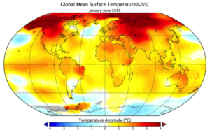

 Those of us alive today are witnessing one of the most profound events in all of human history — and it is an event, which is fundamentally geographic in nature. The transformation we are experiencing is the concentration of the majority of the world’s population into urban areas. Although much has been made of the
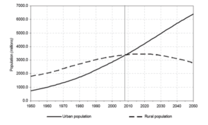
 The trend of rural exodus is not confined to the developed world. Between 2007 and 2050 rural populations in the world’s less developed regions are expected to decline by 17 percent or some 440 million people. Unlike the 20th century, it is outmigration from the countryside in least developed regions that will drive the global rural exodus numbers going forward.
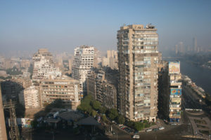
 Geography is a big discipline, both in terms of its global purview and the wide spectrum of scholarly perspectives geographers bring to bear. We should not be shy about applying ourselves to some of the biggest and most complex problems facing the world. What could be a more critical problem then providing bread and water to support the planet’s population now and in the year 2050 when over 9 million people will depend on the finite resources of the earth for sustenance? This past month the United Nations held a High-level Political Forum on Sustainable Development and issued its first
 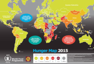 Of course, the challenges of food and water scarcity are not homogenously distributed across a “flat earth.” Looking at the 2015 –
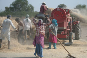
 Nina Feldman is a senior pursuing a B.S. in environmental studies with a minor in geographic information systems at George Washington University. Her interests include art, geography and graphic design. After graduation she wants to work for an organization where she can utilize her GIS skills to help mitigate environmental concerns and gain further experience before pursuing her M.A. in geography.