The AAG welcomes two new interns joining the AAG staff this fall.
Mirembe Ddumba is a junior studying Economics at Penn State University. She first became interested in geography during a Spring 2025 economic geography course, where she saw how maps and data could explain not just where things happen, but why communities grow and change the way they do. Using ArcGIS, she looked at how AI and shifts in different industries affect where people live and work, and realized that a map can sometimes tell a story better than pages of numbers. That interest led her to a Paragon Policy Fellowship, where she co-authored Charleston’s 2025–2027 flood-resilience plan and presented ideas to city leaders. She also co-created EcoGrow, a solar-powered smart farm with AI forecasting that won first place in a campus innovation challenge.
On campus, Mirembe served as Secretary of the African Student Association, planning events that highlighted culture, food, and music while building community among students. She also gained experience through an Amazon externship in workforce analytics and by attending Google’s Genesis2Genesis Student Conference, where she explored how finance and technology shape everyday decisions. Mirembe looks forward to contributing as a Media and Science Communication Intern at AAG and sharing geography in ways that are approachable and spark curiosity. In the future, she hopes to work internationally in London at the intersection of global affairs, policy, and economics, using geography as a way to better understand and address challenges around the world.
Samra McCullin is a fourth-year student at George Mason University majoring in Geography with a minor in GIS. Samra’s first introduction to the discipline was a human geography class that she took in high school, where she found passion in the intersection of social, environmental, and physical sciences. In her undergraduate coursework she is constantly surprised at how she is able to exercise both her creative and analytical strengths. The freedom of a multidisciplinary major has allowed her to explore many subgenres within geography, her favorites being tourism, transportation, and sustainable development. Following graduation in the spring, Samra intends to pursue her masters in Geographic and Cartographic Sciences, working towards a professional career in digital cartography. Samra feels lucky to have found geography as a career path so early into her academic journey and hopes that through her work as a Communities Support Intern for the AAG, she can help more people find purpose and belonging within the discipline.
If you or someone you know is interested in applying for an internship at the AAG, the AAG seeks interns on a year-round basis. More information on internships at the AAG is also available on the About Us section of the AAG website.
Share
President's Column
The War in Gaza and an Inclusive AAG Process for a Thoughtful Response
The AAG will hold a special meeting on October 3 in response to a membership petition asking the association “to endorse the BDS campaign for an academic boycott of Israeli academic institutions, and for financial disclosure and divestment of any AAG funds invested in corporations or state institutions profiting from the ongoing oppression of the Palestinian people.” Our bylaws state that if more than 10% of members sign a petition with a valid call, then the AAG will host such a special meeting. As this is a divisive issue, I write to clarify three points: 1) my personal perspective on the war in Gaza (which you deserve to know, but is irrelevant to the position of the AAG), 2) the AAG process for responding to troubling world events, and 3) some of the factors the AAG Council will need to consider before arriving at a decision on an appropriate AAG response to the situation in Gaza.
First, my own views. The situation in Gaza is deeply concerning and distressing to me personally. As some of you may know, much of my scholarship and United Nations (UN) policy work has dealt with food security and agricultural development in the Global South, often from a political ecology perspective. As per the Integrated Food Security Phase Classification (IPC) system, famine was officially declared in Gaza on August 22, 2025, confirming what many had long argued was an unfolding humanitarian crisis. It is significant and sobering that this respected and cautious UN-backed food security monitoring group concluded that all three thresholds that define a famine had been crossed. It calls the famine in Gaza “entirely man-made.” It further notes that there are “half a million people facing catastrophic conditions characterized by starvation, destitution and death.” The IPC report on Gaza comes nearly two years into an armed conflict with Israel that was triggered by the October 7, 2023 attack by Hamas. Israeli restrictions have limited the flow of food and aid into Gaza. I believe in the right to food as enshrined in the Universal Declaration of Human Rights and I stand against using food as a weapon of war. I also recognize the right of Israel to exist, condemn the October 7 attack and support a two-state solution. However, let it be clear that my own personal views matter no more than anyone else’s in our community and that the central question is whether and how the AAG might respond to this terrible situation. The AAG Council must make the best possible decision in relation to its mission and values, with the fullest possible input of our membership and according to our bylaws.
Second, what is the AAG’s process for considering a response to such a crisis? The AAG Council, the democratically elected representatives of the membership, has a legal and ethical obligation to consider actions called for in a membership petition or — in some cases — to decide how to respond to a crisis or government decision. In considering potential responses, the AAG Council must do so in a way that is in the best interest of the organization (also known as fiduciary responsibility). Typically, Council deliberations on potential actions include an analysis of relevant background information and occur without the active participation of the broader membership. However, because this deliberation was triggered by a membership petition, the AAG will engage in an open and transparent information collection process before the AAG Council arrives at a decision. The synchronous meeting of the membership on October 3 is intended to answer questions and kick-off an inclusive information collection process that provides the greatest potential for all members to participate. The process will involve a 60-day period in which any AAG member may asynchronously comment on a draft background document that will inform Council decision-making in regard to a potential AAG response to the situation in Gaza. This written comment option will be complemented by two AAG Council listening sessions (one closed session and one open to all members), both during the 60-day period. Members can sign up to share their perspectives on this matter with Council, starting on October 3. Once the background information collection period is complete, the AAG Council will deliberate on the best course of action, taking into account the concerns and perspectives of the membership as well as the mission and wellbeing of the organization.
Contrary to some views circulating, the October 3 zoom meeting will not entail an open debate among the AAG membership on the best course of action, nor a presentation by the petitioners or other groups (although this could happen in a subsequent listening session), nor a live vote of the membership. To undertake an open debate would be challenging (imagine an open zoom meeting with hundreds of members asking to speak). Furthermore, privileging some perspectives in featured presentations would be less than inclusive. Lastly, while I have received dozens of emails asking for a membership vote on the BDS proposal, this approach is not called for in our bylaws. Previous AAG membership votes have never been directly undertaken in response to a petition, but rather for an election, a bylaw change (such as the AAG name change) or on an issue at the request of the AAG Council.
Third, once the membership comment phase is complete, what types of issues might the AAG Council need to consider before arriving at a decision on an appropriate AAG response to the situation in Gaza? There are a range of potential responses, including divestment of AAG funds from organizations profiting from the oppression of the Palestinian people, an academic boycott of Israeli universities, endorsing BDS as a political movement, making a public statement about the situation in Gaza, calling for a vote of the membership on an action proposal, or no action. As noted previously, Council will need to consider all facets and nuances of these potential actions and make a decision that is consistent with the values and the well-being of the organization. In terms of our values, the AAG is committed to principles of justice, equity, diversity, and inclusion as outlined in the JEDI strategic plan and adopted by the organization in 2020. The AAG is also opposed to both Islamophobia and antisemitism, and we are dedicated to creating venues for free and open discussion of academic ideas.
While I could not possibly summarize all aspects the Council will need to consider (many of which will be in the aforementioned background document), let me just mention a couple issues that may be of interest to the membership. First, because of the work of the AAG’s climate action committee, we adopted socially responsible investment screening a few years ago. As a result, the AAG’s relatively small endowment (about 1.1% the size of my college’s endowment for example) does not have investments in the fossil fuel industry, arms manufacturing or occupied territories. Second, while the AAG could issue a statement about the situation in Gaza without violating nonprofit laws, endorsing BDS as a political movement may have complications. To wit, nonprofits, or 501(c)3 organizations, in the United States have strict restrictions on political endorsements. Furthermore, given that anti-BDS laws exist in 38 states, a BDS endorsement might inhibit our members in those states from using public funds to attend a regional or national AAG meeting. Lastly, the AAG is committed to academic freedom and we need to think carefully about any actions that might impede the free and open exchange of ideas.
In sum, the war in Gaza is deeply troubling, as were the attacks in Israel on October 7, 2023. While this issue has the potential to divide our membership, I have faith in the transparent and inclusive process that the AAG has embraced in its deliberations on the best potential response. While I understand that some of our members may be frustrated that we are debating this issue at all, or that the decision-making process is not moving quickly enough, it is important that we do this well. Healthy organizations are able to openly and fairly discuss contentious issues if they have a clear process for doing so. I am confident that our community will emerge from these deliberations stronger than ever.
Please note: The ideas expressed in the AAG President’s column are not necessarily the views of the AAG as a whole. This column is traditionally a space in which the president may talk about their views or focus during their tenure as president of AAG, or spotlight their areas of professional work. Please feel free to email the president directly at moseley@macalester.edu to enable a constructive discussion.
Sarah Praskievicz, age 39, passed away peacefully from natural causes on August 11, 2025, in Guilford County, North Carolina. Born on July 28, 1986, in Worcester County, Massachusetts, Sarah’s life was marked by a deep passion for geography and a love of travel.
Sarah’s academic journey took her from her New England roots to the Pacific Northwest, where she earned her Master’s degree in Geography from Portland State University. Her pursuit of knowledge continued at the University of Oregon, where she proudly obtained her Ph.D. in Geography in 2014. After completing her studies, Sarah embarked on a distinguished career beginning at the University of Alabama before joining the Department of Geography, Environment, and Sustainability at the University of North Carolina at Greensboro (UNCG).
Throughout her career as an Associate Professor, Sarah was deeply committed and inspiring to her students and colleagues, leaving a lasting and positive influence on all who knew her. Her dedication to education and the environment was evident in her vibrant and engaging teaching style, inspiring many young minds to explore the intricacies of the world.
Beyond her professional accomplishments, Sarah was an avid traveler who fulfilled her dream of visiting all seven continents. Her adventurous spirit and curiosity about the world around her were evident in every journey she undertook. She nurtured a profound appreciation for different cultures and landscapes, which enriched both her personal life and her academic pursuits.
Sarah is survived by her loving mother, Larrilee Praskievicz of Salem, Oregon; her father, Pauli Praskievicz of Portland, Oregon; her devoted brother, Adam Praskievicz, and cherished nephew, Seth, both of Salem, Oregon. Her family remembers her as a beloved daughter, sister, and aunt, whose warmth and kindness touched the hearts of everyone she met.
Julian Wolpert was born on December 26, 1932, to Rose and Harry (Hillel) in Brooklyn, New York. After attending Yeshiva for elementary school, Julian attended Erasmus Hall High School, where he met his future wife Eileen Selig, and graduated at the age of 16 in 1949.
Upon graduation, he enrolled at City College in New York and later transferred to Columbia University, where he received a degree in Economics in 1953. He and Eileen married in 1955, and the following year he entered Officer Training School for the U.S. Navy, as a Navigator at the rank of Lieutenant Junior Grade.
Upon separating from the Navy in 1959, Julian entered the graduate program in Geography at the University of Wisconsin in Madison, completing his Ph.D. in 1963. He then joined the faculty at Michigan State University, transferring to the University of Pennsylvania in 1965. There, he rose to the rank of full professor. In 1973, he spent a sabbatical year at the Center for Advanced Studies in the Behavioral Sciences in Palo Alto, California. The following year, he became the Bryant Professor of Geography, Public Affairs, and Urban Planning in an endowed chair at Princeton University’s School of Architecture and Urban Planning, and later was a Guggenheim Fellow at Princeton’s Woodrow Wilson School of Public and International Affairs. He retired in 2005 and remained Professor Emeritus.
Over his career studying location theory, the provision of public and nonprofit services, urban development, and environmental policy, he received numerous distinctions. He was the first Geographer elected to the National Academy of Sciences (1977), became a Fellow of the Center for Advanced Study in the Behavioral Sciences, a Guggenheim Fellow, a Russell Sage Fellow, and a member of the American Association for the Advancement of Science. He was also past Vice President and President of the Association of American Geographers, Vice President of the Regional Science Association, and was elected to the American Institute of Certified Planners. He testified before Congress and worked with various federal agencies, including the National Science Foundation, the U.S. State Department, and the National Institute of Mental Health.
He is the author of more than 100 highly significant books, journal articles, and reports. He was a pioneer in the use of computers and multivariate analysis of large data sets.
“His research and teaching always revolved around the underserved and the mobilization of resources and policies to better serve them,” recalled colleague John Seley, professor emeritus, of Earth and Environmental Sciences, Psychology, at CUNY Graduate Center.
Julian Wolpert is survived by a sister, Judith, children Seth, Jesse, Joshua, and Rebekah, and grandchildren Geoffrey, David, Jake, Samuel, Benjamin, Isabel, Lily, and Ida.
The Dismantling of Public Research Funding and the Need to Invest in a Better Future
Geographic research has improved the human condition, enhanced long-term environmental sustainability, strengthened the economy, fostered human understanding of the planet, and facilitated learning of those students engaged in the knowledge production process. While some research is funded by the private sector to specific ends, the bulk of scientific inquiry is a public good that benefits the larger society and is supported by governments whose citizenry ideally understand the long-term benefits of scientific research. While what I have presented above is the ideal, it actually works in many cases. Unfortunately, the public funding of scientific research in the United States has been willingly dismantled over the past nine months to the detriment of the academy, geography, and American society.
In 2010, the National Research Council published Understanding the changing planet: Strategic directions for the geographical sciences (written by a committee chaired by former AAG president Alec Murphy). This report set out an ambitious research agenda for the discipline, articulating big questions for geographers to tackle with significant societal impacts. Geographers in the US and around the world have aggressively worked on those questions over the past 15 years (relating to the environment, population, health, food, and migration to name a few) and arguably made the world a better place. I truly believe that a society that supports scholarly research is investing in the future and acting on the belief that we can do better. To arbitrarily defund research is to not look forward, to not have hope for a better world, and to doubt our capacity to enhance human understanding.
A society that supports scholarly research is investing in the future and acting on the belief that we can do better.”
As a fundamentally field-based discipline, geographers often need external funding to do the work we do. For example, in July I was fortunate to be in rural Tanzania with three research students and local university partners trying to better understand the food and nutrition security implications of primary schools that employ agroecological practices on their farms to produce food for their lunch programs. While our findings will hopefully have implications for the way we understand environmental sustainability, agroecology and nutrition security, just as important was the development of future scholars and international scientific exchange that was a byproduct of this process. This was a pilot project supported by seed money from my university and for which I had intended to seek external support, a prospect that now feels increasingly unlikely as the current administration has bludgeoned the National Science Foundation (NSF) and other federal agencies that support scientific research. My story is just one of many that have rippled across our discipline, cutting short the knowledge production process, the training of future scholars, and transnational scientific collaboration.
Cuts to scientific research funding in recent months have been devastating. The White House’s proposed budget for FY26 for the National Science Foundation (NSF) would reduce the agency’s budget by 55 percent, bringing its annual budget down to $3.6 billion from the $9 billion appropriated in FY2024, and a similar range of funds available in 2025. This latest proposed cut was preceded by the termination of hundreds of millions of dollars in research funding that had previously been awarded.
In February, the AAG published an open letter decrying the devastating cuts to the NSF’s Human-Environment and Geographical Sciences (HEGS) Program (while geographers have been successful obtaining grants from a number of NSF programs, this is the flagship program for the discipline). Then in early March, the AAG was one of 48 learned societies signing an open letter asking congress to protect science.
Proposed cuts to the U.S. State Department’s Fulbright Program will entirely eliminate it and in June the oversight board of this prestigious program resigned after political appointees cancelled the awards of almost 200 American professors who were scheduled to go oversees to undertake research and teaching, and put in jeopardy those of another 1200 foreign scholars who were to receive support for academic exchanges in the US.
The U.S. Department of Education has cancelled this year’s Fulbright-Hays Program that has supported the international research of U.S. professors and students for over 60 years. The loss of this program was part of a larger executive action to dismantle the U.S. Department of Education, with the AAG signing on to a joint statement against such actions in March 2025.
These are just some of the cuts to federal programs that support geographic scholarship. Of course, research costs money, and some research projects are more impactful than others, but to indiscriminately cut research funding across the broad undermines the prospect of a better future. Important advances in science are often generational in nature. Rarely do the biggest breakthroughs come in a single year, decade, or even career. Research funding is the fundamental connector that sustains research across generations. It’s not just a feel-good activity to use research funding for training future scholars: it is the lifeline of discovery, innovation, and progress.
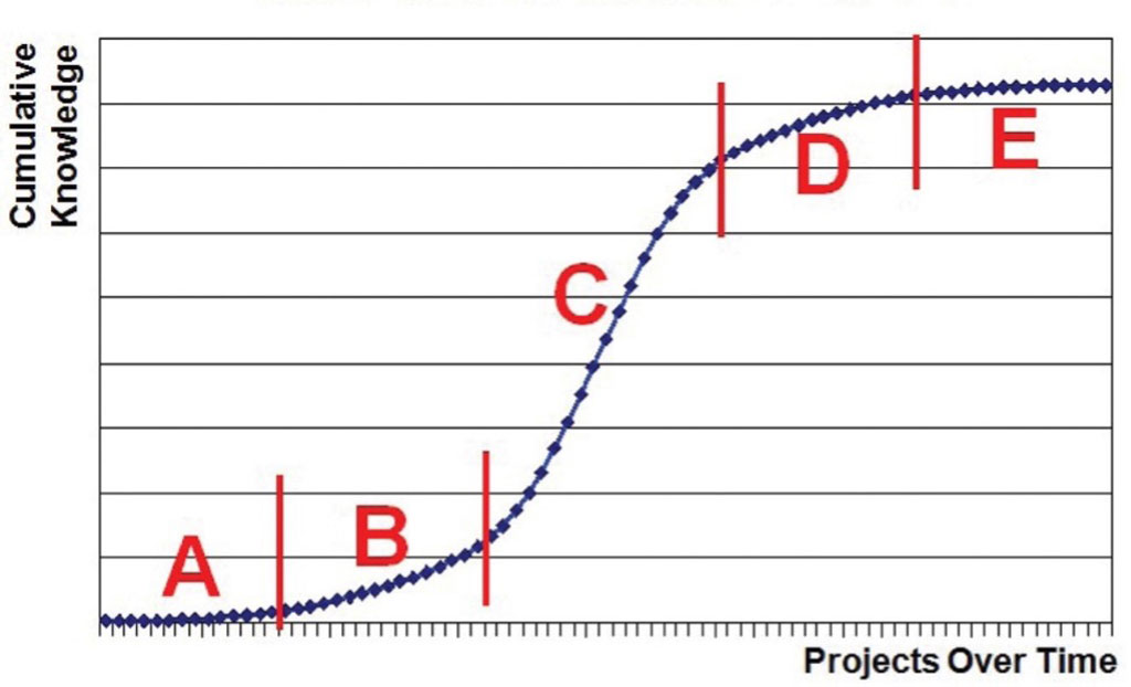
Judiciously allocated public funding is critical to the advancement of scientific understanding, to the careers of geographers and to the training of their students. Over the course of my career, for example, I have benefitted from four federal research grants, two from the NSF and two from the Fulbright-Hays Program (likely placing me somewhere in the middle of what is typical for an academic geographer). When I was younger, these grants helped launch my career and as I grew older, they helped me train future scholars. The competitive application process helped me refine my research questions and methodology, and subsequent service on several NSF panels allowed me to better understanad the care and thought that went into prioritizing which type of research to support with scarce public dollars. From my time on such panels, I still remember Tom Baerwald (former NSF Program Director and AAG past president) and colleagues showing us the research innovation S curve (or the Isserman curve), slowly starting with basic research and the trial and error search for good questions (A and B), to the steep climb and rapid innovation phase (C), to the tapering off and research saturation plateau (D and E) (see figure 1). Our task, as a scientific panel, was to identify sound projects situated at the start of the rapid innovation phase. It was an extremely rigorous process, led by panels of faculty working on a mostly pro-bono basis, and with many more good projects on offer than NSF would be able to fund.
Figure 1: The Isserman (science innovation) Curve; Source: Baerwald, T. J. (2013). The legacy of Andrew Isserman at the U.S. National Science Foundation. International Regional Science Review, 36(1), 29-35.
Geography needs to more strongly make a case for government support of knowledge production as central to a better future. Communicating the value of scientific research to broader publics is important as scholarship and universities have become targets in the US culture wars. Part of this will be about articulating a geographic research agenda for the future. What are the key questions moving forward that geographers are particularly well equipped to answer and how will geographical perspectives on those challenges help everyday people and the environment? It has been 15 years since the NRC published Understanding the changing planet. Despite the strong anti-intellectual political currents of our time, now is the moment to more forcefully articulate the value of geographic inquiry and a research agenda for a better a better future.
Please note: The ideas expressed in the AAG President’s column are not necessarily the views of the AAG as a whole. This column is traditionally a space in which the president may talk about their views or focus during their tenure as president of AAG, or spotlight their areas of professional work. Please feel free to email the president directly at moseley@macalester.edu to enable a constructive discussion.
Share
News
Financial Aspects of Running the AAG Annual Meeting
By Antoinette WinklerPrins, AAG Council Treasurer
This is the fourth of a short series of perspectives by 2024-2026 Council Treasurer Antoinette WinklerPrins–a series designed to help illuminate some of the financial challenges a professional organization such as the AAG faces. In this column, she offers perspectives on the financial aspects of running the AAG Annual Meeting. Read previous columns.
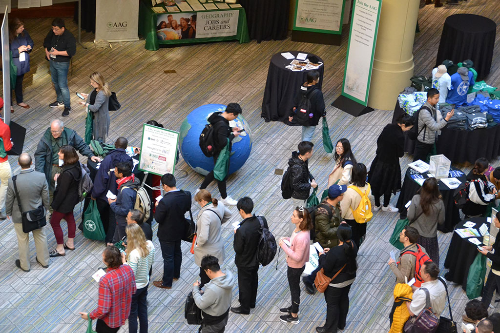
Most AAG members are aware that the AAG Annual Meeting is a key activity for the organization. In fact, for many members the annual meeting is the AAG. As a member organization, AAG provides many more services to its members all year, yet the annual meeting remains a pillar of support both for members and for the organization itself, enabling it to provide the other services throughout the year. In this Treasurer’s Corner I will share with you some perspectives on the financial aspects of the meeting.
Let’s look at three financial aspects of this most visible and vital event:
Registrationfees: Imagine you were hosting a big party but didn’t know how many people would show up? What if 10,000 might show and you might need to have 60 rooms for a week to run constant presentations? Securing those spaces without knowing who will show up is one of the many challenges (and expenses) of putting on an AAG meeting.Registration fees are critical support for the meeting – our ability to predict and secure a certain number of registrations helps us to negotiate the contract with a hotel or convention center for meeting rooms and gathering spaces, and to anticipate and cover staff costs to organize and support all the development of the programming and organization of the sessions. These activities are year-round as well as seasonal, with some building to a peak of work in the months ahead of the meeting dates, and other activities (such as venue negotiations) taking place years in advance. The current registration page states that “AAG annual meetings operate on a break-even pricing model (i.e., fees cover the cost of participation and inflation).” Note that when the AAG set new registration fees in 2023, it did not do so across the board in a “one size fits all” way. Fees for students, developing regions, under/un-employed, retired, K-12, and minority serving institution (MSI) faculty rise only very modestly, while other categories such as member and family rise moderately. The AAG chose proportional cost sharing, rather than trying to pass on all costs to members across the board, to provide the best possible value for members at a financially sustainable cost. When considering registration fees in real dollar terms, the fees had hardly changed in nearly 10 years.
Hybrid costs: AAG is one of relatively few professional organizations that remains fully committed to a synchronous hybrid annual meeting. AAG Council has made this commitment to ensure this important professional event is accessible to those who cannot travel or who make a personal choice not to travel, but who want and need to participate in the meeting. This means providing quality and stable hybrid access not just in individual presentation sessions but also live streaming plenary and other important community building events. On a larger scale, the AAG has committed to lowering the carbon footprint of its annual meetings and is on track to reduce meeting-related emissions by 45% by 2030. But running a fully hybrid meeting incurs substantial labor and IT tech support. In a previous column, I provided details on the costs of running hybrid meetings. While these costs are a financial burden, the AAG believes that hybrid meetings are a must for its members, and this is why it is necessary to charge a fee for virtual attendees that covers at least half of the costs incurred in providing the online access. While AAG has lost money on the virtual portion of the last three meetings, it believes that hybrid meetings are a must for its members, and why it remains committed to offering the service at a low fee.
Lodging choices: In a previous column, I discussed why it is important to choose your lodging at the conference hotel. Not only is it convenient and maximizes your ability to network with colleagues, but it helps AAG meet contractual obligations (usually arranged years in advance) to guarantee a minimum spent on lodging as well as food and beverage at the hotel by attendees. The next three AAG Annual Meetings (San Francisco, New York, Chicago) are all hotel-based meetings (meaning that the meeting rooms are at the hotel), not convention center meetings as both Detroit and Honolulu were, so this is very important for the financial viability of the meeting.
In its choice of location, lodging, and other offerings, AAG works to provide the best possible options to its members. We know that you have many influences on your decisions on whether and when to register, and what lodging to select for the annual meeting. We hope you can join us at the annual meeting, and that you are able to select the lodging that works the best. Please feel free to reach out to me or Gary Langham, AAG’s Executive Director, with questions, comments, or concerns. Send your comments and questions with the subject line “Treasurer’s Corner” to helloword@aag.org.
Share
Perspectives
Navigating Human Dynamics—Reflections on Chairing the AAG Symposium on Environmental Exposure, Mobility, and Health
By Michaelmary Chukwu
At the 2025 AAG Annual Meeting in Detroit, I had the incredible opportunity of serving as both a session chair and presenter for the 11th Symposium on Human Dynamics Research. This year’s symposium, themed “Human Dynamics and GeoAI,” marked a major evolution of geographic thought—building on a decade of intellectual contributions that have redefined how we understand human-environment interactions in increasingly multifaceted physical and virtual worlds. Thanks to Dr Xinyue Ye, Department of Landscape Architecture and Urban Planning, Texas A&M University and Dr Xiao Huang, Department of Environmental Sciences, Emory University, for allowing me to take up such a monumental adventure—one that has shaped my experience of AAG for the better.
The symposium’s foundation was engrained in a timely recognition: that contemporary human experiences of space and place are no longer limited to traditional geographies with which we already are familiar. Rather, spatial experiences now unravel across hybrid realms shaped by technologies such as the metaverse and fediverse, generative AI, and quantum computing—although these are relatively novel to me. As spatial researchers, we are often challenged—and empowered—to adapt our conceptual and analytical designs to this convergence. The sessions I chaired brought together a diverse group of scholars exploring how dynamic environmental exposures, shifting mobility patterns, and evolving health outcomes intersect in this digitally augmented landscape. Collectively, these sessions illuminated the role of GeoAI as both a lens and a tool for addressing these multifaceted challenges. My aim in this article is to reflect on my experience facilitating and participating in these sessions, highlighting key themes, emerging insights, and the broader significance of human-centered, technologically informed geography in an era of rapid transformation.
A Broad Shift in the Discipline
The field of human dynamics has always been centered on the spatial understanding of how people interact with their environments—how they move, where they are exposed to risks, and how these patterns shape health, opportunity, and resilience. Nevertheless, in today’s ever-changing world, these interactions have become more fluid, complex, and pushed by emerging technologies. I like how Dr Ye articulated this perspective:
The foundation of human dynamics research lies in understanding human needs, wants, and constraints… GeoAI, with its ability to analyze spatial data through artificial intelligence, will play a critical role in bridging human dynamics with geographic insights, offering new ways to understand and respond to complex urban challenges.
The 2025 Human Dynamics Symposium embraced this evolution, emphasizing a human-centered and convergence-driven approach to research. As we step even deeper into a hybrid era where physical places and virtual spaces blend, our analytical frameworks must be equally adaptable and dynamic.
The sessions I chaired revealed just how far human dynamics researchers have moved beyond merely mapping mobility flows or modeling progressive exposure. They are also now interrogating how AI-generated environments, real-time data streams, and machine learning (ML) algorithms shape human behavior and social vulnerability. A clear example is that the integration of data with environmental risk models can enable a sharper understanding of who is exposed to what hazards—and why. Similarly, GeoAI (the intersection of GIScience and AI) allows us to uncover disparities in exposure, which traditional lone geospatial techniques could not dictate. As Dr Huang has written, “As AI technology keeps evolving, we want to keep pace using it for socially beneficial purposes.”
This burgeoning intersection between technological innovation and geographic inquiry reflects a broader shift in the discipline. No longer are we just observers of mobility—we are now very much inclined to predicting, intervening, and (re)co-constructing human-environment futures. As many of the scholars presented their studies on everything from post-pandemic mobility changes to ethical concerns in AI-based exposure assessments, a clear theme emerged: human dynamics research must not only respond to technological disruption but also lead the way in shaping its implications for equity, access, and sustainability.
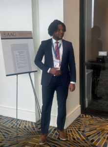
The author presenting at the AAG symposium he also chaired. Credit: Daniel Kissi-Somuah
The first session focused on urban mobility and exposure disparities, setting a strong foundation for critical thinking and reflection on spatial inequities. Papers examined e-scooter adoption in Charlotte, flow detection techniques for board-scale mobility data, and state policy implications for climate and worker health in Canada. Particularly notable was a paper proposing the use of Points of Interest (POIs) as sentinel nodes for infectious disease surveillance, offering a compelling intersection of geospatial methods and public health. All presenters made important submissions that sparked deep philosophical thoughts in geography.
The second session featured methodological innovations among geographically diverse studies, such as shared-bike mobility dynamics in Seoul, modeled carbon efficiency using urban scaling laws, and the linkages of urban sprawl with subjective well-being in the U.S. One presentation stood out for its novel use of geolocation data to examine tobacco exposure risks using a neuroscience framework. Another presented COVID-19 risk mapping in Kwara State, Nigeria, broadening the discussion to global health geographies and data-sparse regions. This session embodied the kind of interdisciplinary and cross-regional inquiry that the symposium aims to foster.
The final session turned attention to post-pandemic urban restructuring and digital-physical convergence. Presenters addressed the “donut effect” in U.S. cities due to remote work, correction methods for pedestrian mobility biases in Strava data, and the use of graph neural networks to estimate population flows from multimodal transport data. Two of the last presentations caught my attention: an analysis of mobility equity in four Atlanta neighborhoods in the context of the 15-minute city framework, and a forward-looking piece on GIS-based hybrid space-place approaches, emphasizing the need to rethink individual behavior across physical-virtual boundaries.
Throughout the day, the diversity of topics—ranging from graph theory and machine learning to behavioral geography and environmental justice—underscored the multidimensional nature of human dynamics research today. As an early-career geographer, I was honored to chair such a wide range of talks, with the opportunity not just to moderate, but to facilitate bridges between these ideas: connecting themes, fostering open discussion, and encouraging reflection on both technological promise and ethical responsibility.
AAG is not just a venue for presenting research, it is a dynamic community of thinkers, mentors, and co-creators of knowledge.
Presentation Insights: Sharing My Research
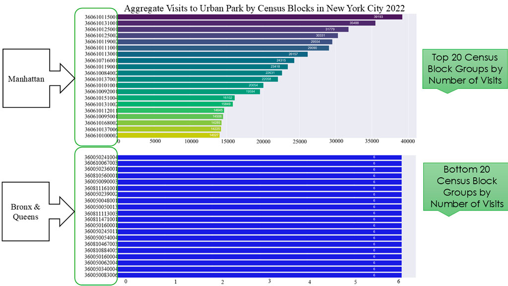
Among the highlights of the symposium was the opportunity to present my own research. I presented my study of how park visitation behavior varies across space, creating patterns that uncover inequities rooted in race, income, and location geography. Making use of longitudinal human mobility data from SafeGraph, the research revealed widening disparities in both access and usage of urban parks. More specifically, we showed that the borough of Manhattan enjoyed more access and use of parks—a predominately white area, compared with The Bronx, Queens, and Brooklyn, which are predominantly areas with people of color.
The author found that Manhattan enjoys far more access and use of its parks than other boroughs. Credit: Michaelmary Chukwu
My presentation illustrated persistent gaps in visitation trends, spatially and statistically, at the census block group level. Low-income and racially marginalized neighborhoods in New York City consistently lagged in park usage, despite proximity. Some parks in those block groups were not well-maintained and lacked or had uneven distribution of park amenities. This points to a deeper narrative: access is not solely about distance but shaped by systemic barriers—ranging from safety concerns to cultural disconnection.
As a first-time participant at the AAG Annual Meeting—and at the time, a master’s student at the University of Arkansas—chairing not one, but three sessions within the Human Dynamics Symposium was an experience that exceeded my every expectation. Entering such an intellectually charged and collaborative space, I initially wondered how I would measure up. But from the very first session, it became clear that AAG is not just a venue for presenting research, it is a dynamic community of thinkers, mentors, and co-creators of knowledge.
The privilege to engage with and learn directly from leading scholars in the field of human dynamics profoundly shaped my understanding of the many aspects of geographical thoughts and the future. I paid close attention to how leading researchers grounded their advanced methodologies in real-world challenges such as health disparities, urban inequity, and the need for technological foresight. I appreciated how questions were asked not simply to critique, but to expand, refine, and deepen shared understanding of science of geography. This experience will remain a defining moment in my academic journey, affirming that even as an emerging scholar, there is space to lead, learn, and belong in the evolving story of human dynamics.
Michaelmary Chukwu is a Ph.D. student in Geographical Sciences and Cartography at the University of Maryland. He completed a master’s degree in Geography from the University of Arkansas in 2025 and a bachelor’s degree in Urban and Regional Planning from the University of Ilorin, Nigeria in 2021. He is a student member of the American Association of Geographers (AAG), American Planning Association (APA), and Cartography and Geographic Information Society (CaGIS) while also being a distinguished full member of Sigma Xi and Phi Kappa Phi Honor Societies. Michaelmary’s research interests are in GIScience, urban mobility, spatial statistics, GeoAI, computational social science, urban studies, active transportation, and remote sensing. He has received recognition for his outstanding works including a national scholar award from the University of Arkansas and Third Place student poster at the Southwest Regional Division of AAG.
Perspectives is a column intended to give AAG members an opportunity to share ideas relevant to the practice of geography. If you have an idea for a Perspective, see our guidelines for more information.
Share
On the Map
The Hills of San Francisco
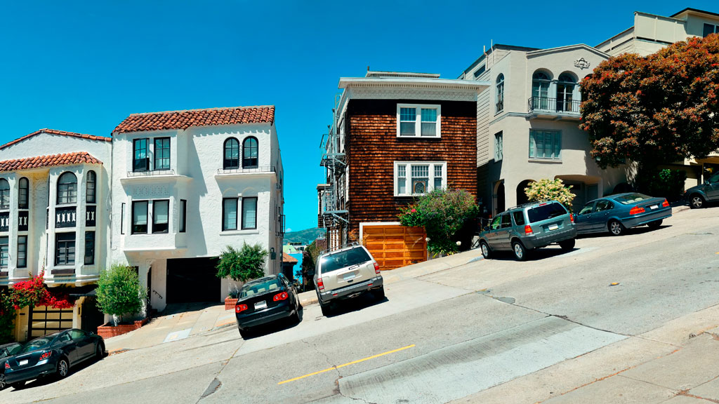
Street hill gradient in San Francisco
Unlike the rest of California, San Francisco has a unique geography that shapes its weather and settlement patterns. The city is set on the tip of a peninsula halfway up the coast of northern California, surrounded by bodies of water on three of its sides: the Pacific Ocean, the Golden Gate strait, and the San Francisco Bay. The city is laid out over hills that stretch from coast to coast, reaching heights of nearly 1,000 feet, making the climate similar to coastal areas on the Mediterranean.
The hills of San Francisco define its topography and culture. It’s hard to pinpoint the exact number in the city, but many sources consider there to be more than 50 named hills. As Pulitzer Prize-winning San Francisco Chronicle columnist Herb Caen notes in his introduction to the Hills of San Francisco, no one can quite agree on which [hills]. Although it’s debated among locals, there are seven hills that are iconic to the city: Russian Hill, Nob Hill, Telegraph Hill, Twin Peaks, Mount Davidson, Mount Sutro, and Rincon Hill.
So, when is a hill a hill? Self-proclaimed San Francisco explorer Dave Schweisguth claims, “When it’s a lone mountain. That is, if you can walk all the way around it, always looking up to its summit. It’s not so clear cut when hills run together into a ridge, which most of San Francisco’s do. Height alone is not so important: a very small hill may be perfectly obvious, while a string of higher summits may be hard to tell one from the next. It’s easier to call a hill a hill if it’s separated from its neighbors — if, on a topographic map, a contour line or two traces all the way around its summit.”
The Range of Iconography
Originally named Blue Mountain for the wildflowers that cover the hillside, the city’s tallest hill was renamed Mt. Davidson at the urging of the Sierra Club in 1911, after George Davidson, the geographer who surveyed it. It is the focal point of San Francisco’s Mt. Davidson Park, with a forest that accounts for more than 30 of the park’s acres, quietly remaining an oasis in the most densely settled city in California. Defined by a 100-foot cross at its peak, Mount Davidson stands at an elevation of 928 feet. Urban hikers share that despite how small the overall area is, the trails aren’t consistently marked, which causes explorers to get lost in the woods.
Hikers also recommend Mount Sutro, located in central San Francisco, for its role in the city’s cultural and natural history. Its century-old trails are now preserved by the University of California, San Francisco, which guides the long-term restoration of the 61 acres and protects the ecological oasis in the heart of the urban environment, along with the citizen group Sutro Stewards. The city’s elevation and abundant summer fog contribute to the mountain’s microclimates and its plant and wildlife communities.
Twin Peaks view in San Francisco. Credit: optionm, Getty Images
Originally called “Los Pechos de la Choca” (Breasts of the Maiden) by early Spanish settlers, Twin Peaks is a main landmark of San Francisco’s skyline, reaching elevations of 910 and 922 feet. Similar to Mt. Davidson and Mt. Sutro, Twin Peaks hosts a 64-acre park of coastal scrub and grassland communities that offer an idea of how San Francisco’s hills and peaks looked before development changed them forever.
Early in defining San Francisco’s history, Nob Hill, Russian Hill and Telegraph Hill continue to remain among the most popular neighborhoods to visit.
Lombard street in San Francisco Lockdown. Credit: Tiago Ignowski, Getty Images
Russian Hill’s name dates to 1847 when Russian sailors were buried on the hill during the gold rush in the 1800s. The burial sites are long since deeply covered, and it’s now only possible to admire a plaque at the site where the cemetery once stood. This is the same neighborhood home to the famous Lombard Street, that draws tourists from around the world due to its scenic switchbacks and postcard views. Because the slope in this area reaches 27° (51%), 8 hairpin bends were put in the 1300 feet between Hyde Street and Leavenworth Street to allow cars to drive down the street, ultimately creating one of the most winding streets in the world.
Russian Hill borders Nob Hill to the south, one of the city’s most upscale neighborhoods. Originally called California Hill (after California Avenue, which runs right over it), Nob Hill got its name from the word “nabob” that originated from the Hindu word meaning a wealthy or powerful person. This affluent neighborhood was home to the Central Pacific Railroad tycoons known as the “Big Four,” who were among the first to build their mansions here.
View up to Telegraph Hill’s Coit Tower. Credit: slobo, Getty Images Signature
Telegraph Hill hosts Coit Tower, an iconic piece of architecture that resembles a fire hose and affords incredible views of the city; its walls are also home to historic artwork. Originally, the Tower was a windmill-like structure created in 1849 to signal ships entering the Golden Gate. Once the trek is completed, the summit provides a breathtaking panoramic view of the city with landmarks like the Golden Gate Bridge, Alcatraz, and the Transamerica Pyramid.
Whether you’re taking a leisurely stroll or hiking the steepest routes, you can recall the words of the iconic San Francisco journalist Herb Caen, who once said, “Take anything from us — our cable cars, our bridges, even our Bay — but leave us our hills.”
You can hit the trails with a guided tour or explore the city on your own. The SF Gatecompiled a list of 11 hikes within the city limits that allow visitors and residents to get to know the landscape. An interactive map created by a UC Berkeley graduate student studying urban planning maps SF’s slopes and uses simple color coding to show where the flattest pockets of land are. If you’ll be attending AAG’s 2026 Annual Meeting in San Francisco, you’ll want to bring your walking shoes!
Share
President's Column
A Matter of Survival: Building Better Connections Between High School and College Geography
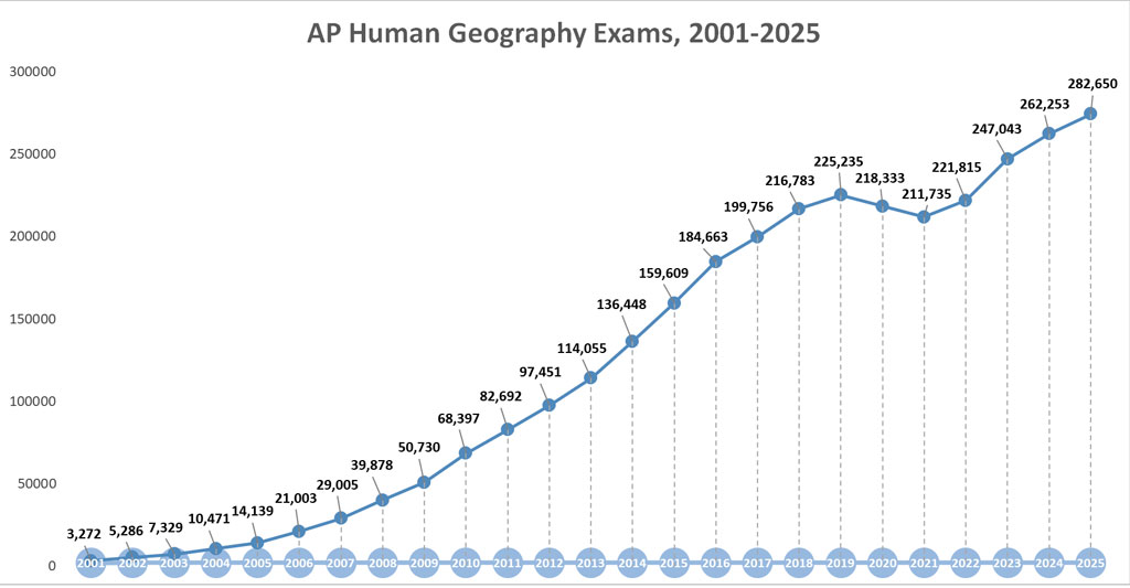
Some 283,000 students took the Advanced Placement Human Geography (APHG) exam this year, according to the College Board. Imagine if we could persuade even five percent of those students to major in geography at the college level. That would be 14,500 students a year, a number that is over 3.5 times the current number of students who graduate with a major in geography each year in the United States. This is untapped potential waiting to be leveraged at a time when many geography departments in the US are facing serious, if not existential, threats. We can and must do more to build better connections between high school and college geography.
In order to survive and thrive, any discipline needs at least two ingredients. The first is dynamic and cutting-edge research. A discipline makes a mark in the intellectual marketplace if it contributes to a better understanding of the world. Geography has arguably done well in this regard, and the AAG supports the scientific enterprise via its annual and regional meetings as well as its journals.
A discipline makes a mark in the intellectual marketplace if it contributes to a better understanding of the world.
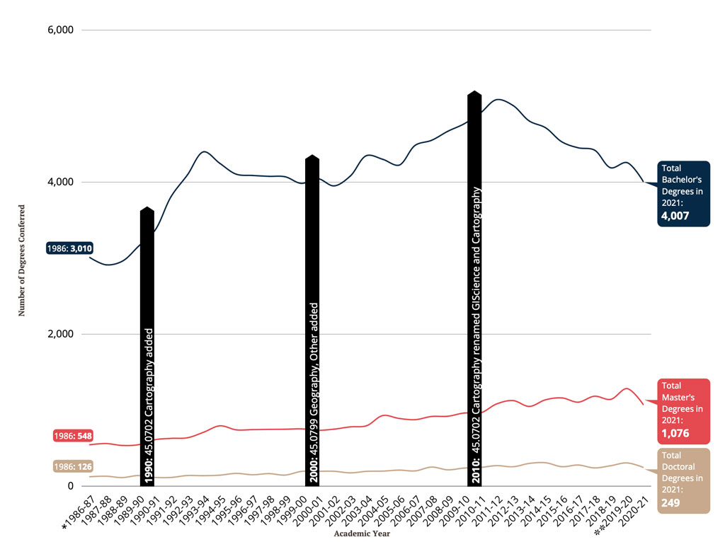
The second ingredient is a robust student body, both at the undergraduate and graduate levels. While US graduate programs in geography attract students from around the world, our undergraduate programs are relatively small and increasingly under threat. This is a problem at both a practical and philosophical level. At a practical level, undergraduate numbers are increasingly seen by administrators as a key indicator of long-term viability, and it is this pool of students that feeds, at least in part, graduate programs and the ranks of professional geographers. At a more philosophical level, many would argue that our population is better equipped to navigate the world and be responsible citizens when they have geographical training. The problem is that the number of undergraduate geography majors has fallen in the US by some 20% since 2011 (see Figure 1). How do we reverse this trend and rebuild and expand the undergraduate geography population in the US? The AAG is exploring this challenge very seriously and I am pleased to be part of an AAG taskforce on geography undergraduate education.
Figure 1: Geography Degrees Conferred in the USA, 1986-2021. Note: The * and ** refer to geography-related Classification of Instruction (CIP) codes created in 1980 and 2020, respectively. Source: AAG, 2022.
.
This past June I spent two weeks in Cleveland, Ohio preparing for and then grading AP Human Geography (APHG) exams (along with hundreds of other college and high school geographers). The irony is that I don’t like grading, but this is not why I have attended these events for over ten years. I go for the community, the opportunity to connect with high school and college geographers who teach the courses that introduce students to our discipline. These teachers are the foot soldiers of geography and it is their work that powers the long-term viability of our discipline as a field of study. I wish more university geographers and graduate students would participate in this event and, if you have not already done so, I would encourage you to consider attending in-person in the future.
The APHG story is a remarkable one. Starting with the first exam in 2001, at the behest of a small group of dedicated high school and college geography teachers, and supported by the AAG, the number of APHG exam takers has grown by leaps and bounds over the past 25 years (see Figure 2). The program is not perfect. For example, some 70 percent of high school students take the exam when they are freshmen, a stage when many believe young people are not ready for college level material. But the year-long course is comprehensive and rigorous, often representing the only exposure an American student will have to geography during their high school career.
Figure 2: AP Human Geography Exams, 2001-2025. Source: College Board. Source: Lisa Benton-Short and Dan Snyder, using data from Educational Testing Services, 2025
In my informal conversations with many APHG teachers, I have learned that there are a number of things we could do to better capitalize on the increasingly large number of students who take the APHG exam each year. Here are some preliminary suggestions for consideration.
First, even if they deeply enjoy geography as a subject, many high school students and their parents simply don’t know what one might do with a geography degree in terms of a potential career. This is a significant roadblock because it prevents students (and their parents) from seriously considering geography when they apply to college. While the AAG provides information on geography-related careers, we could do more to offer information that is accessible and tailored to high schoolers.
Second, many high school social studies teachers have limited university training in geography. As such, one of the key ways they learn how to teach the APHG curriculum is via AP summer institutes (AP sponsored summer training courses offered by certified, veteran high school instructors and college faculty). These courses could also provide teachers with more geography career-related information and tips on how to integrate it into their courses. For example, what types of professions are available to those who specialize in urban geography, GIS and cartography, or environmental geography? I would encourage APSI instructors to start doing more of this on their own accord, but they could also use more support from the College Board and the AAG.
Third, I believe that college geography departments and individual geographers have a responsibility to make connections with high school geography teachers near and far as a critical form of service to the discipline. As discussed previously, the way I have done this is through my engagement with the annual reading (or scoring) of the APHG exam, but others do this by becoming involved with their state level geography alliances (where they exist) or by reaching out to local high schools. In my case, these connections have led to guest lectures in high school classrooms, the co-authoring of articles with high school teachers and countless informal discussions about geography material. College geography students, perhaps coordinated and facilitated by local chapters of Gamma Theta Upsilon (GTU), the geography honor society, could also connect with local high school geography teachers to speak in their classrooms and share their experiences as geography majors. Let’s be honest, for an audience of high schoolers, college students are likely to be far more persuasive in terms of marketing our discipline.
If we are to survive and thrive as a discipline, geography needs to grow its base of undergraduate geography majors. We would be foolish to not build stronger connections with a rapidly expanding APHG program that represents an enormous pool of potential future students. A strong house needs a solid foundation. Please join me in helping to strengthen ours.
Please note: The ideas expressed in the AAG President’s column are not necessarily the views of the AAG as a whole. This column is traditionally a space in which the president may talk about their views or focus during their tenure as president of AAG, or spotlight their areas of professional work. Please feel free to email the president directly at moseley@macalester.edu to enable a constructive discussion.
Share
Register for Free
Create an account to get free access to exclusive AAG content.
AAG Members get exclusive access to publications, prominent journals, unique advocacy, grant, scholarship and professional opportunities with access to industry focus communities, and event discounts, including our annual meeting.
Some content may only be accessible if you belong to specific Specialty or Affinity Groups. You can still update your membership below. You will need to go through the Join flow, but you do not need to repurchase your membership unless it is expired or about to expire.
To provide the best experiences, we use technologies like cookies to store and/or access device information. Consenting to these technologies will allow us to process data such as browsing behavior or unique IDs on this site. Not consenting or withdrawing consent, may adversely affect certain features and functions.
Functional
Always active
The technical storage or access is strictly necessary for the legitimate purpose of enabling the use of a specific service explicitly requested by the subscriber or user, or for the sole purpose of carrying out the transmission of a communication over an electronic communications network.
Preferences
The technical storage or access is necessary for the legitimate purpose of storing preferences that are not requested by the subscriber or user.
Statistics
The technical storage or access that is used exclusively for statistical purposes.The technical storage or access that is used exclusively for anonymous statistical purposes. Without a subpoena, voluntary compliance on the part of your Internet Service Provider, or additional records from a third party, information stored or retrieved for this purpose alone cannot usually be used to identify you.
Marketing
The technical storage or access is required to create user profiles to send advertising, or to track the user on a website or across several websites for similar marketing purposes.
To provide the best experiences, we use technologies like cookies to store and/or access device information. Consenting to these technologies will allow us to process data such as browsing behavior or unique IDs on this site. Not consenting or withdrawing consent, may adversely affect certain features and functions.
Functional
Always active
The technical storage or access is strictly necessary for the legitimate purpose of enabling the use of a specific service explicitly requested by the subscriber or user, or for the sole purpose of carrying out the transmission of a communication over an electronic communications network.
Preferences
The technical storage or access is necessary for the legitimate purpose of storing preferences that are not requested by the subscriber or user.
Statistics
The technical storage or access that is used exclusively for statistical purposes.The technical storage or access that is used exclusively for anonymous statistical purposes. Without a subpoena, voluntary compliance on the part of your Internet Service Provider, or additional records from a third party, information stored or retrieved for this purpose alone cannot usually be used to identify you.
Marketing
The technical storage or access is required to create user profiles to send advertising, or to track the user on a website or across several websites for similar marketing purposes.


 Mirembe Ddumba is a junior studying Economics at Penn State University. She first became interested in geography during a Spring 2025 economic geography course, where she saw how maps and data could explain not just where things happen, but why communities grow and change the way they do. Using ArcGIS, she looked at how AI and shifts in different industries affect where people live and work, and realized that a map can sometimes tell a story better than pages of numbers. That interest led her to a Paragon Policy Fellowship, where she co-authored Charleston’s 2025–2027 flood-resilience plan and presented ideas to city leaders. She also co-created EcoGrow, a solar-powered smart farm with AI forecasting that won first place in a campus innovation challenge.
 Samra McCullin is a fourth-year student at George Mason University majoring in Geography with a minor in GIS. Samra’s first introduction to the discipline was a human geography class that she took in high school, where she found passion in the intersection of social, environmental, and physical sciences. In her undergraduate coursework she is constantly surprised at how she is able to exercise both her creative and analytical strengths. The freedom of a multidisciplinary major has allowed her to explore many subgenres within geography, her favorites being tourism, transportation, and sustainable development. Following graduation in the spring, Samra intends to pursue her masters in Geographic and Cartographic Sciences, working towards a professional career in digital cartography. Samra feels lucky to have found geography as a career path so early into her academic journey and hopes that through her work as a Communities Support Intern for the AAG, she can help more people find purpose and belonging within the discipline.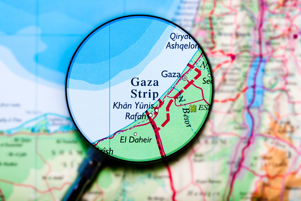

 This is the fourth of a short series of perspectives by 2024-2026 Council Treasurer Antoinette WinklerPrins–a series designed to help illuminate some of the financial challenges a professional organization such as the AAG faces. In this column, she offers perspectives on the financial aspects of running the AAG Annual Meeting.
  At the 2025 AAG Annual Meeting in Detroit, I had the incredible opportunity of serving as both a session chair and presenter for the 11th Symposium on Human Dynamics Research. This year’s symposium, themed “Human Dynamics and GeoAI,” marked a major evolution of geographic thought—building on a decade of intellectual contributions that have redefined how we understand human-environment interactions in increasingly multifaceted physical and virtual worlds. Thanks to Dr Xinyue Ye, Department of Landscape Architecture and Urban Planning, Texas A&M University and Dr Xiao Huang, Department of Environmental Sciences, Emory University, for allowing me to take up such a monumental adventure—one that has shaped my experience of AAG for the better.