Recognizing the Work of Graduate Students
    Share

David Huff

David Huff, Professor Emeritus of Marketing and Geography at the University of Texas at Austin, and giant in the field of applied geography, passed away on August 15, 2014, aged 83.

David L. Huff was born in 1931 in McMinnville, TN, then spent an idyllic boyhood on Lake Oswego, OR. At first he struggled to find a college or career that held his interest, trying many jobs and five undergraduate universities, plus a stint in the Army.

His academic motivation and interest was finally sparked at the University of Washington in Seattle, WA, at a time when quantitative geography was just emerging. Throughout the time of his MBA and PhD, he was strongly influenced by early analytical economic geographers and early quantitative sociologists, game theorists and rational choice theorists. He emerged from this exciting time in graduate school as a holistic quantitative social scientist. His doctoral thesis work from 1959 to 1962 in modeling trips to shopping centers and stores was published in 1963.

Huff’s first teaching position was at UCLA where he was very quickly promoted to tenure as a business and marketing professor because of his early accomplishments. It was here in 1964 that he developed the Huff Model to forecast market share and retail attractiveness. It is based on the premise that when a person is confronted with a set of alternatives, the probability that any particular item will be selected is directly proportional to the perceived utility of each alternative.

The model is an excellent example of a bridge between geography and business. It soon entered the textbooks and was used by academicians and practitioners throughout the world. Its popularity and longevity can be attributed to its conceptual appeal, relative ease of use, and applicability to a wide range of problems, of which predicting consumer spatial behavior is the most commonly known.

For the last 50 years the Huff Model has been taught in courses across marketing, economic geography, economics, retail research, urban planning and decision theory. It has been widely used by market analysts and planners to locate convenience stores, shopping malls, and other types retail establishments. It continues to be the standard model for the industry and is now incorporated into GIS systems.

Among Huff’s other academic contributions were the application of multivariate graphic displays to market analysis, the formulation of objective measures for delineating market areas, the development of computerized systems to monitor economic activities geographically, and the derivation of planning regions for the geographic delivery of health care and economic services.

After UCLA Huff took a Fulbright Lectureship at the Université d’Aix-Marseille in France which started a life-long love of French culture. He then moved to the University of Kansas as Director of the Center for Regional Studies but this position did not allow him the time he needed to do basic research so he readily accepted an offer from the University of Texas to become Century Club Centennial Professor of Business Administration where he remained until retirement.

In addition to his work in academia, Huff consulted for dozens of agencies including the U.S. Department of Transportation, Resources for the Future, National Institutes of Health, U.S. Bureau of the Census, and National Endowment for the Arts, as well as for numerous state and regional offices. He has advised hundreds of business firms on various aspects of market area analysis. In 2003 he was invited by Esri to become a technical advisor, using his expertise to develop advanced predictive models and review existing analysis capability in Esri’s business analysis products and services.

During his academic career, Huff received numerous teaching awards and much prestigious professional recognition. For example, the AAG awarded him the James R. Anderson Medal in Applied Geography in 1988, and he was the recipient of the Distinguished Mentor Award from the National Council for Geographic Education in 1998 in recognition of his long history of successful mentoring of master’s and doctoral students.

David had remarkable standing in the profession. He was a man who loved his work, was always full of enthusiasm, and generous with his time and talent. He will be missed by many, not only colleagues and friends, but also business professionals and the whole applied geography industry.

He leaves behind his wife of 61 years, Suzanne, his children Nancy, Karen and David, as well as 10 grandchildren and a growing brood of great-grandchildren.

    Share

The More-Than-Conference Conference

Mona Domosh

Courtesy of the Great Lakes Feminist Collective.
Front and back of the postcards distributed by the Great Lakes Feminist Collective at the 2014 AAG conference in Tampa, FL. Courtesy of the Great Lakes Feminist Collective.

I was surprised to see the line snaking around the entrance to the Past President’s Plenary at this year’s AAG conference in Tampa. Of course folks wanted to hear Eric Sheppard’s address, I thought, but honestly the only lines I had seen at the conference ended at a ‘free drinks’ bar. Things became clearer as I approached: there were people standing at the entrance to the room handing out postcards, and so fellow geographers were lining up to get one; not wanting to miss anything I took all three. As it turned out, they made excellent reading material (see figs. 1-6). Each card provided verbal and visual information about aspects of the discipline and the academy in general that the Great Lakes Feminist Geography Collective found wanting. Just the day before I had attended a session of what is called the subconference where we had talked through related issues facing junior scholars working in the academy: lack of support for social reproduction, increasing use of contingent faculty, the enduring impacts of the great recession, and so on. There were I realized many different confer-ings going on at the conference, all in some way related to it but differing in type and scope.

Almost all conferences exceed what is listed on the program; social interactions among groups of people are never fully scripted. And what is commonly referred to as “the AAG” — a deceptively short and unassuming name for what often exceeds definition — is certainly no exception. Even the full title — the Annual Conference of the Association of American Geographers — just doesn’t seem adequate to describe the excitingly and dauntingly large, diverse, social, performative, professional and personal gathering that happens once a year in a large American city. Those of us who have attended “the AAG” know that it is much more than the 5,000 or so papers, posters and plenaries that are presented. There are workshops, field trips, receptions, preconferences, parties, meetings, in-the-hallway-chats, dinners, and drinks that merge our professional and personal lives. And there are “other” events too, those meant to provoke, protest, initiate, and investigate. Given that these activities often take place in the interstitial spaces of the conference and are not visible to everyone, I highlight them here because I believe they are important signs of the liveliness and dynamism of our discipline.

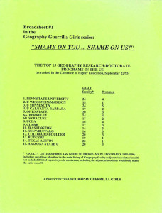
Figure 7. Broadsheets distributed by the Geography Guerilla Girls at the 1996 AAG conference in Charlotte, NC. Courtesy of the Geography Guerilla Girls.
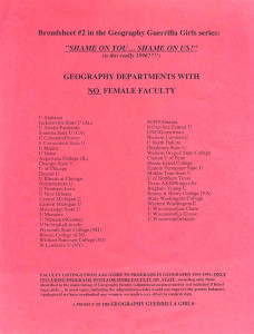
Figure 8. Broadsheets distributed by the Geography Guerilla Girls at the 1996 AAG conference in Charlotte, NC. Courtesy of the Geography Guerilla Girls.

Like most political interventions, the idea of the postcard “drop” (as the Collective calls it) wasn’t born anew. From what I’ve gathered from my own memory and that of fellow geographers (I sent out a message on several listservs that reached about 4,000 geographers, asking for information about “other” activities that have occurred at our conferences; thanks to all of those who responded) there have been several instances in the past when individuals and groups have distributed protest literature. One geographer remembered Bill Bunge handing out anti-nuclear flyers at the door of a plenary session at the Detroit conference in 1985, and no doubt there have been similar interventions since then. The Collective’s website traces the “drop” to the action taken by a group of Canadian feminist geographers at the 2002 AAG conference. The group compiled statistics about the number of women in geography, printed the information on pink sheets, and distributed them throughout the conference, keeping the authorship anonymous. Reactions were mixed, they write, but the act of compiling information that vividly depicts inequities and distributing it widely had multiple effects. Six years before that, a similar intervention occurred at the Charlotte AAG conference, when an anonymous group called the Geography Guerrilla Girls distributed two broadsheets that documented the paltry number of women faculty in geography departments in the United States (see figs. 7, 8). So the Collective’s postcards drew on and were contributing to an interesting historical geography of the politics of Geography. At the same time, another contribution to that historical geography was being enacted in Tampa. Graduate students from the University of North Carolina — inspired they say partly by Antipode and the critical geographic inquiry it represents — had put together a zine on Black Geographies called The Whirlwind that they handed out to geographers attending related sessions on geography and race/racism, an important and lively addition to the discipline’s history of protest literature.

The subconference too draws on an historical geography of the politics of the discipline as geographers have sought alternative ways to gather and discuss issues not usually encountered in the official hallways and meeting rooms. For example, GPOW (Geographic Perspectives on Women specialty group) has organized a reception coincident with the AAG celebrating recently published feminist geography books at a local bookstore each year since 2005, creating alternative spaces for networking and collaboration close to the conference site but not in it. The idea of the subconference has its roots in several sets of discussions held at various venues, and took form for the first time in 2010 at the D.C. conference. Since then it has evolved into a series of sessions listed on the program but organized specifically not to follow the template of ‘regular’ sessions; instead, facilitators lead discussions geared to issues not often addressed (though certainly talked about) formally at conferences: work-life balance, child care, mental health, disabilities, contingent faculty, impacts of the recession, the neoliberalization of the academy. And word is out that about the need for this type of intervention: a group of MLA (Modern Language Association) members organized a subconference at their last meeting (make sure to read down the page to see the nice shout out to the subconference of the AAG!). A similar attempt to open alternative spaces for new types of conversations within the discipline was apparent in a set of sessions geared toward mental health issues, and in past years, a set of sessions on “deaf geographies.”

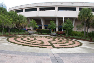
Figure 9. Photograph of an on-site maze constructed at the AAG conference in Tampa Fl. Courtesy of Lance Howard.

Other complementary sites that revolve around “the AAG” are geared toward opening the conference to different forms of expression. I have memories of past AAG hallways lined with carefully curated photographs, but I can’t seem to find information about who or what organized these exhibitions. In Los Angeles a group of geographers organized an art exhibition called “Curating the Cosmos” that accompanied a series of sessions with the same title, making important interventions into understanding what the geohumanities might look like, while another geographer created an on-site maze as a form of impromptu landscape art (see fig. 9). And for the past three years a group of geographers have coordinated a four-hour map-a-thon mash-up that is held in conjunction with the AAG but at a different site, thus encouraging creative digital cartographic expression and inventing new arenas for networking and community building.

No doubt this is a partial and selective accounting of the many “other” activities that coincide with our annual conference (and I would love to hear about more). I hope that highlighting these few interventions suggests the importance of the more-than-conference aspect of our conference, of the ways that “the AAG” provides a platform for self-critique and creative intervention, and of how these provocations and investigations keep the discipline dynamic and create space for changing its contours. These are signs of the liveliness of our discipline, of people and communities who care enough to prod and poke us. I look forward to hearing about other interventions and experiencing them in Chicago and beyond.

— Mona Domosh

DOI: 10.14433/2014.0014

    Share

Strategic Essentialism and Radical Intra-Disciplinarity

    Share

The Future of Physical Geography

    Share

MyCOE / SERVIR Capstone Fellows Describe Their Experiences

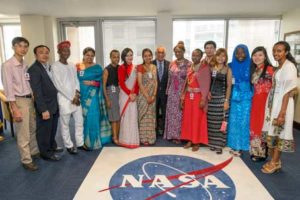
[/media-credit] Joel Kowsky, NASA
In the spring, 14 students traveled from all over the world to Washington, D.C., to discuss their efforts using satellite data and mapping technologies to address climate change issues in their regions. The efforts are part of the My Community, Our Earth (MyCOE) / SERVIR Fellowship Program. The student-led projects address a range of issues including agricultural productivity, water resources, sea level change, food safety, forest conservation, and natural disaster planning.

The event was a culmination of a global program carried out over the past two years, with representative student-led projects highlighting how youth around the world are using remote sensing, GIS, GPS, and geospatial data to address climate change issues in their regions. The 14 students were selected from the 120 participants who were nominated by instructors and staff of the MyCOE Program and SERVIR hubs and chosen by U.S. Agency for International Development (USAID) and NASA.

View the inspiring testimonials from these fellows:

Khin Seint Seint AyeImpact of famous floating gardens on the environment and livelihoods of a unique Inle lake in Central Myanmar

Susan MalasoApplication of GIS and RS Techniques in Frost Risk Mapping for Mitigating Agricultural Losses in Kenya

LhakpaLinking Traditional Beliefs on Climate Change to Scientific Understanding: A Case Study in Eastern Bhutan

Tsedenya Abebe MengisteAssessment of Flood Frequency and Local Adaptation Practices in Dilu-Meda, Upper Awash, Ethiopia

Prasamsa ThapaSurface Area Variation and Climatology of Tsho Rolpa Glacial Lake using Remote Sensing and GIS, Dolakha District, Nepal

Jirawat PanpengVulnerability of Rural Coastal to Potential Sea Level Change: Case of Laemsing District, Chanthaburi Province, Thailand

Roseline Nijh Egra BatchaParticipatory Learning and Gender Partnerships in Climate Change and Food Security: Mfoundi-Yaounde Cameroon

Joyeeta PoddarAssessment of Glacier Health as a Response to Climate Change in Western Himalayas, India

Khoa NguyenChanges of paddy rice extent and its possible effect on the environment in Mekong Delta, Vietnam

Seble DejeneCarbon Stock Estimation in Wof-Washa Natural Forest: Carbon Finance Options & Climate Change Mitigation, Ethiopia

Pramila PaudyalClimate Change Vulnerability in Mountain Agriculture: A Case Study Of Susma Chhemawati VDC, Dolakha District, Nepal

Wasiu AlimiAssessment of the Climatic and Socio-Economic Impacts of Illegal Logging in a Rainforest: The Role of Women, Nigeria

Lateefah OyinlolaAssessment of vulnerabilities of fresh cut produce to climate change in South Western Nigeria

Tran Thi Mai AnhApplication of GIS and Remote Sensing in Administering Payment For Forest Environmental Services at Huong Son Hydroelectric Power Plant’s Watershed, Vietnam

The MyCOE / SERVIR program supports long-term training of young, emerging scholars in the use of Earth observations, geography, and geospatial technologies to address climate change issues in developing regions. The public-private partnered program provides the mentorship, networking, and professional development necessary to transform innovators into scholars, with the skills to connect their research results to the public and decision makers. It is sponsored by NASA, USAID, and AAG, with the AAG also administering the program. SERVIR, an acronym meaning “to serve” in Spanish, is a joint venture between NASA and USAID. SERVIR works in partnership with leading regional organizations around the globe to help developing countries use information provided by Earth-observing satellites and geospatial technologies to better manage climate risks and sustainability of natural resources.

To learn more about the full My Community, Our Earth / SERVIR program, contact Project Director Dr. Patricia Solís at psolis [at] aag [dot] org. Or, visit https://www.aag.org/mycoe.servir. Read more detailed information on the NASA event.

    Share

Two Geographers Awarded 2014 Guggenheim Fellowships

Anthony Bebbington, professor and director of Clark University’s Graduate School of Geography, and Diana Liverman, professor at the University of Arizona, were recently awarded a 2014 John Simon Guggenheim Memorial Foundation Fellowship. They were among the 178 scientists, artists and scholars from the almost 3,000 applicants from the United States and Canada to receive an award this year.

Bebbington’s award was in support of his forthcoming book, “Natural resource extraction in Latin America: transforming the human-environment, challenging social science.” His research addresses the political ecology of rural change, with a particular focus on extractive industries and socio-environmental conflicts, social movements, and indigenous organizations and livelihoods.

Starting in late summer, Liverman will use her one-year fellowship to write a book on poverty and climate change in the Americas. She plans to outline policies that work with communities to reduce climate risks through a variety of programs, such as small-scale irrigation and water conservation, shade, mobility and warning systems. Her goal is to identify solutions that eliminate poverty, reduce emissions and help people adapt to climate change.

Established in 1925 by former U.S. Senator and Mrs. Simon Guggenheim, the foundation has sought from its inception to “add to the educational, literary, artistic, and scientific power of this country, and also to provide for the cause of better international understanding. The foundation has granted more than $315 million in Fellowships to almost 17,700 individuals, including scores of Nobel laureates and poets laureate, as well as winners of Pulitzer Prizes, Fields Medals, and other important, internationally recognized honors.

    Share

How to Succeed in Business with a Degree in Geography

There are many business opportunities for people with geography degrees. I have three degrees in geography and 33 years of working experience in the business world. I’d like to share my real-life experience and hope that it will offer insights and incentives to those who contemplate a career in business. Let me present my story in a question-and-answer format:

Did you plan to have a career in business? I never thought of having a career in business. After I got my doctoral degree, I taught world regional geography and urban geography at Boston University in 1977 and then in 1978 and 1979 at the State University of New York at Cortland. Both teaching positions were short-term and non-tenured. Tenure-track positions were hard to find. I needed to think of alternatives.

How did you select a career in business? In late 1979, China opened up to doing business with the West. Many American companies were very interested in entering the Chinese market but didn’t know how. Since my specialty was China, I thought I could help them open some doors in the new Chinese market.

How did you find your first job at a company? I sent more than 500 letters to companies across the United States, telling people I could help them develop the Chinese market. I got a dozen interviews, and I landed a job as the China Area Manager at Academic Press, Inc., a wholly-owned subsidiary of a Fortune 500 publishing company called Harcourt Brace Jovanovich (HBJ).

How much did the job pay compared to your previous academic positions? My business position paid me twice as much as my first full-time academic position. I also got to learn a business and how things work, including global expansion skills.

Why would a Fortune 500 firm hire you with no background or experience in business? The chairman of the company traveled to Beijing, China to drum up new business, but he had a hard time getting along with the Chinese and vice versa. One of the 500 letters that I had mailed out landed on his desk. He told the senior vice president to hire me. The company needed my geographic knowledge of China and my language skills to help them navigate that market.

What happened next? I succeeded in getting my first prepaid order for my company ($150,000 in 1982 – $330,000 in today’s value). Sales to Southeast Asia tripled. Two years into my job, the company wanted to relocate from New York City to Orlando, Florida. I didn’t want to go to Florida. I quit my job and started my independent consultancy in May of 1983.

Why did you start a consultancy? Since I had succeeded in opening the Chinese market for Academic Press, I sent 300 letters to publishers across the country. Within 3 months, I had 3 paying clients, including Rand McNally & Co., the map-making publisher who wanted me to sell maps and globes to China.

How much is your success in consulting related to your degrees in geography? I apply what I know about Chinese geography and cultural geography to day-to-day problems in business. I’ve worked with more than 100 U.S. manufacturers, trade associations, and service organizations. Businesses need people with geographical and cross-cultural knowledge.

Could you give an example of how you applied geography to a business problem? A company spent $1,000,000 on postage each year to mail catalogs worldwide. I looked at its bloated mailing list and found that there were many duplicate records. This means that quite a number of people received multiple copies of marketing materials. Many names on the list were misspelled and out-of-date. I surveyed our worldwide customer base and eliminated duplication and waste. Management was very happy because I reduced their costs.

Could you give another example of applying geography in business? As a cultural geographer of China, I know that there will be misunderstandings between American managers and their Asian counterparts. One time, K-Mart wanted our company to import 100,000 Santa Claus dolls. Our manager asked our Taiwan representative to send in a sample. I looked at the sample and found that the torso had a piece of wood inside. This was not good because if a doll body had a solid core, we had to pay $1 per doll in import duty. I sent the sample back to our office in Taiwan and asked them to replace the wood with fabric so that we could import the dolls duty free.

Do businesses really appreciate geography? They do. They need people with geographical knowledge and perspective to get things done. In 1996, the American Management Association (AMA) commissioned me to create and teach a three-day course titled “Business Skills for the China Market” to executives from Fortune 1000 companies who wanted a crash course on China. I became the first person in the United States after 1949 to do this. Recently, Lockheed Martin asked me to create and teach a one-day course on China. Such needs are there. Companies may not think of solutions for their needs coming from geography. It is up to people with geography degrees to create solutions and make them relevant and resonant.

What advice would you give to someone with a geography degree about succeeding in business? Start at an entry level and learn a business. Geography is not a trade. It is an academic discipline. Once you know enough of a business, you can apply your unique training as a geographer to look at things in a way that people trained in other disciplines may not come up with. This is how you differentiate yourself and become competitive. Few businesses pay us to teach them geography. They just want us to solve their problems and get things done. It’s up to us to invent ourselves.

Author’s note: I wrote this piece to commemorate my long-time friend and personal mentor, Forrest (“Woody”) R. Pitts, an accomplished geographer, who passed away on January 8th, 2014. When he was alive, Woody kept telling me that geography had benefited me professionally, even though I never conducted research as an academic. Woody was right. I was wrong. I am grateful to geography and the life journey which it inspired me to take.

Editor’s note: This article originally appeared in the UC Santa Barbara Department of Geography website. Reprinted with permission from the author. 

DOI: 10.14433/2014.0011

    Share

New Books: June 2014

Every month the AAG compiles a list of newly-published books in geography and related areas. Some are selected for review in the AAG Review of Books.

Publishers are welcome to send new volumes to the Editor-in-Chief (Kent Mathewson, Editor-in-Chief, AAG Review of BooksDepartment of Geography and Anthropology, Louisiana State University, Baton Rouge, LA 70803).

Anyone interested in reviewing these or other titles should also contact the Editor-in-Chief.

June, 2014

    Share

A Decade of Change: AAG Returns to Chicago

The AAG is pleased to be holding its next annual meeting April 21-25, 2015, in the world-class city of Chicago.  The AAG last met in Chicago in 2006, and in the newsletter issues leading up to the 2015 meeting, the Local Arrangements Committee (LAC — chaired by Professor Euan Hague, Chair of the Geography Department at DePaul University) will provide articles that highlight some of the more dramatic changes in Chicago since then. This first article provides an overview of some of the themes of change discussed by the LAC at its first Chicago meeting on May 24, 2015 — these themes will be presented in greater detail in coming issues.


The AAG 2015 conference hotel, Hyatt Regency, 151 East Wacker Drive, Chicago


Population Redistribution

The 2010 Census reported that the 16 county multi-state Chicago–Naperville–Michigan City, IL–IN–WI Combined Statistical Area (2004 definition) had a population of 9.68 million.  That means that the Chicago region grew by 4 percent between 2000 and 2010, which was considerably slower growth than the previous decade (1990 to 2000) when the same 16 county metropolitan area grew by 11.1 percent.  The population loss in Chicago proper (with the exception of its Downtown) and the inner suburbs was largely responsible for the growth slowdown, for instance between 2000 and 2010 Chicago lost over 200,000 residents.  Meanwhile, the outer suburbs helped offset these latter declines, for instance the 3 largest outer suburbs of Chicago (Aurora, Joliet, and Naperville) together added 109,616, a little over half the amount that the City of Chicago lost. This reflects a continued long term trend in the Chicago region of population decentralization from Chicago’s core to the edge, despite a slight pause in that trend in the 1990s when the City of Chicago actually gained population for the first time since the 1950 Census.  Meanwhile Downtown Chicago deserves special attention as its population saw a 114 percent increase from 1990 to 2010.  This population increase was paralleled by a residential housing boom that has included the conversion of former Downtown office spaces to residential units and new high-rise apartment buildings and condominiums have sprouted up in and around Downtown – a theme that was highlighted in a special map provided to AAG attendees at the 2006 AAG meeting.

The LAC is working on field trips that will showcase various aspects of Chicago’s recent population redistribution trends and an upcoming newsletter will go into greater detail on these population shifts.

A Greener Chicago

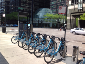
The 2006 AAG meeting publications highlighted Chicago’s efforts to expand upon its rich heritage of city parks and greenways and those efforts have continued.  The Openlands Project was founded in 1963 and since then it has helped secure, protect, and provide public access to more than 55,000 acres of land for parks, forest preserves, land and water greenway corridors, and urban gardens.  Participants of the AAG meeting will be able to link up with this vast network of greenways within walking distance of the conference hotel.  Just blocks away is Millennium Park which is currently celebrating its 10th anniversary and special events continuing into 2015 will celebrate this magnificent park space by showing off its world-class art, music, architecture, and landscape design.  Another “green” milestone reached by Chicago’s is its commitment to bicycling as it has built over 200 miles of on-street bike lanes including one that weaves 1.2 miles through downtown within a buffer that separates it from cars.  Chicago also has a Divvy (divvybikes.com) bike sharing program with the largest number of stations of any city in the United States.


Corner of Monroe and Canal Street, Chicago, by author 24 May 2015.


The LAC is already working on field trips that will visit components of the greenway system of Chicago and an upcoming newsletter will go into greater detail on many other aspects of the greening of Chicago.

Chicago’s Food Systems

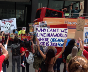
The Chicago region is the command and control center for U.S. industrial agriculture (center of the Corn Belt) yet it is also a leader in alternative agricultural systems including a very active local food movement that emphasizes organic and natural choices.  The Chicago food theme is one that the LAC is particularly interested in as several members are actively researching the issues, so upcoming newsletter stories will review the status of the region’s ties to traditional industrial agriculture as well as the growth in alternative systems.  As coincidence would have it when the LAC met on Memorial Day 2014 weekend a massive crowd of protestors assembled in the Loop to demonstrate against the use of genetically modified organisms (GMOs) and to promote a call for locally grown organic alternatives.


GMO protest at Federal Plaza on Jackson Blvd and Clark Street, Chicago, by author 24 May 2015.


The LAC is working on field trips that will visit parts of the corn-belt within range of Chicago and it will also show case locally grown components of the new Chicago food system including retail configurations that attempt to turn food deserts into food oases.

Lake Michigan and other Regional Water Resources

Chicago sits adjacent to Lake Michigan and the growth of the metropolitan region’s population and spatial extent have caused concern among regional planners over the potential for future water supply shortages.  The Metropolitan Planning Council (MPC) is promoting a regional approach to sustainable water supply planning and management.  Chicago and many of its inner suburbs are already withdrawing Lake Michigan water to meet their needs and as the outer suburbs speculate about their own future shortages from dwindling local ground water supplies they are being warned that Lake Michigan water may not be available.  All of this may seem odd given the vast size of Lake Michigan, but international laws with Canada limit withdrawals.

The LAC is working on the development of a field trip to showcase these and other regional examples of innovations in water resources management.  Views of the Chicago River and Lake Michigan are a close walking distance from the conference hotel and just a little further, just a mile, is Navy Pier which puts you slightly above and out onto the Lake.

Transportation 

Chicago is a large centralized gateway to international trade and traffic for the United States.  Chicago continues to grapple with the growth in freight flows that often test the capacity of the region’s transportation infrastructure.


Photo taken from a freight yard in Southwest Chicago on 28 May 2005.


As in 2006, almost all of the container freight on these railcars is transferred to and from trucks which take up twice the road space of cars on the region’s highways.

On top of the container-freight issue, the Chicago region is grappling with a host of other transportation issues including the goal of expanding public transportation services.  The edge cities toured during the last AAG meeting have matured and exhibit both traditional and reverse commuting patterns.  The Loop is still the dominant job center of the region and the peak commuting flows reflect this, however, there is a growing gentrifying population that works in the suburbs but lives and consumes in the city, which only adds more complexity to the pattern.  New retail configurations in the suburbs like Lifestyle Centers are adding to non-work related trips and suburban gridlock is common place on the weekends.  The Local Arrangements committee is working on field trips that will show-case some of the problems identified here as well as some of the existing plans that are in place to alleviate the problems.  The conference hotel is also directly accessible to public transportation, particularly the “L”, and extensive bicycle paths are within walking distance toward the Lake.

Race, Immigration, and Ethnicity

The LAC will write a newsletter piece prior to the meeting that articulates some of the changing dynamics and patterns of Chicago’s racial and ethnic diversity since the last meeting in 2006.  Topics to be covered will include the degree to which multiethnic neighborhoods have expanded or contracted or whether classic patterns of segregation have reemerged.  The piece will examine the tension that gentrification has posed to the stability of some of the city’s more stable ethnic enclaves.  The geographic dimensions of the growth in Chicago’s China Town will be described.

The Local Arrangements Committee already has plans to visit the Pilson neighborhood, a Latino neighborhood that has seen continued pressure from gentrification since the last meeting in 2006.

So as you plan your trip to Chicago, save time to explore these and many other aspects of change that Chicago has experienced since 2006.  Bring your walking shoes and depending on the weather you may even consider renting a bicycle to tour on the greenways of Chicago accessed in front of the conference hotel.  Venture into some of Chicago’s ethnic neighborhoods for unique dining experiences.  Or possibly even plan a journey from Downtown to the Edgeless exurbs of Chicago.

    Share