Member Profile: Kenneth Martis

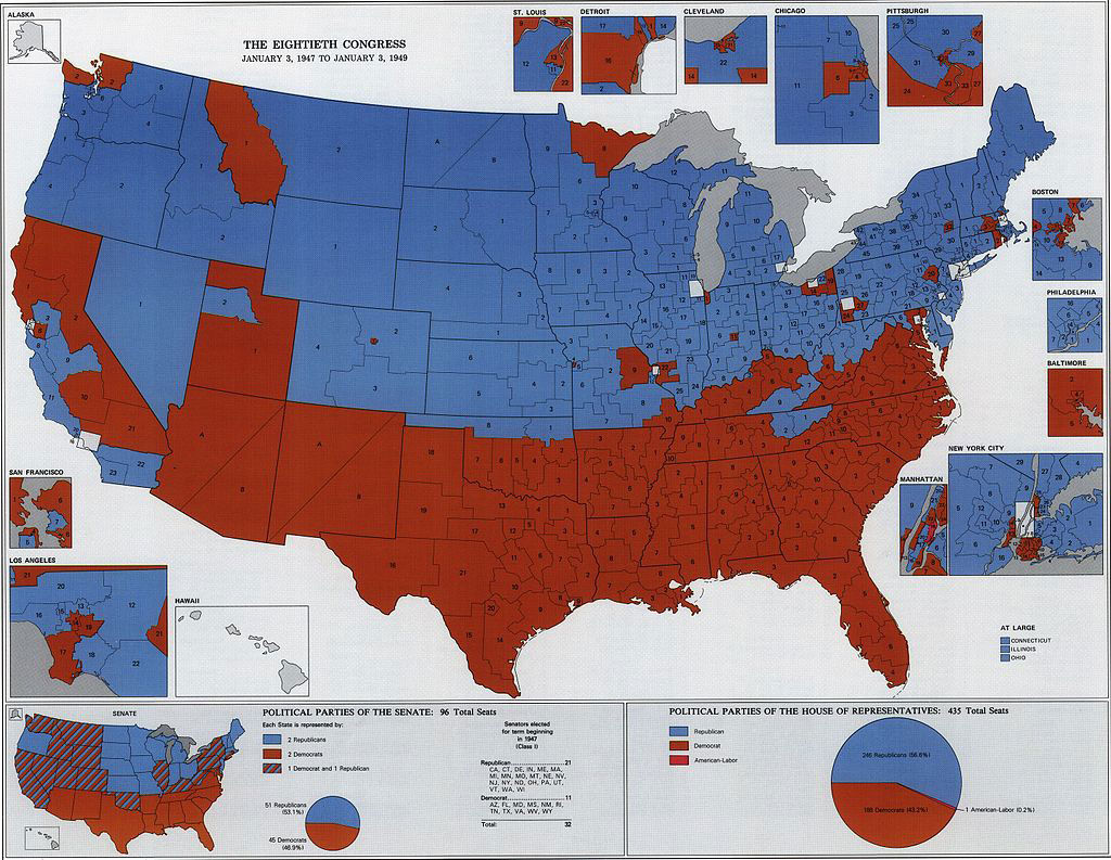
Ken Martis created the map to visualize the political party division of the 80th Congressional Congress.
Credit: Kenneth C. Martis, Ruth A. Rowles, cartographer, Gyula Pauer, production cartographer (full image shown below)

As a graduate student at the University of Michigan in 1972, Ken Martis stumbled on one of the greatest information vacuums in political geography — the lack of documentation for congressional districts since the founding of the United States. He decided then and there to fill the gap. His quest would result in groundbreaking research, nine books, and a lifelong calling.

“I had just chosen a dissertation topic,” Martis recalls, “which was mapping roll call votes in the United States Congress. I was focused on voting patterns on natural resources, conservation, and the environment through time, starting with the earliest congresses through the environmental issues of the 1960s.” To get started, Martis went to the university library — one of the biggest in the nation at the time — to find national-scale district maps for the last 170 years. The reference librarian took him through the card catalog. Then the Guide to Reference Books. They could find nothing. “She was as puzzled as me. She told me to give the staff a chance to look into it, and to return the next day. So I did. I was met by the librarian and the head of the reference department. They’d turned up nothing, not even for landmark eras like Abraham Lincoln’s time.”


“I realized I could be the first person in American history to map every congressional district from the First Congress forward,” he says. “It was humbling, and exciting.”

Martis is now Professor Emeritus in the Geology and Geography Department at West Virginia University. He is the author or co-author of award-winning books that have fundamentally shaped our awareness of political patterns in the United States. His first historical political atlas was The Historical Atlas of United States Congressional Districts: 1789-1983, with maps by cartographer Ruth A. Rowles. This book was the first to map every congressional district and analyze every apportionment change for every state for all of United States history. It won numerous honors, including the American Historical Association’s Waldo G. Leland Prize for the best reference book in all fields of history for the period 1981-1986. He went on to write eight additional volumes with partners, including a historical atlas of congressional political parties, a historical atlas of congressional apportionment, and the 2006 Historical Atlas of U.S. Presidential Elections 1788-2004. He has continued to document the American political landscape with co-edited works on the pivotal 2012, 2016, and 2020 elections.

Geography as Lifeline

Martis’s four grandparents and father were Slovakian immigrants from Austro-Hungary in the early 1900s. He was also the first in his family to finish high school, attend college, and attain advanced degrees. “My mother saved my grade school report cards,” he says. “They show I was a poor to average student, except in one area; geography! I loved it.”

His love of geography saved his academic career in college at the University of Toledo. After several semesters he describes as “disastrous” and himself as “barely surviving,” Martis took geography courses with engaging professors, and found his academic passion. One Toledo geography professor in particular, Dr. Donald Lewis, took Martis under his wing. “I have told him several times, he is my number one influence in becoming geographer.”

I realized I could be the first person in American history to map every congressional district from the First Congress forward.” 

The selection of geography courses and excellent professors were no accident. “The Department of Geography at the University of Toledo is a story unto itself,” says Martis. In 1958, the university appointed a new president, arctic geologist Dr. William S. Carlson. Carlson earned his B.A., M.S., and Ph.D. from the University of Michigan, where his graduate advisor was geologist William Herbert Hobbs, president of the Association of American Geographers in 1936. In 1963 President Carlson finalized the creation of a new stand-alone Department of Geography and hired full-time tenure-track faculty. Martis was among the first beneficiaries of this investment.

“Your journey in life is marked by the many choices or paths you select,” he says now. “Nevertheless, the mere existence of the path is predicated by hundreds of choices previously, mostly by people you will never know. What if William Carlson had chosen another advisor in the 1930s? Or what if he chose to remain President of the University of Delaware in 1958? What if Professor Lewis had not taken me under his wing? I believe there is no journey to geography for me if there was no Hobbs, no Carlson, no Lewis, and no establishment of Toledo geography.”


Ken Martis created the map to visualize the political party division of the 80th Congressional Congress.
The Eightieth Congress of the U.S., 1947-1949. Republicans are represented in blue, Democrats in red. Credit: Kenneth C. Martis, The Historical Atlas of Political Parties in the United States Congress: 1789-1989, p. 201. Ruth A. Rowles, cartographer, Gyula Pauer, production cartographer.


At San Diego State University, Martis discovered political geography. Mentored by Dr. Jim Blick, he was able to complete his thesis even as he lived through the uncertainty of preparing to report to the U.S. Army in the middle of the Vietnam War. After a two-year stint in the Army, he applied to the University of Michigan, under dissertation supervisor George Kish. As his career advanced, mentors and colleagues such as Stanley Brunn, Ruth Anderson Rowles, J. Clark Archer, Gerald Webster, and Fred Shelley collaborated and supported his participation in American electoral geography beyond Congress to presidential elections, gerrymandering, specific elections, and the highlights of political eras and history.

Over his nearly 50 years as a professor at West Virginia University, Martis has seen great growth, including the addition of a Ph.D. program. A critical factor in the department’s development was the incorporation of GIS into the program during the 1980s and 1990s, led by Gregory Elmes and Trevor Harris. WVU also gave faculty the academic freedom to pursue their research interests, and proximity to research resources helped, too: Morgantown is about four hours from the National Archives and Library of Congress, where Martis spent many hours over the years.

Martis’s research continues to have lasting impacts in the public arena. Using modern GIS technology and historical digital boundary databases, UCLA has worked with Martis’s maps to create highly detailed district lines  that are now the standard in congressional boundary history. Martis’s work has been used by investigative journalists and attorneys to show the history of anti-democratic gerrymandering. He has also been a consulting volunteer with the League of Woman Voters and Common Cause in their effort for fair maps, and served on the organizing committee for the AAG redistricting webinars in 2021.

“I consider myself a historical political geographer with a passion for maps,” says Martis. “I am 11 years past retirement. I am still doing geography. It looks like I always will.”

    Share

Islands and Agriculture: The coevolution of agroecological systems and society in Hawai‘i

Judith Keller

By Mikelle Benfield

AAG Summer 2023 Intern, Annie Liu, sat down with Judith Keller to find out more about what it’s like to have a career as a geographer in academia. For Dr. Keller, this wasn’t even an initial consideration, but it’s become a fulfilling career path. Read more to learn how Dr. Keller has navigated (and is still navigating) academia as a professional geographer, from her inspirations to her current research, to her advice on whether or not to pursue a PhD.

How would you describe your current position and the primary responsibilities associated with it? 

“I’m a postdoctoral researcher at the geography department at Heidelberg University and at the Heidelberg Center for American Studies, and I’m currently at the very beginning of my postdoc. I’m still figuring out this new role, but I can say that my main focus is on research and writing. I’m not obliged to teach, but I usually teach one class per semester because it’s just something that I enjoy doing. And then there’s always small things happening at the department and in our program where I’m involved in organizing different little events, where we invite guest speakers, things like that.

“I also do science communication every now and then. I’ve been in podcasts. I’ve published some work with The Conversation, which is an online news outlet for academics. And then here in Heidelberg we’ve also done tours on Urban Development for school kids and various groups. I’m also an editor with the Radical Housing Journal.”

Can you talk a little bit more about your research interests and what you’re researching in particular right now? 

“I’m an urban geographer and my main focus is on housing and housing development. I’m particularly interested in looking at how people’s housing biographies influence their political biographies and tracing their ways into housing activism. That’s what I hope to do or focus more on during my postdoc: to have sort of a political ethnography of housing rights movements.”

When you say “biography,” what are you meaning by that?

“There is the term ‘housing biography,’ which is basically tracing people’s movements through time. At certain life stages, they’re more likely to live in certain housing situations than in others. Like, as a student, you might share an apartment. Later in life, you might settle down, invest in real estate, things like that. We can trace those movements. But there are also certain ruptures within that housing biography because of displacements, evictions, or foreclosures. I want to look at what happens when there is such a break. What does it do to people’s political biography and to their sense of home and belonging and ontological security?”

When you look back at your education trajectory, how did you discover geography and how did you realize it connected with your passions and goals?

“It definitely started with my dad. He used to be a big geography nerd without ever formally studying it. So, geography has been with me for most of my life and it has always been something that I enjoyed doing. But it took me quite a while to figure out that it was something you could pursue as a career.”

“I remember towards the end of my high school years when I was looking into what would I go on doing after, my mom was like, ‘So why don’t you major in geography?’ And I was like, ‘Well, that makes a lot of sense!’ And I know this sounds a bit cheesy now, but then I never looked back. And that’s how it all got started.”

“During my studies, I thought that I wanted to become a teacher. I never intended to stay in academia. And then one thing led to another. I became a research student in our department. And then while I was still trying to figure out what to do with all of it, I got offered a Ph.D. position. And that’s my way into professional geography.”

Talk more about the second part of that question, talking about aspirations.

“Even when I was in high school, we were taught that geography is always about creating sustainable futures: ecologically, economically, and socially. And all of my life I have been very concerned with issues of social justice. And then I realized I could become a professional geographer and make it part of my professional life. I can use my own interests and my talents best.”

“It’s something that I always treasure about geography: that it allows me to connect my concerns for social and spatial justice with my everyday work as a researcher and as a teacher here at the university.”

“Compared to other career paths, geography is always concerned with real life issues and is trying to produce real life solutions, especially in a field like Urban Development and housing. That’s why I rarely feel like I’m trapped within the ivory tower that is academia, because I always see my work as having real-life impact … beyond my professional life.”

How has your education in geography prepared you to be a researcher? What geographic knowledge do you think is important and useful to know for your research? 

“I was a research student and that has been quite crucial because it gave me a very accurate picture of what academic life and research look like in the day-to-day. When I decided to stay in academia, I did so very intentionally. I knew the pros and cons of the job.”

“As a student, I was always able to take interdisciplinary courses so I could bridge all my various interests … I could look into how geography relates to cultural studies or to history. One of my favorite classes was called “Planning and Protest,” and it was taught by an urban geographer and a historian. It looked at how protest movements and riots influence urban planning in the U.S. I always think it’s so cool to learn about different disciplines and how researchers from different disciplines work and do their research because we all use different methods and frameworks.”

“I think what’s most important is that we teach students methods and a certain way of thinking through and with data. Learning about methodology has been most crucial for my career. And it’s not only about how to apply certain methods in the field, but also about critically reflecting on positionality and on ethical issues in the field.”

Are there any specific methodologies that are super important to your work, or specific theories and practices?

“I mostly do qualitative research. I’ve worked a lot with interviews and participatory observations. I think particularly participatory observations have had quite an impact on my work because most of my research takes place abroad. And so just being there, being in the field and being in this very specific and different setting has always informed my research outcomes. It’s exciting to go into the field and learn things that you could never learn when you’re just staying at home in front of your computer. It has certainly been foundational to my work.

Do you have a favorite part of your job?

“I really enjoyed the mix of research, writing, reading, and teaching. You always learn and process information in different ways and I often find that something that you might understand theoretically only makes sense when you put it into practice or when you go into the field. I really need this sort of mix.”

“More generally, I’d say that I love that within academia we have a very high degree of flexibility and independence. I treasure that I can work remotely whenever I want to or that I can have a late start into my day if I don’t feel well. I can just follow my energy flow and see where it takes me on certain days. I can travel a lot and explore new places, and I think that really makes it all worthwhile.”

What advice do you have for geography students and early career researchers?

“You really have to love academia in order to do it wholeheartedly. I see a lot of people who are not in a Ph.D. program or a postdoctoral program for the right reasons or who expected it to be something else, and then it makes them feel miserable. You have to be very intentional about your decision, or else it’s just going to be very stressful and exhausting. I truly believe that there’s so many wonderful jobs out there that you don’t have to bully yourself into doing a Ph.D. or pursuing a certain degree if it’s not for you.

“If you decide to do a Ph.D., my advice would be to always stay true to yourself.”

“It’s very hard not to get distracted by the long publication lists that you see in other people’s bios. You have so many people around you that work overtime all the time, and you feel like, ‘Oh, is that something I should do? Am I doing enough?’ It distracts you from focusing on yourself and your own path — and that should be enough.”

“Always take some time off. There’s a terrible tendency in academia to always keep going. But you have to take your weekends. You have to take your vacation days. Go to a yoga class, read a book, start a new hobby, and I’m almost certain that you will have more energy and be more productive than the person who is working 24/7.”

What were the deciding factors for you to keep pursuing academia?
“It’s really the mix of various things that we do in our day to day. I feel like every single day is different. I’m almost certain that I will never get bored in this job. Some days you’re teaching. The next day you might focus on reading and writing. Then sometimes you have periods that you spend in the field. You organize conferences or workshops. You meet new people and very interesting people too. And you always keep learning. That’s why it can never really get boring.”

Any final wisdom that you want to impart?

“It’s important to celebrate the things that we achieve throughout our career. If you had a great day, if you managed to publish a paper, if you just reached your personal goal of writing two pages today … enjoy the little things.”


    Share

Harrison Campbell, Jr.

Harrison Sherwood Campbell, Jr., who lived a thoughtful, love-filled life, now rests at peace, passing away at age 60 on Saturday, October 8, 2022.

Harry, as he was known by his family, friends, and colleagues, was born on February 25, 1962, in Encino, California. He spent his formative years in Briarcliff Manor, New York, and graduated from Wellesley High School in 1980, where he lettered in baseball all four years and played clarinet in the concert band and orchestra. Left to cherish his memory are his loving wife, Terry Albanese, his stepsons, Jacob and Benjamin Gefell, his brothers, Alan (Marcia) Campbell and Drew (Karen) Campbell, sister-in-law, Connie Lappa, and nieces and nephews, Katharine and Elizabeth Campbell, Colin and Megan Campbell, and Peter and Joseph Campbell. Harry was predeceased by his first wife, Jama Mooney, his father, Harrison Sherwood Campbell, Sr., his mother, Joyce Campbell, and his brother Bruce (Connie) Campbell.

Harry received a B.A. in Economics and Geography (1985) from Clark University and an M.A. in Geography (1987) and Ph.D. in Geography (1994) from the University of Illinois. As an economic geographer at UNC Charlotte for nearly 25 years, Harry was focused on understanding the nature of place, and, more importantly, communicating what he learned to his community, students, and colleagues. In addition to his often pathbreaking scholarship, his partnership with the Charlotte Chamber of Commerce to project local economic growth helped to shape modern Charlotte. In this partnership, Harry was author of Charlotte’s Business Growth Index for many years. As an administrator, he played a significant role in developing new degree programs in Geography, Public Policy, and Environmental Sciences. Harry’s most significant professional accomplishment was, by far, the contributions he made to students and colleagues.

Always generous with his time, and unfailingly supportive, Harry impacted the lives of thousands via his teaching, mentoring, and friendship.

Above all, family and friendship were most important to Harry. He adored his wife and embraced his stepsons with open arms and incomparable generosity, always looking forward to holidays and extended visits with the only kids he had. He went to lunch with neighbors and stayed connected with friends across the country and globe. He loved to banter about baseball with his brothers, always kept up with his nieces and nephews, and wrote notes to his mother that she described as “the sweetest ever.” Harry was a man of meaningful relationships.

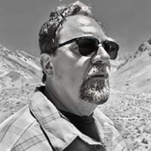
Harrison Campbell with mountains in backgroundAlso an adventurer, Harry enjoyed traveling the world. He explored Indonesia, swam the oceans of Nicaragua, walked the streets of Buenos Aires, hiked the mountains of Argentina, and explored the high desert plains of Colorado. He visited many national parks, here and abroad, sharing a love of nature and the outdoors with his wife and best friend, Terry. He sought to learn about these places and was an active observer and researcher, never forfeiting a chance to gain insight or perspective about how our planet and its people work.
At home he enjoyed quiet mornings sipping coffee on the porch, watching birds at the feeder, and laughing at the Sunday comics. As much bad news as there was around, Harry always made space for jokes; there was always room to squeeze in a zinger.

Baseball was a special pastime for Harry. Whether watching from home or going to minor league or professional games — counting strikes and hoping for homeruns never got old. One of his favorite pastimes was going to Charlotte Knights games with his good friend and colleague, Bill Graves.

Husband, brother, son, stepfather, friend, professor, traveler, thinker, enjoyer-of-life, Harry brought smiles to our world, and he will be missed dearly by many.


Published with permission from Terry Albanese.

    Share

Natasha Rivers

Geography wasn’t the only major Natasha Rivers had in mind. In fact, it wasn’t even her first choice. “I originally thought I was going to study business or become a veterinarian,” she explains. It was a course on globalization that caught her attention, however, where for the first time she really learned about the core periphery of inequality and relative inequality in America. “I was interested in the people I was learning about, not just why they move and transform places that they inhabit, but the history of these people. What’s the language with the culture? What culture do they have to get rid of in order to assimilate?”

Understanding the interconnectedness of people and places has stuck with Natasha throughout her education and into her career. “It’s like, oh, okay, we’re all connected. It’s all relative,” she says. She continues on, emphasizing to this point. “But also, what can we do?”

How to create opportunity after getting a foot in the door

Natasha’s current position is the Sustainability and Measurement Director at BECU, a not-for-profit credit union, having worked her way up after originally being hired as a Program Manager. This original position initially entailed calculating the company’s carbon footprint, but that was where the environmental sustainability responsibilities ended. She quickly realized that there were so many other opportunities associated with the role, whether through expanded staff collaborations or providing members with resources. By asking questions, assessing what was needed and what was possible, while also not being afraid to make recommendations, Natasha elevated her role and presence within the organization.

How does geography play a role in your current position?

“Geography gave me a good idea of understanding people and places, of understanding the natural environment and the built environment. I’m thinking about all of these systems and how they play together with the economy. When thinking about our members, I asked for their demographics. Can we understand more about their race, education, background so that we can really deal with those different segments of the population that might need more resources or financial education?”

Using an understanding of spatial relationships to create effective initiatives in the workplace

What’s been a constant is the importance of understanding people in places. Natasha gives the example of Seattle, a place that has experienced a lot of change and growth in recent years. As a native of the city, she’s seen how the dot com and tech booms have impacted the region. “I grew up in Seattle. But Seattle’s unaffordable for most of the people in my family. So, a lot of them live in South King County.”

This diasporic movement impacts not just Natasha’s own family but the members at BECU. With her background in geography, she’s asking important questions about forced versus chosen migration and seeking answers about why and how people congregate in certain enclaves. By doing so she can better provide short- and long-term sustainability and financial health initiatives that educate members as well as staff on the connection between environmental sustainability and a financial institution.

What was your educational path? What did you study?

Natasha’s geography journey began at the University of Washington, where she double majored in Geography and American Ethnic Studies with a focus on Gender Studies. She continued on to get her PhD in Geography from University of California Los Angeles, where she built upon her interest in demography, followed by two post-docs, one at the University of Minnesota Population Center and the other at University of Washington.

“I had goals of just being an academic, publishing papers, teaching, going to conferences,” Natasha says. “That was my actual first goal. But there wasn’t a lot of opportunity at the time. This was 2010, so our country was still in the process of recovering from the Great Recession of 2008 and jobs were limited.”

If I get a Ph.D., I have to stay in academia? Right?

“So, I have this Ph.D. and it has not worked out for me and I need to figure out what my transferable skills are. I need to tap into my network and luckily my connections at the University of Washington introduced me to someone at the Seattle School District. They had just opened a new role, a Demographer role, and that was exactly my track in undergrad, grad, and my postdoc as well.”

But moving into industry from a perceived career in academia is a difficult transition. “I had to accept that and then adjust,” says Natasha. “That was the biggest adjustment: it was realizing I’m not going to have this current path, so what else is out there for me.”

How does one transition out of academia and into industry?

The key to transitioning out of academia was investing in her own professional development. Natasha had been networking for years with others in her community, from volunteering on boards to working with nonprofits, and she learned how to market herself in a non-academic way by speaking their language. Humility also played a big role in this transition. “I think a lot of times people with PhDs might go into industry and think they should be director right away or VP because of what they’ve achieved in the academic space. But I think it’s humbling to go in as a project or program manager and work your way up.”

What is your favorite part about where you work and what you do currently?

In Natasha’s current role, her favorite aspect of the job is getting to be curious and innovative. “There was no blueprint, this role was the first of its kind,” she explains. “I’m trusted to create these initiatives and do a lot of research, see what other people are doing.”

How Natasha came to work at BECU is a valuable lesson for all of us. Her previous position as a Demographer with the Seattle School District offered no opportunity for growth, and while it served her for a while, there came a time when she felt like she needed to do something more.

“A valued member of my expanded network had an opening at BECU and she had opened the role of Sustainability and Measurement,” Natasha says. “I didn’t think a financial institution would need someone thinking about the environment or sustainability. I could totally do that! So, I went for it, and I got the job.”

How does geography and its components impact not just your professional life, but your personal life?

Geography is more than a profession for Natasha, it factors into her day-to-day life as well. “There’s always the question of why was this made, or where? Where is this coming from? There are different languages being spoken here. I wonder where they came from, or what’s their journey to the U.S. It keeps me alert. It keeps me connected. It keeps me curious.”

One example came from a recent snowstorm in the Seattle area earlier this year. “Our trash wasn’t picked up for two weeks and the trash guys went on strike. So, we got these automated calls about where you can drop your trash off, but most people didn’t know where it was, even though it might be a block or two blocks from their house. Once your trash is picked up, you don’t think about it. You don’t think about where it’s going or how it’s taken care of. You just put your bin out. But when you have to take your bin TO the trash, you see all the trash there.

“I think that is what is so fascinating to me, that there are two types of people: ones that ask questions and people who don’t. Some people just want their trash picked up. But there’s others that think about the impact on the environment or how their trash is being disposed of.”

What advice do you have for geography students and early career professionals?

“Learn a lot from people, learn what you can. Don’t have such a strict view of your life, or what your career is going to look like. Be open. Keep your heart open as well. This life does surprise you, and there’s new roles that will fit exactly what you’re looking for.

“I do think that geography is relevant today, just as it was yesterday, and will be, so don’t be discouraged. There’s so much to do, so much work to be done.”

    Share

AAG Welcomes Spring 2023 Interns

Two new interns have joined the AAG staff this semester! The AAG would like to welcome Iman and Allison to the organization.

Photo of Iman SmithIman Smith is a junior at the University of Maryland, pursuing a B.S. in Geographical Sciences and a minor in Geographic Information Systems. Her areas of interest include agricultural monitoring and crop management, and global food security. In her spare time, Iman likes to travel, crochet, make pottery, and she also hosts a college radio show.

Photo of Allison RiveraAllison Rivera is a senior at the University of Connecticut pursuing a B.S. in Geoscience and a minor in Geography. She is mostly interested in geomorphology and physical geography and is currently completing a senior thesis on such topics. After graduation, Allison hopes to attend graduate school and pursue further research in the field of geomorphology. In her spare time, she enjoys watching cartoons, going for walks, and reading.
If you or someone you know is interested in applying for an internship at the AAG, the AAG seeks interns on a year-round basis for the spring, summer, and fall semesters.

Learn more about becoming an AAG intern
    Share

AAG Letter to Members on the Forces that Shape Police Brutality

    Share

Gerry A. Hale

Gerry Hale, a long-time, much-loved professor in the Department of Geography at the University of California, Los Angeles, died on October 14, 2022.

Born in 1933 in Los Angeles, Gerry (pronounced “Gary”) was raised in the neighboring city of Glendale. He attended UCLA as both an undergraduate and graduate student. In the early 1960s, while conducting fieldwork in Sudan, Gerry served as the Head Geography Master at Unity High School for Girls in Khartoum and as a Visiting Lecturer at the University of Khartoum. Before and after his time in Sudan, he also taught at the University of Southern California. In 1966, working under the direction of Dr. Joseph Spencer, he completed his Ph.D. dissertation on agricultural terracing in Sudan’s Darfur region. Soon thereafter, he joined the UCLA Department of Geography as a tenure-track faculty member.

A political and cultural geographer, Gerry’s teaching and research focused on technology, nationalism, the state, cultural hegemony, capitalism, anti-colonialism and empire, and Marxist geography. His regional specializations were in North Africa, the Middle East, and California.

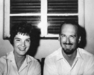
Photo of Sondra and Gerry Hale in their house in Hai el-Matar, Khartoum, Sudan, 1961.Photographer: unknown.
Sondra and Gerry Hale in their house in Hai el-Matar, Khartoum, Sudan, 1961. Photographer: unknown.

A combination of factors—ranging from witnessing pervasive racial injustice in Glendale and exposure to the early years of postcolonial life in Lebanon (where he studied as a M.A. student) and in Africa, to the horrors of the U.S. war in Vietnam—radicalized Gerry. By the late 1960s, he saw himself as Marxist—politically as well as intellectually.

Consistent with his politics—a combination of democratic socialism, feminism, and anti-racism—Gerry was involved in Antipode: A Radical Journal of Geography from its initial days. As the journal’s structure became more formalized, he served on the editorial board from 1978 to 1985.

Gerry’s politics also underlay his intense dedication to students. He was the advisor to approximately a dozen Ph.D. students who went on to academic careers, and to scores of Master’s students—in Geography as well as in the African Studies M.A. Program, for which he served as director for some years, and in the Center for Near Eastern Studies. He was also the Department of Geography’s undergraduate and graduate advisor during the 1990s. In these roles Gerry was known to be a strong supporter of women faculty and students.

Because of his politics, life at UCLA in Gerry’s earlier years as a faculty member were often difficult given the strongly conservative ethos that permeated the institution. Changing times and, more importantly, Gerry’s generous spirit, ethical character, collegiality, and dedication as a teacher of undergraduate and graduates alike eventually won over most, if not all, of his detractors. By the time of his retirement circa 1997, Gerry was a highly valued and universally appreciated citizen of the Department and the University as a whole; he was a member of some of the most prestigious bodies on campus, such as the Committee on Privilege and Tenure.

A strong sense of justice motivated much of what Gerry Hale did as a geographer. Many of those who were fortunate enough to take an undergraduate course with him, for example, learned about what happened to the predominately working class and Mexican-descended community of Chavez Ravine. Beginning in 1951, the City of Los Angeles used eminent domain to expel the area’s residents and raze their homes—in the name of public housing which never arrived. Instead, years later, the city sold the land to the Los Angeles Dodgers to build a baseball stadium.

As one former student, now a historian, recalled in relation to Gerry’s telling of the story, “When I was growing up in Echo Park (a Los Angeles neighborhood), I didn’t know this history. I don’t think most people know it today. I learned it once I got to UCLA, in a geography class with Gerry Hale. He was not even a Chicano, but a white man who engaged in a one-man boycott of Dodger Stadium, having made a personal commitment to never go to ballgames because of what had happened on the land on which Dodger Stadium sits.”

Gerry Hale is survived by his longtime partner, Sondra Hale, professor emeritus of Anthropology and Gender Studies at UCLA, and their daughters, Alexa and Adrienne, as well as by countless others whose lives he touched.


Provided by Garth Myers (Trinity College) and Joseph Nevins (Vassar College).


    Share

On the Structural and Spatial Forces that Contribute to Police Brutality 

Photograph entitled "Volunteer Bridge" by Tyre Nichols; the image shows the Hernando De Soto Bridge lit up in the evening in Memphis, Tennessee
Photograph entitled "Volunteer Bridge" by Tyre Nichols

The systemic forces and spatial conditions that shape police brutality, especially against Black people, are well documented by researchers in many disciplines, including geography.

In 2022, at least 1,192 people were killed by law enforcement officers in the U.S., the most of any year since at least 2013 (Mapping Police Violence project). As geographer, Rashad Shabazz has written, “Policing in the U.S. has, from its inception, treated Black people as domestic enemies.”

AAG is providing a resource list that brings together work by geographers and colleagues in other disciplines to illuminate how “police and policing [are] a multifaceted manifestation of state power, coercion, and territoriality” (Bloch, 2021). AAG members are committed to studying and working to change these structural issues in their work and lived experiences. Our list of resources is drawn in part from the list curated by the AAG Black Geographies Specialty Group. We also have created a list of Black Geographies articles from AAG journals, available with free access through December 2023.

  • Bledsoe, A. , Butler, J., Eaves, L., Moulton, A. A. (2023). A Syllabus for the Present Predicament. Google doc, February 2023.
  • Bloch, S. (2021). Police and policing in geography: From methods, to theory, to praxis. Geography Compass, March 2021, 15,3. https://doi.org/10.1111/gec3.12555
  • Bloch, S. (2021) Aversive racism and community-instigated policing: The spatial politics of Nextdoor. Environment and Planning C: Politics and Space, 10.1177/23996544211019754, 40, 1, (260-278).
  • Carby, H (1992). “Policing the Black Woman’s Body in an Urban Context.” Critical Inquiry 18: 739–55.
  • Correia, D. and Wall, T. Police: A Field Guide (2022)
  • Hamilton, A.R. & Foote, K. (2018) Police Torture in Chicago: Theorizing Violence and Social Justice in a Racialized City, Annals of the American Association of Geographers, 108:2, 399-410, DOI: 10.1080/24694452.2017.1402671
  • Herbert, S. (1996) The Normative Ordering of Police Territoriality: Making and Marking Space with the Los Angeles Police Department, Annals of the Association of American Geographers, 86:3, 567-582, DOI: 10.1111/j.1467-8306.1996.tb01767.x
  • Jackson, A.N. (2022) “The More Things Change, the More They Stay the Same: A Spatial Analysis of Historical and Contemporary Incidents of Police Violence”, Leitz, L. (Ed.) Race and Space (Research in Social Movements, Conflicts and Change, Vol. 46), Emerald Publishing Limited, Bingley, pp. 65-86. ResearchGate open access
  • Pauschinger, D. (2020). Working at the edge: Police, emotions and space in Rio de Janeiro. Environment and Planning D: Society and Space, 38(3), 510–527.  https://doi.org/10.1177/23996544211019754
  • Ramírez, M. M. (2020). City as borderland: Gentrification and the policing of Black and Latinx geographies in Oakland. Environment and Planning D: Society and Space, 38(1), 147–166. https://doi.org/10.1177/0263775819843
  • Radil, S. M., Dezzani, R. J., & McAden, L. D. (2017). Geographies of US police militarization and the role of the 1033 program. The Professional Geographer, 69(2), 203–213. https://doi.org/10.1080/00330124.2016.1212666
  • Rios. J. (2020). Black Lives and Spatial Matters: Policing Blackness and Practicing Freedom in Suburban St. Louis. Ithaca: Cornell University Press.
  • Saunders, R. H. (1999b). The politics and practice of community policing in Boston. Urban Geography, 20(5), 461–482. https://doi.org/10.2747/0272-3638.20.5.461
  • Smith, S. J. (1986). Police accountability and local democracy. Area.18(2), 99–107.  https://www.jstor.org/stable/20002310
  • Tulumello, S. & Iapaolo, Fabio (2022). Policing the future, disrupting urban policy today. Predictive policing, smart city, and urban policy in Memphis (TN), Urban Geography, 43:3, 448-469, https://doi.org/10.1080/02723638.2021.1887634
  • van Stapele, N. (2020). Police killings and the vicissitudes of borders and bounding orders in Mathare, Nairobi. Environment and Planning D: Society and Space, 38(3), 417–435. https://doi.org/10.1177/0263775819884
  • Vigneswaran, D. (2014). The contours of disorder: Crime maps and territorial policing in South Africa. Environment and Planning D: Society and Space, 32(1), 91–107.  https://doi.org/10.1068/d18311
  • Vitale, A. S. (2005). Innovation and institutionalization: Factors in the development of “Quality of Life” policing in New York City. Policing and Society, 15(2), 99–124.  https://doi.org/10.1080/10439460500071754
  • Wall, T., & Linnemann, T. (2014). Staring down the state: Police power, visual economies, and the “war on cameras”. Crime, Media, Culture, 10(2), 133-149. https://doi.org/10.1177/174165901453142
  • Woods, Clyde (2002). Life After Death. The Professional Geographer, Volume 54, Issue 1. https://doi.org/10.1111/0033-0124.00315
  • Yarwood, R. (2007). The geographies of policing. Progress in Human Geography, 31(4), 447–465. https://doi.org/10.1177/03091325070795
  • Yarwood, R., & Paasche, T. (2015). The relational geographies of policing and security. Geography Compass, 9(6), 362–370. https://doi.org/10.1111/gec3.12216
Further Reading

See more at AAG’s list of free-access articles on Black Geographies from our journals

    Share

On the Map: Denver’s Five Points and Whittier neighborhoods

Image of Robinson Atlas of the City of Denver (Plate 12). Source: Denver Public Library, Special Collections

By Sam Hinton with Lisa Schamess

Northeast of downtown Denver, the Five Points and Whittier neighborhoods are among the city’s oldest, the first to extend beyond Denver’s original Congressional Grant. As a longstanding center for African American life in Denver, as well as a hub for the Chicano Movement, these neighborhoods are a vital location in the city.  

Five Points starts at 17th and Downing on the east edge and extends north along Downing to 38th Street. The Whittier neighborhood is less extensive, starting at 23rd and Downing Street and extending north until East Martin King, Jr. Boulevard. Established in the 1870s, Five Points was named after Denver’s diagonal downtown grid with a rectangular suburban grid, which meet at Washington Street, 27th Street, 26th Avenue, and Welton Street. Whittier Elementary School was named in honor of John Greenleaf Whittier (1807-1892), an American poet and abolitionist. 

The neighborhoods were and still are today dynamic and multi-cultural places. Many Latinx-Americans and Asian Americans work and reside in the area. While it was always historically a home to African Americans, increasing segregation in the 1920s resulted in more than 90% of Denver’s African American residents living in Five Points or Whittier during the mid-20th century.  

Throughout the 1930s, 40s, and 50s, the area was also a significant cultural and entertainment destination. The area is home to Denver’s first urban park, Colorado’s oldest Black church, and Temple Emanuel, one of the state’s oldest synagogues. Jazz also runs strongly through Five Points and Whittier’s narrative. Sometimes called the “Harlem of the West,” the area was a popular stop for jazz stars like Billie Holiday, Louis Armstrong and Miles Davis. They played clubs like the Rossonian and the Rainbow Room, and Benny Hooper’s hotel. Today, the annual Five Points Jazz Festival and Juneteenth Music Festival are renowned.  

The neighborhoods have a rich entrepreneurial history. For example, the Niederhut Carriage Company was a family-run business by brothers Henry and William Niederhut for a century, and one of the largest transportation manufacturing companies in Denver.  

In 1920, Dr. Clarence Holmes founded a dental practice at 2602 Welton Street and was the first African American to join the Denver Dental Society. A graduate of Howard University in Washington, DC, he otherwise lived his entire life in Denver. He was born to a family that valued civic responsibility: his mother Mary Holmes was the first African American woman to run for the state legislature. Dr. Holmes helped found the Colorado-Wyoming branch of the National Association for the Advancement of Colored People (NAACP). His early years as the first Black dentist in Denver were “rough,” he said in 1973, with obstacles put in his path by segregation, individual racism and intimidation, and white supremacist forces in professional societies and businesses serving dentists. Hear Dr. Holmes offer his oral history to the Denver Public Library in 1973 (Content Warning: frank use of racist terminology). 

Reverend David West Mallard owned multiple businesses including Mallard’s Grocery and Confectionery. Other notable businesses included Rice’s Tap Room and Oven, The Rhythm Records and Sporting Goods Shop, the American Woodmen’s Insurance Company, and Melvina’s Beauty Shop. 


Photo of Niederhut Carriage Company circa 1900; credit Denver Public Library Special Collections
Niederhut Carriage Company circa 1900. Credit: Denver Public Library Special Collections


Photo of David and Virginia Mallard in front of their store, circa 1948, with an unidentified man. Credit: Denver Public Library Special Collections
David and Virginia Mallard in front of their store, circa 1948, with an unidentified man. Credit: Denver Public Library Special Collections


Today, many descendants of the original Black residents no longer live in Five Points. Efforts to bring new life to the community have included a new urban rail line and the renovation of the Rossonian Hotel. These changes, however, have also accelerated gentrification, Nonetheless, the Five Points and Whittier remain an important touchpoint for Black and Latinx communities. The neighborhoods host many artists and are the center of several lively mural projects depicting their history and culture, such as La Serpienta Dorada and the Five Points Mural Gallery.  


Photo of Artist Brian Doss at the annual Jazz Festival in Five Points. Credit: Kent Kanuse, Flickr.
Artist Brian Doss at the annual Jazz Festival in Five Points. Credit: Kent Kanuse, Flickr.


Learn more: 

The neighborhood Business Improvement District hosts a self-guided, self-paced walking tour of Five Points. Five Points Plus is a museum and online exhibit that showcases the human stories and collective memory of living, working, and growing up in Five Points. Developed in partnership with the Black American West Museum and Heritage Center along with Five Points community members and supported by the Blair-Caldwell African American Research Library (Denver Public Library) and Manual Highschool. Prepare for your visit by finding out about the Black-owned and other businesses in the area. 

This article was prepared using sources from Denver.org and the Denver Public Library 

DOI: 10.14433/2017.0126

    Share