Jean-Bernard Racine

Professor Emeritus at the University of Lausanne in Switzerland, Jean-Bernard Racine passed away on March 23, 2026. He was renowned for bridging European and Anglo-American geographical traditions, playing a key role in introducing New Geography to the French-speaking academic world. He received the Vautrin Lud Prize in Geography in 1997.

Born into a Protestant family in Neuchâtel, Switzerland, Racine earned his undergraduate degree in Geography from the University of Aix-en-Provence in France in 1962. He obtained his doctorate in Geography from the same university in 1965 under the supervision of Hildebert Isnard. Inspired by regional geography, Racine coined the term “peri-urban” to describe land changes in Southern France in the late 1960s.

Following a trip to Quebec in 1965, Racine was appointed assistant professor in the Department of Geography at the University of Sherbrooke, which he headed from 1966 to 1969. In 1969, he was appointed associate professor at the University of Ottawa in Canada. His office was next to that of Stanley Gregory, a pioneer in the application of statistical methods to geography.

After his postdoctoral proposal was criticized for its lack of formal rigor, Racine embarked on a tour of American and Canadian universities, meeting Allen J. Scott at UCLA, Larry Bourne (one of his many “great friends”) and Bryn Greer-Wooten in Toronto, David Lowenthal and Alan Pred at Berkeley, and, most importantly, Brian Berry in Chicago, whose work on city networks he would admire for the rest of his life.

While in North America, Racine developed a long-lasting relationship with William (Bill) Bunge, with whom he shared a common interest first for theoretical geography, and later on for social justice and critical analysis of spatial structures. They stayed in touch regularly (and always by phone “for fear of being spied on by the CIA”) until the early 2000s.

Deeply committed to understanding how cities emerge and evolve, Racine shaped the field of urban geography by employing the statistical tools brought to the fore by the New Geography. The guidelines of this “revolution” were formalized in a small but influential book entitled “Quantitative Analysis in Geography” (L’Analyse Quantitative en Géographie) published in 1973 with Henri Reymond. Using Brian Berry’s statistical software, Racine applied quantitative analysis in his monumental second doctoral dissertation, devoted to the peri-urban growth of Greater Montreal in 1975.

At the age of just 33, Racine returned to Switzerland, where he served as director of the Institute of Geography at the University of Lausanne (UNIL) from 1973 to 1982. He was appointed associate professor and later full professor in the Faculty of Arts and at the School of Business and Economics (HEC), where he taught numerous courses in economic geography and epistemology. Racine was a brilliant speaker with a powerful voice that captivated his audience. At UNIL, he served as vice-dean (1980–1982) and dean (1982–1984) of the Faculty of Arts, before resuming the directorship of the Institute from 1986 to 1992 and from 2000 to 2004. He retired as professor emeritus in 2007.

Racine was one of the most influential figures in Francophone geography over the past fifty years. While he is mainly known for having imported quantitative geography from North American to Europe in the 1970s, his most enduring contribution to science is in theoretical geography. Less interested in techniques than in the questions that geography can help to formulate, Racine contributed to the renewal of geographical epistemology, often with other key Francophone geographers.

In 1981, he published “Geographical Questions” (Problématiques de la géographie) with Hildebert Isnard and Henri Reymond, a book that examined the questions that geographers face and how to approach them systematically. Racine published extensively with Claude Raffestin from the University of Geneva, who died in 2025, and with Antoine Bailly, another geographer who returned to Switzerland after living in Canada.

Racine played a decisive role in the culturalist turn that swept through the social sciences beginning in the 1980s. Like many other geographers, his shift toward cultural geography was inspired by the writings of David Ley, Anne Buttimer, Yi-Fu Tuan and, of course, David Harvey, whose book The Condition of Postmodernity was prominently displayed in his Lausanne office.

The son of a pastor, Racine’s approach was deeply rooted in a humanist tradition, which is reflected in a wealth of publications co-authored with his doctoral students, such as Antonio Cunha, Ola Söderström, Etienne Piguet, and Lorenza Mondada. Published in 1993, The City Between God and Man (La Ville entre Dieu et les Hommes) is undoubtedly the book that best combines his deep interest for urban transformation and religious faith.

In the ten years leading up to his retirement in 2007, Racine turned his attention to urban issues, particularly that of Lausanne, a city for which he had a deep passion. Far from resting on its laurels, and always surrounded by many young researchers, he threw himself with seemingly inexhaustible energy into the study of the city’s “fragile” or marginalized users. His humanistic approach to geography, attentive to the voices of young people, people with disabilities, and migrants, anticipates the most recent work in our discipline.

Internationally, Racine served as vice-chair of the International Geographical Union’s Commission on Urban Development and Urban Life from 1992 to 2000. He worked closely with or in parallel to influential French geographers such as Paul Claval, Sylvie Rimbert, René Dumont, Jean Labasse, Pierre Georges, Roger Brunet, and Denise Pumain. He played a leading role in the Dupont Group, founded in 1971 to introduce theoretical and quantitative geography in France, and in the organization of the Géopoint conferences beginning in 1976.

The author of four major books and 250 articles, Racine served as co-editor of Geographica Helvetica for many years and was a member of the editorial board of L’Espace géographique, Géographie et Cultures, and Articulo-Journal of Urban Research, founded by his doctoral students in 2005.

Racine’s influence on modern geography is evident in his ability to bring together geographers from remarkably diverse backgrounds. Based in Quebec and Switzerland, he managed to occupy a central position in our discipline without being located at its geographical center.

One of his most enduring contributions is having mentored two generations of geographers, all of whom, with rare exceptions, hold academic positions in Switzerland, Europe, and the United States. Racine tirelessly devoted his extraordinary intellect to the ideas that underpin modern geography. With his passing, we have lost one of the greatest brokers of Francophone geography.


Written by Olivier Walther
    Share

Member Profile: Dydia DeLyser

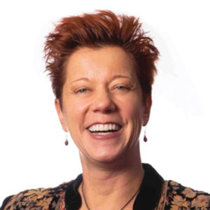
Photo of Dydia DeLeyser“Figuring out what places are about” is the foundation of Dydia DeLyser’s inquisitive, hands-on work to explore and preserve American landscapes and cultural histories. A professor of geography emerita at Cal State Fullerton, DeLyser has cultivated this outlook from early on. As the child of Dutch immigrants who came to the U.S. in the 1960s, she learned early how place, belonging, and language could open—or close—doors.

“My first language is not English, it was Dutch,” she says. “So my earliest memories are of having sort of a secret language at home that nobody else could understand.” Her parents were “always trying to understand American culture, and yet never able to become a part [of it].”

For DeLyser, the outsider status was doubled by another kind of “outside:” the past. Her parents’ vivid stories of their experiences of World War II and the privations of life in Europe even before Nazi occupation lit up DeLyser’s imagination and appreciation for social history: “The broader cultural stories about our past, like my parents’ stories about the war, are also intimate personal stories that happen in the lives of individuals,” she says. “We connect our individual experiences to the broader narrative, you know, of victory over the Nazis or so many other issues. That’s a geographical or spatial experience.”

DeLyser’s hunger to understand and embrace places and times she couldn’t know firsthand have led to her foundational preoccupation with what she calls “the intimate geographies of social memory.”

Bridging Time and Space

DeLyser started working on her intertwined study of history’s large scales and intimate personal histories while she was still an undergraduate at UCLA, aided by her work at UCLA Library’s Department of Special Collections in the manuscript, photographs, and rare books library, one of the largest such departments in the country. The archive housed the personal papers of L.A. notables and international figures such as novelist Raymond Chandler, journalist Carey McWilliams, writers Henry Miller and Anaïs Nin, and Peggy Hamilton, the first fashion editor of the LA Times.

Reading their letters and manuscripts opened DeLyser’s eyes to new ways of knowing people, even after their deaths. Research—specifically, qualitative research with primary materials—was like a portal through the gap in time and place that had so fascinated and frustrated DeLyser from childhood. She has dedicated her career to the methods that make qualitative research vibrant.

“To me, scholarship should be empirically rich, grounded in some real thing,” she says. “It should be theoretically sophisticated and engaged with whatever conceptual conversations are current and engaging and relevant in the discipline or subdiscipline you are in, and it should be methodologically articulate.” Put simply, she says: “You should be clear how you know.”

DeLyser describes research methods as “an important form of credibility for a scholar, as the core of your scholarly credibility. If you can show how you know—because you interviewed these people or because these are the quotes or because you did this archival research or you spent ten years observing at this place or because you actually did the labor or whatever the reason—If you can show how you know, then we will trust you. And then we’ll be able to learn from you, we’ll be able to take on whatever your point is.”

If you can show how you know, then we will trust you.”

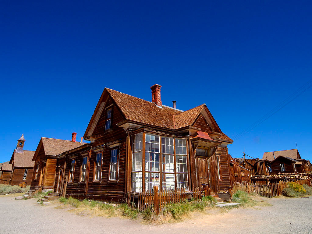
Early in her career, DeLyser established a close relationship to Bodie, a California ghost town in the Eastern Sierra region. Designated a National Historic Landmark and state park in the early1 960s, Bodie began as a gold-mining town that boomed in the 1870s, crashed in the 1880s, but then lingered well into the 20th century. As the population declined, at one point there were more buildings than people. And as residents left, they abandoned furnishings and things they didn’t want to pay to move, which became the  intact artifacts of their daily lives on display in about 200 buildings, from dishes, pots, and chairs in kitchens to unused caskets in the town morgue.

Exterior view of a building in Bodie, Calif. Credit: Jon Sullivan, Wikimedia Commons
Credit: Jon Sullivan, Wikimedia Commons


Starting when she was a college student with summers free, she began working as a low-paid, unskilled seasonal worker for maintenance, DeLyser gradually deepened her knowledge of Bodie over the next 35 years in all different ways, from conducting ethnographic research tourists there to using the Park’s own archive to understand how State Parks staff were themselves shaping what visitors saw and ultimately to using her research to make the case for broadening the town’s National Historic Landmark status, all while putting in true sweat equity in caring for the town, from physically working to stabilize the abandoned buildings to “cleaning about 10,000 [public] toilets.” Now, she is executive director of the town’s nonprofit, working to preserve Bodie in a state of “arrested decay—keeping the buildings standing while letting them look like they’re still falling down,” according to DeLyser. Today’s visitors to Bodie can peer inside its buildings to see the many personal items left behind by the final occupants, and imagine the lives of the town’s former inhabitants. DeLyser was interested in the impact of this on visitors, especially in the moments of recognition when a specific object reminded them of something in their own lives. DeLyser then sought to map these personal epiphanies onto the larger stories of history.

Interior view of a kitchen in Bodie, Calif. Credit: Fronl, Wikimedia Commons
Credit: Fronl, Wikimedia Commons


“Ghost towns are so connected to the mythic West in the United States, to the heroic, mythologized tales of the “Wild West” and all that, we simply connect ourselves to big themes about American culture. All of a sudden, from a small life and a small object, it links to the big themes. I’ve seen myself have ordinary objects spark magic in my life many times, and I’ve studied how it happens.“

Always say yes

DeLyser also engages enthusiastically as a teacher, mentor, and champion of the geography discipline. Over the years, she has served on AAG Council, was a founding member of the AAG Qualitative Research Specialty Group, contributed to the work of the AAG Harassment Free Task Force, as well as its Public and Engaged Scholarship Task Force. She worked tirelessly during the COVID pandemic to deliver supportive programming for graduate students, and also serves on the AAG Climate Committee, to name only a few contributions. It’s part of her commitment to hold the door open for the next generation of geographers.

“I’ve had to bust open doors myself in my career, but the point isn’t about busting open doors. The point is to hold the door open and create a pathway for success for the people who will come after us,” she says.

She brings the same esprit de corps to her research and publishing. “There’s no sense in scholarship unless it’s shared,” she says. “If I can learn something from my scholarship about the past, I feel obligated to share that, otherwise I take it with me. It happens in the moment, it happens in the present, but it’s always for the future.”

Living in Bodie, where only Park staff now live, gave DeLyser a strong sense of community, and a strong desire to give back to that community, something that has followed her throughout her career.

DeLyser is careful to appreciate and credit the communities she works with. Years later, as she launched a new research project about how neon signs have shaped the American landscape she recognized that there was a “neon community” or “communities” in the U.S., and, she says, “I wanted people to feel like they knew who I was and they welcomed my work, so it took me a long time to become part of that community, vested in being part of a community as ‘neon people.’” DeLyser says neon signs are “an incredibly overlooked part of the American landscape. People read the sign that says “OPEN” over the door that’s red and blue—they read that sign without even realizing that they’ve read it.” She wanted to bring those hidden signs and their hidden stories to light.

DeLyser had been introduced to the behind-the-scenes world of neon by her husband and longtime creative partner, Paul Greenstein, an expert in the history and repair of classic neon signs. Early in their relationship, she accompanied him to repair a sign over a restaurant, and the adventure sparked questions and conversations, which in turn led to more than a half dozen collaborations over the years. Greenstein and DeLyser have delved into the history and cultural significance of neon, antique cars, and Indian motorcycles. Their 2021 book Neon: A Light History  is the latest culmination of these collaborations.

DeLyser’s approach to research combines immersion in the topic, becoming embedded in the communities that hold deep knowledge about it. She sees her research across a spectrum of often deeply personal and committed hands-on experience and careful methodologies. “I had all the tools,” she recalls of her long relationship with Bodie. “I knew how to use a hammer and a Skilsaw, and I also I knew how to do an interview. I had a hammer in one hand and a notebook in my pocket.”

    Share

Beyond the Tourist Gaze: Power, Place, and Organizing in San Francisco Chinatown

The Hills of San Francisco

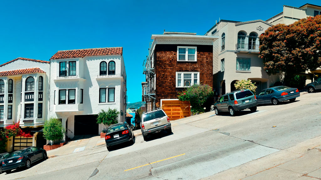
Street hill gradient showing homes built on a slope with cars parked on the deeply slanted street.
Street hill gradient in San Francisco

Unlike the rest of California, San Francisco has a unique geography that shapes its weather and settlement patterns. The city is set on the tip of a peninsula halfway up the coast of northern California, surrounded by bodies of water on three of its sides: the Pacific Ocean, the Golden Gate strait, and the San Francisco Bay. The city is laid out over hills that stretch from coast to coast, reaching heights of nearly 1,000 feet, making the climate similar to coastal areas on the Mediterranean.

The hills of San Francisco define its topography and culture. It’s hard to pinpoint the exact number in the city, but many sources consider there to be more than 50 named hills. As Pulitzer Prize-winning San Francisco Chronicle columnist Herb Caen notes in his introduction to the Hills of San Francisco, no one can quite agree on which [hills]. Although it’s debated among locals, there are seven hills that are iconic to the city: Russian Hill, Nob Hill, Telegraph Hill, Twin Peaks, Mount Davidson, Mount Sutro, and Rincon Hill.

So, when is a hill a hill? Self-proclaimed San Francisco explorer Dave Schweisguth claims, “When it’s a lone mountain. That is, if you can walk all the way around it, always looking up to its summit. It’s not so clear cut when hills run together into a ridge, which most of San Francisco’s do. Height alone is not so important: a very small hill may be perfectly obvious, while a string of higher summits may be hard to tell one from the next. It’s easier to call a hill a hill if it’s separated from its neighbors — if, on a topographic map, a contour line or two traces all the way around its summit.”

The Range of Iconography

Originally named Blue Mountain for the wildflowers that cover the hillside, the city’s tallest hill was renamed Mt. Davidson at the urging of the Sierra Club in 1911, after George Davidson, the geographer who surveyed it. It is the focal point of San Francisco’s Mt. Davidson Park, with a forest that accounts for more than 30 of the park’s acres, quietly remaining an oasis in the most densely settled city in California. Defined by a 100-foot cross at its peak, Mount Davidson stands at an elevation of 928 feet. Urban hikers share that despite how small the overall area is, the trails aren’t consistently marked, which causes explorers to get lost in the woods.

Hikers also recommend Mount Sutro, located in central San Francisco, for its role in the city’s cultural and natural history. Its century-old trails are now preserved by the University of California, San Francisco, which guides the long-term restoration of the 61 acres and protects the ecological oasis in the heart of the urban environment, along with the citizen group Sutro Stewards. The city’s elevation and abundant summer fog contribute to the mountain’s microclimates and its plant and wildlife communities.


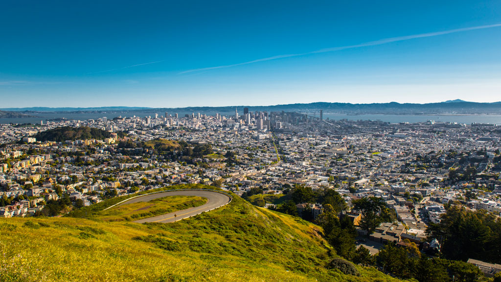
View of San Francisco from Twin Peaks showing the city skyline wrapping around several hills
Twin Peaks view in San Francisco. Credit: optionm, Getty Images


Originally called “Los Pechos de la Choca” (Breasts of the Maiden) by early Spanish settlers, Twin Peaks is a main landmark of San Francisco’s skyline, reaching elevations of 910 and 922 feet. Similar to Mt. Davidson and Mt. Sutro, Twin Peaks hosts a 64-acre park of coastal scrub and grassland communities that offer an idea of how San Francisco’s hills and peaks looked before development changed them forever.

Early in defining San Francisco’s history, Nob Hill, Russian Hill and Telegraph Hill continue to remain among the most popular neighborhoods to visit.


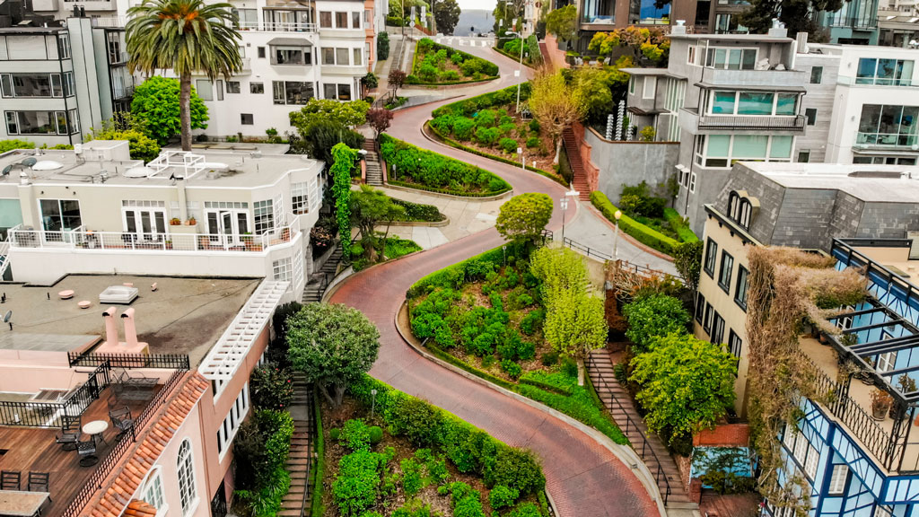
Aerial photo showing the curve of Lombard Street winding down the hill between homes
Lombard street in San Francisco Lockdown. Credit: Tiago Ignowski, Getty Images


Russian Hill’s name dates to 1847 when Russian sailors were buried on the hill during the gold rush in the 1800s. The burial sites are long since deeply covered, and it’s now only possible to admire a plaque at the site where the cemetery once stood. This is the same neighborhood home to the famous Lombard Street, that draws tourists from around the world due to its scenic switchbacks and postcard views. Because the slope in this area reaches 27° (51%), 8 hairpin bends were put in the 1300 feet between Hyde Street and Leavenworth Street to allow cars to drive down the street, ultimately creating one of the most winding streets in the world.

Russian Hill borders Nob Hill to the south, one of the city’s most upscale neighborhoods.  Originally called California Hill (after California Avenue, which runs right over it), Nob Hill got its name from the word “nabob” that originated from the Hindu word meaning a wealthy or powerful person. This affluent neighborhood was home to the Central Pacific Railroad tycoons known as the “Big Four,” who were among the first to build their mansions here.


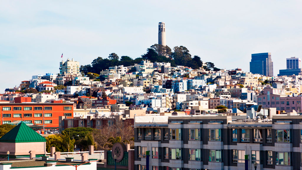
View of Telegraph Hill from below showing buildings and homes rising up to the tower atop the hill.
View up to Telegraph Hill’s Coit Tower. Credit: slobo, Getty Images Signature


Telegraph Hill hosts Coit Tower, an iconic piece of architecture that resembles a fire hose and affords incredible views of the city; its walls are also home to historic artwork. Originally, the Tower was a windmill-like structure created in 1849 to signal ships entering the Golden Gate. Once the trek is completed, the summit provides a breathtaking panoramic view of the city with landmarks like the Golden Gate Bridge, Alcatraz, and the Transamerica Pyramid.

Whether you’re taking a leisurely stroll or hiking the steepest routes, you can recall the words of the iconic San Francisco journalist Herb Caen, who once said, “Take anything from us — our cable cars, our bridges, even our Bay — but leave us our hills.”

You can hit the trails with a guided tour or explore the city on your own. The SF Gate compiled a list of 11 hikes within the city limits that allow visitors and residents to get to know the landscape. An interactive map created by a UC Berkeley graduate student studying urban planning maps SF’s slopes and uses simple color coding to show where the flattest pockets of land are. If you’ll be attending AAG’s 2026 Annual Meeting in San Francisco, you’ll want to bring your walking shoes!

    Share

The Hidden Costs of Commercial Fishing: Sustaining Economies and Ecosystems

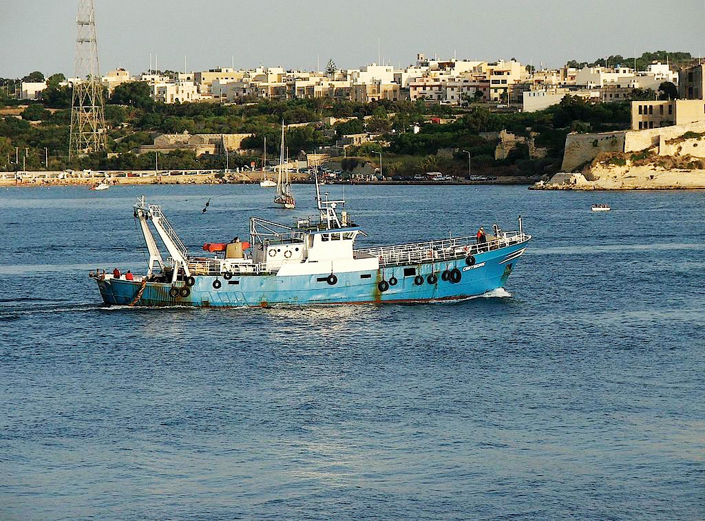
Image of a trawler boat sailing near Malta. Source: Peter Grima

Geography In The News logoGeography in the News is an educational series offered by the American Association of Geographers for teachers and students in all subjects. We include vocabulary, discussion, and assignment ideas at the end of each article. 

By Adeti Afe

Fishing has been a part of human life for thousands of years, helping to feed societies while maintaining a balance in marine ecosystems. Traditional fishing usually keeps fish populations in check. But now, methods for industrial-level commercial fishing can cause serious harm to marine ecosystems. Scientists warn that some of the world’s most important fishing areas and habitats could be permanently damaged due to issues like overfishing, habitat destruction, and the problems caused by aquaculture.

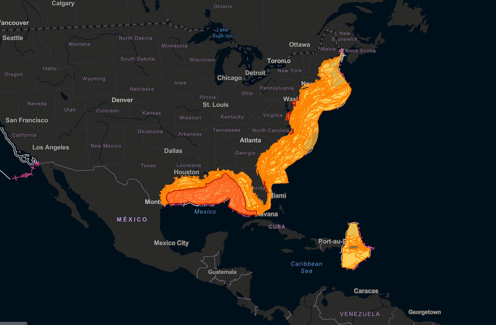
Image of a static map showing fish habitats off the East and Gulf Coasts, as well as in the Caribbean Sea. Credit: NOAA
The National Oceanic and Atmospheric Administration (NOAA) maintains Fishmapper, an interactive mapping tool for examining important habitats for managed fish populations worldwide. Credit: NOAA


Overfishing disrupts the balance of marine life. When certain fish populations decline, predators lose their prey, and smaller fish can overpopulate. This creates even more problems in the ecosystem. Coral reefs, for instance, rely on fish to control the growth of algae. Without enough fish, algae can grow uncontrollably, killing the reef’s ecosystem.

The United Nations’ Food and Agriculture Organization (FAO) reports that more than one-third of global fisheries are overfished. Over the past 50 years, the number of overfished areas has tripled. A major factor contributing to this is bycatch, which is the unintentional capture of animals like sea turtles, dolphins, and sharks in fishing nets. Millions of animals are killed this way each year, adding to the damage in already struggling ecosystems. Sea turtles are often caught unintentionally by getting tangled in nets and are harmed before they can be freed. Similarly, endangered species such as certain whales and dolphins suffer high mortality rates due to poor fishing practices. Bycatch damages the biodiversity necessary for healthy ecosystems.

Image of a trawler boat sailing near Malta. Source: Peter Grima
A trawler in Malta. Trawlers drag nets through the sea, either above the sea floor or along the sea floor. This method of fishing is indiscriminate and has negative impacts on sea ecologies. It is banned in many areas. Source: Peter Grima


The methods used in industrial fishing often cause harm to underwater habitats. Bottom trawling, for example, involves dragging heavy nets along the seafloor. While effective at capturing fish, this practice devastates coral reefs and seagrass beds, which are essential habitats for many marine species.

The Complex World of Fish Farming

To meet the growing global demand for seafood, many businesses have turned to aquaculture, also known as fish farming. On the surface, aquaculture appears to be a solution to overfishing, but it introduces its own set of environmental and ethical concerns. Farmed fish are often raised in overcrowded enclosures, which can lead to water pollution from waste.

Aquaculture relies heavily on fishmeal and fish oil derived from wild-caught fish, which means it continues to put pressure on already overfished stocks. Escaped farmed fish can further disrupt ecosystems by competing with native species for resources or introducing genetic and behavioral differences that harm wild populations.

Finding a Better Way

The negative effects of commercial fishing extend beyond the environment, impacting human communities. Illegal, unreported, and unregulated (IUU) fishing increases the problem. Operating outside the bounds of international and local laws, IUU fishing often targets the waters of vulnerable nations. This practice robs local fishers of their resources and disrupts efforts to maintain sustainable fishing practices.

Several actionable steps can mitigate the damage caused by commercial fishing. Stricter regulations on fish catch limits and the establishment of marine protected areas (MPAs) can help ecosystems recover and maintain biodiversity. MPAs provide safe zones where marine life can thrive without the pressure of fishing.

Technological advancements can also play a role by including selective fishing gear that can reduce bycatch. Consumers can make a difference by choosing sustainably sourced seafood, certified by organizations such as the Marine Stewardship Council (MSC).

Commercial fishing is essential for feeding millions of people around the world, but it comes at a cost. Our oceans, and the communities that depend on them, are under serious pressure from overfishing, habitat destruction, bycatch, and unsustainable fish farming. These practices are pushing marine ecosystems to their breaking point. The good news is that we still have a chance to make a difference. By enforcing smarter regulations, using better technology, and making informed choices as consumers, we can create a fishing industry that works well with the environment. If we act now, we can protect the health of our oceans and ensure they continue to provide for generations to come.

To get a glimpse of fish habitats and fishing areas mapped worldwide, use the National Oceanic and Atmospheric Administration’s Essential Fish Habitat tool.

And that is Geography in the News, updated January 31, 2024.

Material in this article comes from “Gone Fishing, or, Who Will Catch the Last One?” (1999), an original article for Geography in the News by Neal Lineback, Appalachian State University. 

Sources Consulted for this Article
Vocabulary and Terms
  • Overfishing: Catching fish faster than they can reproduce.
  • Bycatch: Sea creatures caught accidentally in fishing nets.
  • Bottom trawling: A harmful fishing method where nets are dragged along the ocean floor.
  • Aquaculture: Raising fish in farms for food, also known as fish farming.
  • Fishmeal: A food made from ground-up fish, often used to feed farmed fish.
  • IUU fishing: Illegal, unreported, and unregulated fishing that breaks fishing laws.
  • Marine protected area (MPA): Parts of the ocean where fishing is restricted or banned to protect ecosystems.
  • Marine Stewardship Council (MSC): An organization that certifies seafood as sustainable.
Questions for Discussion and Further Study
  1. What are some of the main environmental issues caused by commercial fishing, and how do they affect marine life?
  2. The article mentions how overfishing impacts local fishing communities and their ability to make a living. How do you think these communities might respond?
  3. Do you believe fish farming could be a solution to overfishing? Why or why not?
  4. What actions can governments, companies, and individuals take to make commercial fishing more sustainable for future generations?
    Share

Halal Metropolis: Making Muslim Space and Community in Detroit

Detroit After Bankruptcy: Were There Measurable Changes in the Quality of Life of the Residents?

Geographies of Resistance: The Anishinaabe in Michigan

Environmental Justice in Detroit: Power and Pollution in the 21st Century

Pitas and Passports: Arab Foodways in the Windsor-Detroit Borderlands