Patrick Shabram

Education: M.A. in Geography (San Jose State University), B.A. in Geography (University of Colorado Boulder)

What attracted you to a career in education?
I’ve spent a number of years working in private industry, yet early on began to teach part-time as an adjunct. I had spent several years teaching on the side before realizing that it is my passion. At age 42, I made the switch to full-time.

How has your education/background in geography prepared you for your teaching career?
Typically, a Master’s degree is needed to teach at a community college, along with teaching experience. Many of my colleagues have Ph.D.’s, but education is not sufficient for a position like this; without classroom experience, getting a full-time position is nearly impossible. Starting off as an adjunct or teaching as a graduate student is necessary. Personally, I brought experience from my consulting and research work in the private industry, which I believe improved my chances of securing my full-time position.

What do you do in the wine industry?
The federal government has a system in place for recognizing unique regions for viticulture, both to serve as a benefit for consumers and to protect geographic names in the industry. If a winemaker wants to use one of these geographic names on their label, 85% of the grapes used to make the wine needs to come from within the boundaries of that region (e.g., Napa Valley or Russian River Valley). To establish an area as a unique American viticultural area (AVA), a petition to the Alcohol and Tobacco Tax and Trade Bureau (TTB) is necessary. These petitions require details that identify why the area is geographically unique as a winegrowing region, as well as identify boundaries that best encompass these characteristics. I do studies that look at climate, soils, topography, viticulture and viticultural practices, and other aspects of the area to determine what makes the area unique (or determine if the area does not meet TTB requirements) and recommend boundaries. The findings are often used by growers, wineries, or grower associations to support petitions for new AVAs or to modify the boundaries of existing AVAs.

What geographic skills and information do you use most often in your work? What general skills and information do you use most often in your work?
I teach several different classes, but since I most commonly teach introductory physical geography, a well-rounded knowledge of earth sciences is essential. Technical skills in GIS, Google Earth, and other applications and online resources help in creating and running laboratories. When I interact with local organizations on building and promoting internship opportunities, an understanding of careers that are out there also helps.

Writing skills should never be overlooked. There tends to be administrative work with my job requiring the ability to present written ideas clearly and concisely.  The same goes for my work in the wine industry—that work is about 40% writing.

Are there any skills or information you need for your work that you did not obtain through your academic training? If so, how/where did you obtain them?
Networking. The importance of networking was engrained in some of my employment outside academia, where I was commonly expected to attend networking events. Someone might wonder why I need to network now, since students come to me, and I don’t really need to find new business or a new job. I’ve found a lot of excellent opportunities for collaboration, however, through my contacts at other institutions. These opportunities all have been about students. I’ve worked on grants, helped students find jobs, helped solve transfer issues, learned new teaching techniques, and found interesting subject matter all through my contacts at other colleges, non-profits, and private companies.  As an example, FRCC is in the third year of a student-focused collaborative grant with an NSF facility all as a result of networking with professionals outside my college.

Do you participate in hiring, screening, or training of new employees? If so, what qualities and/or skills do you look for?
Yes, I’ve served on several hiring committees, hired an assistant for an NSF grant, and currently help hire and manage our part-time faculty. I look for student-focused candidates; the common mistake candidates make for community college positions is focusing too much on research and not on education. Unless their research is in education, candidates need to be able to put emphasis on students and classroom experiences.

What do you find most interesting/challenging/inspiring about your work?
Seeing my students’ lives change. I’ll have students get in touch with me after having left FRCC to tell me how their time here made a difference in their lives. There’s nothing more satisfying than seeing a former student graduate from the four-year college they transferred to, and to then see the kinds of great careers they go into.

What advice would you give to someone interested in a job like yours?
Get teaching experience in any way you can. Don’t just stand in front of a room and lecture, but really think about education and your pedagogy. Strive to be a great educator.

The other advice is to be geographically flexible. If you are looking to land a job in your hometown, you may be waiting a long time.

What is the occupational outlook for career opportunities in your field, esp. for geographers?
It is competitive, but not like in other disciplines. There are usually only one or two full-time geographers at a community college, and full-time faculty tend to stay, so a position at any given college doesn’t come along very often. Someone with a degree in geography tends to have a lot of good options though, so we sometimes find we are competing for the best candidates. Chances are someone looking for a full time position won’t find a job right away, but since I’ve been here, we’ve seen a number of our adjuncts take full time positions at other institutions.
    Share

Kate Bishop

Education: Ph.D. in Geography and Anthropology (Indiana University), M.A. in Anthropology (Indiana University), B.A. in French (Bates College)

Describe your job. What are some of the most important tasks or duties for which you are responsible?
In my role as an evaluator, I am responsible for measuring, analyzing, and reporting on the results of international agricultural development projects.  I train, advise, and lead multicultural teams in mixed-method research projects such as baseline studies, qualitative assessments, midterm and final evaluations, and impact evaluations.  I also help project staff in field offices to create and implement performance management plans and develop research budgets.  I have supervised evaluations of projects in Burkina Faso, Cameroon, Ghana, Guinea-Bissau, Liberia, Mali, Niger, and South Africa that were funded by the United States Agency for International Development, the United States Department of Agriculture, and various foundations.  This work is important because it helps project funders, including U.S. taxpayers, to understand whether they have achieved programmatic goals promoting agricultural development.  Equally important, the research contributes to reconceptualizing and refining project strategies to expand outreach and improve outcomes for everyone involved.

What attracted you to this career path?
I joined the Peace Corps after I graduated from Bates College with a degree in French.  Working in Africa and teaching others about Africa has always been very important to me.  Working with NGOs was a great way to work towards social and environmental justice, learn foreign languages, and gain diplomacy skills.

How has your education/background in geography prepared you for this position?
I entered grad school after working in the field of international development for a decade.  One of my goals in studying geography was to improve my research skills, in particular methods and theories appropriate to evaluating programs in Africa.  While I gained a lot of practical knowledge as an applied researcher, it was not until I studied geography that I was able to understand and analyze important dimensions of development that are often ignored or understudied in professional research such as political economy, human-environment interactions, culture, and history.

What geographic skills and information do you use most often in your work? What general skills and information do you use most often in your work?
Geographic skills important to this work include the ability to use mixed data collection methods, to integrate qualitative and quantitative data, to analyze human-environment interactions, and to conceptualize processes through time and across space.  More generally this work requires: the ability to develop and implement culturally-appropriate research design; foreign language skills; the ability to lead and work as a team member; strong writing and presentation skills; and, resourcefulness and adaptability in a challenging fieldwork environment.

Are there any skills or information you need for your work that you did not obtain through your academic training? If so, how/where did you obtain them?
I began learning French in high school and had already spoken the language for years before entering graduate school.  I began studying Portuguese during my master’s program, and it was incredibly helpful in expanding my knowledge of Lusophone Africa.  In addition, I had a lot of experience in cross-cultural settings prior to my academic training in geography.  Building interpersonal and communication skills requires a life-long effort.

Do you participate in hiring, screening, or training of new employees? If so, what qualities and/or skills do you look for?
When I am part of the hiring process some important candidate qualities I look for include knowledge and experience in the field or position, foreign language competency, writing skills, and creativity.  For program evaluation positions in particular, I look for attention to detail, ability to conceptualize program strategy and rationale, communication skills, and generally outgoing/approachable personality.

What advice would you give someone interested in a job like yours?
My advice would be to apply to the Peace Corps or another long-term service or teaching position in a developing country in order to obtain in-depth field experience.  I would study at least one foreign language.  Become familiarized with the history, politics, arts, and geography of a country or region of interest.  Take a home-office position with an NGO in Washington, D.C. or elsewhere as a Monitoring and Evaluation Associate or Coordinator and build a career from there.  Importantly, enter this profession with a humble attitude.  You will find that your counterparts and coworkers in developing countries are often much more knowledgeable than you may expect, and that research in the field of international development is always a learning experience.

What is the occupational outlook for career opportunities in your field/organization, esp. for geographers?
Due to USAID’s emphasis on strong program evaluation across all projects, the field has been growing fairly rapidly for nearly a decade.  There appears to be plenty of opportunity for applied researchers for U.S. Government-funded programs for now, although changes in the State Department related to the policies of the current administration may lead to shifts in funding priorities.  Other opportunities exist at multilateral institutions such as the World Bank, the United Nations Development Program, and the Food and Agriculture Organization of the UN, as well as at bilateral institutions and foundations.

    Share

Surveying, Mapping, and Drones with 6th & 7th Graders in Florida

Photo of Patrick PhillipsGeoMentor Volunteer: Patrick Phillips

Location: Orlando, Florida

Grade level of participating students: 6th & 7th

Activity Theme/Focus: Surveying & Mapping

Number of Participants: 110

In conjunction with National Surveyors Week, Southeastern Surveying & Mapping Corp., Inc. (SSMC) participated in presenting Surveying & Mapping as a career to two Orlando area middle schools. James Mazurak and Patrick Phillips from the Orlando office of SSMC along with Lenora Spence, Outreach Coordinator from Florida Department of Agriculture visited the two schools.

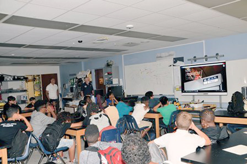
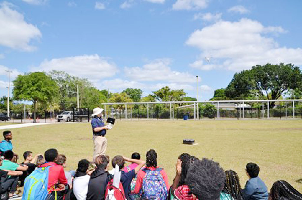
At one school the presentations were made to about 50 students (30 6th graders, and 20 7th graders). At the second school, three or four classes of mixed grades and ages met in the school’s media center as one big group of about 60 students. James explained about Surveying & Mapping using videos, slides and personal experiences, while Patrick physically demonstrated his drone skills in the school yards. This was part of the ongoing community involvement & education that SSMC is involved with throughout the year with students ranging from Elementary School to College.

Beyond the math, science and technology involved; James explained that what draws him to the surveying profession is the time spent in the field. Most geographers, regardless of specialty, are drawn to the outdoors and all that nature has to offer. Much of surveying & mapping is following in the footsteps of those who came before us. Consequently; many practitioners are also historians and conservationists.

I have to admit, though, the technology is pretty cool and that is what drew me to the profession. I studied computer science in college but like many mappers, followed my family into the profession. So I am now applying my computer skills to surveying and mapping. The UAS portion of SSMC’s presentation primarily explained the technology behind the aerodynamic capabilities of the UAS; GPS, IMUs, accelerometers and counter rotating propellers. The students asked questions like “how high can it go?” And “can you make it flip?” Far fewer students were interested in the photogrammetry and math required to process the data.

Photo of Patrick Phillips and his colleague James Mazurak instruct a class
Patrick Phillips and his colleague James Mazurak instruct a class.


Photo of Patrick Phillips demonstrating his drone skills in the school yard.
Patrick Phillips demonstrates his drone skills in the school yard.


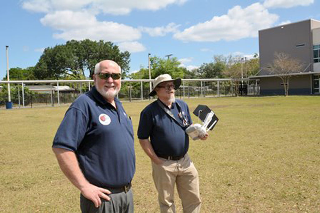
Patrick Phillips (right) holds a drone controller as he demonstrates a flight in the school yard, while his colleague James Mazurak (left) watches.
Patrick Phillips (right) holds a drone controller as he demonstrates a flight in the school yard, while his colleague James Mazurak watches.
    Share

Arleigh H. Laycock

Arleigh Howard Laycock, Professor Emeritus of Geography at the University of Alberta, died June 7, 2018. He was 94.

Laycock was born on May 10, 1924, in Strathmore, Alberta, the son of the late George Henry (“Harry”) and Helia (Riekki) Laycock. He was married for 60 years to Audrey Jean Tyrholm (d. 2010) and had three children: Deborah, David, and James.

From 1943 to 1945, Laycock served as a pilot in the R.C.A.F. He graduated from the University of Toronto with a BA in 1949 and received his Ph.D. from the University of Minnesota in 1957.

Arleigh held the position of Hydrologist with the Eastern Rockies Forest Conservation Board from 1952-1955, whereupon he joined the faculty of the Department of Geography at the University of Alberta, where he served as Professor until his retirement in 1989.

    Share

Robert Stoddard

The geography community at the University of Nebraska Lincoln lost a treasured colleague when Robert H. Stoddard died on May 21, 2018 at age 89.

Stoddard was born in Auburn, Nebraska, on August 29, 1928, the son of Hugh Pettit Stoddard and Nainie Lenora Robertson Stoddard. He married Sally E. Salisbury in 1955 and had three children: Martha, Andrew, and Hugh.

He started his studies at Nebraska Wesleyan where he earned a bachelors in 1950. Stoddard then earned his master’s in 1960 at the University of Nebraska. He received his doctorate at the University of Iowa in 1966 and joined the faculty at the University of Nebraska the following year. He remained there for 40 years, until his retirement in 2006. Altogether, Stoddard has taught for more than 40 years at Nebraska Wesleyan University and the University of Nebraska-Lincoln.

Stoddard was a specialist in the Geography of Asia, publishing especially on the geographic patterns of pilgrimages and sacred sites. He put his geography into practice by travelling widely with his family throughout Asia (and beyond), including extended stays in India and China. Bob had a strong sense of social justice and a keen appreciation of the many legitimate ways to live in this diverse world. Stoddard also taught high school in India (1952-57), and was Visiting Professor at Tribhuvan University in Kathmandu, Nepal (1975-76), and the University of Columbo in Sri Lanka (1986).

Dr. Rana P.B. Singh notes that “Bob was a pioneer in the geographic study of pilgrimages. He commenced his focus on the geography of religion with a Master’s thesis on the locations of churches in a Nebraska county (1960) and a Doctoral dissertation on Hindu holy sites in India (1966). He was co-editor of Sacred Places, Sacred Spaces (1997) and the GORABS chapter in Geography at the Dawn of the 21st Century (2003). His visits to many holy places in India have included the Himalayan sites of Kedanath and Gangotri.”

In addition to much productive research, many scholarly publications (notably Field Techniques and Research Methods in Geography, 1982), and unstinting university service, he also served his local community as a member of the Lincoln-Lancaster Planning Commission (1974-78). He was also a dedicated teacher and mentor, and these qualities were recognized when the National Council for Geographic Education gave him its Distinguished Teaching Award in 1992.

A collection of essays was published in 2016 in honor of Stoddard’s years of exemplary service. A copy of “Space, Region & Society: Geographical Essays in Honor of Robert H. Stoddard” is available online at https://digitalcommons.unl.edu/zeabook/48.

    Share

Joe Scarpaci

Education: Ph.D. in Geography (University of Florida), M.Sc. in Geography (Penn State University), B.A. in Geography (Rutgers University). Post-doctoral Bridge Certificate in Marketing, AACSB (Association to Advance Collegiate Schools of Business)

Describe your job. What are some of the most important tasks or duties for which you are responsible?
I offer investment information for U.S. companies interested in staking a claim in Cuba’s future economy. This entails appraising them of, and simplifying, the current implications for businesses registered in the U.S. that must abide by the Trading with the Enemy Act.

I also design and lead interpretive educational/cultural tours in compliance with the current trade embargo. Since the early 1990’s, I have held licenses through my organization or from the U.S. Treasury’s Office of Foreign Assets Control (OFAC), and have since introduced over 900 American students and civic organization members to the island through these itineraries.

What attracted you to this industry?
My early research in heritage tourism and the Centro Histórico of Latin American cities led me to nine UNESCO heritage sites, including Havana and the more recent addition of Cuenca. My field work addressed city, provincial, and national governments aiming to attract new clientele to their aging historic districts – an alternative traveler than those coming to Latin America and the Caribbean for traditional tropical amenities. Place promotion and branding, I realized, become front and center in understanding how these places aimed to position themselves in the international tourism market. This inspired me to accept an offer from Virginia Tech to a post-doctoral bridge program in marketing, which required 320 hours of intensive summer study. After completing the program and receiving my certificate, I began teaching full-time and online in international business, hospitality, and marketing programs. Additionally, I’m able to consult with businesses in Hollywood and on Wall Street about working in Cuba under U.S. Treasury guidelines.

How has your education/background in geography prepared you for this position?
Geography’s interdisciplinary approach provided an excellent foundation for international marketing, which itself draws on several concepts relating to economic, cultural, and methodical foundations found in geography; however, it’s worth noting that business administration faculty often view interdisciplinary affiliations as “weak”. My “jack-of-all trades” geography training, however, was encouraged. When it comes to publications, books are not as valued as in geography, and the peer-review process is much more rigorous. All in all, my geographical fieldwork methods, foreign language training, ability to synthesize material, etc. have been assets to my work in international marketing.

What geographic skills and information do you use most often in your work? What general skills and information do you use most often in your work?
As I mentioned, the ability to synthesize both qualitative and quantitative information, as well as the ability to effectively display my work in visual and written formats and my Spanish language skills are the tools I most rely upon. Working in Cuba, I was amazed by how many “experts” on Latin America or Cuba had so little knowledge about flora, fauna, political and social history and theory, and climate patterns. I’d sat in on so many lectures where these basic factors — which would be immediately picked up by geography students — were totally absent.

Are there any skills or information you need for your work that you did not obtain through your academic training? If so, how/where did you obtain them?
I mentioned previously my post-doctoral certificate in marketing; otherwise, I’m not sure if field work counts as training, but my Spanish language skills have definitely been most helpful. The notion of “going native” is a false approach; however, I’ve found over the course of doing ethnographic work throughout the region that locals appreciate a foreigner’s ability to speak Spanish. I stress the importance of language to my students; with Spanish in particular, the use of present and imperfect subjunctives tend to be most difficult for English speakers, and I encourage my students to master that.

Having run 32 study abroad programs in Cuba, the Dominican Republic, and Chile and working with international organizations has forced me to summarize my research clearly and effectively. My center has worked with several alumni organization, museums, civic organizations, and high schools and university programs as a result. Taking account of these varying audiences, I try to “hit the right altitude” in giving lectures, assuming very little and presenting interesting and “big picture” topics on globalization, urbanization, consumer behavior, etc. rather than convey trivial information about the region.

Do you participate in hiring, screening, or training of new employees? If so, what qualities and/or skills do you look for?
In the past, I have hired part-time U.S. and Latin American-based scholars. I look for good people skills, strong bilingualism, and effective team players. Travelers in Latin America don’t want a boring and introverted docent accompanying them. Using locals, I also keep an eye out for good English skills, and the ability to keep politics in check.

What advice would you give to someone interested in a job like yours?
I appreciate the luxury of being able to be flexible with my time and with my choice of projects; however, this requires a sense of seasonality and advance planning. Another challenge tends to be good budget development skills and learning how to monetize your skills. Understanding how to conduct a marketing plan, even with geographers who don’t speak your language, is essential.

I stress the balance of having your work validated in North America while earning the respect of locals; with that, I cannot over-stress the importance of language skills. Language skills should not be treated as secondary skills, especially with the decline of Spanish and Portuguese with Fortran and COBOL (in the 1970s) and C++ (recently) being treated as “substitutes” to modern languages in contemporary higher education curricula. You should never assume that any key informants will “speak English anyhow”—personally, this is a terribly misguided assumption.

What is the occupational outlook for career opportunities in your field, esp. for geographers?
Any geographer can find their own niche, but this requires understanding the big picture. In my case, it means understanding supply chains, which in economic geography we might call the production chain or the value-added chain or the commodity chain. At each point, there is an opportunity to connect a market with a client, whether it is a B2B setting (business-to-business) or B2C (business to consumer/client) one. One of my mentors at Penn State, Pierce Lewis, who was a talented and broad-thinking scholar, wrote a Presidential Address in the 1970s following his tenure as AAG President.  In that talk, he urges students to pursue their interests without putting on ‘blinders,’ and then try some more, but to also avoid those with narrow focus who might attempt to put blinders on your vision. He encouraged geographers to work on projects not confined to one place, and that pay attention to context.

While deciding between graduate programs in the mid-1970’s, I was given advice to develop systematic skills at the master’s level, and to then focus on regional specialization at the doctoral level. I opted for a M.Sc. program at Penn State; though they had little in the way of Latin American studies, I did indeed pick this up later at the doctoral level at the University of Florida.

I remember being at Penn State while Peter Gould, the professor of my seminar on the history/philosophy of geography, opened a recent issue of the AAG’s Annals and read the caption of a photo that read something like “Campesino in field in white pants”. He didn’t have to say anything else; it was clear that this was overly descriptive. Hence, the debate on idiographic versus nomothetic approaches to geography, and the quantitate vs. qualitative debates. All geographers will have to choose those paths as their careers evolve.

Two other faculty members at Penn State — Ron Abler and Wilbur Zelinsky — told their graduate students that a good dissertation could be defended in at least two or three other departments; at the time, I found this to be hyperbole on their part, but now I see they were right. My undergraduate advisor at Rutgers (Bria Holcombe) encouraged travel and journaling, even as an undergrad. I echo the advice of these sage geographers.

    Share

Matt Connolly

Education: Ph.D. in Geography & Geographic Information Science (Texas State University), M.A.Geo in Geographic Information Science (Texas State University), B.S. in Business Administration & Management Information Systems (University of Colorado Denver)

What attracted you to a career in education?
When I was a master’s student, I spent a summer working at Texas State’s Meadows Center for Water and the Environment as an interpreter, leading tours and environmental education activities on Spring Lake.  This experience allowed me to teach people about the connection between human activities and physical environments, and to appreciate the power of being an educator.

My first position in formal education was teaching undergraduate GIS labs, and through this experience I realized how much I loved explaining concepts to others. There was nothing quite like that moment of understanding when you witnessed the mental lightbulb flicker to life, and this is the main reason why I decided to become a professor.

How has your education/background in geography prepared you for this position?
I attribute my ability to understand the “big picture” of human-environment interactions through integrating knowledge from multiple disciplines to my geography education.  I stress the importance of the geographer’s breadth of knowledge that allows us to provide unique insights. For instance, my work on municipal water consumption patterns taught me that human, historical, and physical perspectives are necessary in making effective resource management decisions.

My geography education also developed my sense of curiosity about the complex world around us. The ability to think spatially has made me want to explore the patterns that exist around the globe, and aim to get my students to adopt this way of thinking to stimulate their own curiosities and solve problems creatively.

What geographic skills and information do you use most often in your work? What general skills and information do you use most often in your work?
The most important skill I use is spatial thinking to integrate data and more fully understand a given phenomenon. Spatial analysis begins with the framing of research questions pertaining to the spatial configuration of a phenomenon, and then analyzing it with qualitative visual analysis, as well as computational techniques for quantitative analysis. Reading the physical landscape is another important skill, especially in applications involving remote sensing data and fieldwork. Being able to analyze problems from multiple scales is critical in integrating data to solve a given problem, and examining the human, physical, and biological data of a particular issue—for example, water quality— provides a more complete understanding of changes over space and time.

Are there any skills or information you need for your work that you did not obtain through your academic training? If so, how/where did you obtain them?
My academic training has done much to strengthen my teaching, research, and publication experience. Upon completing my graduate degree, I have focused mainly on developing my writing and physical geography fieldwork skills. So far, I’ve improved my writing skills through reviewing journal manuscripts, and volunteering to help train graduate students at colleagues’ research labs has improved my physical fieldwork skills, and has created new research opportunities I would not have had otherwise.

Do you participate in hiring, screening, or training of new employees? If so, what qualities and/or skills do you look for?
As a junior faculty member, I sometimes assist in hiring new staff for the department. When hiring a faculty member, we are most concerned with how well the applicant fits into the existing department and the university as a whole. We look for teaching experience, an engaging attitude with students, and research and publication records, among other things. The importance of each factor depends on the institution type and existing faculty composition; personally, I look for student engagement ability, collaborative skills, knowledge of the university and general disposition. All in all, I look for a candidate that will be easy to work with both now and in the future.

What do you find most interesting/challenging/inspiring about your work? 

The most interesting part of my work is the diversity of responsibilities and working environments; it’s difficult to experience the same day twice!  My typical day on the job is rarely boring, and I’ve greatly improved my time management and correspondence skills, but I still consider it a work in progress. Perhaps the most inspiring part of my job is seeing my capstone students’ professional growth over the semester as they design and execute independent research projects for real-world clients. This course is most of my students’ first directed research experience, and it’s fulfilling to see initial frustration transform into meaningful achievement.

What advice would you give someone interested in a job like yours?
Interest in a job like mine requires strategies in both graduate school and in the job search. During graduate school, ask yourself why you want to be a professor and what interests you most about the job, and discuss these questions with current faculty that you trust. The importance of sharing your thoughts is not for validation, but to gain better insight into your own motivations.

Secondly, learn about the realities of being a professor. Converse with multiple faculty members, and if your department allows it, attend faculty meetings to gain insight into the inner workings of a career in academia, as well as the working dynamics of your faculty.

Thirdly, be honest with yourself about your career goals, and the type of institution you’d feel most comfortable in. Predominantly undergraduate and research institutions each have their own cultures, and the sooner you find your “fit”, the sooner you can adapt your graduate school experience to meet your goals.

Finally, make sure to gain experience with the publication process during graduate school. Demonstrating your ability to publish your work is critical; in addition to its attractiveness to employers, familiarity with the publishing process is an important survival skill, and your institution will want to see that you can publish your research while managing other responsibilities.

As far as job search advice goes, first and foremost: know when and where to look for jobs! Professional association job boards (e.g. the AAG Jobs in Geography Center), higher education websites (e.g. HigherEd Jobs, The Chronicle of Higher Education, etc.), and professional networking sites such as LinkedIn and ResearchGate are all great places to start. Don’t forget that your advisors and faculty can be excellent networking resources as well.

Also keep in mind the academic job season. The primary job season usually begins in August and lasts until October/November, during which postings are heaviest. Positions posted in January or later tend to be temporary or visiting appointments. Pay attention to the details of a particular job ad as closely as possible, and tailor your cover letter with information on the particular institution you are applying to. Finally, don’t shy away from visiting, fixed-term, or post-doc positions. They can make for great short-term alternatives that keep you in the industry, and provide valuable experience for tenure-track jobs.

What is the occupational outlook for career opportunities in your field/organization, esp. for geographers?
The wide applicability of geographers’ core skills in social and natural sciences makes for a strong occupational outlook in higher education. Though many academic geographers work in Geography departments, there are a number of additional opportunities in interdisciplinary settings such as combined departments, research clusters, and the like. Unfortunately, shrinking university and research budgets can exclude many within the pool of qualified applicants. However, there are numerous informal education opportunities for geographers. For instance, many environmental/resource management agencies hire academics to develop materials and relay important information to the public. Though the path to a tenure track position will remain difficult in the future, it’s critical to gain experience and hone your skills within geographic education in the meantime.

    Share

Erin Silva – Project Manager, Maryland

Photo of Patrick PhillipsGeoMentor Volunteer: Patrick Phillips

Location: Orlando, Florida

Grade level of participating students: 6th & 7th

Activity Theme/Focus: Surveying & Mapping

Number of Participants: 110

In conjunction with National Surveyors Week, Southeastern Surveying & Mapping Corp., Inc. (SSMC) participated in presenting Surveying & Mapping as a career to two Orlando area middle schools. James Mazurak and Patrick Phillips from the Orlando office of SSMC along with Lenora Spence, Outreach Coordinator from Florida Department of Agriculture visited the two schools.

At one school the presentations were made to about 50 students (30 6th graders, and 20 7th graders). At the second school, three or four classes of mixed grades and ages met in the school’s media center as one big group of about 60 students. James explained about Surveying & Mapping using videos, slides and personal experiences, while Patrick physically demonstrated his drone skills in the school yards. This was part of the ongoing community involvement & education that SSMC is involved with throughout the year with students ranging from Elementary School to College.

Beyond the math, science and technology involved; James explained that what draws him to the surveying profession is the time spent in the field. Most geographers, regardless of specialty, are drawn to the outdoors and all that nature has to offer. Much of surveying & mapping is following in the footsteps of those who came before us. Consequently; many practitioners are also historians and conservationists.

I have to admit, though, the technology is pretty cool and that is what drew me to the profession. I studied computer science in college but like many mappers, followed my family into the profession. So I am now applying my computer skills to surveying and mapping. The UAS portion of SSMC’s presentation primarily explained the technology behind the aerodynamic capabilities of the UAS; GPS, IMUs, accelerometers and counter rotating propellers. The students asked questions like “how high can it go?” And “can you make it flip?” Far fewer students were interested in the photogrammetry and math required to process the data.

Photo of Patrick Phillips and his colleague James Mazurak instruct a class
Patrick Phillips and his colleague James Mazurak instruct a class.


Photo of Patrick Phillips demonstrating his drone skills in the school yard.
Patrick Phillips demonstrates his drone skills in the school yard.


Patrick Phillips (right) holds a drone controller as he demonstrates a flight in the school yard, while his colleague James Mazurak (left) watches.
Patrick Phillips (right) holds a drone controller as he demonstrates a flight in the school yard, while his colleague James Mazurak watches.
    Share

Otis Templer

Otis W. Templer Jr., 84, passed away on May 8, 2018 at Carillon House in Lubbock, Texas. He was born in Crystal City, Texas, and had lived in Lubbock for the past 49 years. He married Josephine Parks in Dallas. She preceded him in death. He was a member of First United Methodist Church.

He was valedictorian of his high school class and an Eagle Scout. He graduated from Texas A&M University in 1954, and then served as an artillery officer in the United States Army. In 1959, he received a J.D. degree from the University of Texas School of Law and practiced law for several years in Central Texas. He returned to graduate school at Southern Methodist University, earning a master’s degree in 1964, and later a Ph.D. from the University of California, Los Angeles in 1969.

He was the first permanent professor of Geography hired at Texas Tech and was among the founders of the Department of Geography. He came to Texas Tech as an Assistant Professor of Geography in 1968, and was promoted through the ranks to Professor in 1978, and he taught at the university for over 45 years. He served as chairman of the Department of Geography for 15 years until 1994, and as associate chair of the Department of Economics and Geography from 1994 to 2001. He retired from full-time teaching in 2001, and continued teaching part-time until 2015. Almost everyone with a Bachelor’s degree in Geography from Texas Tech has had a class with Dr. Templer. His research primarily revolved around arid lands and water law, largely in Texas.

Survivors include a brother, a son, four daughters, six grandchildren, and two great-grandchildren.

The family suggests memorial contributions be made to the Texas Tech Foundation, Inc. for the “Otis and Josephine Templer Geography Scholarship Endowment,” c/o P.O. Box 41034, Texas Tech.

    Share

Robert W. Kates

Robert W. Kates, geographer, sustainability scientist, beloved husband, father, grandfather and great-grandfather, died in Trenton, ME, April 21, 2018. He was 89 years old.

He was a professor of Geography at Clark University, Director of the Alan Shawn Feinstein World Hunger Program at Brown University, Senior Research Associate at Harvard University, and most recently Presidential Professor of Sustainability Science at the University of Maine.

He was born in Brooklyn, New York on January 31, 1929. Following high school, he studied at NYU. He married Eleanor (Hackman) Kates when he was 19, a marriage that would last 68 years. They moved to Gary, Indiana, where Bob worked in a steel mill for twelve years, and where their three children, Katherine, Jon, and Barbara were born.

Thinking it would be nice to have a job with summers off so he could take his family camping, Bob enrolled in night courses with an eye to becoming a schoolteacher. An instructor who noted his apparent academic aptitude introduced him to University of Chicago geography department chairman Gilbert White, who would become Bob’s life-long friend and academic mentor. Dr. White facilitated Bob’s admission to the University’s post-graduate geography program, despite his lacking an undergraduate degree.

It would be an understatement to say that Bob thrived in this academic environment. Thirteen years following receipt of his PhD in 1962, Kates was inducted into the National Academy of Sciences in recognition of his groundbreaking work in a variety of geography-related fields. He was a recipient in the first annual MacArthur Fellowship in 1981.

Over his multi-faceted career, Bob Kates received multiple awards and honors including the U.S. National Medal of Science in 1991, Honorary Doctorates from Clark University and the University of Maine, the American Geographical Society’s Charles P. Daley medal, the Stanley Brun Award for Creativity from the American Association of Geographers (AAG), and most recently a Lifetime Achievement Award from the Human Dimensions of Global Change section of the AAG.

He served as the president of the AAG, and was proud to be a member of the Intergovernmental Panel on Climate Change (IPCC), which received the Nobel Peace Prize in 2007.

Bob’s academic career was prolific and spanned several interrelated areas. His earliest work was in natural hazards and human perception of environmental risk. His research took him worldwide, from studying reconstruction efforts following the Alaska earthquake in 1964 to helping create what is now the Institute of Resource Assessment in Dar Es Salaam, Tanzania. Later his work broadened to how, in his words, “hazards, nature, technology and society interact to generate both vulnerability and resilience.” This led to work in population studies, hunger reduction, natural resource management, climate change, and foundational contributions to the emerging field of sustainability science.

A geographer by training, Bob’s curiosity and creativity were not constrained by traditional academic disciplines. He loved to ask big questions: “Why does hunger persist amid a world of plenty, and what can be done to end it?”; “How has humankind transformed the earth; indeed, can life be sustained?”; “Can there be a transition to sustainability that over the next two generations would meet human needs, while maintaining the essential life support systems of the planet?”

To help answer such questions, Bob enlisted hundreds of people from the world of academics, policy-makers, and international organizations to work on answers and solutions. His ability to combine ideas that at first glance do not seem to belong together was matched by his ability to engage and recruit wide circles of people from diverse fields to work together. His work style was collaborative: He helped author several books and hundreds of papers, many of which were in conjunction with others.

Confronted with the daunting scope of the problems he studied, Bob’s mode was to fuse academic rigor with a commitment to find achievable goals that could, in his words, “in some small way help change the world.” The question he often shared with his family, underlying all the rest, was “How does one do good in the world?” His lifelong concern with social justice and human rights made him unwilling to divorce practice from theory, to dismiss incremental improvements in people’s lives, or to lose hope.

For example, during his time directing the Alan Shawn Feinstein World Hunger Program, Kates helped develop a program not only to define the scope of global hunger, but also to develop an international multi-component plan to address it. The typical “Kates question” that shaped the program was not how to end world hunger. Instead, it was “What could be done to cut world hunger in half, in the following decade?” What concrete measures were possible, what resources were required, what it would cost, who could pay for it, then how to advocate for action? Bob’s prodigious energy, organizing talent, and inveterate optimism made such undertakings possible.

Bob was predeceased by his wife Eleanor in 2016. He leaves his children: Katherine Kates and her husband Dennis Chinoy, Jonathan Kates, Barbara Kates and her husband Sol Goldman. He leaves six grandchildren: Sam Kates-Goldman, Miriam Kates-Goldman, Shanyu Wang Kates, Sara Kates-Chinoy and her husband, Eric Nelson, Jesse Kates-Chinoy and his wife Mariemm Pleitez, Hannah Shepard and her husband Wade Shepard. He also leaves four great grandchildren: Petra Shepard, Rivka Shepard, Jack Nelson and Ezra Nelson.

Bob loved his family dearly as his life’s bedrock, and welcomed each new member, by birth or by marriage, into the family circle. He was gratified to live long enough to see his grandchildren launched on their various life adventures.

His health declined over the last several years. When his energy and capacity waned, he reluctantly relinquished his engagement with long-time friends and colleagues, and took comfort in the love and care of his family. He continued to relish a tasty grilled steak, a good mystery novel, Patriots football games, and the view from his deck overlooking Trenton Narrows. He died suddenly and painlessly the day before Earth Day.

To foster continuing work regarding his quest, “What is, and ought to be, the human use of the earth?”, gifts in Bob’s memory may be made online to the Robert W. Kates Fund for Creative Graduate Studies at umainefoundation.org/memorial to benefit the Mitchell Center for Sustainability Solutions at the University of Maine. Or donations can be mailed to the University of Maine Foundation, Two Alumni Place, Orono, ME 04469 with a note that it is for the Mitchell Center Robert Kates Fund.

A memorial service will be held sometime this summer.


Source: https://obituaries.bangordailynews.com/obituary/robert-kates-1929-2018-1057279836

    Share