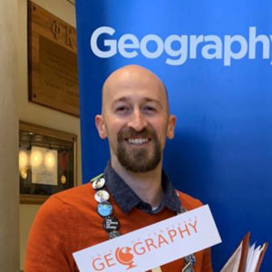
Sean O’Brien

Education: Master’s in Geographic Information Science (University of Minnesota), B.S. in Geography (University of Minnesota)

Describe your job. What are some of the most important tasks or duties for which you are responsible?
I work in the Enterprise Research and Analytics group. The foundation of my job involves creating and maintaining our geographic datasets, as well as creating self-service mapping applications where our employees can go to explore and export maps, data, and reports. The main responsibilities of my job involve supporting our business lines with their geographic analysis needs. Going along with that, I do a lot of in-depth analysis for specific projects. I do things such as analyzing branch usage, and where customers who use branches are coming from. I also support the team that decides where to put new assets such as branches and ATMs.

What attracted you to this career path?
I discovered GIS when I was in college. I had an interest in geography, but I was also interested in statistics. I talked to an advisor who told me about GIS, so I decided to take a class to check it out. On the first day of class we all got a sheet of paper and rulers, and were instructed to draw points on a blank sheet of paper, and then draw these lines and points in a specific manor around those initial seed points. After doing this for about fifteen minutes I was instructed to erase some of the lines, and the instructor informed us that we had created a Voronoi Diagram (also known as Thiessen Polygons). This diagram creates polygons around each seed point, and any point within that polygon is closest to that seed point compared to the other seed points. The real-life example the instructor used was plotting points for a chain restaurant on a map. He then drew the polygons and explained that this is how I could find the closest restaurant from wherever I was in the city. After all that we were told that there was GIS software that could do what we just did in a matter of seconds, and that was just the tip of the iceberg for what that software was capable of. At that point I knew I wanted to learn much more about GIS. Once I started to learn more, I knew this is what I wanted to do for a career.

How has your education/background in geography prepared you for this position?
Taking geography classes as an undergraduate student was very helpful to prepare me for my future jobs. Understanding geography is a critical foundation to a GIS career path. Things like surveying, GPS, projections, and coordinate systems were required knowledge for all of my positions. Cultural geography also plays a role in my current position. Ideas such as demographics, cultural movements, and Tobler’s First Law of Geography (near things are more related than distant things) is all useful knowledge in my current role. Why do people live in certain places? What tendencies do people in specific regions have? How does the geography of a place impact people’s behaviors? Understanding people as it relates to geography is critical in a GIS/Geography business.

What geographic skills and information do you use most often in your work? What general skills and information do you use most often?
For geographic skills and information: Understanding projections and coordinate systems is always needed in a GIS line of work. It is the foundation to most GIS operations. The other most useful geographic skill is understanding the geographic software. I use it all day every day, so being familiar with the software and the geographic functions inside of it is critical. Census and related demographic datasets are used frequently in my line of work. It is very useful to be able to take tabular data, attach it to a geography, and then parse that data out by other geographies. Most geographic data is useful in business. Data such as geographic boundaries, road networks, addresses, and demographics are all used on a regular basis.

For general skills: In my work, understanding basic statistics and math is needed on a regular basis. I deal with a lot of tabular information, so having a grasp of regression, correlation, and statistical and geographic patterns is key to being able to analyze data. Related to tabular data, knowledge of Excel is required. Many things I do require me to deliver data in an Excel format. The other skill I use frequently is coding with Python. I automate geographic tasks using the code which is a critical part of being a GIS Analyst as it allows me to free up my time from doing monotonous and repetitive tasks. The final general skill I use most often is understanding and working with databases. U.S. Bank has tons of data, so understanding how databases are structured, and how to query that data is key to getting my job done.

Are there any skills or information you need for your work that you did not obtain through your academic training? If so, how/where did you obtain them?
Most of the skills I need were at least touched on during academic training. However, there are two skills that I’ve learned that were never touched on in school. The first one is how to present analysis to executives. This is something that isn’t brought up in school, but it’s very important to be able to craft a succinct story that an executive can understand. I cannot just dump data, create a chart, or regurgitate a bunch of stats and expect executives to understand what I’m trying to say. There are a couple good books that go over the main concepts of how to present data. I’ve also learned a lot from my peers and how they’ve presented things in the past.

The other skill that I did not learn in school was networking. Networking is very important both when looking for a job, and while working in a large company. Sometimes our GIS team needs to sell ourselves to others in the company. We find the right people, explain how we can help them out, and then deliver great work. If this process works, we can become a trusted partner for many business lines, and we can become respected by more business lines and executives.

Do you participate in hiring, screening, or training of new employees? If so, what qualities and/or skills do you look for?
In my current and previous jobs I have read through resumes and interviewed prospects. When reading through resumes, there are a few key things I like. One is concise information. For me and others in my position, reading through resumes is a pain because it’s tedious and it takes away from my main work. If I have to read through dozens of resumes and I come across a four-page resume, I’m likely to skim through in hopes that I find relevant information. In my opinion a good resume would be one page. I would start by listing your current job, and then list projects you’ve done that are directly related to the top qualifications and/or skills listed in the job posting. Try to use the exact verbiage used in the posting. This is what I’m looking for.

When interviewing, be sure to dress nicely. I personally don’t look for a suit and tie, but I would recommend a dress shirt and dress pants at a minimum. When I am interviewing for a position, I try to follow the STAR method of answering questions – “Situation,” “Task,” “Action,” and “Result.” When I’m interviewing, I’m not necessarily looking for that format of an answer, but that method makes sure you hit the main points when answering a question, and it allows you to not go off on an irrelevant tangent.

And of course, try to be nice. The people who are interviewing you will most likely be your manager or peer. They’re looking for people who will be easy to work with.

What advice would you give to someone interested in a job like yours?
First I would recommend getting at least an associate’s degree in geography or GIS. Learning the base theory is integral to understanding how to do things in the main GIS software. Second, I would become as familiar as possible with GIS software. Almost every GIS job looks for experience in ArcGIS. I think the future of GIS involves more coding than one might think. Learning something like Python, which is one of the easiest languages to learn, is a really good start. Once you get a good foundation you can try to branch out from there if needed. Finally, I think having at least a little exposure to things like statistics, IT infrastructure, and database management is beneficial. Once you get your foot in the door you can learn more about those as the job requires.

What is the occupational outlook for career opportunities in your field/organization, esp. for geographers?
Overall, I think the outlook is good. GIS spans across so many different professional fields, and more industries and entities are discovering the benefits of it. Even small cities and counties are investing in resources to improve their geographic analysis capabilities. Furthermore, more data has become available for consumption, allowing more analysis to be done. On that point, the demand for geographic data has grown to the point where there are entire companies dedicated to gathering and maintaining it.

I’ve had three GIS jobs – One in city government, one in consulting, and now one in private business. Currently, all three of those teams I was on have more people working with GIS today versus the day I started. There were also people within the consulting firm whose jobs were not related to GIS, but they were learning GIS on the job because it helped them with their work.

At U.S. Bank, I think we’re showing other business lines and executives what we’re capable of, and so the demand for our services has grown. I believe in the future that even smaller businesses will think of GIS as less of a luxury, and more of a necessity.

    Share

Michael Camponovo – GIS Outreach Coordinator, Tennessee

Photo of Michael Camponovo, courtesy EsriPosition: GIS Outreach Coordinator, Geography Department, University of Tennessee Knoxville

What was your favorite class in K-12? Survey of Literature with Gloria Oster at Sullivan South High School. I always liked to read but she introduced me to so many new authors and literary styles.

How did you first learn about and/or use GIS? I was an undergraduate student at TN Technological University in Cookeville, TN studying Soil Science and my advisor said I should take “one of those computer mapping classes” as an elective. I haven’t stopped learning about GIS since then.

Name one thing you love about GIS and/or geography: I love the interdisciplinary nature of GIS, I have the opportunity to work with so many talented professionals and researchers to help them answer questions and solve problems that I otherwise would never know existed.

Why did you want to volunteer as a GeoMentor? I want young people in Tennessee to know that geography and GIS are a viable career path that lead to a lot challenging and engaging opportunities.

If someone asked you why they should learn about GIS and/or geography, how would you respond in one sentence? Everything happens somewhere.

Websites:

Twitter@mcamponovo

    Share

A Day in the Life of a Geographer


    Share

David Schwarz

David Schwarz (1936-2019) was a professor of geography at San Jose State University. He passed away in Gilroy, CA, aged 82, after a long struggle with Parkinson’s disease.

He was born in Mattoon, Illinois, the 2nd of 7 children raised in a two-bedroom home with a coal stove for heat, and no indoor plumbing. After graduating from Mattoon H.S. he had a series of part-time jobs. The one that became the most significant was as a disk-jockey at a local radio station playing country and western music. To his friends, he seemed to know every country and western song ever recorded (both lyrics and melody). A random word or phrase in conversation would sometimes launch him into a song.
He continued with part-time jobs while attending Eastern Illinois University in Charleston, a few miles east of Mattoon. He graduated in 1963 with a double major, art and geography. One part-time job using his art skills, was to paint colorful signs in grocery store windows advertising weekly sales. It was during this era that he served six years in the National Guard.
David then attended Southern Illinois University (1963-1965), but left to pursue a Ph.D. degree at the University of Kansas under David Simonett, a world-renowned scholar in the field of remote sensing. Dr. Schwarz completed his Ph.D. in 1975, with a dissertation titled “Variability of the Accuracy of Delineating Agricultural Field Boundaries from Satellite Images of the United States.” He accepted a position in geography at San Jose State University in 1971, and rose through the ranks to become a full professor. David’s publications were in the general area of remote sensing, and he taught many courses on this subject. He spent his entire career at SJSU, and was an excellent teacher, attracting many students to his regional classes. He had small classes of dedicated students when teaching technical courses (as remote sensing, digital image processing, geographic information systems, cartography, and the like).
SJSU was in financial difficulty in the early 1980s, and social science layoffs were threatened. David helped alleviate this situation by accepting a position as a Visiting Professor at the Air Force Academy for two years (1980-82). He later taught courses on statistics in the College of Business in order to strengthen their doctoral program (in areas for which he was not trained, business or statistics, but he did an excellent job). Throughout his career David served on university committees and gained much knowledge of the university and how it operated. He was a very likeable and competent person, known for his integrity, and thoughtful and reserved demeanor. One of his colleagues called him “the Gary Cooper of the university.” Through committee work he developed many friendships with fellow professors in different disciplines. This deep background was a great help when he accepted administrative positions at SJSU.
Dave began his administrative work as Chair of Geography and Environmental Studies (1991-1995). He had the difficult and challenging task attempting to unite the two disciplines. David later began a five-year term (1996-2001) as Associate Dean in the College of Social Studies. These were the happiest years in his career, as he received wonderful support from the college staff, and from friends and staff in various departmental offices. David retired from SJSU in 2001, but continued to teach a course most semesters until the sudden departure of a dean. He once again helped SJSU, as he served as a dean for another year, and retired for the last time in 2005.
He is survived by his wife Deborah Walker Schwarz, two children, Sarah Nilsson and Noah Schwarz, and two grandchildren. He was predeceased by his parents, Raymond Noah and Gladys Elizabeth Schwarz, and two brothers James and Joseph Schwarz.
By Malcolm Comeaux and Deborah Schwarz
    Share

William L. Graf

William L. Graf one of the nation’s leading geomorphologists and riverine policy scholars passed away on December 27, 2019 at the age of 72. At the time of his death, he was working on a book length manuscript on American Rivers using multiple lenses—arts, history, science, engineering, public policy, and philosophy.

Graf was a Foundation University Professor Emeritus at the University of South Carolina. Before coming to the University of South Carolina in 2001, he was the Regents’ Professor at Arizona State University. Graf received his Ph.D. from the University of Wisconsin in 1974 with his first academic appointment at the University of Iowa after a brief stint as an intelligence officer in the U.S. Air Force.

Dr. Graf published 14 books, his most notable are Fluvial Processes in Dryland RiversWilderness Preservation and Sagebrush RebellionsPlutonium and the Rio Grande (which won the Kirk Bryan Award from the Geological Society of America), and Dam Removal: Science and Decision Making. Among his more than 150 publications are his seminal articles on the hydrologic and geomorphic effects of hydroelectric dams on American rivers (“Dam nation: A geographic census of American dams and their large-scale hydrologic impacts” in Water Resources Research (1999) and “Downstream hydrologic and geomorphic effects of large dams on American rivers” appearing in Geomorphology (2006)).

Dr. Graf received numerous awards throughout his distinguished career from the AAG (G.K. Gilbert Award, Research Honors, Meredith F. Burrill Award, Mel Marcus Career Achievement Award, Water Resources Distinguished Career Award), the Geological Society of America (Kirk Bryan Award), and the British Geomorphological Research Group (David Linton Research Award). He also received the Founder’s Metal of the Royal Geographical Society of Great Britain, the John Wesley Powell Award from the U.S. Geological Survey, and the U.S. Army Outstanding Civilian Service Medal for his contributions to the U.S. Army Corps of Engineers. This was in addition to his receipt of the National Associate award from the National Academy of Sciences and his election as a fellow of the American Association for the Advancement of Science (AAAS).

Equally impressive is Dr. Graf’s service record to the AAG and the Geological Society of America’s, Quaternary Geology and Geomorphology Division. For the former he served as Vice-President and President, a Council member, and on numerous committees. For the GSA he was also Vice-President and President as well as serving on additional committees. During his career, Graf served as an associate editor for the AnnalsPGGSA Bulletin, and Environmental and Engineering Geosciences.

Throughout his distinguished career, Dr. Graf never lost sight of his intellectual home in Geography. He supervised 38 PhD and master’s students and served on many more graduate committees. While trained in physical geography with a minor in water resources management, Graf’s perspective and interest in the intersection of science and policy for public land and water made him one of the country’s most sought after science advisors and expert witness in resolving conflicts between environmental preservation and economic development, and the interaction between science and natural resources decision-making.  Most of these policy consultations engaged his expertise on human impacts on river morphology, processes of contaminant transport and storage in river sediments, downstream impacts of large dams, and riparian habitat changes in rivers. He advised local, state, and federal agencies (including the Bureau of Reclamation, U.S. Army Corps of Engineers, Department of Energy, and the National Park Service), as well as non-profits. He served as a consultant and expert witness in 30 legal cases on wetland and river processes and the effects of hydroelectric dams on downstream rivers. President Clinton appointed him to the Presidential Commission on American Heritage Rivers, and Secretary of Defense Chuck Hagel confirmed him as Chair of the Environmental Advisory Board of the U.S. Army Corps of Engineers.

Dr. Graf felt that professional service to the non-governmental entities such as the Heinz Center and the National Academies of Sciences, Engineering, and Medicine was critical in fostering the intersection between science and public policy. Not only was he a member of many different Boards but also standing committees including chairing the Geographical Sciences Committee, four committees overseeing science for the restoration of Florida Everglades, the committee on sediment issues in the Missouri River. His longstanding advocacy for geographical science to support public policy decision making on rivers and land management have left their mark and opened doors for other geographers to carry his prospective forward.

While his core was geography, the discipline never bounded his identity and scholarship. His willingness to seek knowledge, ideas, and approaches and integrate these into his study of rivers, public lands, and policy has enriched our discipline in a myriad of ways both large and small. Dr. Graf was among the staunchest supporters of geography and never shied away from his identification as a geographer, especially in his public policy and advocacy work. He was the leading light of his generation of geographical scholars and the consummate professional. We will miss his wise counsel, his sense of humor, and most of all his all-encompassing selfless spirit and encouragement to press on.


—Members of the University of South Carolina Geography Department

    Share

Sylvia Chant

The career of feminist development geographer Sylvia Chant was cut short on December 18, 2019 at age 60, when she died of pancreatic cancer. As reported in her obituary in The Guardian,during her career, Chant challenged the received notion that households headed by women in developing countries were automatically more likely to live in poverty than those headed by men. Chant argued that multiple household responsibilities and obligations in relation to men were the greater challenge to women’s lives and success.

Her books include Women-headed Households(1997) and Gender, Generation and Poverty(2007). Writing of her in The Guardian, colleague Cathy McIlwaine described Chant as “keen to work with other researchers[. S]he co-authored and edited 11 of her 18 books, including four that we wrote together, of which the most recent was Cities, Slums and Gender in the Global South (2016). She edited the International Handbook of Gender and Poverty (2010), whose more than 100 chapters came from 125 established and early career authors.

As a professor at the London School of Economics, Chant was known as an inspiring and generous teacher, who influenced many PhD students to work on gender and international development around the world.

Her ideas around women-headed households and wider gender inequalities helped shape the policies of international agencies such as the Commonwealth Secretariat, UN-Habitat, the International Labour Organization, UN Women, and the World Bank. Her work with the Gambia Committee on Traditional Practices Affecting the Health of Women and Children contributed to the country’s final outlawing of female genital mutilation in 2015.

Born in Dundee, Chant grew up in London and earned a geography degree from King’s College, Cambridge in 1981. She attained her PhD at University College London in 1984, studying the role of women in the construction of housing in Querétaro, Mexico. McIlwaine noted, “This was among the first studies that recognised women as key actors in self-build housing in poor urban communities in countries of the global south.”

She is survived by her husband Chris Mogridge, her mother, June, and two sisters, Adrienne and Yvonne.


    Share

Cuchlaine King

Geomorphologist Cuchlaine King died on December 17, 2019 at the age of 97. As a member of the geography department at Nottingham University since 1951, King’s studies addressed many landforms and landscapes, particularly beaches and glaciers.

At a time when scientific expeditions to remote locations were often closed to women, in 1953 she embarked on a university expedition to Iceland to study and survey glaciers. Later in the 1950s,and 1960s, she took part in the Cambridge expeditions on the Austerdalsbreen glacier in Norway and the Baffin Island, in Canada. 

Cuchlaine was born in Cambridge,where she later went on to study geography at Newnham College, graduating in 1943. Cuchlaine’s publications include Beaches and Coasts (1959), Techniques in Geomorphology (1966), and Glacial and Periglacial Geomorphology (1968). She was an early proponent of “quantitative geography”, the use of numerical and statistical techniques to describe and explain landform development. In 1961, Cuchlaine became one of only two women in the founding group of academics that became the British Society for Geomorphology. In 1981 she was awarded the Linton prize from the BSG for her contributions to the subject.

Cuchlaine is survived by a niece, Jane, and three nephews, Nicholas, Timothy and John.

    Share

Lisa Colson

Education: M.A. in Geography (George Washington University), B.A. in Environmental Studies (Eckerd College)

Describe your job. What are some of the most important tasks or duties for which you are responsible?
In our workplace, we use a variety of decision support services and I am responsible for knowing how to use all of them, providing geospatial training, and responding to certain map requests. We use a variety of vector, raster, and satellite imagery data sets, requiring advanced knowledge to ensure proper scientific data handling to efficiently conduct analysis. My work involves mapping crop conditions, weather, crop distribution, and trade policy and effects. Sometimes, I have a project for 2-3 weeks and other times, I have new challenges each day. Each map request requires me to be creative in distilling multiple data sets into clear and concise policy messages. We talk a lot about the subtle messages conveyed in our use of colors, annotations, and other cartographic features.

What attracted you to this career path?
I was attracted to this industry because geography provides a more flexible approach to integrating different disciplines of information into summary messages about health, the environment, international development, and other complex topics. Working in agriculture, especially around the world, addresses many of the interdisciplinary topics that interest me, including food security, sustainable development, and poverty alleviation.

How has your education/background in geography prepared you for this position?
As an analyst, I was required to take initiative to learn how to process satellite imagery into clear, concise stories about current crop conditions. I had to be flexible in identifying areas where the data and tools I had could provide a reliable and accurate sense of the crop conditions, taking into consideration constraints in the spatial resolution, timing, cloud free percentage, and other details that would hinder or support my ability to perform the analysis. Time and computer network constraints often played a significant role in figuring out if an analysis would be realistic to tackle.

My education in geography and specifically remote sensing provided me with the necessary foundation to advance my skills for the specific analytical demands of my current workplace. In addition, my background in policy communication greatly supported me in creating well-received map products that simplified complex data into clear policy messages. I really loved doing that analytical work.

More recently, I have become a graphics editor and training coordinator to help build upon the geospatial skills of my colleagues. With newer staff and the many decision support tools that we use, it is challenging to stay abreast of application developments. Communicating how I did my work, while staying abreast of the applications, is a newer and still rewarding challenge for me. I enjoy sharing my love of geospatial analysis and remote sensing with colleagues, especially as the industry leap frogs forward with technological advancements.

What geographic skills and information do you use most often in your work? What general skills and information do you use most often?
Geographic skills:  I think I most often use location identification, in the sense of advising colleagues to clarify the locational extent of the map image. This is done by adding rivers, roads, cities, and other geographical context to the maps of satellite imagery and other raster data sets. Yet there is more to this. The main geographic questions we tackle are (1) how much grows (in terms of crops) in a given place and (2) what are the conditions of the crops in that place? The important skills myself and colleagues use to answer these questions are spatial joins (aka, making geospatial data sets from tabular data), difference mapping (with raster calculator and post-classification change detection), zonal statistics (to help summarize data to counties or states), and other area calculations.

In the world of remote sensing, I am also required to know the name of many satellite sensors and some basic sensor specifications. For example, sometimes management thinks higher spatial resolution would help make it easier to answer key questions, but these sensors are often missing other critical data. I periodically engage in important discussions about the trade-offs between time and processing speed when considering the geographic extent, timing, and spatial resolution of different imagery sources. Having the technical expertise and yet flexibility to talk with non-technical decision makers is a critical aspect of my work.

General skills: I frequently use writing and presentation skills. I present at conferences about interesting analysis I have done or new product development, such as the Global Agricultural & Disaster Assessment System (GADAS). GADAS is a free, global website that provides a geospatial platform for analysis with hundreds of data layers. When showcasing this or other workflows, I heavily utilize my PowerPoint skills preparing slides. My work also requires me to talk with users of our applications to figure out their challenges and the assumptions that they bring to the application. Sometimes knowing an application well makes a person blind to how others might approach using the same tool. I frequently communicate with people who are not trained in geography, but it is my responsibility to help them be able to perform certain geographical tasks. It can be challenging and requires me to have patience and sometimes think creatively.

Honestly, I far more frequently use general skills to perform my duties, as I review our decision support systems, report bugs on where the applications are having issues, and advise on improvements to these systems. Technically, I am testing geospatial applications and therefore using geospatial skills, but any tester can tell you that they are not being overly creative in performing this task. My work involves far more documentation than I would probably prefer to admit. Yet, concise writing that captures a concern or requirement for a developer to efficiently fix or enhance a decision support tool has its merits. That “telephone game” sometimes works better than other times.  When it works, it is very rewarding.

Are there any skills or information you need for your work that you did not obtain through your academic training? If so, how/where did you obtain them?
Sure, and yet the skills I need I have built upon from my academic training. For example, my previous career in the non-profit world taught me more about using PowerPoint effectively and giving presentations, and yet I learned presentation skills during school as well. In addition, I of course had to write many papers in college and graduate school. These assignments prepared me well, and yet I spent my first 3-5 years in DC learning a completely different writing style. After all, policy memos, briefing papers, and even 5-15 minute presentations for the office are so different from what I did in college.

Here’s another way of thinking about this: some people believe the purpose of going to college is to learn a skill, but instead it is often to learn how to think critically. So how do I identify skills I learned outside of school, when I am constantly thinking through new challenges and exploring solutions to build upon my academic foundation? To me, this is honestly the difference between a job and a career; and I love having a career.

Do you participate in hiring, screening, or training of new employees? If so, what qualities and/or skills do you look for?
First and foremost, I look for the skills needed to perform the job. This is sometimes easier said than done. I work in a place that needs talented people in a variety of arenas. Finding a person with a diverse set of skills can be very challenging and this makes the art of screening for new employees more fluid than some people might expect.

We need people who can be clear and concise in presenting information. The resume or CV is a first indication of this skillset. Sometimes technical people list out all of their skills, but with little organizational structure that helps provide a sense of the person and their history. I always look for people with not only the technical skills, but also an interest area relevant to our work, whether this is meteorology, agronomy, international development, food security, or another relevant field. This helps me know the person could provide scientific quality analysis in an operational environment.

We also look for a person who can be flexible to work with a variety of personality types. Every workplace has a culture and it’s nice to find people who can blend into that culture instead of shaking it up. An interview is as much about the candidate as it is about the team and being able to envision the candidate contributing something new or missing to the team.

What advice would you give to someone interested in a job like yours?
First, don’t be afraid to get to know a variety of tools. Second, geography is a tool that can be applied in many different disciplines. Take the time to develop some expertise in a discipline, where you can geospatially analyze relevant data. Conducting analysis goes beyond knowing how to use the tools, as it is important to also understand the data and proper data handling needs. Third, realize all jobs involve some data cleaning, file management, and time management. No one is too important to do these tasks.

Most importantly, my advice is to take on challenges. Start by finding the little things that are not working well and fixing them. Focusing on tasks within your areas of responsibility that help things function better is a way for you to take initiative and expand your area of expertise. Finding the right time and place to take initiative is incredibly important. It makes all the difference between getting criticized for stepping outside your lane and being rewarded for showing the necessary initiative to solve an important problem. Workplaces are as broken as we allow them to be, so try not to be the source of problems when there is so much interesting work that could be done.

What is the occupational outlook for career opportunities in your field/organization, esp. for geographers?
Sometimes I think geography is currently exploding. Technological infrastructure has finally caught up with the wishes and desires of many analysts. Now with cloud computing, it could be possible to process not just gigabytes, but terabytes of data. Demand for geographers, especially combined with remote sensing data, has increased over the past 10 years, and with more powerful computers the possibilities for working with these data are only limited by our creativity.


    Share

Doug M. Amedeo

Doug M. Amedeo, professor emeritus of geography at the School of Natural Resources, died Dec. 4, 2019, in Lincoln.

Amedeo was a leader in environmental perception and behavioral geography, focusing his career on the human dimensions of environmental and spatial issues. He began as an associate professor at the University of Nebraska-Lincoln in 1973, after serving for five years as an assistant professor at the University of California.

By 1992, he was promoted to full professor, and in 1993, he became the chair of the Department of Geography, which later was merged with the Department of Anthropology, and then the School of Natural Resources, his permanent faculty home. He served in that role for three years.

Amedeo also was a permanent member of editorial boards for the journals of “Architectural and Planning Research” and “Environment and Behavior,” and served on more than 18 university committees over the years.

During the course of his career, he published and presented more than 70 books, chapters, articles or papers and advised nearly 20 graduate students in pursuit of their doctorate degree. Even in his retirement, he continued to work with, advice and inspire students at the University of Nebraska-Lincoln.

Amedeo was born Sept. 21, 1932, in Brooklyn, New York, to Guido and Jean (Gong) Amedeo. He served in the Korean War and, in 1962, earned his bachelor’s degree in economics from Wisconsin State University. He earned his master’s and doctorate degrees in geography from the University of Iowa in 1965 and 1967, respectively.

In 1977, he married Patricia Herriott, who survives him. He also is survived by his daughters, Cynthia Amedeo Nelson of Lincoln and Elizabeth Amedeo Stigleman (Marty) of Midland, Michigan.

A celebration of his life will be in spring 2020; Wyuka Funeral Home is in charge of arrangements. In lieu of flowers, memorials made be made to women’s, children’s or animal charities. Condolence can be left at Wyuka.com.


Published from the School of Natural Resources, University of Nebraska – Lincoln.


    Share

Carl Lewis Johannessen

Carl Lewis Johannessen (1924–2019), a literal and figurative giant of cultural-plant geography and cultural-diffusionist studies, died at age 95, on 13 November 2019. He was Professor Emeritus and one-time head (1978–1981) of Geography at the University of Oregon, where he had been hired in 1959. Carl was a charter member of the Editorial Board of Pre-Columbiana: A Journal of Long-distance Contacts, which I founded and edit, as well as a contributor and the dedicatee for book 6(2–4). The geographer Daniel W. Gade pointed to his contributions as a cultural diffusionist, in book 3(1–3).

Born in Santa Ana, CA, on 28 July 1924, Carl served with the Navy in the Pacific during World War II. He earned a B.A. in Wildlife Conservation and Management at the University of California, Berkeley (1950), an M.A. there in Zoology (1953)—both under A. Starker Leopold—plus a Ph.D. in Geography (1959) with Carl O. Sauer. Johannessen was one of the last living links to the “Old Man” among products of the “Berkeley School.” Another influence was the Missouri Botanical Garden botanist Edgar Anderson.

Johannessen was an inveterate library and field scholar, though one little concerned with convention. He examined human impacts on wild plants as well as domestication as a process and the histories and geographies of individual domesticates. He initially worked in the Americas and in 1999 received the Conference of Latin Americanist Geographers’ Preston E. James Eminent Latin Americanist Career Award (see C.L.A.G. Yearbook 25). However, from 1985 on, turmoil in Central America led him to concentrate instead on South Asia, where horticultural similarities inspired hypotheses of pre-1492 transoceanic interinfluences. He also worked in China and in Polynesia.

Johannessen followed up on my 1978 observation concerning the depiction of a maize ear in a pre-1492 South Indian sculpture, discovering hundreds more and recognizing images of other American domesticates (confirmed by Shakti M. Gupta in 1996). During the 1980s, his presentations on this generated considerable interest. At a 1988 conference, Carl met the Brigham Young University anthropologist John L. Sorenson, which led to a collaborative encyclopedic collection of data demonstrating the previously unimagined magnitude of the pre-Columbian interhemispheric exchange of organisms. World Trade and Biological Exchanges Before 1492 represents a particular milestone in the study of pre-Columbian human mobility. It was self-published, commercial presses having considered the esoteric content to be unsalable.

In 1973, Carl had encountered the Asian-looking black-boned, black-fleshed chicken (“BBC”), in Guatemala, and he and his hiree May Fogg discovered that Native American (but not Mestizo or Euroamerican) keeping of this strain was widespread, as were associated medicinal usages closely reminiscent of practices in China.

In 2016,Johannessen published a more-popular book on early international biological transfers: Pre-Columbian Sailors Changed World History (like the 2013 volume, reviewed in 2019 by Charles F. Gritzner, in The AAG Review of Books 7). The ever-game 94-year-old Johannessen’s last conference presentation was delivered in Sitka, in 2018.

Carl was also concerned with practical applications concerning cultivated plants and engaged in plant-breeding experiments on his farm.


Stephen C. Jett

University of California, Davis

333 Court St., NE

Abingdon, VA 24210-2921

scjett@hotmail.com

    Share