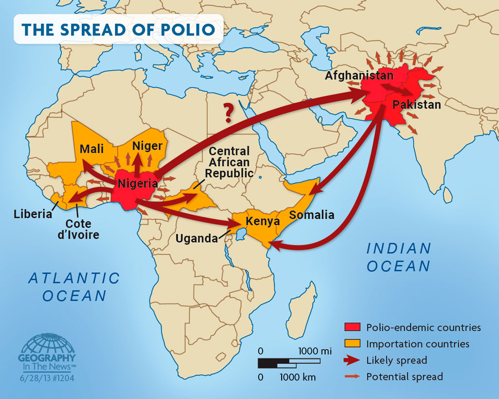
Michael Camponovo

By Annie Liu, AAG Intern

Being the GIS Outreach Coordinator for the University of Tennessee, Knoxville’s Geography and Sustainability Department , as well as having various “other duties as assigned,” Michael Camponovo approached this new position by defining what he thought outreach should mean and who to outreach to. Groups like incoming students, current students, geography professionals, and the public are all prime targets for conducting outreach to ensure the department’s success in recruiting and retaining students. He then needed to decipher what to communicate and how to build relationships with the communities in question and decided to do so, oddly enough, the lens of a business.

Michael’s most recent degree is an M.B.A. from the University of Tennessee (UT), so he “had to think about the department like a business, which is normally something you don’t want to hear in higher ed… but [he] actually found it a really enlightening and fun exercise.” He discovered that thinking about returns on investments for his time, effort, and energy delivered the best results for outreach.

First, Michael thought about the supply and demand of students—where were the students coming from and how many did the Geography and Sustainability Department need. After some trial and error, he found that the best use of his time was working with and recruiting students who are already enrolled at UT.

Michael then had to ask himself, “What am I selling and what’s the quality of the product?” The answer was clear.“ … What we’re selling is an education, and most students one way or the other want some sort of career once they come out of the program.”

By “selling” a geographic education, he needed to focus on post-graduation outcomes for students, so he spent a lot of time working with professional partners. Michael is heavily involved with the Tennessee Geographic Information Council (TNGIC), the Tennessee statewide GIS professional organization, where he serves on the board, organizes conferences, and heads committees. By being involved, he stays knowledgeable about the skills that students need to be taught to be hired while simultaneously building an extensive network, so he is able to recommend students to employers.

On top of being a GIS Outreach Coordinator, Michael also teaches GIS and the geography major capstone course for seniors.

Using Networks to (Re)Discover Geography

“I never thought of myself as a geographer. I had a career before what I do now, where I was a public school teacher, and it turned out that after a couple years of doing that, I decided it wasn’t a good fit for me and I wanted to go back to school and do something different. I had such an unpleasant time being a public school teacher that I was really desperate to find something that brought me happiness and joy.”

Michael was reminded that he liked his GIS classes during undergrad and that it brought him the joy he was looking for, so he reached back out to his professor who happened to be another active member of TNGIC for advice. Since he already had a master’s degree in education for teaching, he only had to obtain a GIS certificate to start working in the field.

Unfortunately, this was right at the start of the 2008 financial crisis, which meant that no one was hiring. Fortunately, he had an opportunity to move to New Mexico with his wife for her pharmacy program, and the University of New Mexico had a paid research assistantship for GIS where Michael realized he was more of a geographer and not just solely a GIS person.

The Power of Mentorship

Michael emphasized the influence of amazing mentors he’s had throughout his time in higher education that he wouldn’t have been introduced to otherwise. He may have two master’s degrees, but what prepared him the most for his current position was his experience as a research assistant at UNM and the mentors he had there.

“I had an amazing mentor, Karl Benedict at UNM, and he was the head of the Earth Data Analysis Center (EDAC). I started out doing work for him like writing metadata and coding and that sort of stuff. They liked what I was doing and they had an opportunity to hire me full time. And so I went to work for them and I had two more amazing mentors, Shirley Baros and Mike Ingalls, and they took me under their wing and coached me up from being a student with potential to being a geospatial advocate for the State [of New Mexico].”

Michael’s new responsibilities required him to communicate to non-GIS people that GIS is helpful with natural hazard mitigation. He says he gave 20 presentations the first year of working at the EDAC, and now he gets paid to talk to people.

What geographic knowledge do you need for your current position?

Being the GIS Outreach Coordinator, Michael seems to know, and needs to know, a little bit of everything about geography. Why? So he can reach the maximum number of people with various interests in geography. He also needs to know what the high-level trends for technical skills are in geography to ensure post-graduation success for students. An example of Michael’s success is the geography department at UTK using ArcGIS Online earlier than most other programs, leading to students learning about StoryMaps and Dashboards earlier as well.

“The thing that has served me the best through my whole career is I’ve got a really good foundational knowledge of geospatial concepts, and I’m really good at Googling things. Because I have the right vocabulary, that makes it easier and more efficient for me to Google things … and quickly find the information that I need.”


What is your Favorite part of the job?

Michael’s face lit up at the question. For him, this was an easy question.

“Getting to watch my students succeed. It’s very satisfying to look at and get to experience all the different ways my students are successful. I’m at the point now where I’ve been doing what I’ve been doing about seven years, that I go to the state GIS Conference, [and] my former students are there representing companies like in the business Expo area. The students that I had are now at the point where they’re the people promoting their company or their services. I’ve got students who go on and work for the State Department, doing work at embassies! How cool is it that? I got to interact with these students and help them along their path! So yeah, for me that’s easily the best part.”

Any advice for those starting out their careers (or having a career crisis) if they want to have a position like yours?

Michael Camponovo stands near the University of Tennessee Knoxville's information table during GIS Day 2019Michael is a big advocate of just going out there and talking to people! He recommends talking to people for those interested in any career ever. “The biggest thing is informational interviewing. Talk to people, find out what they do and find out if that’s a good fit for you.”
More specifically, to get a GIS Outreach Coordinator position at a large research university, Michael says, “You have to have a really awesome department head who thinks that this is a job that’s worthwhile to have.”

One also needs patience and empathy. “The last several years have taught us that you never know what’s going on behind the scenes. You never know what people are struggling with.”
For those interested in outreach, Michael says to stay curious and able to learn new things from different people. Also, as emphasized earlier, be someone who loves talking to people.
Closing out his interview, Michael quotes his favorite career consultant, Don Asher, author and public speaker, who says, “We all hear it’s not what you know, it’s who you know. [But] it’s not who you know, it’s who knows you.”

Michael continues, “Because I know Annie, [that ]means that I can be an advocate for Annie when she’s not in the room to someone else. So I’m vouching for that person. I’m putting my credibility on the line by saying that this person could be a good fit for you, and you really need that. And you don’t get that unless you talk to people and meet people and put yourself out there.”

    Share

Ross O’Ceallaigh

By Annie Liu, AAG Intern

Ross O’Ceallaigh, host of the Green Urbanist podcast, discusses amplifying green ideas and how that is an important step in fighting climate change. In High School, his favorite subject was geography, but he didn’t want to end up teaching geography after getting a degree. Thankfully, he found a course that offered him the chance to start exploring both planning and geography, which opened him up to the world of urban design and development. Ironically, he ended up becoming an educator in both his day job and podcast anyway!

We all know you run a very popular podcast [The Green Urbanist], but tell us some more about your day job and your responsibilities

My day job, which I do four days a week, is working as a Learning Program Manager at a nonprofit called Design South East, which is based in the Southeast of England. We exist to try and improve the quality of design and development and places in general across that region of the southeast of England…My role is running training programs and learning events for built environment practitioners like planners who work in local authorities so they can upskill in design, urban design, sustainability, and just whatever is like the latest planning reform that is happening, which we’re having a lot of the last couple of years in the UK basically.

A non-linear career path

I’ve been sort of having a bit of a squiggly career in that I went on to study urban design at a master’s level, and I got a job as a planner in a local authority working on very small-scale stuff in in the South of England. Then I moved into a job in London that was working for a big multidisciplinary practice and working on international projects. The two main projects I worked on in my year and a half were in Nigeria, and one of them was for a spatial plan for a city of 6 million people. I went from assessing people’s applications to change their windows on their house to working on this massive spatial plan and still being quite inexperienced. I went on to work for a nice small urban design consultancy called Urban Initiatives Studio and worked much more in the UK and Ireland and on projects with local authorities doing things like urban design strategies for town centers or for London boroughs so they could plan their growth and get the best results out of coordinating the development that was coming forward.

“I just thought I quite like speaking, I quite like doing podcasting and sort of teaching people; I wonder, is there a way I can get into that?”

How does geography play a role in your job?

I think having a joint geography and planning background is very useful in terms of understanding the big picture and the natural systems that influence planning and urban design.

How did you end up starting your podcast?

I think it’s a familiar story for many podcasters in that when the pandemic happens, we’re all stuck at home, we had loads of free time…Then lots of people thought, ‘Ah, I’m gonna start that podcast I’ve always wanted to.

Ross realized that the climate crisis is incredibly serious and that he and many people in the built environment sector were unprepared for the challenge. He decided to teach himself and read up on the topics of interest in sustainability, leading him to start a podcast to share the knowledge that he was learning and keep learning from expert interviews.

“The podcast is as much for my education as for anyone else’s, and it really has been a great opportunity to sort of open up a conversation with people that you wouldn’t necessarily have access to…”

In your podcast, how do you perceive the value and importance of geographic knowledge?

I think something that’s become really clear to me over the last two years of podcasting is that sustainability solutions are really geographically focused and that a sustainable approach to, say, architecture in London, will be different to Boston or Sydney or Lagos, Nigeria. I think that’s been such a frustration–that we try to find really blanket solutions and really broad solutions to things that actually should be really location specific. It comes down all sorts of things, like traditional knowledge systems and indigenous knowledge perspectives of people who have actually lived sustainably for thousands of years in a place. Through the processes of colonialism and globalization, that knowledge has been sort of swept aside. Now we’re looking back on it, and we need to relearn the sustainable ways that are specific to this place.

What do you think are the most important issues you discuss on your podcast? And how do you hope your audience reacts to the issues discussed?

I think the topics have shifted over the course of the three years I’ve done it. I started talking about mitigation and being like ‘Here’s what net zero means’, ‘Here’s how we can get to net zero’, and while that is still at the front of our mind and very important, I’ve sort of moved on to thinking, ‘OK climate change is here, how do we adapt.’ Climate adaptation, particularly in the built environment, is flying under the radar quite a lot. People talk about things like overheating, but I think [there are] profound changes that we need to do to adapt.

[I hope] to share more about transformative climate responses, such as urban rewilding, or sustainable co-housing—alternative methods of doing things that step outside the developer profit-seeking model.

“I hope that then inspires other people to see what other possibilities are out there, and then hopefully those possibilities can be implemented.”

What is your favorite part of your day job and the podcast?

I’m always learning and I’m always getting a chance to learn from people. When I run training events in my day job, I’m often bringing in the best speakers to talk about something they’re quite expert in and I get to sit there in the audience and learn from them for that moment as well. I think also getting feedback from people who come and say that was really helpful…That’s the gratification of being in an educational role.

I think with my podcast, my perspective has changed so much over the last three years just from all the people I’ve been able to talk to. I think that thing of like keeping an open mind and being open to saying like, “Whoa, like, you know, the way I saw the world is a bit different and actually I’m gonna sort of move forward with a different perspective on this.

What do your coworkers think about the podcast? Is it kind of a double life, are you pulling a Hannah Montana situation, or are they interested and involved?

I think it helped me get this job actually, because I was doing the podcast for about a year before I decided to change from my consulting job and then I decided to try something else. It’s actually been really useful because I have a lot of contacts that I can call on from the podcast to come and do events in my day job that I’m running… So, it’s definitely not a double life and I’m lucky in a sense that my employer and my colleagues have been very supportive of it because it has so many parallels and it supports the day job. I don’t think they worry that I’m getting distracted by it.

Would be what advice do you have for undergrads, grads and early career professionals interested in your day job…or starting a podcast?

[Regarding a podcast], I think the answer is to say just do it and you learn by doing it and start by recording a couple of episodes, and if you think they’re awful, you don’t have to publish them. The only way you get good at something is by doing it…like you need to get started scripting or interviewing people or just chatting with your friend with the microphones and that that will make it much easier over time.

I would honestly say that even if nobody listens to your podcast, it’s still worth doing because it’s really enjoyable, it’s really good fun and you’ll probably learn a lot doing it and you’ll learn skills that can then be transferred and that kind of thing.

[As for jobs in general,] I would say if you have the luxury, pick your employer wisely, and don’t be afraid to jump around jobs a little bit. If you have the option to try out a couple of different jobs that are very different in scale and very different in context. In your early career, I think that’s really, really useful to do actually and will give you a really wide perspective. Then, you can say after a couple years’ experience, “Actually, you know what, what I really like and what I’m really good at is this thing and I’m gonna now focus in on this a bit more.

Don’t be afraid of jumping in and doing a job that maybe you’re a bit unsure about with the knowledge that it won’t last forever if you don’t want it to.

    Share

On the Map: Where Were You When?

Illustration showing Earth in the Early Carboniferous period by Christopher Scotese
Earth in the Early Carboniferous period. Source: Christopher Scotese

By Allison Rivera

It is no secret that the Earth has drastically changed throughout history, though it can be hard to capture evidence of its evolution. Thanks to the innovative work of software engineer Ian Webster, you can explore Earth’s transformations in real time. Webster created an interactive “Ancient Earth” experience using the revolutionary work of palaeogeographer Christopher Scotese.

I always wanted to build a time machine. These maps allow me to travel back through time.

—Christopher Scotese

Scotese’s love and inspirations for paleogeography began during his childhood, when he would dream of traveling back in time. He recalls his ambitions from a young age: “I have had an interest in Earth History since childhood. During my summer vacations (age 8-10), I started a journal entitled A Review of Earth History by Eras and Periods. I always wanted to build a time machine. These maps allow me to ‘travel back through time.’”

It was from these ideas that his Atlas project was born. The Paleogeographic Atlas project began during his undergraduate career at the University of Illinois (Chicago). It was first published as what could be described as “flip books,” with some computer animations. It was not until his graduate career when the Atlas was updated to include principal scientific areas such as plate tectonics, paleomagnetism, and paleogeography. Despite other paleogeographic maps having been published at the time, these maps were noteworthy. The Atlas Project was the first to illustrate plate tectonics and paleogeographic evolution of the Earth. Scotese was also the first person to write software to animate the history of plate motions. However, he did face some challenges along the way. He noted that the greatest obstacle of the project was that “It takes a long time to accumulate the knowledge and experience to tell this story.” He is now writing a book titled The History of the Earth System, allowing him to compile the mass of information he has accrued over the years. Scotese also knew that updating the maps was no easy feat, and, with the help of many colleagues, has continued to integrate new and improved scientific ideas into the Atlas.

Scotese made sure to take many ideas into account from various scientists. Having worked with paleoclimatologist Judy Parish to incorporate paleoclimatic interpretations in the reconstructions of the Earth, he was able to develop a parametric climate model. Furthermore, Scotese used linear magnetic anomaly data and satellite imagery to create a model for Mesozoic and Cenozoic plate and ocean basin reconstruction. While his work paved the way for the current knowledge and understanding of time periods such as the Mesozoic and Cenozoic, those such as the Paleozoic remain unknown. Here, the map is based on information and results presented in a symposium on Paleozoic Paleogeography. The oldest map of the Atlas was the last to be assembled, but is based on a model Proterozoic plate tectonics, developed by Scotese and other geographers. From this, they were able to conclude that the Proterozoic was a time of Rodinia supercontinent assembly and breakup. Each map incorporates some form of scientific data and knowledge, making it as accurate as possible.

Despite the amount of collaboration, research, and time that went into this groundbreaking project, Scotese describes it as ongoing. The Atlas only describes the current knowledge and understanding of ancient Earth. As with any science project, new data and findings are always emerging, which leads to the need for constant updates and improvements to the Atlas. To keep up with new information, Scotese has a vision for a digital Atlas. Combining scientific data with technology such as GIS will allow for not only improved user friendliness but also easier compilation of data. Programs such as Paleo-GIS will be the foundation for the next version of the Atlas. In addition, Scotese is working with a group of scientists to add other Earth System information such paleoclimate, paleoenvironmental, biogeographic, and palaeoceanographic information.

Even though Webster’s project is based on the old version of the Atlas, it still has many features that make it easy to understand and educational. His work gives people living in today’s world a sense of connectedness to the ancient earth through time.

View Christopher Scoteses’s website Explore Ian Webster’s visualization of Dr. Scotese’s work


DOI: 10.14433/2017.0134

    Share

Richard L. Forstall

Richard L. Forstall died on May 30, 2023, while in palliative care at Goodwin House for heart disease since March. His passing was sudden and peaceful with family present. He was born October 8, 1926, in Chicago, the son of James Jackson Forstall and Nellie Louise (Lothrop) Forstall. He lived in Alexandria for 48 years. He is preceded in death by his parents and also his siblings, Jackson L. Forstall, Philip L. Forstall, and Jean (Forstall) Peneff, and survived by nieces Marilyn J. Peneff, Anne (Peneff) Albert, nephew Nicholas J. Peneff, and many cousins.

Mr. Forstall’s achievements include the development of official standards for defining United States metropolitan areas for the U.S. Census Bureau from 1972 -1995 based on extended work for Rand McNally & Co. since 1951.

    Share

Program Profile: California State University Long Beach

Group photo of CSULB MSGISci students
Group photo taken by a drone of MSGISci students at the River Ridge Ranch field site (with Scott Winslow, UAV and GIS Lab Manger front left and Dr. Wechsler front 2nd from left).

AAG staff recently sat down for a virtual interview with California State University Long Beach (CSULB) faculty members Dr. Suzanne Wechsler, professor and department chair; Dr. Lily House-Peters, associate professor and undergraduate advisor; and Dr. Paul Laris, professor and former department chair. When asked how their department demonstrated the value and relevancy of geography, a theme quickly emerged — actions speak louder than words.  Everything the department does is exemplary of demonstrating the importance of geography.

The department is keen on community engagement that provides research and learning opportunities for both students and faculty, adapts their program to ever-evolving geospatial technology and industry standards, and emphasizes the importance of field experience in the coursework across the program’s various concentrations. It’s obvious that CSULB’s Department of Geography is demonstrating the value and relevancy of geography daily, not only to their students, but to their university colleagues and local community members as well.

“One of the things that’s kept us going and relevant is that we’re always trying something…we’re constantly trying out and innovating,” says Laris. His response reflects the overall spirit of a department where innovation is the norm. As Wechsler puts it, being nimble and responsive is what has fostered the program’s success.

Professor and student perform field work with coastal sage scrub.
Professor Laris gives student Alexandra Trujillo a few tips on how to use a quadrat to sample coastal sage scrub vegetation at the PVP Land Conservancy.


Student and professor perform fieldwork together.
Student Cannon Hanson and Professor Laris prep a site for line transect sampling of coastal sage scrub habitat.


Creating stand-out programs to foster student success

Suzanne Wechsler has carried on this tradition in her current role as department chair where her responsibilities include directing the M.S. in Geographic Information Science (MSGISci) program. The M.S. was created 12 years ago when it was discovered that M.A. students were dropping out because they’d found work in the geospatial industry before they graduated. The problem was, that while students were obtaining excellent geotechnical skills within the M.A. program, they were taking internships that turned into the jobs they wanted, leaving them with little time or motivation, to complete their thesis. Wechsler and her colleagues realized there was a need to provide an analytical and application-based training for these students to fully prepare them for a career in the highly competitive geospatial industry, rather than the more theory-based approach of the M.A. program.

It’s about being agile and responding to the moment as best as possible, and you can’t do that without a core faculty that are dedicated and get along well…[and]…work together to…figure out how to address the moment.

—Suzanne Wechsler

The result is a vibrant graduate program which includes both a traditional Master of Arts (M.A.) and a Master of Science in Geographic Information Science (MSGISci) that received an Honorable Mention for the AAG’s Program Excellence Award in 2019, among other ranked achievements. Students can expect a small, yet strongly networked cohort environment, research and publishing opportunities with faculty that focus on local and global issues, and lectures from community leaders, activists and industry professionals to inform on current best practices and skills.  Research partnerships are built into seminars and culminating activities provide students with opportunities to gain specialized skills and competencies, and, for example, to investigate how issues such as social and environmental justice play out in community settings.

Wechsler adds that equally important to the research experiences we facilitate is the network and community we strive to develop while students are in our program, and after they graduate. With over 200 MSGISci graduates 96% of whom are working in the geospatial field, these networking opportunities are an especially important component of our program. We hope that by building a sense of community while students are here encourages them to stay connected and serve as a network and resource for future graduates.

CSULB students performing GPS data collection
MSGISci students prepare GPS units for data collection at the River Ridge Ranch study site in Springville, CA.


How campus visibility maintains relevancy

The value of geography is enhanced by interdepartmental relationships within the university, according to Laris. Geography faculty often collaborate on cross-listed courses with other departments or stay on the university radar through the reception of grants including an NSF REU. Additionally, some programs such as the M.S. in Geographic Information Science generate income, attract students to the university, ultimately highlight the discipline’s relevancy.

“…we’re [the geography department] a good team player,” says Paul Laris. But it’s Suzanne Wechsler  who places the credit for this success. “That’s largely due to leadership,” she says. “Paul was instrumental in fighting for geography’s place within the college.”

Building this highly felt presence within the university is something that has taken time, but it has become a win-win for the department. At the end of the day, the department leadership’s dedication has benefitted the students, faculty, and long-lasting relevancy of geography.

Put me in, Coach!

The department’s overall success reflects its outstanding faculty. To be successful, both Laris and Wechsler emphasize the importance of creating an environment where faculty are enriched and able to succeed. Drawing on their experiences, the department chair is tasked with the difficult balancing act of distributing teaching loads at a University with a heavy teaching load (12 units per semester) combined with research and service expectations.

“I’m a sports guy,” Laris confesses with a smile. But with the confession comes an important analogy: “If your team’s going [to] do well, you’re only going to do as well as each of your players. If you put them in a position where they can do the best they can do, then maybe you’ll succeed in a place like Cal State Long Beach.”

    Share

Wakefield Dort

Wakefield Dort, Jr. was born on July 16, 1923, in Keene, NH, the son of Wakefield Dort, Sr. and Elizabeth (Edwards) Dort. He died peacefully in his home on Saturday, May 13, 2023 in Lawrence, KS.

He is survived by his son, Christopher Dort, his wife Missie, and two granddaughters, Brianne Dort and Erin Havrilak, her husband, Cody.

He was preceded in death by his wife, Doris Virginia Stage Dort.

Wake obtained his bachelor’s degree in geology from Harvard in 1944, went on to California Institute of Technology for a masters in 1948, and doctorate from Stanford 1955. Between his bachelors and masters, he served in the U.S. Marines as a second lieutenant in the Engineer Battalion of the First Marine Division and saw action on Peleliu (Palau Islands) in the South Pacific. His first teaching experience was as an Instructor in Mathematics in the Marine Corps schools in North Carolina.

After discharge from the Marines, he taught at Duke (1948-50) and Pennsylvania State (1952-57) universities prior to joining the faculty at University of Kansas (KU)  as an associate professor and was promoted to professor in 1970. In addition to his teaching, he supervised nine doctoral students (including two in geography and two in special studies) and 24 masters in his time on the faculty.

Arriving at KU in the fall of 1957 as an associate professor, Dort took up teaching his specialty courses of geomorphology and Quaternary geology. In addition, for three and half decades he also taught a variety of courses including Physical Geology, History of the Earth, Geology for Engineers, and Environmental Geology. He was the geomorphologist at The University of Kansas and many, if not all, the geology majors were introduced to his subjects in their time at KU.

He worked in Idaho for a quarter of a century studying alpine glaciers in the Lemhi Mountains, northwest of Idaho Falls. He also was drawn to the Antarctica where he could study the modern glaciers. After retirement he researched the geomorphology of the Great Plains and the river systems, especially in the Kansas River. He has published extensively on Pleistocene geology and geomorphology of Kansas, described some of the archeological sites in the state, and published on the Pleistocene and recent environments of the central Great Plains with the effects of climate change. He has conducted field trips for various groups in Kansas and Nebraska. In addition to his studies in Idaho, Kansas, and Nebraska, another interest has been in the geomorphology of Antarctica.

Wake was active in several organizations and is a Fellow of the AAAS and the Geological Society of America and a member of the American Geographical Society, Association of American Geographers, Society of American Archeologists, and Sigma Xi. He was a member of the Executive Committee & Education for the Institute of Tertiary-Quaternary Studied, honorary lecturer for the Mid-American University Association, Research Associate at Idaho Museum of Natural History, member of the American Geological Institute’s Visual Education Committee and Earth science Curriculum Project, and a member of the U.S. Antarctic Expeditions in 1965, 1966, and 1969.

Wake retired with emeritus status in 1993, from teaching but continued his research. One of the results being an in-depth study of the changes in the course of the Kansas River through time. The results of his investigation were published as an American Geographical Society Special Publication in 2009.

The family would like to thank Ascend Hospice and Home Instead for their care and compassion. Without these loving professionals, Wakes wish to remain in his home until death could not have happened. A special thank you for Justine who cared for Wake for over 6 years and became a trusted friend and extended family member.


Originally published by Warren-McElwain Mortuary Lawrence Chapel and reprinted with permission.

    Share

Member Profile: Eden Kinkaid

Eden Kinkaid points at their name as part of the Against Nature exhibit

It seems like everything is possible in geography

“It was one of those cosmic coincidences that I ended up in geography,” says Eden Kinkaid, who recently earned their doctorate in the field from the University of Arizona. “It is really a great intellectual home for me. I can’t imagine being anywhere else. l have all kinds of critical concerns about geography as a discipline, but as an intellectual space, the geographic imagination totally suits me. I love how interdisciplinary and sort of anti-disciplinary it is — when folks ask me what a human geographer is, I tell them that I am one-third social scientist, one-third philosopher, and one-third artist. In a certain sense, intellectually at least, it seems like everything is possible in geography.”

Kinkaid has invested deeply in exploring just how far the possibilities of geography go: as a creative geographer; co-editor of the journal You Are Here; creator of installations and sculptural inquiries; editor of @wtfisgeography, a playful, wide-ranging Twitter account “offering brief definitions of big words in geographic theory;” and as an investigator of the exclusions of the discipline and limitations of geography curriculum.” Kinkaid is also devoted to creating dialogues about the nature of geography and about how feminism and queer/trans thought can interact and strengthen one another.

“…as an intellectual space, the geographic imagination totally suits me.”

Kinkaid’s curiosity and generosity of vision came in handy during the COVID-19 pandemic, when they were one of the many graduate researchers who had to pivot their work in light of travel restrictions. “I was six years into graduate school and just about to leave for my final stint of fieldwork in north India on a Fulbright fellowship when the pandemic began. I had to literally change my project overnight.” The change led Kinkaid to study food systems, food culture and development in Tucson, where they were in school.

“Working in my own country of origin and in my first language made research much more simple,” says Kinkaid. “I had never done collaborative research, so I learned a lot. Whereas before I would never think to do qualitative research collaboratively, now collaboration is my first impulse. Doing research in my own community enabled me to use my research to actually influence some kind of change in that community. For example, our research on the pandemic’s impact on local food systems was turned into a public research report that folks working in the local food system used to advocate to the legislature for support for food assistance that would also help local farmers. They also used it for a local food system strategic planning process. So that was cool to see.”

Kinkaid’s dissertation research on the cultural politics and political economy of food-based development in Tucson has also prompted local dialogues about whiteness, social justice, and equity within Tucson’s gastrodevelopment project.

Probing the Discipline’s Boundaries and Absences

Kinkaid’s incursions into the narratives, inclusions and exclusions of geography developed concurrently with their interest in feminist and queer thought. “I never set out to study feminist theory or queer theory — it was not really on my radar. I was introduced to feminist theory by my mentors and later encountered queer theory. When I entered graduate school, I didn’t call myself queer. This identification actually emerged at the same moment I started studying geography, when I moved to central Pennsylvania and started in a program there. And the funny thing is that my identification as genderqueer emerged because of a kind of misfit within the culture of both geography and the town I was living in. The way I thought, the way I moved, the way I presented myself seemed at odds with the spaces I was in, intellectually and institutionally. Then I happened into queer theory and found a language for everything I was feeling — the way that I experienced space and my body — and a name for this growing awareness of my body as a source of dissonance in these very cisheteronormative surroundings. I became a queer geographer because I had to — I needed this kind of self-knowledge, epistemology, and theory to navigate what have often been stuffy if not toxic intellectual and institutional spaces. Along the way, I found that being queer and trans is a powerful vantage point for thinking about a lot of geographic questions.”

Kinkaid says that it is hard to draw a common thread across all of their work, “But in this moment, I am reflecting on how my intellectual and institutional work I do in geography are inseparable from the fact I am queer and trans. In a certain way, that is the common thread across lots of work that, on the surface, is not necessarily about that. For example, the way I encounter various philosophical traditions and my critiques of those traditions emerge from the fact that I don’t have the same body as many of my colleagues, that my experience of space and subjectivity is radically different than theirs, and that my experience of my body and self seems to be at odds with the world and its ‘common sense.’ I am challenging my colleagues to rethink their intellectual investments because, a lot of the time, those intellectual stances encode forms of erasure, exclusion, and domination that I experience as constraints on my body, on my world, on my life. My work on queer and trans life obviously emerges directly from the same place — from the unique vantage point afforded by being trans in spaces that are oblivious to trans existence, if not actively hostile to trans life.”

Kinkaid’s intellectual and institutional work around diversity, equity, and inclusion, comes from the same place. “The work finds me,” they say. “It is the work I have to do to render myself and the harm I and others encounter here legible.” My experience of being queer and trans in geography has opened up what feels like a kind of institutional shadow world that I have to navigate — the kinds of professional problems that confront me here (many of which I have written about) are completely bizarre and unrelatable for my peers and mentors. I have encountered a lot of cultural and institutional problems in geography that many don’t see, or refuse to see, which has raised my awareness of the kinds of so-called invisible barriers — cisheteronormativity, cultures of whiteness, ableism, class culture, etc. — that prevent minoritized people from thriving in these settings. So I have become an ethnographer of that shadow world and tried to render it legible to my colleagues — and to call out the logics that produce such inhospitable spaces, not only for queer and trans people, but also for people of color of all genders and sexualities in the discipline and other minoritized people.”

Kinkaid’s artistic work — including their recent natural history, with its nod to Enlightenment-era specimen collection and featuring Kinkaid’s months-long transformation into a satyr — comes from a rejection of the world as it is currently presented and mediated through cisheteronormative terms, and “a yearning for another space, one in which queerness and transness are not so circumscribed and subject to misrecognition and violence.” Kinkaid brings together their spatial understanding with artistic practice to quite literally create space, a space to “challenge and scramble the logics that frustrate my existence, to experiment with a new kind of grammar of existence and build a world that feels more like a home.”

Asked if they have advice for graduate students, Kinkaid counters with advice for faculty: “Learn from your students and junior colleagues. The climate of higher education has drastically changed over the last couple decades, and it is currently in freefall. We’re also in a moment of generational change, where a much more diverse group of people is moving into the discipline and struggling to find space here. So it is necessarily a moment of upheaval and change: the status quo of geography — which, to be clear, is racist, colonialist, sexist, and queerphobic — is getting unsettled. So it is crucial that the people with institutional power and various forms of privilege — senior professors, particularly the cis-het white ones — keep learning, embrace discomfort, and enter into real solidarities with graduate students and junior faculty so we can make space for minoritized people here and create more just futures for geography.”

    Share

Wayfinding: ‘Mapping Justice’ GIS Course Empowers Teens to Highlight Issues in their Communities 

Map developed by Mapping Justice student team Oluwaseun Ogundimu and Ruhe Solomon shows how fast food outlets correlate with poverty in Philadelphia. To make the map, the coordinates of fast food locations were layered over Census tracts showing race and income. See the original StoryMap.
Map developed by Mapping Justice student team Oluwaseun Ogundimu and Ruhe Solomon shows how fast food outlets correlate with poverty in Philadelphia. To make the map, the coordinates of fast food locations were layered over Census tracts showing race and income.

With a donation of $50,000 from Esri, AAG has embarked on a partnership with the new educational platform trubel&co, aiming to connect college geography departments with high school students in their area who could take part in Mapping Justice workshops. AAG and trubel&co debuted the partnership at AAG 2023 in Denver, and are growing the concept to help AAG members discover the program’s potential for attracting high school students, especially students from historically and currently marginalized groups in the field of geography, whether because of racialization, economic status, family history of access to college, or gender or sexual identity. 

With the goal of leveraging spatial analysis as an integral part of STEM learning and civic innovation, Mapping Justice began as a 2020 course at Massachusetts Institute of Technology (MIT) Online Science, Technology, and Engineering Community (MOSTEC). Founder Nick Okafor encouraged students to connect their concerns and passions with the communities and landscapes they knew—and to see those places in entirely new ways through the power of mapping. Topics included transportation inequities, climate change, discrepancies in food access, gentrification, the digital divide, voting disparities and gerrymandering, and educational inequities. Students work collaboratively, usually in pairs, on every aspect of their projects.  

“STEM is extremely collaborative,” Okafor told an interviewer for Esri in 2022, “so I want them to start building these skills early.” 

In 2022, Okafor and co-founder Alani Douglas formally incorporated trubel&co (pronounced “trouble,” as in “good trouble”) to scale the project up throughout the United States. With a team of six other practitioners, trubel&co has an ambitious vision to “champion diverse high school youth to design geospatial tools for social change, using GIS (Geographic Information Systems) to promote equity within their community.” The Mapping Justice curriculum is one effort of the rapidly growing organization, and is intended to build core technical competencies, critical thinking, spatial thinking, data fluency, self-direction, collaborative skills, and cultural awareness. 

The team at trubel&co is also branching out into service learning, notably through the month-long Resilient Civic Futures hackathon in Fall 2023, which mobilizes college students with GIS skills to work with truble&co and cosponsor Earth Hacks to “tackle environmental justice challenges in partnership with community-based organizations through the creation of geospatial tools.” 

Submit this online form to inquire about hosting a Mapping Justice workshop by trubel&co. For further questions, please contact careers@aag.org.

DOI: 10.14433/2017.0135


StoryMap source of featured map image of fast food outlets correlating with poverty in Philadelphia.

    Share

Natasha Rivers

Geography wasn’t the only major Natasha Rivers had in mind. In fact, it wasn’t even her first choice. “I originally thought I was going to study business or become a veterinarian,” she explains. It was a course on globalization that caught her attention, however, where for the first time she really learned about the core periphery of inequality and relative inequality in America. “I was interested in the people I was learning about, not just why they move and transform places that they inhabit, but the history of these people. What’s the language with the culture? What culture do they have to get rid of in order to assimilate?”

Understanding the interconnectedness of people and places has stuck with Natasha throughout her education and into her career. “It’s like, oh, okay, we’re all connected. It’s all relative,” she says. She continues on, emphasizing to this point. “But also, what can we do?”

How to create opportunity after getting a foot in the door

Natasha’s current position is the Sustainability and Measurement Director at BECU, a not-for-profit credit union, having worked her way up after originally being hired as a Program Manager. This original position initially entailed calculating the company’s carbon footprint, but that was where the environmental sustainability responsibilities ended. She quickly realized that there were so many other opportunities associated with the role, whether through expanded staff collaborations or providing members with resources. By asking questions, assessing what was needed and what was possible, while also not being afraid to make recommendations, Natasha elevated her role and presence within the organization.

How does geography play a role in your current position?

“Geography gave me a good idea of understanding people and places, of understanding the natural environment and the built environment. I’m thinking about all of these systems and how they play together with the economy. When thinking about our members, I asked for their demographics. Can we understand more about their race, education, background so that we can really deal with those different segments of the population that might need more resources or financial education?”

Using an understanding of spatial relationships to create effective initiatives in the workplace

What’s been a constant is the importance of understanding people in places. Natasha gives the example of Seattle, a place that has experienced a lot of change and growth in recent years. As a native of the city, she’s seen how the dot com and tech booms have impacted the region. “I grew up in Seattle. But Seattle’s unaffordable for most of the people in my family. So, a lot of them live in South King County.”

This diasporic movement impacts not just Natasha’s own family but the members at BECU. With her background in geography, she’s asking important questions about forced versus chosen migration and seeking answers about why and how people congregate in certain enclaves. By doing so she can better provide short- and long-term sustainability and financial health initiatives that educate members as well as staff on the connection between environmental sustainability and a financial institution.

What was your educational path? What did you study?

Natasha’s geography journey began at the University of Washington, where she double majored in Geography and American Ethnic Studies with a focus on Gender Studies. She continued on to get her PhD in Geography from University of California Los Angeles, where she built upon her interest in demography, followed by two post-docs, one at the University of Minnesota Population Center and the other at University of Washington.

“I had goals of just being an academic, publishing papers, teaching, going to conferences,” Natasha says. “That was my actual first goal. But there wasn’t a lot of opportunity at the time. This was 2010, so our country was still in the process of recovering from the Great Recession of 2008 and jobs were limited.”

If I get a Ph.D., I have to stay in academia? Right?

“So, I have this Ph.D. and it has not worked out for me and I need to figure out what my transferable skills are. I need to tap into my network and luckily my connections at the University of Washington introduced me to someone at the Seattle School District. They had just opened a new role, a Demographer role, and that was exactly my track in undergrad, grad, and my postdoc as well.”

But moving into industry from a perceived career in academia is a difficult transition. “I had to accept that and then adjust,” says Natasha. “That was the biggest adjustment: it was realizing I’m not going to have this current path, so what else is out there for me.”

How does one transition out of academia and into industry?

The key to transitioning out of academia was investing in her own professional development. Natasha had been networking for years with others in her community, from volunteering on boards to working with nonprofits, and she learned how to market herself in a non-academic way by speaking their language. Humility also played a big role in this transition. “I think a lot of times people with PhDs might go into industry and think they should be director right away or VP because of what they’ve achieved in the academic space. But I think it’s humbling to go in as a project or program manager and work your way up.”

What is your favorite part about where you work and what you do currently?

In Natasha’s current role, her favorite aspect of the job is getting to be curious and innovative. “There was no blueprint, this role was the first of its kind,” she explains. “I’m trusted to create these initiatives and do a lot of research, see what other people are doing.”

How Natasha came to work at BECU is a valuable lesson for all of us. Her previous position as a Demographer with the Seattle School District offered no opportunity for growth, and while it served her for a while, there came a time when she felt like she needed to do something more.

“A valued member of my expanded network had an opening at BECU and she had opened the role of Sustainability and Measurement,” Natasha says. “I didn’t think a financial institution would need someone thinking about the environment or sustainability. I could totally do that! So, I went for it, and I got the job.”

How does geography and its components impact not just your professional life, but your personal life?

Geography is more than a profession for Natasha, it factors into her day-to-day life as well. “There’s always the question of why was this made, or where? Where is this coming from? There are different languages being spoken here. I wonder where they came from, or what’s their journey to the U.S. It keeps me alert. It keeps me connected. It keeps me curious.”

One example came from a recent snowstorm in the Seattle area earlier this year. “Our trash wasn’t picked up for two weeks and the trash guys went on strike. So, we got these automated calls about where you can drop your trash off, but most people didn’t know where it was, even though it might be a block or two blocks from their house. Once your trash is picked up, you don’t think about it. You don’t think about where it’s going or how it’s taken care of. You just put your bin out. But when you have to take your bin TO the trash, you see all the trash there.

“I think that is what is so fascinating to me, that there are two types of people: ones that ask questions and people who don’t. Some people just want their trash picked up. But there’s others that think about the impact on the environment or how their trash is being disposed of.”

What advice do you have for geography students and early career professionals?

“Learn a lot from people, learn what you can. Don’t have such a strict view of your life, or what your career is going to look like. Be open. Keep your heart open as well. This life does surprise you, and there’s new roles that will fit exactly what you’re looking for.

“I do think that geography is relevant today, just as it was yesterday, and will be, so don’t be discouraged. There’s so much to do, so much work to be done.”

    Share

Charles Earl “Chuck” Bussing

Charles Earl “Chuck” Bussing passed away surrounded by his family at the age of 90 on April 19, 2023.

Chuck was born in Del Norte, Colorado, on October 30, 1932. He graduated high school in Fredrick Colorado in 1950, completed his B.A. in Geography from University of Northern Colorado in 1958, M.A. in Geography from University of Colorado in 1961, and his Ph.D. in Geography from the University of Nebraska in 1964. He taught at the Kansas State University (KSU) from 1964 to 1998. He did a sabbatical at the University of Auckland in New Zealand in 1970.

During his career at KSU, he had many distinguished accomplishments including mentoring a great group of Ph.D. students who went on to have illustrious careers in their own right. Some of his more notable accomplishments were being on faculty senate for four terms, chair of the faculty salary and fringe benefit subcommittee, chair of the International Studies Committee, director of International Programs, and program associate for the International Title XII Strengthening Grant from 1979-1990.

Chuck was one who loved to get together and be a part of, and a leader of groups that talked about important topics. In service of that, he was the organizer for seven conferences sponsored by the American Association of Geographers, the Tri-University Center for Latin American Studies, International Studies, and the Farming Systems Research Group.

Chuck spent his life gathering experiences, stories, information, friends — I don’t say acquaintances, because acquaintances always became friends — and especially friends who have that twinkle of playfulness and inquisitiveness. Titles didn’t matter, money didn’t matter, what really mattered was his passion for learning and collaborating/conspiring to enjoy a good story and learn more.

Chuck is survived by his loving wife Sandy, his daughter Heather (John) and her boys Alex and Holden, and his son Greg (Tracy) and his sons Austin (Caroline), Anderson, and Avery (Sarah). He was pre-deceased by his parents, Warren and Mildred Bussing and his brother Dick Bussing.


Originally published by Yorgensen-Meloan-Londeen Funeral Home and reprinted with permission.

    Share