The evening of Wednesday, May 20, was a night like any other in a town that, despite its near-demise a decade ago, persists as this country’s beating heart of creative chaos. By 6:30, the bars on Frenchmen Street were clinking to life. Around the city, Walter “Wolfman” Washington, the TBC Brass Band, and Delfeayo Marsalis were among the world-class musicians preparing for weekly gigs. Tourists were already filling the strip clubs and daiquiri shops of Bourbon Street and the trendy restaurants of the recently gentrified Bywater neighborhood. And in Mid-City, in front of the First Grace United Methodist Church, a couple of women stood beside tables selling tacos and mondongo (pork-belly soup) to an intergenerational mix of Latino families.
The families were on their way to the church for the weekly gathering of the Congress of Day Laborers. El Congreso, as it’s called for short, fights for equal treatment for the city’s recent Latino immigrants, and every Wednesday as many as 400 members come together to discuss ways to solve problems as varied as wage theft and deportation. As they settled into the pews, Leticia Casildo kicked off the meeting with a fiery call to action: “¡Fuera la migra de Louisiana!”—or, “Kick the immigration-enforcement agents out of Louisiana!”
There was no chanting at the BreakOUT meeting just over a mile away, in a former produce warehouse that is now a collection of artists’ studios and offices, but there was laughter. BreakOUT is an LGBTQ criminal-justice reform organization, and on this evening, a dozen transgender and gender-nonconforming young people were working and gossiping, creating a safe space behind a door with a welcome mat that read: come back with a warrant. The room felt like a mix of social club and office. A meeting started with a countdown exercise that looked like a free-form dance party, but soon those gathered got down to the business of assigning tasks for an event on the coming weekend. “Sometimes, I’ll just be so blown away to see how strong these youth are and how they constantly just keep fighting,” says Milan Nicole Sherry, 24, one of BreakOUT’s founding members and now a staffer. “They don’t take no for an answer.”
The rebel spirit continued about half an hour later and a few miles uptown, as roughly 100 people sat in a wide circle inside a Unitarian Church. The multiracial group, called Gulf South Rising, had come together to discuss grassroots responses to the anniversary of Hurricane Katrina. Its members were frustrated with the official commemorations, which are designed to highlight the city’s resilience and which, critics say, work to obscure and conceal the systemic injustices at play.
That’s a theme that was picked up, like a relay baton, at another meeting back in Mid-City, of a group of mostly young white activists from an antiracist organization called European Dissent. Founded in the 1990s, when Klansman David Duke ran for governor of Louisiana, the group has more active members now than at any point in its history. Many of its members moved here in the past few months and are concerned about their contribution to the displacement that’s defined the city since Katrina. On the evening’s agenda: strategies to fight gentrification.
This is New Orleans 10 years after Hurricane Katrina—a town of ferment and possibility, open wounds and agitation. It is whiter, wealthier, and smaller than it was on August 28, 2005. Around 100,000 black residents are still displaced, scattered to places unknown; housing prices continue to rise rapidly, pushing out those trying to get by on jobs in the city’s low-paying tourism economy. But despite the violence represented by these changes, or perhaps because of them, New Orleans has also seen a rise in coordinated resistance. More people have been organizing, taking to the streets, and risking arrest than at any other time in recent history.
Why the Lower Ninth Ward Looks Like the Hurricane Just Hit
A block and a half separate Henry Irvin’s house from the bayou that serves as the northern border of the Lower Ninth Ward in New Orleans. Modest single-family homes used to line both sides of the street, before Hurricane Katrina hit in 2005. Today, it’s all but empty. Irvin, a 79-year-old widower with two bad knees, has no neighbors between him and the bayou. Facing in the other direction, Irvin stares into a similar solitude: There’s a falling-down house two lots away and a small Baptist church at the end of his block, but otherwise Irvin—a man often called the “mayor of the Lower Ninth Ward,” even by the city’s current mayor—lives here alone. One block over, on Tricou Street, there are six occupied homes, a veritable metropolis in this corner of the community. In whatever direction Irvin points his red truck, he traverses entire blocks choked with vegetation, devoid of both houses and people.
Ten years have passed since a series of catastrophic levee breaches caused the Lower Ninth Ward, along with most of New Orleans, to flood. The city, state, and federal governments have invested more than $600 million in the Lower Ninth, a relatively compact community that measures 20 by 25 blocks. Foundations have contributed tens of millions of dollars to the area. Brad Pitt alone has raised nearly $50 million through the Make It Right Foundation. Tens of thousands of volunteers have done work in the community. All of which raises the question: Why do large stretches of the Lower Ninth still look as if the levees failed only a year ago?
Simple economics has played a big part. Prior to Katrina, the Lower Ninth—a community sometimes referred to as “Backatown”—was home to many of the housekeepers, kitchen workers, and others who kept the tourism industry going in New Orleans. Another large share of its people were retirees who, like Irvin, lived on a fixed income. The average resident survived on $16,000 a year, and more than one in every three residents lived below the poverty line.
But more than economics is at play in the stalled recovery of this community, which was more than 98 percent black at the time of Katrina. The Lower Ninth has always been a place apart from the rest of New Orleans, a small village rather than one neighborhood among many. Much of that is geography. The community is downriver from Uptown and the French Quarter—as downriver as it is possible to be while remaining in New Orleans. The only way to get there is by bridge. The community’s personality before the storm felt more Mississippi Delta than big-city jazz. Residents raised chickens in the yard. They grew vegetables and fished for dinner. They tended to be country folks who went to bed a lot earlier than their city kin. “Before Katrina,” Irvin says, “I could tell you the name of everyone all the way from the bridge on down.”
While this separation made the Lower Nine, as residents tend to call their neighborhood, a distinct and vibrant place, it also left it vulnerable when disaster struck. The shame is that a mix of misperceptions and racially informed myths about the Lower Ninth Ward set the stage for one misguided policy choice after another, at all levels of government. Despite the well-meaning efforts of thousands of volunteers and hundreds of millions of dollars in private donations and public aid, the desolation of Henry Irvin’s community today is a self-fulfilling prophecy.
This anniversary is a crossroads, a time to decide what to run toward and what to cast aside for a lighter burden. Ten years ago, I was a “refugee” from an American city. The consequence of that label has been a chaos of circumstances and quick decisions. The first 10 years, all a scramble to reconstruct oneself. The truth is, I am one of the lucky ones. One of the luckiest. I am home. I am sane. I am alive to speak for myself. I mourn for those lost and struggle with the gratitude and guilt of being spared. Survival is an animal instinct that moves us all toward good and bad, and I am doing my best with its weight. In these 10 years, I’ve learned to use this realization to heat and cool my anxiety, to forgive myself and propel my body into motion. There is so much about the last 10 years that I would rather forget, experiences I would remake. But it is not possible to go backward. There is only what is, and right now the stakes are high. New Orleans changes for good, a little bit at a time, every day. Houses in my neighborhood flip at sometimes three times their pre-Katrina “worth.” For white families in the new New Orleans, the median income has grown at triple the rate of black families’ income. It’s no wonder many are insistent that New Orleans is back and better than ever. There are roughly 100,000 fewer black people in the metro area. Old people out; new people in. It is critical not to cede the story at its crossroads.
Raised black in New Orleans and having made it to this side of these 10 years, I remember that with living comes the sacred responsibility of recalling. New Orleans has always been a place of many peoples. The Chata (Choctaw) named the city Bulbancha, “Many Languages Spoken There,” and the Ishak call it Nun Ush, “The Big Village.” Many of the places and locations known to tourists and travelers worldwide, such as the Port of New Orleans, the French Market, and Congo Square, served as thoroughfares for trade and culture long before the arrival of whites. Born and raised black in New Orleans, I speak an English marked by its African and Native vocabularies and patterns of speech. I like my short adjectives repeated two and three times each. The food is good-good and the picture might be pretty-pretty-pretty. I grew up with a distinct awareness of our longstanding ties to this land and the people who originally inhabited it. New Orleans is our place, a place with a syncretic and independent culture and a multilayered relationship to the diaspora—a relationship not of theory, but of practice.
San Francisco Water: Environmental Sensibilities v. Environmental History
San Franciscans pride themselves on their progressive environmental sensibilities, but there are tensions between these sensibilities and the city’s environmental history. The story of the city’s quest for water makes this clear.
As San Francisco grew on its narrow, hilly peninsula, the city quickly depleted its artesian aquifers. Once residents polluted the city’s creeks with industrial and domestic waste, the need for water imports was clear. In the early 1860s, the newly-chartered Spring Valley Water Company developed wells in two East Bay farm districts, dammed a coastal stream that drained a wooded watershed on the San Francisco peninsula, and built a 32-mile flume to deliver water northward to San Francisco. The system’s vulnerability was apparent in April 1906, when the earthquake severed the flume and 80% of the city burned.
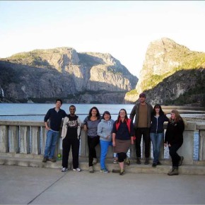
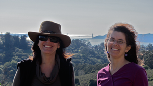
SF State University geographers stand atop O’Shaughnessy Dam, 312 feet above the submerged riverbed, pondering the dam’s future. (Nancy Wilkinson is near the center of the photo, fourth from the left.)
O’Shaughnessy Dam, named after City Engineer Michael O’Shaughnessy, dams the main stem of the Tuolumne River, storing up to 360,400 acre-feet of water.
Landscape painter Albert Bierstadt visited the Sierra in the 1860s and 1870s and found Hetch Hetchy Valley smaller than the more famous Yosemite Valley but quite as beautiful.
San Francisco had already begun a search for more abundant and reliable water supplies, culminating in a decade-long battle for federal permission to dam the Tuolumne River in the Hetch Hetchy Valley, within the borders of Yosemite National Park. Congress approved the right-of-way in late 1913; the valley was flooded by 1923. The $100 million project delivered water to San Francisco, via 148 miles of tunnels and pipelines. It continues to serve over 2.5 million people in San Francisco and nearby communities, and to provide hydroelectric power for the city’s airport, hospitals, streetcars and other public utilities.
The Hetch Hetchy project was widely credited with hastening the death of John Muir, the Sierra Club’s founder and the project’s fiercest opponent. It is still contested to this day. In 1987, Secretary of the Interior Donald Hodel proposed decommissioning the dam and restoring Hetch Hetchy Valley to expand recreational opportunities for Yosemite’s visitors. Hodel’s proposal caught The Sierra Club and other longtime foes of the water project off guard; they suspected Hodel was trying to discredit the Left Coast City’s environmentalist opposition to the expansion of offshore oil drilling.
Twenty-five years later, in 2012, San Franciscans rejected by 3:1 a ballot measure compelling the city to replace Hetch Hetchy water and power. Opponents argued that the water, power and fiscal benefits were impossible to replace and that restoring the drowned valley would cost billions in public funding. A group called Restore Hetch Hetchy continues the fight and has filed suit, contending that San Francisco’s water diversions violate the California constitution and that the value of restoring the valley exceeds the cost of moving the city’s Tuolumne River diversion downstream of the park boundary.
The most severe drought in historic times, now in its fourth year, has also called San Francisco’s water use into question. Although per capita consumption is among the lowest in the nation, San Francisco is one of the last coastal cities to adopt wastewater reuse programs, preferring to irrigate lawns and flush toilets with virgin snowmelt and to discharge wastewater to the bay and ocean. This is changing: in 2012, the city adopted an ordinance encouraging non-potable wastewater reuse by commercial, multi-family and mixed-use developments.
Efforts to raze the dam at Hetch Hetchy are not the biggest threat to San Francisco’s water supply. The Hetch Hetchy project, like so much of the California water system, relies on the state’s largest above-ground reservoir: the Sierra snowpack. Yet climate change models predict the Sierra will continue to receive an increasing share of its precipitation as rain rather than as snow, and that snowpack will melt earlier. This will necessitate runoff-capture projects to stabilize supplies. Meanwhile, we should anticipate more frequent droughts.
San Francisco, like every city, remakes the countryside around it. The gold rush city owes its early growth and prosperity to resource extraction. Denuded Sierra landscapes, bay fill, mercury contamination and decimated redwood groves join the drowned Hetch Hetchy valley as legacies of the first century of city-building. While San Franciscans may cherish nature and promote environmental restoration, they curiously “naturalize” Hetch Hetchy water, appreciating its pristine purity and the hydroelectricity it generates en route to the city. The Hetch Hetchy project – controversial, unsustainable – is a complex manifestation of the city’s conflicting progressive environmental sensibilities and its environmental history.
Nancy Wilkinson has been a Professor in the Department of Geography & Environment at San Francisco State University since 1986. Her teaching and research focus on California water resources and environmental perception.
Share
Post
The Coming ‘Dry-Wet Knockout’ in California
Frances Malamud-Roam on Petaluma Marsh, next to San Francisco Bay, with marsh sediment core.
Seven of the last 10 years have been dry in California, and the last four have been critically dry. The drought is a top concern for Californians, with two-thirds of the state in extreme to exceptional drought. Severe droughts are one feature of our state’s climate; extremely wet years are another. In fact, droughts and floods are two sides of the same coin, because often extremely wet winters have followed on the heels of severe and prolonged droughts. This coming winter, a major El Niño is predicted, and may bring heavy rains accompanied by flooding, mudslides, and landslides.
The coupling of prolonged droughts with extreme wet years has been dubbed a “dry-wet knockout” by climate scientists, who have found that these occur with unnerving frequency in California’s climate history. In just the past century we have seen several examples. The years between 1928 and 1937 were among the driest of the 20th century in California, desiccating the grasslands of the Central Valley and the slopes of the mountains, and shrinking rivers and lakes. Then the winter of 1937-38 saw a series of storms deluge the northern two-thirds of the state, including two storms that dumped 10 inches of rain in southern California, flooding areas from San Diego to Los Angeles and into the Mojave Desert.
This dry-wet scenario was repeated two decades later a drought in the early 1950s was followed by massive floods in 1955, particularly throughout the central Sierra Nevada and the San Francisco Bay region. In Orange County, warm rains melted snow in the San Bernardino Mountains, causing catastrophic flooding of the Santa Ana River. Two decades later, the climate coin flipped from the driest year on record, 1976-1977, to the torrential rains of 1977-1978. More recently, the prolonged drought of 1987-1992 was followed by the extremely wet winter of 1993.
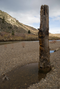
Medieval tree stump in the West Walker River (eastern California).
These scenarios are particularly stressful on local and regional ecosystems. They have been called “dry-wet knockouts” because drought weakens ecosystems, and the following floods deliver a “knockout” blow. Vegetation that holds the soil in place withers during droughts, and the soils desiccate and are more easily eroded. Forests become dangerously dry and susceptible to wildfires sparked by summer lightning strikes. Then the knockout: a winter with storm after storm spawned out over the Pacific slams into the west coast. Heavy rains easily erode the fire-charred slopes, washing massive amounts of sediment downhill, eventually choking streams and lakes. The sediments raise the bed-level of rivers, exacerbating floods. Once on the move, the slurry of sediment-laden waters disrupts downstream aquatic ecosystems in ponds, lakes, estuaries, and even the coastal ocean. Dry-wet knockouts become natural disasters for Californians, as economic losses due to drought are compounded by the subsequent devastation of deluges. Homes – sometimes entire neighborhoods – can be buried in massive mudslides; roads and highways buckle as the once-solid earth is eroded out from beneath them; agricultural fields are inundated and crops lost. The floodwaters can take months to finally drain.
What do the paleoclimate records tell us about these dry-wet knockouts? For one thing, they were not a unique phenomenon of the 20th century. Prolonged droughts are common, occurring once or twice per century. And every one to two millennia in California, climate shifts to a dry phase, or megadrought, lasting a century or longer. For instance, during the Medieval Warm Period, from 900 to 1350 A.D., precipitation in the region dropped to 60 percent of average and wildfires were 30 percent more frequent. Two distinct megadroughts occurred during the Medieval Warm Period, each lasting over 150 years, and each dramatically ending in megafloods. The megadroughts brought down flourishing civilizations, with archaeological evidence of malnutrition, infant mortality, violence, and warfare. Evidence of subsequent widespread knock-out megafloods is clear. For instance, tree stumps found in the middle of lakes in the southern and eastern Sierra Nevada are what remain of trees that grew for over a century during the prolonged medieval droughts and were suddenly drowned by heavy rains and huge floods. Hundreds of miles away, sediment cores collected from beneath the San Francisco Bay and its tidal marshes reveal evidence of megafloods immediately following the medieval droughts. Perhaps the largest knock-out megaflood occurred in AD 1605, after another decades-long drought. Floodwaters rushing through the Bay scoured the estuary and at the same time the sediment-rich floodwaters deposited thick layers of mud on the surrounding marshes.
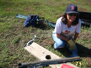
Frances Malamud-Roam, at left, with Lynn Ingram, at right, taking sediment cores from a small lake in the Sacramento River Valley.
The dry-wet knockouts seen in the paleoclimate record are of a much greater magnitude than what our 20th century experiences have been. The more comparable event in historic memory would be the deep drought of the mid-19th century, which peaked in 1860 and was followed by a series of large storms that flowed, one after another, across the Pacific during the winter of 1861-62. Recent research reveals that these were atmospheric river storms – narrow corridors of water vapor that originate over the tropical Pacific Ocean and travel thousands of kilometers to the West Coast, carrying up to 10 Mississippi Rivers worth of water. The Central Valley – 400 miles long and 50 miles wide – was turned into an inland sea in 1862, and Sacramento was submerged for months. Water planners considered the 1861-62 Flood a 1,000-year event, but the paleoclimate records suggest that floods of this magnitude recur every 100-200 years.
Today, many regions in California are even more vulnerable to flooding than during 1861-62. Viewed from above, the Central Valley looks like a giant bathtub, four hundred miles long and seventy miles wide, with San Francisco Bay Delta Estuary as the drain. The region’s population has swollen from 500,000 in 1861 to almost 39 million today, while in the Central Valley, housing developments are replacing agricultural lands in the floodplains. This growth has led to soil compaction, loss of wetlands, and subsidence, causing much of this vast region to literally sink – by as much as thirty feet in some areas. Today, the region is far more susceptible to flooding than it was during the 1861-62 floods. Floodwaters filling the Central Valley now would submerge major population centers instead of small towns, marshes and farmlands. Densely populated cities like Modesto, Fresno, Stockton, and Sacramento are protected by a relatively primitive network of fragile levees that serve as the only line of defense against floods on the Sacramento and San Joaquin rivers.
A warmer world will bring a drier climate to California – an inevitable consequence of higher evaporation rates and shifting storm tracks. But the underlying climate patterns producing dry-wet knockouts will not go away. In fact, it is likely that they will be exacerbated as more precipitation falls as rain than snow during the warmer winters, causing larger floods. At the same time, more evaporation over the tropical Pacific Ocean will spawn larger atmospheric river storms – the type of storms that bring the most flood-producing deluges to California. California needs to begin serious preparations now for both extremes: water scarcity, and larger floods, in the future.
Professor Lynn Ingram studies the history of climate change in California using sediment cores from lakes and estuaries, including San Francisco Bay. Dr. Ingram is a Fellow of the California Academy of Science, and is a Senior Fulbright recipient. She has been a Professor in the Departments of Earth and Planetary Science and Geography at UC Berkeley since 1995. She is the author of more than 60 published scientific articles on past climate change in California and the West.
Dr. Frances Malamud-Roam is a Senior Environmental Planner and Biologist at Caltrans. She received her B.A., M.A. and Ph.D in the Department of Geography at UC Berkeley, with research expertise in the origin of agriculture in China, the long-term evolution of salt marshes and estuaries along the Pacific Coast, and changing climate in California and the West. She has taught earth science and physical geography at Sonoma State University and Laney College.
Pacific Coast Division Team Takes 2015 World Geography Bowl Title
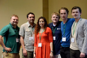
AAG Pacific Coast Regional Division 2015 World Geography Bowl Champions
The Pacific Coast team won first place in the 2015 World Geography Bowl, an annual quiz competition for teams of college-level geography students representing the AAG’s regional divisions. This was the 22nd year for AAG hosting during its annual meeting.
On April 24, nine teams, each representing an AAG regional division, competed at the Hyatt hotel in Chicago. All nine regional divisions were represented by a team: East Lakes, West Lakes, Great-Plains Rocky Mountains, Middle Atlantic, Middle States, New England-St. Lawrence Valley, Pacific Coast, Southeast and Southwest Divisions. A spoiler team comprised of students present at the competition was added to round out the brackets. One of the spoiler team members, fourth-grader Ari Vogel from Wildwood Elementary School in Amherst, Mass., even scored for the team.
At the beginning of the exciting competition AAG President Mona Domosh addressed the crowd with an uplifting message and at the end presented the winners with prizes.
The winning Pacific Coast Division team’s roster was:
Brendan Gordon, University of Idaho
Jesse Minor, University of Arizona
Noah Silber-Coats, University of Arizona
Laura Sharp, University of Arizona
Tina White (coordinator), Cypress College
The first runner-up Southeast Division team’s roster was:
Pete Akers, University of Georgia
Ronnie Schumann, University of South Carolina
Claude Buerger, University of South Alabama
Alejandro Molina, University of North Carolina- Greensboro
Rebecca Groh, University of Tennessee
Matt Cook, University of Tennessee
Dawn Drake (coordinator), Missouri Western State University
The second runner-up Middle Atlantic Division team’s roster was:
Christopher Hart, George Washington University
Kean Mcdermott, George Washington University
Madeline Hale, George Washington University
Michelle Stuhlmacher, George Washington University
Gloriana Sojo, George Washington University
Ziqi Li, George Washington University
Avery Sandborn, George Washington University
Tracy Edwards (coordinator), Frostburg State University
The top five individuals with best personal scores were awarded an MVP prizes. Listed in order of most points earned:
Christopher Hart, George Washington University
Pete Akers, University of Georgia
Kevin Bean, Bridgewater State University
Brendan Gordon, University of Idaho
Kate Rigot, University Of Colorado, Denver
WGB Founder and Retired Geographers Association members make a special appearance
As a special surprise to all, the founder of the World Geography Bowl Neal Lineback and other members of the Retired Geographers Association, including Richard and Susan Nostrand, Will Rense and Marvin Baker delivered eight boxes of delicious Chicago-style deep-dish pizza for the gathering crowd of contestants and audience members.
Thanks to 2015 WGB prize donors and volunteers
Organizers of the World Geography Bowl would like to express thanks to the countless volunteer question writers, team sponsors/coaches, moderators, judges, and scorekeepers who make the competition possible, and to the many students who competed throughout the country. We would like to recognize the volunteers this year as: Casey Allen (University of Colorado at Denver), Tom Bell (Western Kentucky University & University of Tennessee), Susan Bergeron (Coastal Carolina University), Michaela Buenemann (New Mexico State University), Laurence W. Carstensen (Virginia Tech), Jamison Conley (West Virginia University), Clinton Davis (Temple University), Richard Deal (Edinboro University), Lisa Dechano-Cook (Western Michigan University), Dawn Drake (Missouri Western State University), Rob Edsall (Idaho State University), Peggy Gripshover (Western Kentucky University), Tracy-Ann Hyman (University of the West Indies), Melvin Johnson (University of Wisconsin at Manitowoc), Frank LaFone (West Virginia University), Patrick May (Plymouth State University), Jon Moore (ETS), Jeffrey Neff (Western Carolina University), Lee Nolan (Pennsylvania State University), Colin Reisser (George Washington University), Wesley Reisser (US State Department & George Washington University), Angela Rogers (Pennsylvania State University), Zia Salim (California State University at Fullerton), Jodi Vender (Pennsylvania State University).
World Geography Bowl organizers thank its supporters who generously donated atlases, books, gift certificates, softwares, and MVP awards – Avenza Systems, The University of Chicago Press, The University of Georgia Press, Edward Elgar Publishing, Esri, Lonely Planet, MaxQDA, National Geographic Society, W. H. Freeman & Company and Waveland Press – who recognize the important role the competition plays in building a sense of community and generating excitement around geographic learning. Your continued support is truly appreciated.
Thanks to World Geography Bowl executive director Jamison Conley (West Virginia University) for his first year of leading the competition.
2016 World Geography Bowl – San Francisco
The 2016 World Geography Bowl competition will be held in San Francisco in April, 2016. Regional competitions typically occur during the fall at respective AAG regional meetings, where regional teams for the national competition are usually formed. For more information on organizing a team, contact the World Geography Bowl executive director, Jamison Conley, at West Virginia University at Jamison [dot] Conley [at] mail [dot] wvu [dot] edu or Niem Huynh at nhuynh [at] aag [dot] org.
Note: This post has been edited to reflect that it was the 22nd annual event. A previous version stated it was the 26th annual event.
Share
Annual Meeting
AAG 2015 Chicago Annual Meeting PDF Program
Share
Post
Symposium on Physical Geography Features Experts on Environmental Reconstruction
A special event at this year’s AAG annual meeting is the all-day Symposium on Physical Geography, scheduled for Thursday, April 23. The overall goal of the symposium is to facilitate and enhance dialog on emerging developments, challenges, and approaches related to physical geography. Morning oral sessions, organized around the theme “Environmental Reconstruction – A Nexus of Biogeography, Climatology and Geomorphology”, are followed in the afternoon by an extended poster session with over 200 posters on display, and a networking reception and Happy Hour from 4:30 p.m. – 7:30 p.m. All AAG attendees are invited to participate in the Symposium on Physical Geography. Please contact organizers Julie Winkler (winkler [at] msu [dot] edu), Carol Harden (charden [at] utk [dot] edu), or Richard Marston (rmarston [at] ksu [dot] edu) with questions.
The invited speakers for the morning oral sessions are leading experts on environmental reconstruction, whose expertise ranges from the study of past climates, landscapes, and biological systems to the reclamation of altered environments. The speakers and the titles of their presentations are:
Johannes J. Feddema: Modeling the Anthropocene: Potential contributions from Physical Geographers
Dr. Feddema is professor and chair of the Geography Department at the University of Kansas. He obtained a Ph.D. degree in Climatology from the University of Delaware and his research interest is primarily in studying the processes by which anthropogenic actions affect climate. His current research combines remote sensing, GIS, and modeling to develop datasets to simulate land cover change and other human processes at the Earth’s surface in the National Center for Atmospheric Research (NCAR) Community Climate System Model (CCSM). He has published in a variety of journals including Climate Research, Climate Dynamics, Climatic Change and Science, and was a contributing author to the third and fourth IPCC reports.
Melinda D. Daniels: Reconstructing River and Watershed Restoration: Physical Geography and a New Restoration Design Science
Dr. Daniels holds a B.S. in Natural Resources from Cornell University, a Masters of Research in Environmental Science from University College of London, England, and a Ph.D. in Physical Geography from the University of Illinois at Urbana-Champaign. Her specialties include fluvial geomorphology and river restoration science and policy, with emphases on in-channel flow hydraulics, large river planform dynamics, human impacts on hydrologic and geomorphic regimes, river restoration assessment, and the interconnections between hydro-geomorphologic and ecological processes in stream ecosystems. She has studied river systems in the Great Plains, Rocky Mountains, Midwest and the Northeast. Her current research program focuses on legacy land use disturbances, effects of grassland grazing and burning treatments on stream morphology and sediment transport dynamics, the effects of forest loss on woody debris dynamics, modeling impacts of climate change on coupled human-watershed systems, and long term research on the hydro-ecological effects of watershed restoration. Before joining the Stroud Water Research Center, she was a tenured professor at Kansas State University.
Markus Stoffel: Mass movements from periglacial environments — Studying tree rings to put the impacts of current climate warming into perspective
Dr. Stoffel is a Professor of Geomorphology and currently works at the Institute for Environmental Sciences (ISE), University of Geneva and at the Institute of Geological Sciences, University of Berne (Switzerland), where he also directs dendrolab.ch. His research interests are in hydrogeomorphic and earth-surface processes, large volcanic eruptions, climate change impacts, biodiversity, tree physiology, and dendroecology. Books that he has edited or co-edited include Tree Rings and Natural Hazards (Springer 2010), Tracking Torrential Processes on Fans and Cones (Springer, 2012), and Treatise on Geomorphology: Mountain and Hillslope Geomorphology (Elsevier, 2013). Professor Stoffel holds B.Sc. and M.Sc. degrees in Physical Geography, a M.Sc. degree in Media and Communication Sciences, and a Ph.D. in Dendrogeomorphology from the University of Fribourg (Switzerland), as well as a habilitation thesis degree (venia docendi) from the University of Berne (Switzerland). In 2010, he received an honorary professorship (Prof. honoris causa) in Physical Geography at Babeş-Bolyai University (Romania).
Robert A. Washington-Allen: Retrospective Analysis of U.S. Dryland Carbon Dynamics
Dr. Washington-Allen is an assistant professor in the Department of Geography at the University of Tennessee. He has an abiding interest in pastoralists and the sustainability of drylands. His remote sensing-based drylands research has taken him around the world, most recently to southern Ethiopia and Jordan, with side excursions to Tropical Cloud Forests and the Paramo peatlands of Colombia. Dr. Washington-Allen currently serves as the Chair of Remote Sensing & GIS Committee of the Society for Range Management and on the U.S. Global Change Research Program National Climate Assessment’s Grasslands, Rangelands, & Pastures Indicators Technical Team. He has contributed to the U.S. Forest Service’s 2010 Resource Planning Act (RPA) Assessments: A synoptic review of U.S. rangelands: A technical document supporting the Forest Service 2010 RPA Assessment and Future of America’s Forest, and Rangelands: Forest Service 2010 Resources Planning Act Assessment.
Kristine DeLong: Reconstructing Tropical Climate Variability from Massive Corals
Dr. Kristine DeLong is an Assistant Professor in the Department of Geography and Anthropology at Louisiana State University. She received her Ph.D. in Marine Science from the University of South Florida and completed post-doctoral research at the U.S. Geological Survey in St. Petersburg, FL. Professor DeLong’s research is focused on climate change of the past, primarily in the subtropics to tropical regions for the past 120,000 years. She is also concerned with the refinement, fidelity, and data analysis methods used in paleoclimate reconstructions. She has participated in international projects including the Integrated Ocean Drilling Program (IODP), PAGES 2K, and the Marine Annually Resolved Proxy Archives (MARPA), as well as the South Central Climate Science Center funded by the U.S. Department of the Interior.
Bette L. Otto-Bliesner: African Rainfall and Greenhouse Gases: A Lesson from the Past
Dr. Bette Otto-Bliesner is a Senior Scientist at the National Center for Atmospheric Research (NCAR) in Boulder, Colorado, and serves as head of NCAR’s Paleoclimate Modeling Program. As a nationally and internationally recognized expert in using computer-based models of Earth’s climate system to investigate past climate change and climate variability across a wide range of time scales, she has been involved in the IPCC Working Group I reports since the Third Assessment, and was a Lead Author for the IPCC AR4 and AR5. She served as the Chair of the International Geosphere-Biosphere Programme (IGBP) Past Global Changes (PAGES) and is currently Co-chair of the Community Earth System Model (CESM) Paleoclimate Working Group. She is a member of the Scientific Steering Committee for the Paleoclimate Modeling Intercomparison Project (PMIP), the group that coordinates international climate model experiments addressing past climate change relevant to understanding future change. She was born in Chicago and received her Ph.D. in Meteorology from the University of Wisconsin-Madison.
Share
Post
Chicago: Food City
In 2011, Michelin released its first “red” guide to Chicago restaurants and hotels. Chicago became the third city in the United States, after New York and San Francisco, to have a red guide. To some, this may seem like a minor matter, but the red guide is a marker of culinary excellence for gourmets, and its release was a sign of how important of a destination Chicago has become for culinary tourists.
High-end restaurants have bloomed in Chicago in the past 20 years. Current tourists come to experience places like the molecular gastronomy temple Alinea, currently listed by one source as the ninth best restaurant in the world. Chef Grant Achatz takes apart foods into basic components, and reconstructs them into beautiful (and very expensive) concoctions. Grant Achatz’s other restaurant, Next, features a new cuisine every few months. Like Alinea, one buys pre-paid “tickets” rather than making reservations. At Next you can buy season tickets for the various incarnations of the restaurant, in the same way you purchase a theater subscription (hint for AAG gourmands, if you sign up to their Facebook page, a couple of tables usually are available each day). Other places such as Avez, the Gage, Girl and the Goat, and Publican feature Midwestern ingredients especially house-cured meats.
While these high-end restaurants may bring tourists to the city, Chicago is as least as famous for its hearty everyday foods. These include the Chicago hot dog, topped with mustard, tomatoes, grilled or raw onions, a pickle spear, “sport” peppers, and celery salt, and the even heartier Italian beef, a roasted beef sandwich somewhat like a French dip, served on Italian bread, and topped with hot or sweet pepper. It is particularly delicious dipped back into the gravy. Both of these sandwiches grew out of the Depression years, providing a cheap meal to hungry Chicagoans. The World War II era saw the invention of the deep-dish pizza, a similarly hearty meal in one dish (and one slice). Later, Chicago was the site of the invention of the gyro sandwich (at least the ground lamb and beef on a rotating skewer variety), and more recently, the Puerto Rican jibarito, a steak sandwich served between two mashed and fried plantain slices (vegetarian and other varieties are now also available).
Chicago is not a food city just because of the food that is served here. From its beginning, Chicago has been a place that processed, stored, and sold the ingredients of the Midwest. Chicago was the US capital of industrial candy manufacturing, home or former home to Brach’s, Mars, Toostie Roll, Curtiss Candies (makers of Baby Ruth and Butterfinger bars), Wrigley’s gum, and many others. While many of these plants and companies are now gone, the Mars plant still makes candy on the far west side, and Tootsie Roll is still on the southwest side. Nestlé bought Curtiss Candies but manufactures candy bars in the same plant as before, just south of O’Hare airport. Still today, if you take a walk west along the north bank of the Chicago River, past the Merchandise Mart, and then cross the north branch of the river at Kinzie, you may start smelling chocolate. This comes from Blommer’s, the largest processor of chocolate in North America, and supplier to many other manufacturers, which is located just beyond the river.
Probably the most famous Chicago sites related to industrial food are the Chicago Board of Trade and the Chicago Union Stockyards. The Board of Trade began as an association of grain buyers and sellers who traded along the south bank of the Chicago River, but soon developed into the largest grain exchange in the world. It is now part of CME Group, having merged with the once much smaller Chicago Mercantile Exchange, which itself began as the Chicago Butter and Egg Board. The Board of Trade Building, located prominently at the south end of the LaSalle Street urban canyon, is worth a tour. Topped by a faceless statue of Ceres, the Roman god of grain, the Arc Deco building’s interior is filled with sculptural allegories to grain. The Chicago Union Stockyards closed in 1971, but the stockyards area, on the near southwest side, still hosts one meatpacker, and The Plant, a vertical farm and food business incubator, which at the moment includes a kombucha manufacturer, two aquaponics companies, a bakery, and a sustainable indoor prawn farm.
The Plant is one example of how urban agriculture has been growing in the Chicago area. Others include two for-profit large-scale aqauponics facilities, non-profit urban farms including the Chicago branch of Milwaukee based Growing Power, and Growing Home, a work-training program in the Englewood neighborhood, and many others. Community gardens now dot many Chicago neighborhoods. While this may all seem new, in many ways it brings the city back to its roots. Much of Chicago was once a swamp, but after being drained, much of it was also very good agricultural land. Sandy Lake View was once a leading producer of celery. What is now the South Side was a produce producing area, and part of the North Side was covered with greenhouses, producing flowers and other plants for the city. The area near O’Hare (once called Old Orchard) was a farming zone, also largely producing for the city, but also producing peas and other vegetables for canning by Chicago-based Libby’s.
At its very beginning, the town of Chicago was consisted of collection of taverns and houses that were built between 1829 and 1833 around “Wolf Point,” at the confluence of the North and South branches of the Chicago River. The most famous of these was the Sauganash Hotel, where proprietor Mark Beaubien would play the fiddle while townsfolk and hotel patrons danced. Hearty food was served. Today, the flow of the river has been reversed, and the river is wider, but Chicago still is a place that welcomes its visitors with hearty food and good cheer, as well as more gourmet possibilities. Enjoy your time in our city and eat well.
Author-Meets-Critics: David Harvey’s ‘Seventeen Contradictions and the End of Capitalism’
In his newest book, Seventeen Contradictions and the End of Capitalism (Oxford, 2014), David Harvey sets out to understand not the contradictions of capitalism, but those of capitalism’s economic engine: capital. He wants to uncover how and why capital works the way it does and “why it might stutter and stall and sometimes appear to be on the verge of collapse. [He] also want[s] to show why this economic engine should be replaced, and with what.”
This author-meets-critics panel brings Harvey into conversation with several important figures in contemporary Marxist geography to discuss this book in particular and Harvey’s significant contribution to radical geography more generally. Remarks from this panel will subsequently appear as a Review Symposium in the journal Human Geography.
Panelists will include Ipsita Chatterjee, Elaine Hartwick, Don Mitchell, Dick Peet, Sue Roberts, and Erik Swyngedouw. David Harvey will also be present to respond to the critics and take questions from the audience.
Author-Meets-Critics: David Harvey’s Seventeen Contradictions and the End of Capitalism
Wednesday, April 22, 2015, 3:20 p.m.
Grand C/D North, Hyatt, East Tower, Gold Level
Share
Register for Free
Create an account to get free access to exclusive AAG content.
AAG Members get exclusive access to publications, prominent journals, unique advocacy, grant, scholarship and professional opportunities with access to industry focus communities, and event discounts, including our annual meeting.
Some content may only be accessible if you belong to specific Specialty or Affinity Groups. You can still update your membership below. You will need to go through the Join flow, but you do not need to repurchase your membership unless it is expired or about to expire.
To provide the best experiences, we use technologies like cookies to store and/or access device information. Consenting to these technologies will allow us to process data such as browsing behavior or unique IDs on this site. Not consenting or withdrawing consent, may adversely affect certain features and functions.
Functional
Always active
The technical storage or access is strictly necessary for the legitimate purpose of enabling the use of a specific service explicitly requested by the subscriber or user, or for the sole purpose of carrying out the transmission of a communication over an electronic communications network.
Preferences
The technical storage or access is necessary for the legitimate purpose of storing preferences that are not requested by the subscriber or user.
Statistics
The technical storage or access that is used exclusively for statistical purposes.The technical storage or access that is used exclusively for anonymous statistical purposes. Without a subpoena, voluntary compliance on the part of your Internet Service Provider, or additional records from a third party, information stored or retrieved for this purpose alone cannot usually be used to identify you.
Marketing
The technical storage or access is required to create user profiles to send advertising, or to track the user on a website or across several websites for similar marketing purposes.


 As a special surprise to all, the founder of the World Geography Bowl Neal Lineback and other members of the Retired Geographers Association, including Richard and Susan Nostrand, Will Rense and Marvin Baker delivered eight boxes of delicious Chicago-style deep-dish pizza for the gathering crowd of contestants and audience members.
 Johannes J. Feddema: Modeling the Anthropocene: Potential contributions from Physical Geographers
 Melinda D. Daniels: Reconstructing River and Watershed Restoration: Physical Geography and a New Restoration Design Science
 Markus Stoffel: Mass movements from periglacial environments — Studying tree rings to put the impacts of current climate warming into perspective
 Robert A. Washington-Allen: Retrospective Analysis of U.S. Dryland Carbon Dynamics
 Kristine DeLong: Reconstructing Tropical Climate Variability from Massive Corals
 Bette L. Otto-Bliesner: African Rainfall and Greenhouse Gases: A Lesson from the Past