Session Commemorating William Garrison To Follow Presentation of Garrison Award

Garrison Award & Tribute Sessions
3:20 p.m.–7:00 p.m., Thursday, March 31, 2016

An award session to present the paper selected for the William L. Garrison Award for Best Dissertation in Computational Geography will be held at 3:20 p.m. on Thursday, March 31, 2016, at the AAG Annual Meeting in San Francisco. Stéphane Joost, a former Garrison awardee and current Garrison Committee Member, will also deliver a presentation, “The geographic dimension of genomic diversity: from genome scans to whole-genome sequence data.”

Memorial presentations will follow the award segment of the session to commemorate Garrison’s life and work in geography. Brian J.L. Berry, Duane F. Marble, and Elizabeth Deakin will lead the talks. The session will conclude with a reception, permitting assembled participants and guests to pay tribute to and share their reminiscences of Bill.

William Louis “Bill” Garrison, one of the leaders of geography’s “quantitative revolution” in the 1950s and an outstanding transportation geographer, died last year on February 1, 2015, at the age of 90. The Garrison Award, which was named for Bill, supports innovative research into the computational aspects of geographic science. This award is intended to arouse a more general and deeper understanding of the important role that advanced computation can play in resolving the complex problems of space–time analysis that are at the core of geographic science. The award is one of the activities of the Marble Fund for Geographic Science of the American Association of Geographers (AAG).

    Share

Rebecca Solnit: ‘Mapping the Infinite City’ — A talk on the ‘infinite trilogy’ of atlases

Rebecca Solnit (credit: Shawn Calhoun, CC)

Rebecca Solnit & Joshua Jelly-Schapiro: Mapping the Infinite City

Wednesday, March 30 from 5:20 p.m. – 7:00 p.m.
San Francisco, CA (Room TBD)

When the trilogy Rebecca Solnit and a host of collaborators launched in 2010 with Infinite City: A San Francisco Atlas concludes with the New York atlas co-directed by geographer Joshua Jelly-Schapiro, the teams will have produced three books and 70 maps making postulates about both the nature of cities and the possibilities of contemporary cartography.

This talk will explore what maps can do, or at least what these particular maps do, the ways these projects are counters to the rise of digital navigation and celebrations of what maps did in other eras, and how cartography lets us grasp or at least gaze at the inexhaustibility of every city, the innumerable ways it can be mapped. Session details forthcoming.

Solnit is also the author of several popular books, including Wanderlust, A Field Guide to Getting Lost, The Faraway Nearby, River of Shadows: Eadweard Muybridge and the Technological Wild West, Men Explain Things to Me, The Encyclopedia of Trouble and Spaciousness, among many others. Her writing has also appeared in The New Yorker, The Guardian, and Harper’s, to name a few. She has worked on environmental and human rights campaigns since the 1980s, specifically climate change and women’s rights, including violence against women.

    Share

Bay Area Open Space Is ‘Not’ Open Space

The San Francisco Bay Area has more open space within its borders than any other metropolitan area in the United States, an intriguing state of affairs for a regional population approaching nine million people. While so much open space provides a scenic landscape and exceptional opportunities for outdoor recreation including hiking, biking, horseback riding, and hang gliding, it also supports the area’s most prevalent land use. From Santa Clara to Sonoma County — on private lands, regional parks, on habitat conservation and watershed lands — cattle ranching continues as the number-one land use in this famed tourist destination and hotbed of the knowledge economy and high tech industry. Whether the working ranches are on public or private land, many Bay Area ranchers represent a fourth, fifth, or sixth generation stewarding the land and their livestock, drawing on older traditions and practices of pastoralists and primary producers. Ranching or working rangelands describe the land use of over 1.7 million acres of the Bay Area’s 4.5 million acres of open space (PlanBayArea.org). Rangelands that produce both livestock products and ecosystem services are known as “working landscapes” in the Bay Area (Fig 1).

Fig 1: A hiker takes a landscape of grazing cattle, wildflowers, and broad views, walking through prime Checkerspot Butterfly habitat, Coyote Ridge, south of San Jose, California. (Photograph by Sheila Barry)

Ranching supports the Bay Area’s incredible biological diversity at the landscape and pasture level. Thirty-three percent of California’s natural communities are found in the Bay Area on only five percent of the state’s land, which makes this one of the nation’s most important biological hot spots (Bay Area Open Space 2012). At the landscape level, ranching maintains extensive open landscapes that were originally grassland or a tree-grass mosaic shaped by the burning practices of native Californians (Fig 2) (Diekmann et al. 2007). Oaks that are the most common native tree provide abundant acorns and rich game habitat. Spanish-Mexican colonists used the grasslands and woodlands for extensive livestock grazing well into the 1840s, and established some of the largest ranches in California. The Pt. Reyes National Seashore derives from what was originally a Mexican land grant.

Fig 2: Working landscapes make up a substantial portion of the San Francisco Bay area, as evident in this 2015 map by the California Rangeland Trust.

Large patches of open grazed grassland support a species-rich birdlife community, including along the southern range a slowly recovering population of the California Condor (Gymnogyps californianus). At the pasture level, ranching provides for biodiversity through grazing and associated rancher stewardship. Grazing reduces annual plant biomass, influences vegetation composition, affects vegetation structure, and provides the patches of bare ground needed by some species, such as the Ohlone tiger beetle (Cicindela ohlone) (Cornelisse et al. 2013). The endangered Bay checkerspot butterfly (Euphydryas editha bayensis), California tiger salamander, burrowing owls (Athene cunicularia), and kit fox (Vulpes macrotis mutica) all benefit from livestock grazing, which manages vegetation and preserves needed habitat (Bartolome et al. 2014). In fact, the exclusion of grazing has resulted in the extirpation of some populations of these species from “protected sites” (Barry et al. 2015). Rancher stewardship includes development and maintenance of livestock water sources including stock ponds, pest management, debris clean-up, and forage improvement. In the San Francisco Bay region, ponds developed for livestock water provide half of the available habitat for the endangered tiger salamander (Ambystoma californiense).

Despite being the area’s most prevalent land use, cattle ranching largely goes unnoticed by much of the public. Ranching operations typically need up to 15–20 acres per cow per year. Few people realize that many of the Bay Area’s open spaces are managed with grazing until they come on to cattle grazing in a regional park. While there is support for ranching as a way of life with long traditions, the management of vegetation that without grazing could prove a fire hazard is a shared goal, brought starkly to light by the Oakland-Berkeley firestorm of 1991 that killed 25 people and destroyed some 3,300 dwellings at a cost of more than $1.5 billion. Today, significant areas of the 8,180 acre Stanford University campus are grazed for vegetation control, as are upper reaches of the 1,232 acres UC Berkeley campus, often by hired goat herds (Stein 2015).

Bay Area ranchers are particularly aware of the public’s interest in the rangelands they manage (Fig 3). At least partly because they often rely on leases from parks and conservation lands to complement their private holdings, many ranchers have learned to manage for native plant and animal species and fire hazard control. The California Rangeland Conservation Coalition, a statewide group focused on bringing ranchers, scientists, environmentalists, range professionals, and agencies together to support ranching and the conservation of grazing lands, enjoys strong support among Bay Area ranchers (https://carangeland.org). Working landscapes are also a prominent part of the Bay Area’s “foodscape,” widely appreciated by food-conscious Bay Area residents. On privately-owned ranch lands, ranchers use wildlife-friendly practices and improvements, sometimes partnering with the Natural Resources Conservation Service, the California Department of Wildlife, or local Conservation Districts. Many have mitigation or conservation easements on their properties, providing more habitat, watershed, and connectivity than can be provided on public lands alone.

Fig 3: Rancher Ned Woods grazes cattle on East Bay Park land, near Mt. Diablo and Walnut Creek, California. (Photograph by Lance Cheung, NRCS, USDA)

A recent study used social media to understand public interest and perceptions of cattle grazing on parklands (Barry 2014). Many park users visiting Bay Area grazed parks shared positive views about cows and grazing on Flickr™ expressing an enjoyment of the pastoral scene and their recognition the grazing animals as “happy cows.” A few negative comments (under two percent) made it clear that some park users, especially those with dogs, are bothered by manure. Of greater concern to park managers, some park users expressed a fear of cows. Some stated a desire to overcome their fear but there seemed to be uncertainty about what could happen or how to respond to the presence of livestock. If you run across cattle on your Bay Area wanderings, give them their space, and keep dogs far away, since to livestock a dog is a predator. Cows really just want to eat the grass and will generally ignore you if you let them. Park managers may be able to overcome negative perceptions and fear of cows on public lands via education. With over 2.5 million visitors to grazed parks per year in the Bay Area, there is a growing opportunity to educate and explain why Bay Area open space is not open space but instead, constitutes well-stewarded places supporting and benefiting from cattle and sheep ranching.

Further Reading and References

Barry, S. (2014). Using Social Media to Discover Public Values, Interests, and Perceptions about Cattle Grazing on Park Lands. Environmental Management 53: 454-464. DOI: 10.1007/s00267-013-0216-4

Barry, S., L. Bush, S. Larson, and L. Ford. (2015). Understanding Working Rangelands: The Benefits of Livestock Grazing California’s Annual Grasslands. University of California ANR Publication 8517. 7 p.

Bartolome, J., B. Allen-Diaz, B., et al. (2014). Grazing For Biodiversity in California Mediterranean Grasslands. Rangelands 36(5): 36-43. DOI:10.1525/california/9780520252202.003.0020

Bay Area Open Space Council. (2012). Golden Lands, Golden Oppoturnity. Prserving vital Bay Area lands for all Californians. Accessed Nov 2015.

Cornelisse, T. M., M.K. Bennett, & D. K. Letourneau. (2013). The Implications of Habitat Management on the Population Viability of the Endangered Ohlone Tiger Beetle (Cicindela ohlone) Metapopulation. PLoS ONE8(8), e71005. DOI: 10.1371/journal.pone.0071005

Diekmann, L., L. Panich, and C. Striplen. (2007). Native American Management and the Legacy of Working Landscapes in California. Rangelands 29 (3): 46-50. DOI:10.2458/azu_rangelands_v29i3_diekmann

PlanBayArea.org [Association of Bay Area Governments and the Metropolitan Transportation Commission]. (2013). Plan Bay Area 2040 Draft Environmental Impact Report. Accessed Nov 2015.

Stein, D. and Facebook. 2015. Moving Goats on UC Berkeley Campus, Video Clip,


Sheila Barry is Bay Area Natural Resources/Livestock Advisor and Santa Clara County Director for UC Cooperative Extension

Paul F. Starrs is Professor of Geography, University of Nevada, Reno

Lynn Huntsinger is Professor, Environmental Science, Policy, and Management, UC Berkeley

DOI: 10.14433/2016.0002

    Share

Judith Butler To Give Plenary Talk at 2016 AAG Annual Meeting

Judith Butler, professor at the University of California at Berkeley, will give a plenary talk about “Demography in the Ethics of Non-Violence” at the 2016 AAG Annual Meeting on March 29 in San Francisco.

This high-profile session will focus on a principled approach to non-violence that often admits to exceptions where violence is conceded as legitimate. To what extent does the exception to nonviolence in the name of self-defense or for close kin implicitly make a distinction between lives worth saving and dispensable lives? A practice of non-violence has to take into account the demographic distribution of grievability that establishes which lives are worthy of safeguarding, and which are less worthy or not worthy at all. Otherwise, both biopolitics and the logic of war can permeate calculations about when and where non-violence can be invoked. Does the demographic challenge revise our approach to non-violence? and if so, how?”

Butler, the Maxine Elliot Professor in the Department of Comparative Literature and Program in Critical Theory, has advocated lesbian and gay rights movements and has been outspoken on many modern political matters. Two of her influential books, Gender Trouble: Feminism and the Subversion of Identity and Bodies That Matter: On the Discursive Limits of Sex, challenge notions of gender and develop her theory of gender performativity, which is now a prominent position in feminist and queer scholarship. Butler studied philosophy at Yale University where she received her B.A. and her Ph.D.

During her session, she will receive the 2016 AAG Honorary Geographer Award recognizing her foundational contributions to feminist and queer theory, cultural studies, and feminist and moral philosophy. Her work has transformed the ways in which scholars have understood gender and sexual identities and has thus fundamentally reshaped the theoretical underpinnings of the social and the spatial.

As such, her continuing interrogations of identity and subjectivity have inspired and informed feminist geography, queer, critical, and political theory in geography, and sexuality and space studies. In addition, as a political academic and activist she has served as a role model for many geographers who understand the deep entanglements of the academic and the political. This award, therefore, acknowledges her fundamental role in shaping geographic practices, theories, and actions.

Every year the AAG bestows its Honorary Geographer Award on an individual to recognize excellence in the arts, research, teaching, and writing on geographic topics by non-geographers. Previous awardees have included sociologist Saskia Sassen, architect Maya Lin, economist Jeffrey Sachs, biologist Stephen J. Gould, political scientist Cynthia Enloe, Nobel Laureate Paul Krugman, neuroscientist Nora Volkow, and authors Calvin Trillin, Barbara Kingsolver, and Barry Lopez.


    Share

David Lowenthal To Speak at 2016 AAG Annual Meeting

Thirty years after his classic book, The Past Is a Foreign Country, David Lowenthal explores anew how we celebrate, expunge, contest and manipulate the past. In his major new work, The Past is a Foreign Country – Revisited, he reveals the past as an almost entirely new realm, so transformed over three decades as to demand an equally new book.

During a special AAG “Author Meets Critics” session at the 2016 AAG Annual Meeting in San Francisco, Lowenthal will talk about his new book, while panelists Diana K. Davis, UC Davis; Marie D. Price, George Washington University; and Dydia Delyser, CSU Fullerton, give their understandings and opinions on the new book.

David Lowenthal from the Department of Geography, University College LondonAbout the author

David Lowenthal is emeritus professor of geography and honorary research fellow at University College London. He is a gold medalist of the Royal Geographical, the Royal Scottish Geographical and the American Geographical Societies, a Fellow of the British Academy and honorary D.Litt. Memorial University of Newfoundland. In 2010 he was awarded the Forbes Lecture Prize by the International Institute for Conservation. His books include The Heritage Crusade and the Spoils of History (1996), George Perkins Marsh, Prophet of Conservation (2000) and The Nature of Cultural Heritage and the Culture of National Heritage (2005).

    Share

San Francisco, on the Golden Edge

The AAG returns to San Francisco for its annual gathering in 2016, our fourth visit following successful meetings there in 1970, 1994, and 2007. Given the unique strengths of geospatial science for the synthesis of human, physical, economic, historical, demographic, and other elements into a composite picture, the San Francisco Bay Area is a rich setting for our meeting. A “golden edge,” that sits in a cradle of faults aligned along the margins of two of Earth’s vast plates—the North American and Pacific. Evolving through a colorful history plated with wealth from a sequence of economic booms, beginning with gold and silver, then railroads, land development, oil, and war industries, on into aerospace, and the computer era. San Francisco is a place on the edge in many ways, setting styles, tones, and motifs that season our life and times.

Figure 1: San Francisco, California, looking north across the city to the Marin headlands. (Photo by Bobbé Christopherson.)

At this time in geologic history, in absolute motion, the North American Plate progresses westward pressing against a Pacific Plate that moves northwestward. Yet, the relative motion of faults along the San Andreas system is right-lateral (one side is moving to the right relative to the other side), in a series of strike-slip faults. Crustal plates do not glide smoothly past one another. Instead, tremendous friction exists along plate boundaries, where stress (a force) builds strain (a deformation) in the rocks until friction is overcome and the sides along plate-boundary edges suddenly break loose in an earthquake along a fault line (see: https://earthquake.usgs.gov/).

On April 18, 1906, at 5:12 A.M., nearly 400 km (248 miles) of plate boundary snapped into new positions releasing a magnitude (M) 7.9 earthquake. This long seismic event, some 110 seconds in duration, killed 3000 people and caused more than a billion dollars in damage (correct estimates)—exact numbers may never be known because of the post-quake public relations machinery. This great quake caused fires, cracked brick cisterns of badly needed water, and led to near-complete devastation of a major U.S. city that was populated by 400,000 people.

The San Francisco quake triggered the exhaustive Lawson Report, chaired by Andrew Lawson, U.C. Berkeley, which broke much new ground in seismology (The California Earthquake of April 18, 1906: Report of the State Earthquake Investigation Commission: Carnegie Institution of Washington Publication 87, 2 vols.). In the report, the elastic-rebound model described the horizontal nature of faulting in the 1906 event. The response of soft mud and landfill and liquefaction, as compared to sand/gravel, and bedrock bases was mapped. Many lessons were laid out for politicians, academics, and the public (see: https://earthquake.usgs.gov/regional/nca/1906/).

Figure 2a: 1906 fence offset of 2.6 m (8.5 ft) northwest of Woodville, Marin County, showing the right-lateral horizontal movement along the fault line. (Photo from USGS Library.)

As financial and political interests looked ahead from their 1906 vantage point, a collective fear was that the earthquake would forever taint San Francisco. In contrast, after the great 1871 fire in Chicago, the city was rebuilt and better fire-fighting capabilities harnessed. However, what do you do with an earthquake threat? The region around San Francisco experienced major quakes in 1838 and 1868 and no one knew what was to come. For the bulk of the twentieth century following 1906, underreporting death counts and destruction was standard procedure, incorrect estimates of 700 dead and $250 million in damage the fictional report. Corrected estimates were finally published in 1989, ending 83 years of false numbers.

A deliberate decision was made to put up a smokescreen and talk of the great “San Francisco Fire” as the primary event in 1906, and for years it was called “the great fire,” with excess smoke cartooned on B&W photos to sell the label. A century of growth and progress ensued—landfill replaced about half of the surface area of San Francisco Bay to create new real estate, building height restrictions were waved, and growth crawled across known fault zones. The region was all set for the third game of the 1989 Baseball World Series between the San Francisco Giants and Oakland Athletics.

As the players warmed up and sportscasters exercised their voices, disaster struck at 5:04 P.M. (PDT), as a M 7.0 quake rocked the region and Candlestick Park. Areas of landfill around the bay, mapped in the 1908 Lawson Report, failed. The soft muds under a 2 km (1.2 mi) portion of the Route 880 Cypress freeway structure collapsed killing 42 people—unsuspecting victims, listening to the baseball preliminaries on their car radios (Figure 3). A section of the critical San Francisco–Oakland Bay Bridge fell, adding to the combined total damage of $8 billion across the region. The Loma Prieta quake was unique, for as the broadcast signal resumed, a global audience watched the events unfold. Overall, 67 people died in the region.

    Share

A Taste of New Deal Alphabet Soup in San Francisco

One of several controversial panels at Coit Tower. A library scene painted by Bernard Zakheim, in which patron (fellow muralist John Langley Howard) pulls a copy of Das Kapital from the shelf. Photo: Shaina Potts for the Living New Deal. Mural: Bernard Zakheim

Coming to San Francisco for the annual meeting next spring will mean inevitably traversing a landscape transformed by the New Deal. For those landing at the San Francisco or Oakland Airports, The Works Progress Administration (WPA), Public Works Administration (PWA), and State Emergency Relief Administration (SERA) all had a hand in their growth into major airports. Crossing over the majestic western span of the Bay Bridge is to rely on the New Deal as well. In 1936 when it was completed at the hands of the WPA, the bridge was the longest suspension bridge in the country. From the bridge, many visitors quickly pick out one of the city’s most visible landmarks, Coit Tower, where the entire interior is covered in New Deal frescos. With funds from the Public Works of Art Project (PWAP), the New Deal’s first public arts program, twenty-six artists spent six months in 1934 creating murals of depression era life and the state’s history. The murals were carefully restored last year and are once again on view to the public as a monument not just to California but a historical moment when the federal government invested directly in the arts, infrastructure and its poorest citizens.

Pieces of San Francisco’s history, like that of Coit Tower, are relatively well known. But the extent of the structural and aesthetic improvements made to the city are just now being recovered by a team of researchers and volunteers at the Living New Deal project. Founded and directed by Berkeley Geographers Richard Walker and Gray Brechin (a longer history of the project is available on our website), the Living New Deal works to rediscover, catalog and map the sites of New Deal art and infrastructure. To many people’s surprise, there are no complete records of New Deal programs; this in part because of their emphasis on ending the Depression as quickly as possible, and in part because of long standing efforts to obscure the New Deal’s success in doing just that. Given the enormity of its scope, over the last decade the Living New Deal has grown into a national collaboration of geographers, researchers from disciplines ranging from art history to economics, students, many amateur historians and untold numbers of volunteers submitting information on what the “alphabet soup” of programs created in their regions. In the same spirit of serving the public good that defined the original New Deal, our group works to make all of the information gathered for our database and map freely available via the web, publications and frequent presentations around the country.

The Living New Deal’s origins in the Bay Area are reflected in the density of New Deal sites already uncovered in and around San Francisco. Those first years of research revealed that no corner of the city was left untouched by WPA, PWA, CWA, CCC or one of the other agencies. As shown on the project’s map, the city is literally dotted with parks, playgrounds, schools and public buildings, street and sewer improvements, murals, sculptures, and other works of art. Neighborhoods famous for other reasons turn up New Deal touches everywhere. A walk through the Castro includes sidewalks still stamped with WPA logos. Chinatown’s St. Marys square is home to a 14-foot tall statue of Sun Yat-Sen by the renowned sculptor Beniamino Bufano, paid for by the Federal Arts Project (FAP). Golden Gate Park is chock full of New Deal improvements that endless hippies, yuppies, and tourists have made use of for nearly eight decades without ever likely considering their origins. Federal funds flowed far beyond just the major cities however, even to Republican led communities like Berkeley (yes, it was a different place in the 1930s), where civic structures like the high school and post office are adorned with art extolling the public value of knowledge and beauty. Just slightly further afield are trails and open spaces made possible by the work of the Civilian Conservation Core (CCC), meant to provide even the most destitute Americans access to the therapeutic dimensions of the “great outdoors.” Of course many of those spaces are still readily accessible to us today. The list of New Deal sites that we take advantage of in the 21st century goes on and on, and grows with every passing week of new discoveries.

While the Living New Deal works to reveal and promote the legacy of work in the name of the public good, the archive and map make apparent that this legacy is in no way free of the problematic politics and mainstream thought of the time from which it emerged. From environmental destruction (note how much “reclaimed” land the airport occupies), to the racist representations and exclusions of indigenous peoples in art celebrating California’s colonial history, to the complicated first “progressive” efforts at public housing (coupled with policies that underwrote the mass suburbanization of whites), the Bay Area contains it all.

In juxtaposition to the relics we find abhorrent in the present, the city also contains projects so radical that they have been raising the ire of civic leaders and the “business community,” for decades; probably none more so than the murals at the Rincon Annex. Created by Russian born artist Anton Refregier, who “wanted to paint the past, not as a romantic backdrop, but as part of the living present, a present shaped by the trauma of depression, strikes, and impending war” (Brechin, 2013), the murals adorn the interior of a beautiful post-office building. The works themselves, however, depict a much more violent history underlying San Francisco’s history, beginning with Sir Francis Drake holding a bloodied sword (his hand infamously reappears emerging from a Nazi flag in a later panel, connecting the original conquest to the rise of Fascism), the murals continue on to show a much “truer” depiction of the Mission system, the beating of Chinese during anti-immigrant riots, the murder of striking workers, and the general hardship that befell many of San Francisco’s pre-war inhabitants. Despite many efforts to stop the murals from being produced in the first place and censorship, they are still on display at the building and open to the public—just a few blocks from the Ferry Building.

For those who will be at the conference, several current and former team members from the project will be on hand and always excited to discuss the New Deal. For those who would like to explore New Deal sites on their own, this is San Francisco, so there is of course “an app for that.” Local public media network KQED worked with the Living New Deal and California Historical Society to create an iPhone and Android app called “Let’s Get Lost,” which features interactive tours of both Coit Tower and Rincon Annex Murals. Or, for the adventurous geographers looking to get out and explore, an actual print map of a self-guided tour of New Deal sites in San Francisco is available.

Geographers who won’t be attending the meeting are still able to explore the legacies of the New Deal in their own regions via the project’s website and interactive map. The Living New Deal has just begun to scratch the surface of what was created by the alphabet soup of federal projects, and strongly encourages interested persons with knowledge of unlisted or incomplete entries for their area to be in touch! Whether in the Bay, another town, or the vast rural and wilderness spaces of the US, the Living New Deal hopes our project will encourage our fellow geographers to look for clues to how the New Deal continues to shape not just the history of the country but the places we inhabit every day.

    Share

Thriving in a Time of Disruption in Higher Education: A Featured Theme at AAG 2016

Call for Participation
AAG Annual Meeting
San Francisco, California
March 29 – April 2, 2016

For its 2016 Annual Meeting in San Francisco, the AAG is welcoming abstracts and organized session proposals on the theme of Thriving in a Time of Disruption in Higher Education.

Context: This is a challenging time to be engaged in scholarship in higher education. Shrinking state budgets and rising tuition raise concerns about the affordability—and importance–of college. Graduate education is facing serious criticism and evaluation; is the academy preparing students valued by society or merely reproducing itself? Skepticism by some members of Congress about the value of social and behavioral sciences threaten research funding at the same time universities are placing increased importance on grantsmanship for promotion and tenure. A cornerstone of education, tenure, is under attack. Fundamental notions of shared governance and academic freedom are under reconsideration. Increasingly our status as individual scholars and collective departments is measured and benchmarked by external organizations using criteria we may not even be aware of—or value.

This plays out in different ways for the discipline of geography. Eight actions emerge as key to healthy geography departments: teach, promote, build, innovate, nurture, manage, reflect, and envision. Departments must have a clear (and shared) vision of what and who they are and be prepared to work to build toward that vision. This may require innovation, a euphemism for change, something that is never easy. Departments need leaders who manage effectively and who are willing to nurture their colleagues, enabling them to succeed across different stages of their careers. Healthy geography departments care about recruiting and retaining students and majors through compelling teaching that enriches the lives of the students they touch. Strong departments build through fund raising, nurturing alumni, and entrepreneurship. Finally, healthy departments take the time to reflect, to assess, plan, and refocus as needed, together.

Sessions: To reflect on these ideas, the AAG invites sessions focused on the notion of building the discipline broadly through the development of healthy departments. A second pathway to disciplinary health is through strong research-based teaching and institutional action. Especially appropriate would be papers and sessions focused on topics such as:

  • Impactful geographical research
  • Entrepreneurship and alumnae development strategies
  • Innovations in undergraduate and graduate education
  • Research in geographic and spatial thinking
  • Innovations in K-12 education
  • Internationalization of geography education

For each of the activities below, we seek a diverse group of individuals representing a range of experiences with these topics. If interested, please follow the specified procedures.

RESEARCH PAPERS

AAG staff will be organizing several paper sessions on research topics related to this theme. To present in one of these sessions:

  • Register for the conference at aag.org/annualmeeting/register
  • During abstract submission select “paper” as the abstract type
  • After entering your abstract, select Higher Education as the Primary Topic
  • In the space for “Special Request” add a note that the abstract submitted is intended for the “Thriving in a Time of Disruption in Higher Education” theme
  • When you receive confirmation of a successful abstract submission, please then forward this confirmation to: geoeducation [at] aag [dot] org.

The abstract deadline is October 29, 2015.

ILLUSTRATED PAPER SESSIONS

AAG staff will also be organizing practice-oriented illustrated paper sessions intended to disseminate information about effective approaches to geography education in the context of this theme. An illustrated paper is a short oral summary of problem, data, method, and findings presented in poster format, followed by a one-on-one or small group discussion with interested listeners. Each presenter will post illustrations and other relevant materials on a poster board supplied by the AAG. All oral summaries will be given at the beginning of each session before participants disperse to the poster boards around the room. To present in one of these sessions:

  • Register for the conference at aag.org/annualmeeting/register
  • During abstract submission select “paper” as the abstract type
  • After entering your abstract, select Higher Education as the Primary Topic
  • In the space for “Special Request” add a note that the abstract submitted is intended for the “Thriving in a Time of Disruption in Higher Education” theme
  • When you receive confirmation of a successful abstract submission, please then forward this confirmation to: geoeducation [at] aag [dot] org.

The abstract deadline is October 29, 2015.

ORGANIZED SESSIONS

To submit an organized session to this theme please forward your session confirmation email to geoeducation [at] aag [dot] org by October 29, 2015. 

    Share

International Geography and Urban Health Symposium at the AAG Annual Meeting

A Research Symposium organized by:
International Society for Urban Health (ISUH) and Association of American Geographers (AAG)

Other Co-Sponsors:

  • The International Geospatial Health Research Network (IGHRN)
  • The New York Academy of Medicine (NYAM)
  • The AAG Health and Medical Geography Specialty Group
  • The AAG Urban Geography Specialty Group

Where: At the Joint Meetings of the AAG and International Society of Urban Health (ISUH)

  • AAG Annual Meeting, San Francisco: March 29-April 2, 2016
  • ISUH Annual Meeting, San Francisco: April 1-4, 2016
  • Joint ISUH and AAG Geography and Urban Health Symposium, San Francisco: April 1-2, 2016
    Photo Credit: Healthnewsnet via Compfight cc


    The International Society for Urban Health and the Association of American Geographers are pleased to announce a joint international symposium on Geography and Urban Health, to foster inter-disciplinary and international collaborations in team science, geodesign for healthy urban environments, GIScience advances in health research and technology transfer, and geographic or biomedical research which addresses global health needs.


    Sessions for the Joint ISUH and AAG Symposium will be held on Friday, April 1 and Saturday, April 2 within the 2016 AAG Annual Meeting in San Francisco. The AAG Annual Meeting will begin on March 29, 2016. We seek to bring together national and international scholars, practitioners, and policy makers from different specialties, institutions, sectors, and continents to share ideas, findings, methodologies, and technologies, and to establish, and strengthen personal connections, communication channels, and research collaborations and networks.

    On Friday, April 1, there will be a Joint Plenary Session that will have strong appeal to health geographers and urban health researchers, population health researchers, and biomedical researchers. The Plenary will be followed by a Reception for those attending the Plenary Session.

    We welcome papers on all aspects of urban and global health, as well as health and medical geography – most broadly defined – and their intersections with other branches of geography or GIScience. Topics may include but are not limited to:

    Research Collaborations

    • Scientific collaborations in geography and urban health
    • urban health and heath geography
    • Collaborating to advance global urban health policy

    Environmental Health

    • Disease mapping
    • Assessment of the impact of environmental exposures (physical and/or social) on health
    • Exposure monitoring utilizing real-time GPS/GIS methods
    • EcoGeographic genetic epidemiology: gene-environment interactions
    • Disease ecologies

    Global or International Health

    • Health issues in the Global South
    • Development and health
    • Health development and displaced populations
    • International perspectives on maternal and child health

    Infectious and Communicable Diseases

    • Infectious diseases and their relations to climate change
    • Spatiotemporal modeling of infectious and communicable diseases

    Health Behaviors

    • Mobilities and health
    • Spatial analysis of substance abuse and treatment
    • Social environments and mental health

    Healthcare Service

    • Accessibility of healthcare services and its optimization
    • Healthcare provision, access, and utilization
    • Health disparities and inequalities
    • Global health research and public health initiatives

    Methodologies and Technologies

    • Methodological issues in health research (e.g., MAUP, UGCoP)
    • Spatial uncertainties in health studies
    • CyberGIS and high performance computing in health studies
    • Geospatial big data and health
    • Crowd sourcing of geospatial data for health research
    • mHealth and global health service delivery initiatives

    To submit an abstract to this symposium:

    • Register for the conference at https://www.aag.org/cs/annualmeeting/register
    • During abstract submission select “Geography and Urban Health” as the Primary Topic
    • In the space for “Special Request” add a note that the abstract submitted is intended for the Geography and Urban Health Symposium
    • When you receive confirmation of a successful abstract submission, please then forward this confirmation to: geohealth [at] aag [dot] org

    To submit a session to this symposium please forward your session confirmation email to geohealth [at] aag [dot] org.

    The abstract deadline for papers submitted to this symposium is October 29, 2015.

    Registration in either conference allows access to BOTH conferences (AAG and ISUH) as well as the joint plenary.

    For more information, please visit www.aag.org/cs/annualmeeting or contact members of the Symposium’s Scientific Committee at geohealth [at] aag [dot] org.

    Scientific Committee of the Joint AAG-ISUH Geography and Urban Health Symposium:

    Yonette Thomas (Chair) (Senior Advisor, AAG; Scientific Advisor on Urban Health to the New York Academy of Medicine)

    Mei-Po Kwan (University of Illinois at Urbana-Champaign, USA)

    Mark Rosenberg (Queens University, Canada)

    Alex Ross (WHO Center for Health Development, Kobe, Japan)

    Gerard Salem (University of Paris Nanterre, France)

    Xun Shi (Dartmouth College, USA)

    Susan Thompson (The University of New South Wales, Australia)

    David Vlahov (University of California, San Francisco, USA)

    Blaise Nguendo Yongsi (University of Yaounde II, Sao, Cameroon)


    Share

Geographies of Sustainability in the San Francisco Bay Area

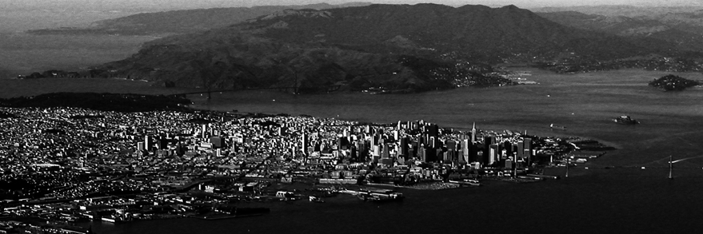
When geographers descend on San Francisco next year for the annual American Association for Geography meeting, most will undoubtedly stroll past one of the Powell Street parklets, located near the downtown conference hotels. Designed by landscape architect Walter Hood, with funding from Audi, the parklets are celebrated by Dwell magazine for beautifying one of the city’s most trod upon blocks with “torqued aluminum railing, drought-tolerant plants, and enough space for pedestrian-choked Powell Street to breathe” (Britt 2011). One of Dwell’s favorite aspects of the parks’ design is how they narrow the cable-car lined Powell Street to two lanes, effectively prohibiting automobile traffic. The Powell Street parklets are hardly an unusual sight in bike-friendly San Francisco – the city’s Pavement to Parks program has supported sixty similar sidewalk spaces (See San Francisco’s Pavement to Parks Program for a map of the city’s parklets). While most parklets don’t take over car lanes, they do occupy parking spaces, and most include bike racks – encouraging this “greener” mode of travel. As popular, year-round destinations, many parklets are sponsored by neighborhood businesses, as they facilitate other kinds of green circulation and consumption.

Are the parklets an example of sustainable urbanism? They are according to the city-planning department, which describes its Sustainable Development Program as exploring “new options for growth that protects the environment while laying a foundation for prosperity.” Here planners may be taking a page from San Francisco’s Rebar design collective, which is credited with inventing the concept in November 2005, when they fed a parking meter on Mission Street for two hours, rolled out sod, set up benches, and demonstrated how easily urban “niche spaces” could be “revalued” as public parks. Rebar dubbed this DIY intervention “tactical urbanism,” and spread the brand through a free online manifesto, manual, posters, and $20 t-shirts. Ten months later, the first “Park(ing) Day” was held in 13 other cities, spawning a tradition that continues today on the third week of September in hundreds of cities around the world, and that many credit with democratizing sustainable urbanism, albeit on a temporary, small scale. (On the global spread of San Francisco’s parklets, see King 2015)

Yet opinion on the parklets’ sustainable credentials is by no means unanimous, and nowhere less so than in their hometown. San Francisco “complete streets” advocates, for example, noting that sponsoring businesses are responsible for parklet design and maintenance, critique them for privatizing public space, and providing unfair advantage to those with the social capital and entrepreneurial ability to propose and manage them (Morhayim 2014). Chinese American businesses on San Francisco’s Clement Street see the conversion of scarce parking spaces into “outdoor café-style seating” as a threat to their economic survival, as well as a “harbinger of the city’s laid-back youth culture” replacing the street-life of an ethnic enclave (Lee 2014).

Then consider the city’s inability to hire enough public school teachers for the 2015-2016 school year, due in large part to an extremely high cost of living in San Francisco. How is this related to parklets, we might ask? The city’s teacher gap is indicative of its declining middle and working-class residential populations overall, as the city becomes a bedroom community of Silicon Valley, begging the question of exactly who is able to enjoy its new parks program. Further, there is the question of whether this form of urban greening is actually contributing to the problem of unaffordability by driving up local rents. Zephyr Real Estates’ 2015 calendar, featuring a different parklet for every month alongside “the renowned properties sold by Zephyr” nearby, would seem to support this concern.

Thus a growing number of “right to the city” advocates argue these parklets—together with market-oriented forms of urban greening and tactical urbanism generally, are better understood as a form of “environmental gentrification.” (See e.g. Melissa Checker (2013) on environmental gentrification. For related critiques of DIY and tactical urbanism by an urban sociologist and critical geographer, see Gordon Douglass, 2014 and Brenner, 2015). Further, these local effects can be tied to a wider dynamic of uneven development, as eco-gentrification drives displacement, which pushes out low income and mostly non-white residents to sprawling, car-dependent suburbs, which expands the carbon footprint of cities and regions. (Pollack et al, ; Chapple et al. On how this is linked to uneven development see Greenberg, forthcoming).

The most oft-cited definition of “sustainable development” is helpful in thinking through this parklet conundrum. As conceptualized by the 1987 Bruntland Report, Our Common Future, sustainable development seeks a balance between the 3 E’s of equity, ecology, and economy. According to this framework, San Francisco’s parks program and the planning department more generally—which does not account for the higher property values that their greening projects indirectly cause nor for the exclusion built into their decentralized management structure—can be understood as a failure of sustainable urbanism, in that it privileges the economy over both ecology and equity, to the detriment of all three.

The parklets example and the questions it raises showcase some of the deep ambiguities of the discourse and practices of “sustainability,” which is arguably one of the most influential keywords of our time. In September 2015, as San Francisco deals with its teacher crisis, the UN will adopt its Sustainable Development Goals, replacing the Millennium Development Goals (MDGs), which were established in 2000 and had targeted global poverty. Through the SDGs the UN refocuses on the concept it popularized in 1987, yet in a moment in which “sustainability” has become a household term – guiding public policies, consumption habits, and social movements. The parklets example also raises the question of how to think about and evaluate the myriad sustainability projects that are a consequential part of everyday life. What kinds of environments—ecological, economic, social—do they seek to sustain? What unintended consequences may they entail? Who gets to design them, and to evaluate their impacts?

For the past three years, a research group based at the University of California Santa Cruz has developed a “critical sustainabilities” [CS] framework as a way of analyzing the competition between different sustainability discourses and practices. A core premise of the group is that there is not one monolithic version of “sustainability,” but rather that we are living in a time in which multiple sustainabilities circulate – some more powerfully than others, and often with contradictory effects. These issues, we think, are not purely ‘academic,’ nor are they straightforward. While some argue that “sustainability” is simply neoliberal capitalism in disguise—and while prevalent forms of sustainability conceived of and managed by the private sector are indeed shaped by neoliberal logics— the CS framework attends to multiple approaches, exploring their distinctive epistemologies, ideals, and potentialities. For example, we contrast and look for linkages between “market-oriented sustainability” and alternative approaches that are primarily vernacular, ecologically-oriented, and/or justice-oriented (Greenberg 2013). In this way we hope to examine when and under what circumstances a balance between the “3 E’s” may be achieved, or when it might not.

We created a website —https://critical-sustainabilities.ucsc.edu—through which to trace the roots of the multiple sustainabilities circulating in our region today, as well as to explore the lively and productive debates arising over how we use the term—in the Bay Area and beyond. The website, still in its early stages, features site-specific projects —clustered around San Francisco, Oakland, and Berkeley, but throughout California as well —that are linked and locatable via an interactive map, as well as connected to a list of “keywords” that explore underlying concepts. Through visiting multiple keywords and sites on the map—virtually and on foot—you can learn from local researchers about how distinct approaches to sustainability have been produced, as well as where and how conflicts over rival approaches have played out.

We believe that the sustainable urban imaginary of the San Francisco Bay Area provides an invaluable laboratory for research—and for conference attendees interested in exploring these issues beyond the parklets on Powell Street. As explored on the site, the region has long figured as “Ecotopia” in the popular imagination —from its starring role in the eponymus cult novel, now in its 40th anniversary printing (Callenbach 2015); innumerable science fiction films, both utopian and dystopian (Miller 2013); and eco-oriented media and cultural movements that captured the zeitgeist, from the Whole Earth Catalogue to Dwell (Kirk 2007; Sadler, 2015). Underlying and feeding these representations, the Bay region has been a standard-bearer for California’s famously progressive environmental policies, planning efforts, and political movements (Walker, 2009). Influences can be traced to Oakland’s long history of environmental and food justice organizing, from the Black Panther free food program to the Mandela Marketplace; Berkeley’s embrace of “counterculture green” and “hippie holism,” from the Integral Urban House to the North Berkeley Farmers Market; and now Silicon Valley’s merger of eco-radicalism and tech-futurism, as seen at Googleplex in Mountain View and soon to open Apple 2 in Cupertino, celebrated as the greenest buildings on the planet (On history behind Silicon Valley’s pastoral tech campuses see Mozingo, 2011).


And now we find the region at the cutting edge once again, this time however for controversy over what activists, planners, and many geographers argue is the inequity and negative environmental impacts of dominant models of sustainability policy and planning. As contributors to our site explore, this includes the question of the agro-ecology and labor practices of “organic” and “locavore” cuisine (Guthman 2003, 2004); the debate surrounding “Google buses” and their impacts on public transit and rents (Brahinsky 2014, Henderson, 2013); as well as the potential for urban greening projects of all kinds, when disconnected from affordable housing, to exacerbate gentrification, displacement, and sprawl—as seen at the Cesar Chavez Greenway16th and Mission BART Plaza, and Bayview Hunters Point Redevelopment. (Chapple et al. 2007; Great Communities Collaborative, 2007; Dillon 2014).

    Share