The Coming ‘Dry-Wet Knockout’ in California
Seven of the last 10 years have been dry in California, and the last four have been critically dry. The drought is a top concern for Californians, with two-thirds of the state in extreme to exceptional drought. Severe droughts are one feature of our state’s climate; extremely wet years are another. In fact, droughts and floods are two sides of the same coin, because often extremely wet winters have followed on the heels of severe and prolonged droughts. This coming winter, a major El Niño is predicted, and may bring heavy rains accompanied by flooding, mudslides, and landslides.
The coupling of prolonged droughts with extreme wet years has been dubbed a “dry-wet knockout” by climate scientists, who have found that these occur with unnerving frequency in California’s climate history. In just the past century we have seen several examples. The years between 1928 and 1937 were among the driest of the 20th century in California, desiccating the grasslands of the Central Valley and the slopes of the mountains, and shrinking rivers and lakes. Then the winter of 1937-38 saw a series of storms deluge the northern two-thirds of the state, including two storms that dumped 10 inches of rain in southern California, flooding areas from San Diego to Los Angeles and into the Mojave Desert.
This dry-wet scenario was repeated two decades later a drought in the early 1950s was followed by massive floods in 1955, particularly throughout the central Sierra Nevada and the San Francisco Bay region. In Orange County, warm rains melted snow in the San Bernardino Mountains, causing catastrophic flooding of the Santa Ana River. Two decades later, the climate coin flipped from the driest year on record, 1976-1977, to the torrential rains of 1977-1978. More recently, the prolonged drought of 1987-1992 was followed by the extremely wet winter of 1993.
These scenarios are particularly stressful on local and regional ecosystems. They have been called “dry-wet knockouts” because drought weakens ecosystems, and the following floods deliver a “knockout” blow. Vegetation that holds the soil in place withers during droughts, and the soils desiccate and are more easily eroded. Forests become dangerously dry and susceptible to wildfires sparked by summer lightning strikes. Then the knockout: a winter with storm after storm spawned out over the Pacific slams into the west coast. Heavy rains easily erode the fire-charred slopes, washing massive amounts of sediment downhill, eventually choking streams and lakes. The sediments raise the bed-level of rivers, exacerbating floods. Once on the move, the slurry of sediment-laden waters disrupts downstream aquatic ecosystems in ponds, lakes, estuaries, and even the coastal ocean. Dry-wet knockouts become natural disasters for Californians, as economic losses due to drought are compounded by the subsequent devastation of deluges. Homes – sometimes entire neighborhoods – can be buried in massive mudslides; roads and highways buckle as the once-solid earth is eroded out from beneath them; agricultural fields are inundated and crops lost. The floodwaters can take months to finally drain.
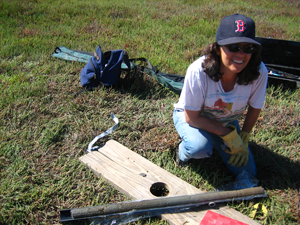
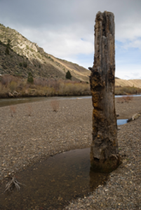
What do the paleoclimate records tell us about these dry-wet knockouts? For one thing, they were not a unique phenomenon of the 20th century. Prolonged droughts are common, occurring once or twice per century. And every one to two millennia in California, climate shifts to a dry phase, or megadrought, lasting a century or longer. For instance, during the Medieval Warm Period, from 900 to 1350 A.D., precipitation in the region dropped to 60 percent of average and wildfires were 30 percent more frequent. Two distinct megadroughts occurred during the Medieval Warm Period, each lasting over 150 years, and each dramatically ending in megafloods. The megadroughts brought down flourishing civilizations, with archaeological evidence of malnutrition, infant mortality, violence, and warfare. Evidence of subsequent widespread knock-out megafloods is clear. For instance, tree stumps found in the middle of lakes in the southern and eastern Sierra Nevada are what remain of trees that grew for over a century during the prolonged medieval droughts and were suddenly drowned by heavy rains and huge floods. Hundreds of miles away, sediment cores collected from beneath the San Francisco Bay and its tidal marshes reveal evidence of megafloods immediately following the medieval droughts. Perhaps the largest knock-out megaflood occurred in AD 1605, after another decades-long drought. Floodwaters rushing through the Bay scoured the estuary and at the same time the sediment-rich floodwaters deposited thick layers of mud on the surrounding marshes.
The dry-wet knockouts seen in the paleoclimate record are of a much greater magnitude than what our 20th century experiences have been. The more comparable event in historic memory would be the deep drought of the mid-19th century, which peaked in 1860 and was followed by a series of large storms that flowed, one after another, across the Pacific during the winter of 1861-62. Recent research reveals that these were atmospheric river storms – narrow corridors of water vapor that originate over the tropical Pacific Ocean and travel thousands of kilometers to the West Coast, carrying up to 10 Mississippi Rivers worth of water. The Central Valley – 400 miles long and 50 miles wide – was turned into an inland sea in 1862, and Sacramento was submerged for months. Water planners considered the 1861-62 Flood a 1,000-year event, but the paleoclimate records suggest that floods of this magnitude recur every 100-200 years.
Today, many regions in California are even more vulnerable to flooding than during 1861-62. Viewed from above, the Central Valley looks like a giant bathtub, four hundred miles long and seventy miles wide, with San Francisco Bay Delta Estuary as the drain. The region’s population has swollen from 500,000 in 1861 to almost 39 million today, while in the Central Valley, housing developments are replacing agricultural lands in the floodplains. This growth has led to soil compaction, loss of wetlands, and subsidence, causing much of this vast region to literally sink – by as much as thirty feet in some areas. Today, the region is far more susceptible to flooding than it was during the 1861-62 floods. Floodwaters filling the Central Valley now would submerge major population centers instead of small towns, marshes and farmlands. Densely populated cities like Modesto, Fresno, Stockton, and Sacramento are protected by a relatively primitive network of fragile levees that serve as the only line of defense against floods on the Sacramento and San Joaquin rivers.
A warmer world will bring a drier climate to California – an inevitable consequence of higher evaporation rates and shifting storm tracks. But the underlying climate patterns producing dry-wet knockouts will not go away. In fact, it is likely that they will be exacerbated as more precipitation falls as rain than snow during the warmer winters, causing larger floods. At the same time, more evaporation over the tropical Pacific Ocean will spawn larger atmospheric river storms – the type of storms that bring the most flood-producing deluges to California. California needs to begin serious preparations now for both extremes: water scarcity, and larger floods, in the future.
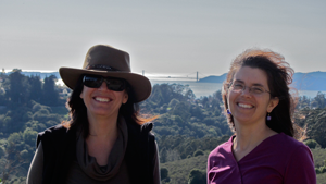
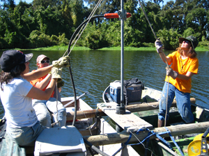
Professor Lynn Ingram studies the history of climate change in California using sediment cores from lakes and estuaries, including San Francisco Bay. Dr. Ingram is a Fellow of the California Academy of Science, and is a Senior Fulbright recipient. She has been a Professor in the Departments of Earth and Planetary Science and Geography at UC Berkeley since 1995. She is the author of more than 60 published scientific articles on past climate change in California and the West.
Dr. Frances Malamud-Roam is a Senior Environmental Planner and Biologist at Caltrans. She received her B.A., M.A. and Ph.D in the Department of Geography at UC Berkeley, with research expertise in the origin of agriculture in China, the long-term evolution of salt marshes and estuaries along the Pacific Coast, and changing climate in California and the West. She has taught earth science and physical geography at Sonoma State University and Laney College.
Both are authors of a new book on the climate history and water resources in California (UC Press, 2013): The West without Water: What Past Floods, Droughts, and Other Climatic Clues Tell Us About Tomorrow.