Julian Wolpert was born on December 26, 1932, to Rose and Harry (Hillel) in Brooklyn, New York. After attending Yeshiva for elementary school, Julian attended Erasmus Hall High School, where he met his future wife Eileen Selig, and graduated at the age of 16 in 1949.
Upon graduation, he enrolled at City College in New York and later transferred to Columbia University, where he received a degree in Economics in 1953. He and Eileen married in 1955, and the following year he entered Officer Training School for the U.S. Navy, as a Navigator at the rank of Lieutenant Junior Grade.
Upon separating from the Navy in 1959, Julian entered the graduate program in Geography at the University of Wisconsin in Madison, completing his Ph.D. in 1963. He then joined the faculty at Michigan State University, transferring to the University of Pennsylvania in 1965. There, he rose to the rank of full professor. In 1973, he spent a sabbatical year at the Center for Advanced Studies in the Behavioral Sciences in Palo Alto, California. The following year, he became the Bryant Professor of Geography, Public Affairs, and Urban Planning in an endowed chair at Princeton University’s School of Architecture and Urban Planning, and later was a Guggenheim Fellow at Princeton’s Woodrow Wilson School of Public and International Affairs. He retired in 2005 and remained Professor Emeritus.
Over his career studying location theory, the provision of public and nonprofit services, urban development, and environmental policy, he received numerous distinctions. He was the first Geographer elected to the National Academy of Sciences (1977), became a Fellow of the Center for Advanced Study in the Behavioral Sciences, a Guggenheim Fellow, a Russell Sage Fellow, and a member of the American Association for the Advancement of Science. He was also past Vice President and President of the Association of American Geographers, Vice President of the Regional Science Association, and was elected to the American Institute of Certified Planners. He testified before Congress and worked with various federal agencies, including the National Science Foundation, the U.S. State Department, and the National Institute of Mental Health.
He is the author of more than 100 highly significant books, journal articles, and reports. He was a pioneer in the use of computers and multivariate analysis of large data sets.
“His research and teaching always revolved around the underserved and the mobilization of resources and policies to better serve them,” recalled colleague John Seley, professor emeritus, of Earth and Environmental Sciences, Psychology, at CUNY Graduate Center.
Julian Wolpert is survived by a sister, Judith, children Seth, Jesse, Joshua, and Rebekah, and grandchildren Geoffrey, David, Jake, Samuel, Benjamin, Isabel, Lily, and Ida.
Navigating Human Dynamics—Reflections on Chairing the AAG Symposium on Environmental Exposure, Mobility, and Health
By Michaelmary Chukwu
At the 2025 AAG Annual Meeting in Detroit, I had the incredible opportunity of serving as both a session chair and presenter for the 11th Symposium on Human Dynamics Research. This year’s symposium, themed “Human Dynamics and GeoAI,” marked a major evolution of geographic thought—building on a decade of intellectual contributions that have redefined how we understand human-environment interactions in increasingly multifaceted physical and virtual worlds. Thanks to Dr Xinyue Ye, Department of Landscape Architecture and Urban Planning, Texas A&M University and Dr Xiao Huang, Department of Environmental Sciences, Emory University, for allowing me to take up such a monumental adventure—one that has shaped my experience of AAG for the better.
The symposium’s foundation was engrained in a timely recognition: that contemporary human experiences of space and place are no longer limited to traditional geographies with which we already are familiar. Rather, spatial experiences now unravel across hybrid realms shaped by technologies such as the metaverse and fediverse, generative AI, and quantum computing—although these are relatively novel to me. As spatial researchers, we are often challenged—and empowered—to adapt our conceptual and analytical designs to this convergence. The sessions I chaired brought together a diverse group of scholars exploring how dynamic environmental exposures, shifting mobility patterns, and evolving health outcomes intersect in this digitally augmented landscape. Collectively, these sessions illuminated the role of GeoAI as both a lens and a tool for addressing these multifaceted challenges. My aim in this article is to reflect on my experience facilitating and participating in these sessions, highlighting key themes, emerging insights, and the broader significance of human-centered, technologically informed geography in an era of rapid transformation.
A Broad Shift in the Discipline
The field of human dynamics has always been centered on the spatial understanding of how people interact with their environments—how they move, where they are exposed to risks, and how these patterns shape health, opportunity, and resilience. Nevertheless, in today’s ever-changing world, these interactions have become more fluid, complex, and pushed by emerging technologies. I like how Dr Ye articulated this perspective:
The foundation of human dynamics research lies in understanding human needs, wants, and constraints… GeoAI, with its ability to analyze spatial data through artificial intelligence, will play a critical role in bridging human dynamics with geographic insights, offering new ways to understand and respond to complex urban challenges.
The 2025 Human Dynamics Symposium embraced this evolution, emphasizing a human-centered and convergence-driven approach to research. As we step even deeper into a hybrid era where physical places and virtual spaces blend, our analytical frameworks must be equally adaptable and dynamic.
The sessions I chaired revealed just how far human dynamics researchers have moved beyond merely mapping mobility flows or modeling progressive exposure. They are also now interrogating how AI-generated environments, real-time data streams, and machine learning (ML) algorithms shape human behavior and social vulnerability. A clear example is that the integration of data with environmental risk models can enable a sharper understanding of who is exposed to what hazards—and why. Similarly, GeoAI (the intersection of GIScience and AI) allows us to uncover disparities in exposure, which traditional lone geospatial techniques could not dictate. As Dr Huang has written, “As AI technology keeps evolving, we want to keep pace using it for socially beneficial purposes.”
This burgeoning intersection between technological innovation and geographic inquiry reflects a broader shift in the discipline. No longer are we just observers of mobility—we are now very much inclined to predicting, intervening, and (re)co-constructing human-environment futures. As many of the scholars presented their studies on everything from post-pandemic mobility changes to ethical concerns in AI-based exposure assessments, a clear theme emerged: human dynamics research must not only respond to technological disruption but also lead the way in shaping its implications for equity, access, and sustainability.
The author presenting at the AAG symposium he also chaired. Credit: Daniel Kissi-Somuah
The first session focused on urban mobility and exposure disparities, setting a strong foundation for critical thinking and reflection on spatial inequities. Papers examined e-scooter adoption in Charlotte, flow detection techniques for board-scale mobility data, and state policy implications for climate and worker health in Canada. Particularly notable was a paper proposing the use of Points of Interest (POIs) as sentinel nodes for infectious disease surveillance, offering a compelling intersection of geospatial methods and public health. All presenters made important submissions that sparked deep philosophical thoughts in geography.
The second session featured methodological innovations among geographically diverse studies, such as shared-bike mobility dynamics in Seoul, modeled carbon efficiency using urban scaling laws, and the linkages of urban sprawl with subjective well-being in the U.S. One presentation stood out for its novel use of geolocation data to examine tobacco exposure risks using a neuroscience framework. Another presented COVID-19 risk mapping in Kwara State, Nigeria, broadening the discussion to global health geographies and data-sparse regions. This session embodied the kind of interdisciplinary and cross-regional inquiry that the symposium aims to foster.
The final session turned attention to post-pandemic urban restructuring and digital-physical convergence. Presenters addressed the “donut effect” in U.S. cities due to remote work, correction methods for pedestrian mobility biases in Strava data, and the use of graph neural networks to estimate population flows from multimodal transport data. Two of the last presentations caught my attention: an analysis of mobility equity in four Atlanta neighborhoods in the context of the 15-minute city framework, and a forward-looking piece on GIS-based hybrid space-place approaches, emphasizing the need to rethink individual behavior across physical-virtual boundaries.
Throughout the day, the diversity of topics—ranging from graph theory and machine learning to behavioral geography and environmental justice—underscored the multidimensional nature of human dynamics research today. As an early-career geographer, I was honored to chair such a wide range of talks, with the opportunity not just to moderate, but to facilitate bridges between these ideas: connecting themes, fostering open discussion, and encouraging reflection on both technological promise and ethical responsibility.
AAG is not just a venue for presenting research, it is a dynamic community of thinkers, mentors, and co-creators of knowledge.
Presentation Insights: Sharing My Research
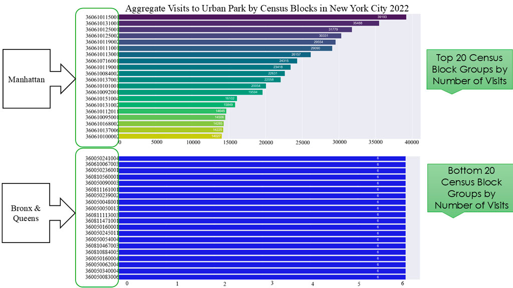
Among the highlights of the symposium was the opportunity to present my own research. I presented my study of how park visitation behavior varies across space, creating patterns that uncover inequities rooted in race, income, and location geography. Making use of longitudinal human mobility data from SafeGraph, the research revealed widening disparities in both access and usage of urban parks. More specifically, we showed that the borough of Manhattan enjoyed more access and use of parks—a predominately white area, compared with The Bronx, Queens, and Brooklyn, which are predominantly areas with people of color.
The author found that Manhattan enjoys far more access and use of its parks than other boroughs. Credit: Michaelmary Chukwu
My presentation illustrated persistent gaps in visitation trends, spatially and statistically, at the census block group level. Low-income and racially marginalized neighborhoods in New York City consistently lagged in park usage, despite proximity. Some parks in those block groups were not well-maintained and lacked or had uneven distribution of park amenities. This points to a deeper narrative: access is not solely about distance but shaped by systemic barriers—ranging from safety concerns to cultural disconnection.
As a first-time participant at the AAG Annual Meeting—and at the time, a master’s student at the University of Arkansas—chairing not one, but three sessions within the Human Dynamics Symposium was an experience that exceeded my every expectation. Entering such an intellectually charged and collaborative space, I initially wondered how I would measure up. But from the very first session, it became clear that AAG is not just a venue for presenting research, it is a dynamic community of thinkers, mentors, and co-creators of knowledge.
The privilege to engage with and learn directly from leading scholars in the field of human dynamics profoundly shaped my understanding of the many aspects of geographical thoughts and the future. I paid close attention to how leading researchers grounded their advanced methodologies in real-world challenges such as health disparities, urban inequity, and the need for technological foresight. I appreciated how questions were asked not simply to critique, but to expand, refine, and deepen shared understanding of science of geography. This experience will remain a defining moment in my academic journey, affirming that even as an emerging scholar, there is space to lead, learn, and belong in the evolving story of human dynamics.
Michaelmary Chukwu is a Ph.D. student in Geographical Sciences and Cartography at the University of Maryland. He completed a master’s degree in Geography from the University of Arkansas in 2025 and a bachelor’s degree in Urban and Regional Planning from the University of Ilorin, Nigeria in 2021. He is a student member of the American Association of Geographers (AAG), American Planning Association (APA), and Cartography and Geographic Information Society (CaGIS) while also being a distinguished full member of Sigma Xi and Phi Kappa Phi Honor Societies. Michaelmary’s research interests are in GIScience, urban mobility, spatial statistics, GeoAI, computational social science, urban studies, active transportation, and remote sensing. He has received recognition for his outstanding works including a national scholar award from the University of Arkansas and Third Place student poster at the Southwest Regional Division of AAG.
Perspectives is a column intended to give AAG members an opportunity to share ideas relevant to the practice of geography. If you have an idea for a Perspective, see our guidelines for more information.
Share
On the Map
The Hills of San Francisco
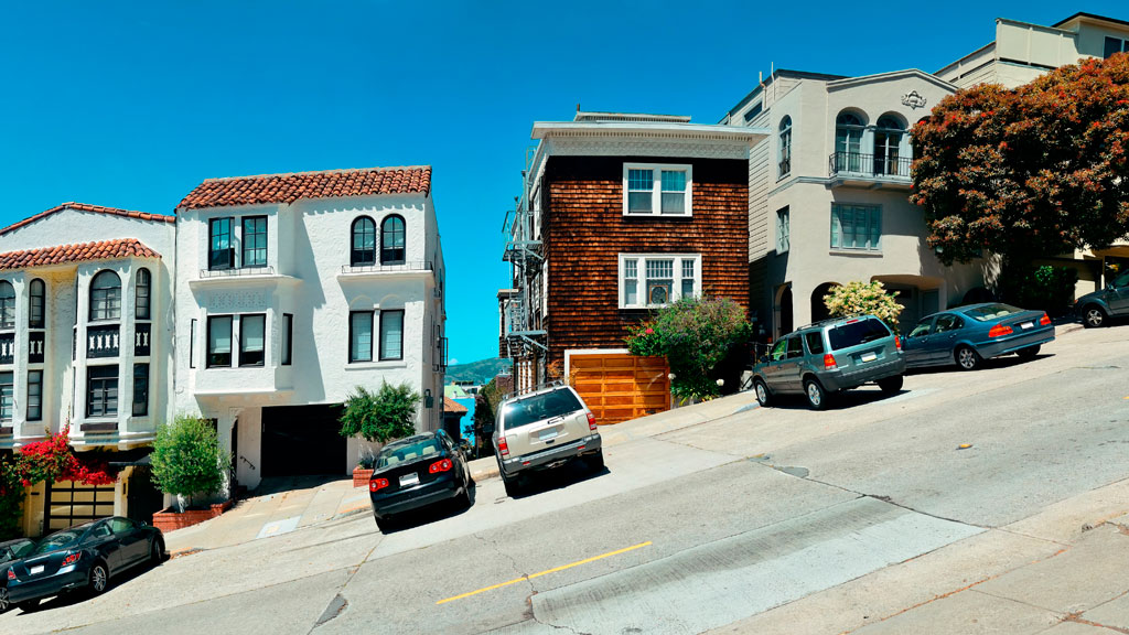
Street hill gradient in San Francisco
Unlike the rest of California, San Francisco has a unique geography that shapes its weather and settlement patterns. The city is set on the tip of a peninsula halfway up the coast of northern California, surrounded by bodies of water on three of its sides: the Pacific Ocean, the Golden Gate strait, and the San Francisco Bay. The city is laid out over hills that stretch from coast to coast, reaching heights of nearly 1,000 feet, making the climate similar to coastal areas on the Mediterranean.
The hills of San Francisco define its topography and culture. It’s hard to pinpoint the exact number in the city, but many sources consider there to be more than 50 named hills. As Pulitzer Prize-winning San Francisco Chronicle columnist Herb Caen notes in his introduction to the Hills of San Francisco, no one can quite agree on which [hills]. Although it’s debated among locals, there are seven hills that are iconic to the city: Russian Hill, Nob Hill, Telegraph Hill, Twin Peaks, Mount Davidson, Mount Sutro, and Rincon Hill.
So, when is a hill a hill? Self-proclaimed San Francisco explorer Dave Schweisguth claims, “When it’s a lone mountain. That is, if you can walk all the way around it, always looking up to its summit. It’s not so clear cut when hills run together into a ridge, which most of San Francisco’s do. Height alone is not so important: a very small hill may be perfectly obvious, while a string of higher summits may be hard to tell one from the next. It’s easier to call a hill a hill if it’s separated from its neighbors — if, on a topographic map, a contour line or two traces all the way around its summit.”
The Range of Iconography
Originally named Blue Mountain for the wildflowers that cover the hillside, the city’s tallest hill was renamed Mt. Davidson at the urging of the Sierra Club in 1911, after George Davidson, the geographer who surveyed it. It is the focal point of San Francisco’s Mt. Davidson Park, with a forest that accounts for more than 30 of the park’s acres, quietly remaining an oasis in the most densely settled city in California. Defined by a 100-foot cross at its peak, Mount Davidson stands at an elevation of 928 feet. Urban hikers share that despite how small the overall area is, the trails aren’t consistently marked, which causes explorers to get lost in the woods.
Hikers also recommend Mount Sutro, located in central San Francisco, for its role in the city’s cultural and natural history. Its century-old trails are now preserved by the University of California, San Francisco, which guides the long-term restoration of the 61 acres and protects the ecological oasis in the heart of the urban environment, along with the citizen group Sutro Stewards. The city’s elevation and abundant summer fog contribute to the mountain’s microclimates and its plant and wildlife communities.
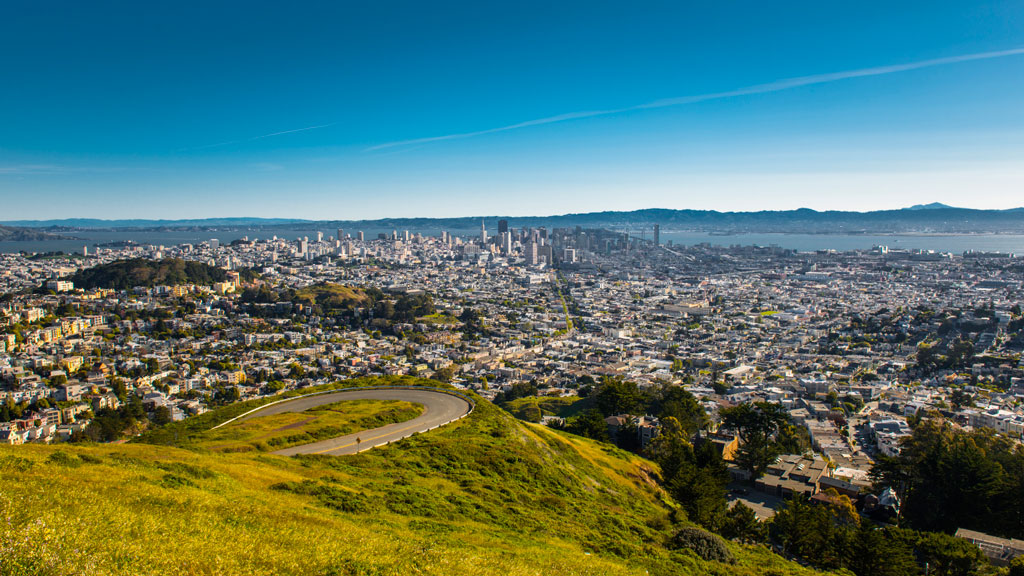
Twin Peaks view in San Francisco. Credit: optionm, Getty Images
Originally called “Los Pechos de la Choca” (Breasts of the Maiden) by early Spanish settlers, Twin Peaks is a main landmark of San Francisco’s skyline, reaching elevations of 910 and 922 feet. Similar to Mt. Davidson and Mt. Sutro, Twin Peaks hosts a 64-acre park of coastal scrub and grassland communities that offer an idea of how San Francisco’s hills and peaks looked before development changed them forever.
Early in defining San Francisco’s history, Nob Hill, Russian Hill and Telegraph Hill continue to remain among the most popular neighborhoods to visit.
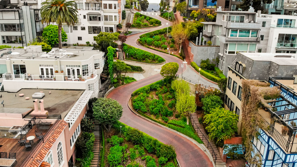
Lombard street in San Francisco Lockdown. Credit: Tiago Ignowski, Getty Images
Russian Hill’s name dates to 1847 when Russian sailors were buried on the hill during the gold rush in the 1800s. The burial sites are long since deeply covered, and it’s now only possible to admire a plaque at the site where the cemetery once stood. This is the same neighborhood home to the famous Lombard Street, that draws tourists from around the world due to its scenic switchbacks and postcard views. Because the slope in this area reaches 27° (51%), 8 hairpin bends were put in the 1300 feet between Hyde Street and Leavenworth Street to allow cars to drive down the street, ultimately creating one of the most winding streets in the world.
Russian Hill borders Nob Hill to the south, one of the city’s most upscale neighborhoods. Originally called California Hill (after California Avenue, which runs right over it), Nob Hill got its name from the word “nabob” that originated from the Hindu word meaning a wealthy or powerful person. This affluent neighborhood was home to the Central Pacific Railroad tycoons known as the “Big Four,” who were among the first to build their mansions here.
View up to Telegraph Hill’s Coit Tower. Credit: slobo, Getty Images Signature
Telegraph Hill hosts Coit Tower, an iconic piece of architecture that resembles a fire hose and affords incredible views of the city; its walls are also home to historic artwork. Originally, the Tower was a windmill-like structure created in 1849 to signal ships entering the Golden Gate. Once the trek is completed, the summit provides a breathtaking panoramic view of the city with landmarks like the Golden Gate Bridge, Alcatraz, and the Transamerica Pyramid.
Whether you’re taking a leisurely stroll or hiking the steepest routes, you can recall the words of the iconic San Francisco journalist Herb Caen, who once said, “Take anything from us — our cable cars, our bridges, even our Bay — but leave us our hills.”
You can hit the trails with a guided tour or explore the city on your own. The SF Gatecompiled a list of 11 hikes within the city limits that allow visitors and residents to get to know the landscape. An interactive map created by a UC Berkeley graduate student studying urban planning maps SF’s slopes and uses simple color coding to show where the flattest pockets of land are. If you’ll be attending AAG’s 2026 Annual Meeting in San Francisco, you’ll want to bring your walking shoes!
Share
News
AAG Welcomes Summer 2025 Interns
Two new interns have joined the AAG staff this summer. The AAG would like to welcome Cadence Bowen and Wyatt Gaines to the organization.
Cadence Bowen is a senior at Kent State University majoring in Geography with a minor in Geographic Information Science (GIS). Originally from rural Arkansas, her move to the densely populated Northeast Ohio region led to her fascination with the distinction between rural and urban geographies. Her interests include tourism in rural fishing communities, Native American and Alaskan Native geography, regional disparities in early geographic education, environmental gentrification, and urban mapping techniques using open-source GIS. Her goal as a geographer is to advocate for the importance of geographic literacy through forms of digital media sharing. Outside of her academic goals, Cadence enjoys spending her summers traveling and taking on seasonal positions. Last summer, she spent her time working in the service industry in Seward, Alaska, learning more about how tourism affects economies that rely heavily on commercial and sport fishing and local indigenous communities, specifically the Qutekcak Native Tribe. She is super excited to take on the role of being AAG’s Media and Science Communications intern this summer and expand her knowledge of geographic research and media.
Wyatt Gaines graduated summa cum laude from West Virginia University in May 2025 with a major in International Studies and minors in Geographic Information Science and Conservation Ecology. His interdisciplinary academic background informs his interest in applying geographic research to real-world challenges—a passion he brings to his work with the AAG and its diverse initiatives. Outside of academics, Wyatt enjoys weightlifting, studying languages, and watching movies. Since graduating, he has moved to Japan to work part-time as an American Youth Ambassador at the American Pavilion at the 2025 Osaka World Expo. He is honored to serve as one of AAG’s Community Support interns for the summer term. After his time with AAG, Wyatt plans to continue working in the NGO and nonprofit sectors and pursue graduate study.
If you or someone you know is interested in applying for an internship at the AAG, the AAG seeks interns on a year-round basis. More information on internships at the AAG is also available on the About Us section of the AAG website.
International Geographic Information Fund (IGIF) Scholarship
Deadline: October 15, 2026 (by midnight, Eastern)
The International Geographic Information Fund (IGIF) is an endowed fund established through generous gifts from Laura and Jack Dangermond and the Environmental Systems Research Institute (Esri). Its purpose is to support scholarships that advance student career development in the academic areas of applied spatial analysis and geographic information science/systems (SA/GISS).
The Award
These scholarships are designed for students who show clear career goals and strong potential for growth. They are especially intended for students who would significantly benefit from financial support as they work toward their professional aspirations. Scholarships are not limited to students with already well-established academic or professional records. The AAG reserves the right to determine whether scholarships will be awarded in a given year.
The AAG will distribute up to thirty-four (34) scholarships of $1,200 to undergraduate and graduate students pursuing careers in SA/GISS. Funds are intended to support activities that help students take meaningful steps toward their professional goals. Scholarship funds can be used for:
Travel to national or international conferences, symposia, or professional meetings related to SA/GISS (including transportation, lodging, meals, and other travel expenses reasonably related to travel for attendance at such meetings).
Tuition, books, equipment, laboratory, or other academic fees at accredited U.S. institutions.
Scholarship funds may not duplicate support from other awards and must be used within one (1) year of acceptance. Scholarship recipients are strongly encouraged to attend the AAG Annual Meeting, where they will be invited to an Esri Young Professionals Network (YPN) reception and recognized at the AAG Awards Reception. Recipients are expected to acknowledge Esri IGIF support in any work funded by this scholarship.
Eligibility
Be a full‑time student.
Be enrolled at an accredited higher education institution within the United States of America.
Be pursuing an undergraduate or graduate degree or specialization in SA/GISS.
Not have previously received this scholarship within the same academic category (undergraduate or graduate), to help broaden opportunities and recognition for more students.
Applications
A complete application must be received no later than the close of business on the deadline (Eastern Time).Incomplete applications will not be reviewed.
1. Curriculum Vitae (maximum 2 pages).
2. Faculty Advisor Letter (maximum 1 page, on letterhead). The advisor must confirm that the applicant:
o Is a full time student in good standing.
o Is enrolled in an SA/GISS program.
o Shows strong promise in their stated career goals (and why).
3. Applicant Statement (maximum 3 pages, with up to 2 pages of optional supporting illustrations). The statement must include:
o Introduction and Professional Interests – Briefly describe your academic background and current interests in SA/GISS.
o Career Goals – Outline your short and long term career goals and explain how your academic work supports them.
o Proposed Use of Scholarship Funds – Clearly describe the activities or expenses you are requesting support for and explain their relevance to your career development.
o Justification and Financial Need – Explain why this scholarship is essential for enabling the proposed activities, including financial constraints and why these costs cannot be supported through other funding sources.
Criteria
Applications are evaluated on the clarity and strength of the written materials, alignment of career goals with SA/GISS, proposed use of funds, and demonstrated financial need. Undergraduate and graduate applicants are evaluated within their academic level.
Faculty advisor’s letter – 10%
Clarity, organization, and quality of written statement – 25%
Clarity and alignment of career goals within SA/GISS – 25%
Proposed use of funds and connection to career development – 25%
Justification and financial need – 15%
Each year, AAG staff convene an IGIF Esri Scholarship Committee to review applications and select recipients. The committee includes board members from AAG Communities specializing in SA/GISS, such as the Spatial Analysis and Modeling Specialty Group (SAM) and the Geographic Information Science and Systems Specialty Group (GISS‑SG), or other SA/GISS leaders within the AAG Community.
Final selections are made at least 45 days before the AAG Annual Meeting, and applicants are notified shortly thereafter. In its review, the committee aims to:
Prioritize applicants whose career development would be meaningfully advanced by this scholarship, particularly those with clear goals, strong potential, and limited access to other funding sources.
Recognize the most deserving students.
Find an appropriate balance of undergraduate and graduate awardees based on the applicant pool, though the number of awards in each category may vary from year to year.
The following statements and actions represent AAG’s work to protect and strengthen geography and geographers, address pressing public issues, and to protect science funding and academic freedom. For a comprehensive look at AAG’s positions over the years, check out our advocacy in the Resource Hub.
Academic Freedom and Commitment to Geography’s Future
Letter to Indiana Governor Eric Holcombe, urging him to veto SB 202, which restricts academic freedom and subjects faculty to new scrutiny over tenure, March 2024
Protecting science funding: AAG contacted members to gather stories about impacts of science funding cuts. We coordinated with the American Federation of Government Employees to provide these testimonials for possible use in legal action against the Office of Personnel Management, March 2025
On January 2, 2025, Dr. Brian Berry passed away at the age of 90. Renowned for his influential work in urban and regional research, he was also a past AAG president (1978-79).
Berry was born in Sedgely, Staffordshire, United Kingdom on February 16, 1934. He graduated from University College, London, with a B.Sc. in Economics with first class honors in 1955. He was a Fulbright scholar at the University of Washington, where he completed an M.A. in 1956, and a Ph.D. in 1958, studying under noted geographer and leader of the quantitative revolution, William Garrison, in the Department of Geography.
Upon completing his Ph.D., he began his career, which spanned more than six decades. In 1958 he was named the Irving B. Harris Professor of Urban Geography, chairman of geography and director of the Center for Urban Studies at the University of Chicago. Berry’s early spatial analytic research helped spark the scientific revolution that occurred in geography and urban studies in the 1960s, making him the world’s most frequently cited geographer for more than 25 years. He refined the concept of “central place theory” and laid the foundations of analytic urban geography, spatial analysis, and of geographic information science.
In 1975, Berry was the youngest social scientist ever elected to the National Academy of Sciences. He subsequently was named a Fellow of the American Academy of Arts and Sciences and of the British Academy. From 1976 to 1981, Berry joined Harvard University where he served as the Frank Backus Williams Professor of City and Regional Planning, chair of the Ph.D. Program in Urban Planning, director of the Laboratory for Computer Graphics and Spatial Analysis, and a faculty fellow of the Institute for International Development. He was appointed University Professor of Urban Studies and Public Policy and dean of the Heinz College at Carnegie Mellon University, until he joined the University of Texas at Dallas (UTD) in 1986.
At UTD, Berry became the first director of the Bruton Center for Development Studies. In 2005, he was appointed dean of what was then the School of Social Sciences before he engineered its transformation into the School of Economic, Political and Policy Sciences (EPPS).
Among his many accolades, Berry was the 1978-79 President of the Association of American Geographers. In 1988, he was also awarded the Victoria Meda, the Royal Geographical Society’s highest honor, and the Vautrin Lud Prize — considered the “Nobel Prize for Geography” — in 2005. He also earned the Kondratieff Medal from the Russian Academy of Sciences in 2017 and the Stanley Brunn Award for Creativity in Geography from the American Association of Geographers in 2020. Most recently, in 2021, Berry earned the University Consortium for Geographic Information Science Research Award. The award recognized Berry’s early research on geographic information systems — specifically his conceptualization of the geographic matrix in 1964 — that continues to shape practice and to ensure conceptual and functional linkages between geographic information science technique and the field’s intellectual core.
Although Berry authored over 550 books and articles, he is most proud of being the advisor to more than 150 Ph.D. students and has served on an equal number of other doctoral committees. Many of his students have gone on to successful academic and professional careers in their own right.
He also has been an active family historian and genealogist, with many additional publications to his name, most recently delving into genetic genealogy. Brian retired from active academic life to become a “gentleman rancher” in 2020. Brian is survived by his wife, Janet (Shapley) Berry; son, Duncan J. Berry; and daughter, Diane Berry Yakel.
Ross MacKinnon, scholar and administrative leader at UConn, SUNY-Buffalo, and the University of Toronto, passed away from pancreatic cancer at his home in Sonoma, California, surrounded by family, on Jan. 27, 2025, at the age of 82.
As a geographer, he was well-versed in the development of mathematical models for geographical systems, and he made particular contributions to geography through the application of these models to the fields of transportation and migration.
Ross grew up in New Westminster, Trail, and Kelowna, British Columbia. He earned a bachelor’s degree in geography from the University of British Columbia in 1964. He was a Woodrow Wilson Scholar, earning a Master of Science in geography from Northwestern University in 1966, and a Ph.D. in geography from Northwestern University in 1968. He was a faculty member of the University of Toronto’s geography department, where he became a Director of Graduate Studies. He joined SUNY-Buffalo in 1976 as Chair of the geography department and later became Dean of Social Sciences. He joined UConn as Dean of the College of Liberal Arts and Sciences in 1996 until he retired in 2008. He championed major investments in hiring, research, academic programing, and most importantly … people.
From Dr. Peter A. Rogerson, one of Dr. MacKinnon’s advisees at SUNY-Buffalo:
Ross MacKinnon was my Ph.D. advisor, and I’ll begin by literally “turning back the clock.” Somewhat more than midway through my dissertation defense, I made a statement to the effect that I was running out of time. Ross immediately got up, went over to the wall clock, and turned the hand back ten minutes. That is just a small story hinting at the many ways that he showed his support over the years. He was proactive when it came to students and recruitment — while I was taking a gap year after doing my M.A. with him at the University of Toronto, he wrote to me, convincing me to do my Ph.D. at Buffalo, where he was beginning to build the department in his new role as Chair. During my first AAG, he and I split the presentation of our joint paper. Aside from recalling how much my knees were shaking, I can now recall all of his colleagues he introduced me to — and although I didn’t have a clue at the time, I now recognize how this was one of the most important moments in my career. Over time I saw the time he spent with students, the care he took with them, and how important his mentorship was to their careers. A long line of his students and eventual professors went on to have very successful careers.
One of his traits that I always marveled at was his ability to “cut to the chase.” As a student this took the form of his knowing precisely what to ask a student. He knew what you didn’t know and needed to know, and he was unequaled in asking exactly the right question at the right time, to push you a little further. Later on, when I saw him in his roles as Chair and Dean, this took the form of sizing up both current and prospective faculty. He simply had an uncanny knack for seeing precisely how both personality and talent could or could not contribute to a department or program.
He saw to all aspects of a department — seeing to it that we not only had excellent personnel, but a vibrant social life with picnics, happy hours, and the like. Oh, and by the way, at one of those department picnics, while playing the outfield in the annual softball game, I tried to gun down a runner at second base. When I started my throw, I forgot that Ross was playing second base, and it was only while the ball was in mid-flight that I realized I should have made a softer throw. My last recollection was going to some emergency room or urgent care to see how his fingers were doing and thinking that this was not a good thing to do to your advisor.
Shortly before I arrived at Buffalo, budget cuts in the SUNY system led to very serious consideration of eliminating the department. It is difficult to capture here, but his efforts were absolutely crucial and pivotal in keeping the department alive.
He was also central to putting the department on the road to prominence (and in fact it would not be an exaggeration to say that he did this single-handedly). Part of this was attributable to his vision and his judge of talent and promise, and part was due to his vision of, and his work toward a successful bid to bring the National Center for Geographic Information and Analysis (NCGIA) to Buffalo.
Ross MacKinnon was a “quick study” when it came to sizing up people’s academic potential, their personalities, and their current or potential contributions to a department or program. His sharp wit and sense of humor gave him the ability to make lightning-quick comments about how someone could or could not help a program, might or might not become a star in the discipline, etc. Listening to his evaluations often left one both laughing at the humor and impressed with his assessment, as well as being in awe of how he could combine the two so quickly. All of this made him a fantastic mentor, colleague, Chair, Dean, and friend.
Ross was a proud Canadian and naturalized U.S. citizen. He loved travel, a good meal with friends, live jazz, contemporary painting, new plays, his dog, and the Buffalo Bills. He had a great sense of humor and was quick with encouragement.
He is survived by his wife, Marilyn Hoskin, and his two daughters, Pam and Caroline MacKinnon.
Attending an annual conference can be confusing and intimidating; regardless of whether you’re a first-time undergraduate attendee or a seasoned postgraduate student. At AAG, we want to do what we can to provide you with advice to cover all aspects of the Annual Meeting. Although this isn’t a comprehensive checklist, here are some tips and tricks to make the experience as seamless and enjoyable as possible.
Preparing for the Meeting
Travel, Lodging, and Packing
There are many factors to consider in deciding where to stay, including cost, proximity to the meeting venue, and desired experience (e.g. access to a kitchen, neighborhood vs. downtown, ability to share accommodations). Different kinds of lodging offer different advantages: the conference hotel, nearby hotels, or an option such as AirBnB or VRBO. However, AAG does reserve discounted rooms in a nearby conference hotel at each annual meeting. Understandably, attendees will seek the best deal for lodging. Students can pool their expenses together and stay in accommodations with each other.
Note details about the local airport or train station you’ll be arriving in, and public transportation options. AAG tries to select conference locations that are walkable, with good public transportation, and we share what we learn about local transportation options in our conference information.
If it’s your first time attending a conference, consider this packing list from Rebecca Rice, author of PhD in Clothes, who provides guidance about work-life balance, professionalism, authenticity and style on the academic career path. Make sure to pack shoes for easy walking—you’ll be doing a lot of walking even just inside the conference center. Think about the field trips and excursions you’d like to do, and pack shoes and outerwear for them.
Building your presentation
Whether you’re presenting a paper, poster, or attending a panel discussion, start building your presentation early. Ideally, working with a mentor can help you tailor your presentation to communicate the necessary findings and next steps of your work. You may also consider asking your department faculty and staff about their experiences attending past academic conferences. Seasoned attendees often have secret hacks or insight gained from first-hand experience.
If you are presenting, host a small social practice session with fellow students and faculty. This will allow you to time the presentation to keep within the allotted limit and to practice without a script. A practice session can also present opportunities for your colleagues to provide feedback or propose possible questions the audience is curious about.
It’s important to note that presenting is not required; If you’re an undergraduate, attending a conference gives you the opportunity to hear a wider variety of viewpoints, and can help in giving you a better impression of the discipline as a whole.
Review the Program
The AAG Annual Meeting program will be released about a month before the start of the conference. Take advantage of the available information to plan out your daily schedule by checking out familiar names, sessions related to your interests and research or abstracts which sound interesting to you.
To one side of the online program (the right side in 2025), you can refine your search by session type, modality, sponsor groups, or a curated track, which is a compilation of sessions put together with a common theme or goal. From special sessions and workshops to networking events, you can find every event listed in the program. Don’t forget to download the AAG Meeting app to keep up-to-date on the latest changes of events, reminders, and meeting information. Consult our tip sheet for quick set-up and user guidance or delve more deeply into the functions of the app with our user guide.
Attending the Conference
Check In
When planning your trip, typically plan to arrive at the conference the day before it starts. AAG’s on-site registration will open the afternoon before the first day of the event, so you will be able to go to the venue and check in to collect your name badge. It’s crucial to wear your badge when attending any event affiliated with the meeting. This will often be your first introduction to and from other attendees as you familiarize yourself with others.
Day-by-Day
With a day long schedule, it’s recommended to dress comfortably, bring a water bottle, and a snack. With numerous keynote speakers, workshops, and panel discussions constantly ongoing, the meeting will feel hectic and confusing. Embrace the experience! Narrow in on sessions that call out to you and take the time to gain insights from presenters in your research niche. Engage in Q&A sessions, introduce yourself to other students, and don’t be afraid to ask for advice.
Networking doesn’t come easy, but with practice, it will come naturally over time. Students may take the time to prepare business cards and a brief elevator pitch about research interests or future goals. Get in touch with university professors and other students to start building a network of acquittances. Here are annual events that offer these opportunities. The best way to find these sessions are to filter the program by “AAG Events.”
Welcome Reception—The reception takes place on the first evening of the conference with drinks, bites, and space to mingle with other attendees.
Plenaries, Award Sessions, and Panels—With more than 1,000 sessions to choose from, it’s easy to get overwhelmed. AAG has several special types of sessions you can seek out in the program, from the special events to numerous awards sessions and plenary panels hosted by AAG Specialty groups.
World Geography Bowl—An AAG tradition is the World Geography Bowl, a fun, often fast-paced competition of student teams from AAG Regional Divisions. It’s a great opportunity to cheer on your peers, learn a few new things about geography, and mingle with other students.
Careers and Professional Development Center—Each year, AAG features a large track of over 50 panels, paper sessions, workshops, and networking events focused on career preparation and professional development for geographers. These sessions and events will take place throughout the entire conference in the Careers & Professional Development Center, a central hub for students, early-career professionals, job seekers, and other attendees to network and learn from professional geographers and develop strategies for finding employment in geography-related occupations.
Student Day—In addition to specialized offerings for students throughout the entire week, AAG works with student members to organize a full day of sessions dedicated to student research, methods training workshops, career planning & mentoring, and networking events and activities for students at all levels of higher education. Keep an eye out for the curated track and create your own schedule year after year.
Specialty and Affinity Group Business Meetings—AAG’s more than 75 specialty and affinity groups all have business meetings during the annual meeting. These meetings are usually small gatherings that provide excellent opportunities for you to discover an interesting community of your own—or several. The meetings are open to all AAG 2025 participants, and in fact many specialty and affinity groups see their business meetings as an important way to engage and recruit new members.
Conquer Your Fear of Missing Out
Take a break! Explore the area! It’s likely you won’t have time to attend everything you planned, and you may even skip an event you had slotted into your schedule to keep yourself from getting worn out. Many attendees are travelling from out of town, so this is an opportunity to connect with our host city. Specialty and Affinity Groups often organize field visits that align with their core interests that venture out to local neighborhoods, historical sites, or a hands-on engagement project. During the registration process, you can choose the workshops and field trips you’d like to participate in. If you are already registered, simply click the Register Now button on our website to access your registration and add events.
The Follow Up
Reflection and Outreach
As you travel home, take a moment to collect your thoughts. Make note of any interesting papers or suggested readings, save all contact details business cards, or make note of any plenaries that inspired you.
Remember our networking events? Follow up with new contacts after the conference to maintain relationships and explore potential collaborations. LinkedIn is a great way to maintain professional relationships as a network grows.
Take Advantage of AAG Resources
With your student membership, you can join a number of Affinity Groups or Specialty Groups that align with your research interests and stage of education. Specifically, the Community College, Undergraduate Student, and Graduate Student affinity groups strive to enhance the participation and representation of students within the organization and better prepare students for further study and careers in geography. Additionally, connecting with one of your nine Regional Divisions allows you to network with geographers and other members in an area located near you. Held annually each fall, Regional Division Meetings empower AAG members to connect around regional issues of significant importance.
Your membership also grants access to the AAG Job Board. If you’re looking to start your career in geography or transition to a new field or position, members can view hundreds of open positions from a variety of employers, upload a resume to help employers find you, and sign up for job alerts to be the first notified of open positions relevant to your job search or interest. If you’re looking to advance your education, explore our Guide to Geography Programs and Opportunities to take the important step to understand the different academic opportunities and how they align with your goals.
The Hidden Costs of Commercial Fishing: Sustaining Economies and Ecosystems
Geography in the News is an educational series offered by the American Association of Geographers for teachers and students in all subjects. We include vocabulary, discussion, and assignment ideas at the end of each article.
By Adeti Afe
Fishing has been a part of human life for thousands of years, helping to feed societies while maintaining a balance in marine ecosystems. Traditional fishing usually keeps fish populations in check. But now, methods for industrial-level commercial fishing can cause serious harm to marine ecosystems. Scientists warn that some of the world’s most important fishing areas and habitats could be permanently damaged due to issues like overfishing, habitat destruction, and the problems caused by aquaculture.
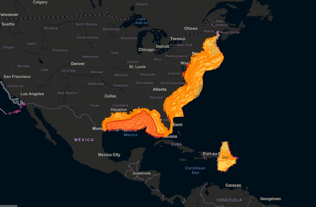
The National Oceanic and Atmospheric Administration (NOAA) maintains Fishmapper, an interactive mapping tool for examining important habitats for managed fish populations worldwide. Credit: NOAA
Overfishing disrupts the balance of marine life. When certain fish populations decline, predators lose their prey, and smaller fish can overpopulate. This creates even more problems in the ecosystem. Coral reefs, for instance, rely on fish to control the growth of algae. Without enough fish, algae can grow uncontrollably, killing the reef’s ecosystem.
The United Nations’ Food and Agriculture Organization (FAO) reports that more than one-third of global fisheries are overfished. Over the past 50 years, the number of overfished areas has tripled. A major factor contributing to this is bycatch, which is the unintentional capture of animals like sea turtles, dolphins, and sharks in fishing nets. Millions of animals are killed this way each year, adding to the damage in already struggling ecosystems. Sea turtles are often caught unintentionally by getting tangled in nets and are harmed before they can be freed. Similarly, endangered species such as certain whales and dolphins suffer high mortality rates due to poor fishing practices. Bycatch damages the biodiversity necessary for healthy ecosystems.
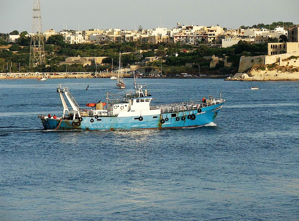
A trawler in Malta. Trawlers drag nets through the sea, either above the sea floor or along the sea floor. This method of fishing is indiscriminate and has negative impacts on sea ecologies. It is banned in many areas. Source: Peter Grima
The methods used in industrial fishing often cause harm to underwater habitats. Bottom trawling, for example, involves dragging heavy nets along the seafloor. While effective at capturing fish, this practice devastates coral reefs and seagrass beds, which are essential habitats for many marine species.
The Complex World of Fish Farming
To meet the growing global demand for seafood, many businesses have turned to aquaculture, also known as fish farming. On the surface, aquaculture appears to be a solution to overfishing, but it introduces its own set of environmental and ethical concerns. Farmed fish are often raised in overcrowded enclosures, which can lead to water pollution from waste.
Aquaculture relies heavily on fishmeal and fish oil derived from wild-caught fish, which means it continues to put pressure on already overfished stocks. Escaped farmed fish can further disrupt ecosystems by competing with native species for resources or introducing genetic and behavioral differences that harm wild populations.
Finding a Better Way
The negative effects of commercial fishing extend beyond the environment, impacting human communities. Illegal, unreported, and unregulated (IUU) fishing increases the problem. Operating outside the bounds of international and local laws, IUU fishing often targets the waters of vulnerable nations. This practice robs local fishers of their resources and disrupts efforts to maintain sustainable fishing practices.
Several actionable steps can mitigate the damage caused by commercial fishing. Stricter regulations on fish catch limits and the establishment of marine protected areas (MPAs) can help ecosystems recover and maintain biodiversity. MPAs provide safe zones where marine life can thrive without the pressure of fishing.
Technological advancements can also play a role by including selective fishing gear that can reduce bycatch. Consumers can make a difference by choosing sustainably sourced seafood, certified by organizations such as the Marine Stewardship Council (MSC).
Commercial fishing is essential for feeding millions of people around the world, but it comes at a cost. Our oceans, and the communities that depend on them, are under serious pressure from overfishing, habitat destruction, bycatch, and unsustainable fish farming. These practices are pushing marine ecosystems to their breaking point. The good news is that we still have a chance to make a difference. By enforcing smarter regulations, using better technology, and making informed choices as consumers, we can create a fishing industry that works well with the environment. If we act now, we can protect the health of our oceans and ensure they continue to provide for generations to come.
And that is Geography in the News, updated January 31, 2024.
Material in this article comes from “Gone Fishing, or, Who Will Catch the Last One?” (1999), an original article for Geography in the News by Neal Lineback, Appalachian State University.
Food and Agriculture Organization of the United Nations. (2020). The State of World Fisheries and Aquaculture 2020: Sustainability in action. FAO. https://www.fao.org/3/ca9229en/ca9229en.pdf
Martinez-Porchas, Marcel, and Luis R. Martinez-Cordova. 2012. “World Aquaculture: Environmental Impacts and Troubleshooting Alternatives.” The Scientific World Journal 2012, 1-7. https://doi.org/10.1100/2012/389623.
Overfishing: Catching fish faster than they can reproduce.
Bycatch: Sea creatures caught accidentally in fishing nets.
Bottom trawling: A harmful fishing method where nets are dragged along the ocean floor.
Aquaculture: Raising fish in farms for food, also known as fish farming.
Fishmeal: A food made from ground-up fish, often used to feed farmed fish.
IUU fishing: Illegal, unreported, and unregulated fishing that breaks fishing laws.
Marine protected area (MPA): Parts of the ocean where fishing is restricted or banned to protect ecosystems.
Marine Stewardship Council (MSC): An organization that certifies seafood as sustainable.
Questions for Discussion and Further Study
What are some of the main environmental issues caused by commercial fishing, and how do they affect marine life?
The article mentions how overfishing impacts local fishing communities and their ability to make a living. How do you think these communities might respond?
Do you believe fish farming could be a solution to overfishing? Why or why not?
What actions can governments, companies, and individuals take to make commercial fishing more sustainable for future generations?
Share
Register for Free
Create an account to get free access to exclusive AAG content.
AAG Members get exclusive access to publications, prominent journals, unique advocacy, grant, scholarship and professional opportunities with access to industry focus communities, and event discounts, including our annual meeting.
Some content may only be accessible if you belong to specific Specialty or Affinity Groups. You can still update your membership below. You will need to go through the Join flow, but you do not need to repurchase your membership unless it is expired or about to expire.
To provide the best experiences, we use technologies like cookies to store and/or access device information. Consenting to these technologies will allow us to process data such as browsing behavior or unique IDs on this site. Not consenting or withdrawing consent, may adversely affect certain features and functions.
Functional
Always active
The technical storage or access is strictly necessary for the legitimate purpose of enabling the use of a specific service explicitly requested by the subscriber or user, or for the sole purpose of carrying out the transmission of a communication over an electronic communications network.
Preferences
The technical storage or access is necessary for the legitimate purpose of storing preferences that are not requested by the subscriber or user.
Statistics
The technical storage or access that is used exclusively for statistical purposes.The technical storage or access that is used exclusively for anonymous statistical purposes. Without a subpoena, voluntary compliance on the part of your Internet Service Provider, or additional records from a third party, information stored or retrieved for this purpose alone cannot usually be used to identify you.
Marketing
The technical storage or access is required to create user profiles to send advertising, or to track the user on a website or across several websites for similar marketing purposes.
To provide the best experiences, we use technologies like cookies to store and/or access device information. Consenting to these technologies will allow us to process data such as browsing behavior or unique IDs on this site. Not consenting or withdrawing consent, may adversely affect certain features and functions.
Functional
Always active
The technical storage or access is strictly necessary for the legitimate purpose of enabling the use of a specific service explicitly requested by the subscriber or user, or for the sole purpose of carrying out the transmission of a communication over an electronic communications network.
Preferences
The technical storage or access is necessary for the legitimate purpose of storing preferences that are not requested by the subscriber or user.
Statistics
The technical storage or access that is used exclusively for statistical purposes.The technical storage or access that is used exclusively for anonymous statistical purposes. Without a subpoena, voluntary compliance on the part of your Internet Service Provider, or additional records from a third party, information stored or retrieved for this purpose alone cannot usually be used to identify you.
Marketing
The technical storage or access is required to create user profiles to send advertising, or to track the user on a website or across several websites for similar marketing purposes.


 At the 2025 AAG Annual Meeting in Detroit, I had the incredible opportunity of serving as both a session chair and presenter for the 11th Symposium on Human Dynamics Research. This year’s symposium, themed “Human Dynamics and GeoAI,” marked a major evolution of geographic thought—building on a decade of intellectual contributions that have redefined how we understand human-environment interactions in increasingly multifaceted physical and virtual worlds. Thanks to Dr Xinyue Ye, Department of Landscape Architecture and Urban Planning, Texas A&M University and Dr Xiao Huang, Department of Environmental Sciences, Emory University, for allowing me to take up such a monumental adventure—one that has shaped my experience of AAG for the better.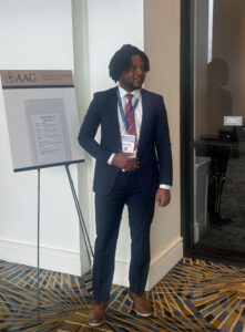

 Cadence Bowen is a senior at Kent State University majoring in Geography with a minor in Geographic Information Science (GIS). Originally from rural Arkansas, her move to the densely populated Northeast Ohio region led to her fascination with the distinction between rural and urban geographies. Her interests include tourism in rural fishing communities, Native American and Alaskan Native geography, regional disparities in early geographic education, environmental gentrification, and urban mapping techniques using open-source GIS. Her goal as a geographer is to advocate for the importance of geographic literacy through forms of digital media sharing. Outside of her academic goals, Cadence enjoys spending her summers traveling and taking on seasonal positions. Last summer, she spent her time working in the service industry in Seward, Alaska, learning more about how tourism affects economies that rely heavily on commercial and sport fishing and local indigenous communities, specifically the Qutekcak Native Tribe. She is super excited to take on the role of being AAG’s Media and Science Communications intern this summer and expand her knowledge of geographic research and media.
 Wyatt Gaines graduated summa cum laude from West Virginia University in May 2025 with a major in International Studies and minors in Geographic Information Science and Conservation Ecology. His interdisciplinary academic background informs his interest in applying geographic research to real-world challenges—a passion he brings to his work with the AAG and its diverse initiatives. Outside of academics, Wyatt enjoys weightlifting, studying languages, and watching movies. Since graduating, he has moved to Japan to work part-time as an American Youth Ambassador at the American Pavilion at the 2025 Osaka World Expo. He is honored to serve as one of AAG’s Community Support interns for the summer term. After his time with AAG, Wyatt plans to continue working in the NGO and nonprofit sectors and pursue graduate study.
 Geography in the News is an educational series offered by the American Association of Geographers for teachers and students in all subjects. We include vocabulary, discussion, and assignment ideas at the end of each article.