GeoHumanities

Op-Ed: #KickOutTheKKK: Challenging White Supremacy at UNC

Figure 1. UNC students protesting for the renaming of Saunders Hall as Hurston Hall (courtesy of The Daily Tar Heel/Claire Collins)

On May 28, 2015, the Board of Trustees at the University of North Carolina (UNC) at Chapel Hill voted to rename Saunders Hall—the building in which the Geography Department is located—following months of student protest that garnered national attention. Nearly a century ago, this building was named in honor of William L. Saunders (1835—1891), a white supremacist who played a leading role in the Ku Klux Klan of North Carolina during the nineteenth century. When the name was bestowed in 1920, the university’s Board of Trustees listed Saunders’ leadership in the KKK as one of his accomplishments deserving recognition. Naming a building for Saunders was therefore a clear attempt to inscribe the legacy of white supremacy into the very fabric of the university’s cultural landscape. And the fact that the building’s name endured for over 90 years speaks to how legacies of anti-black racism are a largely unquestioned and taken-for-granted aspect of our everyday surroundings, both on and off university campuses.  We say “largely” because the power of every racialized landscape never goes completely unchallenged, and Saunders Hall was no exception.

Over the years, students led various efforts to have this building renamed, particularly during the anti-apartheid struggles of the 1980s and early 1990s. For example, 25 years ago, students published an op-ed about Saunders’ legacy in the independent student newspaper at UNC, declaring: “Building should not be named for former KKK grand dragon” (Robinson and Hafer in Daily Tar Heel, 1990). These calls to rename Saunders Hall encountered institutional resistance and were largely ignored by university administrators (Chapman, 2006; Babatunde, 2015).

When resistance to renaming places is articulated, it usually takes the form of an argument that the act of renaming will “erase history”—an argument that surfaced, in recent debates over renaming Saunders Hall, among some progressive as well as conservative voices. Yet a distinction must certainly be drawn between acknowledging the past and bestowing honor upon a historical figure through commemoration. The naming of university buildings after individuals is, without question, a case of the latter. As UNC’s Policy on Naming University Facilities and Units states, “[t]he act of naming a University facility or unit for a person … is the conferral by the University of a high and conspicuous honor.” Maintaining a building named in Saunders’ honor, particularly in the face of anti-racist calls to remove it, thus signified the university’s ongoing commitment to honoring the legacy of white supremacy on campus.

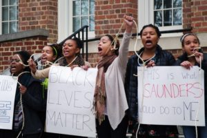
Even in 2015, the campaign to rename Saunders Hall was hard fought and proponents, who included geography faculty and students among others, faced considerable opposition. The student activist group, The Real Silent Sam Coalition, held protests on campus and via social media that galvanized national media coverage, drawing on a creative array of tactics—from performance art, the spoken word, poetry, a capella singing, artwork, t-shirts, banners, a manifesto, and the #KickOutTheKKK hashtag to the dramatic reenactment of racist speech from a 1913 Confederate memorialization on campus. The coalition also reproduced a document from the university archives, and regularly posted it around the building all spring, illustrating that the building had not been named despite William Saunders’ role in the KKK, but in fact because of it. Saunders’ position as “Head of the Ku Klux Klan of North Carolina” was indeed acknowledged in Board of Trustees’ proceedings in 1920 as one of his positive contributions, listed only after his status as a Confederate officer, and above his positions as Secretary of State, Treasurer, and Compiler and Editor of the Colonial Records of North Carolina. While the latter position has been the one most frequently identified by the university in recent years as the main reason for naming Saunders Hall, which then housed the History Department, it is evident that much more was at play in naming the building after Saunders as “one of the master minds of North Carolina,” amounting to a kind of victory lap for supporters of the KKK in the state and the university. Shedding light on this history of white supremacy in the campus landscape, the protests garnered support for change among UNC students, staff, and faculty, along with opposition, compelling the Board of Trustees to respond.

In May 2015, the Board of Trustees eventually approved the removal of Saunders’ name from the Hall in a 10-3 vote, but they also passed a 16-year moratorium on any further campus name changes and chose the generic and booster-laden name of “Carolina Hall” to replace that of Saunders, reflecting deep anxieties over the conservation of the university’s signature landscape at a moment of rapid cultural change. The renaming of Saunders Hall is an important achievement but in some ways remains a low bar to set for the naming of university buildings; that is, for students to take classes in a building that is not named for a KKK leader from a brutal period of racial terror in central North Carolina.

Student activists had demanded—and continue to demand—that the building carry the name “Hurston Hall,” to memorialize African American writer Zora Neale Hurston and challenge UNC’s gendered politics, as well as its racialized politics, of public memory (The Real Silent Sam Coalition, 2015). During the 1930s, Hurston was the first black student to attend UNC when she studied with Pulitzer Prize-winning playwright Paul Green. Since African Americans were not allowed to enroll during the Jim Crow era, there is no official record of Hurston’s attendance. UNC’s Board of Trustees used this fact to avoid consideration of Hurston’s name despite strong and vocal student support. Seventy-five years ago, when courts forced the university to desegregate (at least on a token basis), it was African American men who were first enrolled, revealing the complex entanglements of racism and sexism in the campus’ lived history. Even today there are only 16 buildings named for women at UNC, with the vast majority of cases being those of women who were part of a joint naming with their husbands. Only 8 UNC buildings are named for African Americans, and women of color are remembered in the monikers of a mere 4 campus buildings (or 2.5% of the total).

Importantly, the Real Silent Sam Coalition’s struggle in Chapel Hill is part of a growing movement to reconsider why college buildings are named after white supremacists (Svokos, 2015). Such debates are particularly active at schools in the South, such as Clemson, Duke, East Carolina, Radford, and Winthrop, yet similar efforts have arisen across the border in Canada as well. In British Columbia, for instance, students at the University of Victoria unsuccessfully lobbied to rename Joseph Trutch Residence Hall in 2010, which honors a politician known for dramatically reducing First Nations reserve lands in the province. One key challenge for activists is that momentum behind student-led movements is hard to sustain from one cohort of students to the next, a fact university administrators use to their advantage by simply waiting for collective amnesia to sink in again once a vocal group of students graduates. In such cases, faculty can help sustain the memory of past struggles by sharing the history and tactics of social movements with each incoming cohort of university students.

As the situation in Chapel Hill illustrates, geographers are especially well-equipped to play a leading role in social justice struggles over the production of commemorative landscapes on college campuses and beyond. In particular, the discipline of geography has much to offer to understanding and intervening within debates over the politics of place by challenging institutional authorities and university communities to reassess the meanings, values, and identities inscribed into campus geographies through place naming and other forms of commemoration. Even after name changes are made, the need among students for understanding both the contemporary and historical contexts of symbolic practices of naming are no less acute; perhaps more so, as the case of the newly dubbed Carolina Hall suggests.

While some of the most provocative ideas about anti-racism and social change originate at universities, academic geographers could surely do much more to challenge the complicity of their own campus landscapes in perpetuating racism and sexism. With this mind, we call on our fellow geographers at other universities to begin conducting close and critical readings of their own university campuses, engaging the student body and broader public in challenging the legacy of white supremacy that has been etched into the names of buildings, streets, stadia, and parks that collectively form the commemorative landscapes of higher education in America.

Reuben Rose-Redwood, University of Victoria
Derek Alderman, University of Tennessee at Knoxville
Altha Cravey, University of North Carolina at Chapel Hill
Scott Kirsch, University of North Carolina at Chapel Hill
Omololu Refilwe Babatunde, University of North Carolina at Chapel Hill
Josh Inwood, University of Tennessee at Knoxville

DOI:10.14433/2015.0017


References

Babatunde, Omololu Refilwe (2015), Black Liberatory Senses of Place: Creating from Abject Othernessundergraduate honors thesis, Department of Geography, University of North Carolina, Chapel Hill, NC.

Chapman, John (2006), Black Freedom and the University of North Carolina, 1793-1960, doctoral dissertation, Department of History, University of North Carolina, Chapel Hill, NC, <https://cdr.lib.unc.edu/indexablecontent/uuid:9797fe2f-6cb9-4e40-8674-619fa3a597b4>, last accessed on June 16, 2015.

Robinson, Keith and Claire Hafer (1990), “Building Should Not Be Named for Former KKK Grand Dragon,” The Daily Tar Heel, November 12, p. 11.

Svokos, Alexandra (2015), “Why Are College Buildings Still Named After White Supremacists?” Huffington Post, June 11, <https://www.huffingtonpost.com/2015/06/11/college-buildings-white-supremacists_n_7554958.html>, last accessed on June 16, 2015.

The Real Silent Sam Coalition (2015), “The Real Silent Sam Coalition: Manifesto 2015,” The Siren: Online Magazine, April 6, <https://uncsiren.com/real-silent-sam-coalition-manifesto-spring-2015>, last accessed on June 16, 2015.

    Share

Campbell W. Pennington

Campbell Pennington, a distinguished geographer who spent his career studying the material cultures and languages of indigenous peoples of northern Mexico, passed away on June 13, 2015, aged 97.

Campbell White Pennington was born on February 2, 1918 in Campbell’s Corner (now Farragut), Tennessee, moving to Austin, Texas, in the early 1920s with his parents, six brothers and a great aunt.

Education and culture were integral parts of Pennington’s upbringing, due in large part to the influence of four women. Foremost among these was his mother, a graduate of Wofford College, who insisted that her children read and “behave in a proper way.” In the home of two spinster sisters who lived across the road he was exposed to art, oriental rugs, pressed linens, classical music, porcelain and crystal, sterling cutlery, fine food, and language, while another lady neighbor gave him piano lessons.

Pennington often recalled the time his father gave him 25 cents, put him on a streetcar, pointed toward the University of Texas (UT), and said “Scat!” At UT, he completed a BA in history (1947) and an MA in sociology (1949). He also met Donald D. Brand, a prominent Latin Americanist geographer, who would not entertain thoughts of him pursuing a PhD at Johns Hopkins or Syracuse, insisting instead that he go to the University of California at Berkeley.

The notion of studying in the Bay Area was met with enthusiasm, as Pennington had enjoyed the culture of San Francisco while on leave from his Army duties at a POW camp for captured German soldiers.

Pennington’s days at Berkeley produced some of his fondest memories, especially of people, including William M. Denevan, Yi-Fu Tuan and James J. Parsons. But it was the great Carl Sauer who was his intellectual hero. When Pennington expressed an interest in the native people of the Sierra Madre of northern México, it was Sauer who endorsed him without reservation.

Pennington set out in the early 1950s to conduct field research in what would become his “beloved Chihuahua.” In no small way, his interest in northern México was sparked by his great uncle, Gordon Campbell White, who was director of the Mexican division of the Southern Pacific Railroad in the early 20th century.

Completed in 1959, Pennington’s dissertation was published with the title “The Tarahumar of Mexico: Their Environment and Material Culture” (1963, 1996). Subsequent research resulted in books on The Tepehuan of Chihuahua: Their Material Culture (1969) and The Pima Bajo of Central Sonora, Mexico (1980). He never finished The Mountain Pima of Maicoba, Sonora: Their Material Culture but chapter drafts and notes are archived in the Nettie Lee Benson Latin American Library at The University of Texas at Austin. Plants he collected while conducting field work in México were identified by B.L. Turner and are curated in UT’s herbarium.

In the course of conducting field research in places accessible only by mule or on foot, he also did archival research. Records maintained by 17th and 18th century Jesuit missionaries were of particular fascination, in part because of what they said about material culture, but also because of what they contained in regard to indigenous languages. Pennington compiled dictionaries of three Sonoran languages, two of which are now extinct, Ópata and Eudeve. The former was never published but exists in manuscript form in the Benson Library while dictionaries of Pima and Eudeve in 1979 and 1981 respectively.

All of his writing was done on a typewriter, much of it on an IBM Selectric. Close friends remember well his quest for a type ball with foreign letters and accents! Pennington was the consummate letter writer. Although he never relinquished his typewriter–using it later for notes and envelopes–he was an early adopter of computers. He purchased his first when he was 80 years old, and quickly began using email and was adroit with the internet.

A teacher as well as a scholar, Pennington held three academic positions. The first was at the University of Utah (1957-1964), an institution with a strong reputation in the publishing of research on native peoples of the Americas. Next, he went to Southern Illinois University (1964-1974) where he worked closely with anthropologists, J. Charles Kelley and Carroll L. Riley, producing a book entitled Man Across the Sea: Problems of Pre-Columbian Contacts (1971) that was translated and republished in Japanese. He also collaborated with geographer John F. Rooney on a project that resulted in the publication of This Remarkable Continent: An Atlas of United States and Canadian Society and Cultures (1982).

Pennington was enticed back to Texas, accepting the position as Head of the Department of Geography at Texas A&M University (1974-1984). With geography being alongside the departments of oceanography, meteorology and geology within the College of Geosciences, he insisted that his faculty become good teachers. He contributed to his own mandate by teaching a course on the geography of Texas that became popular almost immediately. His efforts paid off handsomely, and to this day the department teaches more students than the other three departments combined.

He was also a visionary who made some important hiring decisions that broadened the scope of the department’s previous narrow cultural focus. Notable in this regard was his hiring of geomorphologist Kenneth L. White, historical geographer Peter Hugill, and urban and quantitative geographer Robert Bednarz. He was also instrumental in establishing the career of Daniel D. Arreola, an acclaimed geographer of the Texas-México borderlands.

Pennington was an inspiration to scholars working in northern México, particularly Robert Bye, Gary Paul Nabhan, and William E. Doolittle. He instantly became a supporter and friend of anyone and everyone interested in the region, typically addressing them as “Young sir.” He held no sense of propriety, sharing freely information, experiences, insights, and wisdom. He was also a great supporter of undergraduate students, employing many as landscapers and home improvement carpenters.

Pennington underwent quadruple bypass heart surgery shortly after he retired. In order to be closer to family, he moved to San Marcos in the early 1990s, and later to Austin. He never expected to live as long as he did. After a cancer diagnosis, he had to have his bladder removed and recovered from the operation much to his own surprise. He moved back to San Marcos and considered himself fortunate to have the financial means to live comfortably for many years. The last several years of his life were enhanced by Frances Pedraza, who looked after his every need, patiently and respectfully.

Pennington enjoyed classical music and recalled fondly many of the concerts he attended, including two performances by Sergei Rachmaninoff. He had a large art collection that included paintings by Texas landscape artists Dawson Dawson-Watson and Julian Onderdonk. Food was also important to him. He had quite diverse tastes and was an excellent cook himself. His elegant dinner parties were very special occasions; a few graduate students found them overwhelming.

Although not reserved, Campbell Pennington was a beacon of tolerance and humility. He would doubtless say this memorial statement is: “apropos of absolutely nothing.” To those who knew him well, he was truly a larger-than-life character. As per his instructions, his ashes will be scattered in Copper Canyon in the Sierra Madre Occidental in the southwestern part of Chihuahua state of northwestern Mexico.

Contributed by William E. Doolittle, The University of Texas at Austin

    Share

NIMHD: Advancing Health Disparities Interventions Through Community-Based Participatory Research

Research supported by the National Institutes of Health (NIH) has resulted in an increasing growth in knowledge of the complexity of the interactive factors influencing health across the life course. There is extensive research evidence that report poorer health outcomes for socially disadvantaged populations, including low-income and racial and ethnic groups. Many community health promotion and disease prevention programs fail for various reasons that include the lack of a participatory approach or cultural sensitivity, despite the recommendation for tailored and multilevel interventions.

The National Institute of Minority Health and Health Disparities (NIMHD) within NIH has released a funding opportunity announcement (FOA), Advancing Health Disparities Interventions Through Community-Based Participatory Research (RFA-MD-15-010), seeking applications designed to support promising community interventions using community-based participatory research (CBPR) principles and approaches aimed at reducing and eventually eliminating health disparities. The FOA follows a 2012-issued FOA, NIMHD Community-Based Participatory Research (CBPR) Initiative in Reducing and Eliminating Health Disparities: Planning Phase, (RFA-MD- 12-006).

NIMHD’s CBPR program goal is to promote and support collaborative interventions that involve all of the relevant components in the translational research process: planning, implementing, evaluating, and dissemination. In the health disparities framework, this includes partnership approaches that focus on changing the determinants of health or the community conditions and environment. It is a research approach that may begin with a needs assessment to identify a health-related issue for action, or a community-led proposal on an identified need or matter of importance to the community.

For NIMHD’s purpose, the FOA identifies “community” as referring to a population that may be defined by geography, race, ethnicity, culture, gender, illness or other health condition, or to groups that have a common health-related interest or cause. Appropriate research intervention topics include, but are not limited to: adversity and chronic stress, tobacco use and substance abuse, healthy sexual behaviors, intentional or unintentional injuries and violence, preventive behaviors, and healthy lifestyle behaviors. The Institute is also interested in the specific research areas of multi-level interventions that include a combination of individual group and/or community-level intervention components, interventions that include health information technology applications and/or social media elements, and interventions that draw upon existing community resilience or strengths.

This FOA is open to current NIMHD CPBR planning grantees and their community coalitions, and to other applicants poised to implement and evaluate promising broad scale interventions using CBPR methods. The intervention study is required to take place in the U.S. or U.S. Territories or Possessions. Applications are due August 3, 2015.


Courtesy COSSA Washington Update

    Share

Harley Walker

Jess Walker, a noted American geographer who spent 60 years at Louisiana State University, passed away on May 30, 2015, aged 93.

Like many in U.S. geography’s first and second generations, Walker had rural Midwestern roots. Harley Jesse Walker, later known as Jess, was born July 4, 1921 in Michigan.

Soon after, his family moved from Michigan to Colorado and then in 1929 to California, a few months before the stock market crash. The family lived much of the next decade in a tent encampment near Morro Bay. Walker’s father bought a boat and made a living from the sea, bartering fish for produce from inland farmers.

Walker had multiple jobs during the Depression years, but managed to save enough in high school to start college at Berkeley in fall 1939. An avid explorer of local environments, especially the coastal zone, majoring in geography was a natural outcome.

With the onset of WWII, and Walker’s childhood fascination with flying, he enlisted in the Naval flight school at the beginning of 1942. During the war he served as a Marine Corps pilot in the Pacific theatre learning coastal and Pacific island geography first hand. After the war he returned to Berkeley to complete his undergraduate studies (BA 1947), and then his master’s degree in geography (MA 1954). His thesis was a study of rainfall in Mexico under the direction of John Leighly, but the initial inspiration came from a trip to Mexico with Carl Sauer in the summer of 1947.

Walker’s academic career actually began before finishing his master’s degree. In 1950, on the recommendation of Wilbur Zelinsky (then at the University of Georgia), he was hired as Assistant Professor to help set up a geography program at Georgia State College in Atlanta. He was preceded the year before by his fellow Berkeley student, Reese Walker (no relation), also a Leighly advisee and participant in the 1947 trip to Mexico. The two Walkers quickly laid the foundations for the department. In 1956 Jess Walker was named Chair.

During his tenure at Georgia State, Walker also managed to do course work and fieldwork in the Arctic for his doctorate at Louisiana State University (LSU). His study was entitled “The changing nature of man’s quest for food and water as related to snow, ice and permafrost in the American Arctic” and was under the direction of Fred Kniffen.

He spent much of 1955-57 commuting by bus between Baton Rouge and Atlanta. At Georgia State he taught courses in anthropology and geology as well as geography and built up the library’s holdings in geography. Walker oversaw the hiring of several additional geographers including fellow Berkeley student Campbell Pennington.

Walker spent the academic year 1959-60 in Washington, DC with the Office of Naval Research (ONR) under the direction of Evelyn Pruitt. In subsequent years, the ONR would be an important funding source for LSU geographers doing coastal studies and foreign area fieldwork.

Receiving his PhD in 1960, Walker was invited by Kniffen and Russell to join the LSU department as an assistant professor. In 1962 he became the departmental chair. The 1960s were boom times in America, and academia was no exception. The Department of Geography & Anthropology under Walker’s chairship (1962-1969) enjoyed healthy growth, doubling the number of faculty from five to 11. During this decade new geography faculty hires included: Charles “Fritz” Gritzner, Milton Newton, Robert Muller, Jonathan Sauer, Fred Simoons, and Donald Vermeer.

Walker’s eclectic interests and abilities allowed him to teach a variety of courses, including climatology, geomorphology, human-environment courses, and special offerings on his Arctic and coastal research topics. Walker ended the decade with another ONR assignment, this time in London where he and his family spent the academic year.

During the decade of the 1970s Walker continued to help build the department having expanded the physical geography program in the directions of climatology and biogeography with new appointments and visiting scholars. During the late 1960s through the 1970s Walker helped bring in a series of visiting scholars for periods of a month to a year. These visitors included: H. Aschmann, D. Brunsden, E.E. Evans, H.G. Gierloff-Emden, D.B. Prior, C.O. Sauer, W.L. Thomas, J.K. Wright, and E. Yatsu. Similarly Walker was integrally involved in hosting symposia that resulted in published volumes in the School of Geoscience’s Geoscience and Man publication series.

Walker also oversaw the creation of a number of new courses focused on coastal topics. Led by Walker, the LSU department became a major geographic center of coastal research and teaching. In 1977 Walker was named Boyd Professor, LSU’s highest academic honor and rank, thus joining Russell, Kniffen and Robert West (all with Berkeley degrees) becoming the fourth LSU geographer to achieve this status.

Walker’s formal teaching career ended in 1984 with his retirement, but he continued to oversee theses and dissertations until 1990. With retirement Walker may have been relieved of his teaching and administrative duties, but if anything, the pace of his research and service only accelerated. A world traveller with an impressive roster of places visited and conferences attended, in “retirement” Walker served as one of U.S. geography’s most seasoned and effective informal ambassadors abroad.

Accordingly, he was awarded a number of honors, including an honorary doctorate from Uppsala University, the Patron’s Medal of the Royal Geographical Society, Distinguished Career Award from the Association of American Geographers, and recognition from a number of other national geographic societies on several continents. He was also a Fellow of various scientific organizations including the American Association for the Advancement of Science.

His publications (books, articles, chapters) reflected his main research interests. Perhaps foremost are the Arctic topics, especially on his Colville River delta site (Alaska’s North Slope), his workshop during multiple field seasons. But Walker also did field work in tropical environments, including studies of Mauritius. More broadly, coastal places and processes were the objects of Walker’s global investigations, with special attention to East Asia (China and Japan) and Italy.

As emeritus professor (thirty plus active years in this role!), when not travelling, or conferring with colleagues in the field, or attending conferences, he was certain to be in his carefully curated office or laboratory writing up yet more material or researching new projects. During these years he also contributed to the history of geomorphology, with various publications including a large co-edited volume on The Evolution of Geomorphology (1993). Similarly he wrote memoriam pieces for the Annals of the AAG on Fred Kniffen and Evelyn Pruitt, and the entry for Richard J. Russell in Geographers: Bibliographical Studies.

Walker’s time and tenure at LSU, some sixty years – from start of his doctoral studies in the mid-1950s to the present, spans much of the department’s history. When he entered only the three Sauerians (Russell, Kniffen, West) and two of their students (William McIntire and John Vann) were on the geography staff. Walker not only oversaw the expansion and “diversification” of the faculty and program, but also subsequently helped keep the founding visions and directions in focus and on course.

Perhaps more than anything, Walker stood out for his fidelity to the department, university, and discipline. But at the same time, he was very much his own person, not someone to be easily emulated. Perhaps more than most, he was a product of his times. He epitomized what Tom Brokaw had in mind when he coined the term “The Greatest Generation.” From Depression Era deprivation, to daring service in WWII, to post-war boom and building, the trajectory was clear – upward and onward. In Walker’s case, and to most of all who knew him, his was a generous run — an arc bent only slightly with time — that still possesses some momentum.

Jess is survived by his wife Rita, sister Lois, three daughters Winona, Angie and Tia, nine grandchildren, and four great grandchildren.

By Kent Mathewson, Louisiana State Unviersity

    Share

Robert N. Thomas

Bob Thomas, emeritus professor at Michigan State University, noted for his scholarship on the geography of Latin America, passed away on May 8, 2015, at the age of 88.

Robert N. Thomas was born on July 17, 1926, in Pittsburgh. He studied first at Indiana University of Pennsylvania and earned a bachelor’s degree in geography and social science education in 1950. Following this he taught high school geography and science in Oakmont, PA, his former high school, and in the Hampton Township schools.

While teaching, he continued his own education, earning a master’s degree from the University of Pittsburgh in 1958. In 1960 he returned to Indiana University of Pennsylvania as a professor of geography and taught there until 1969. During this period he also undertook a PhD in geography at Pennsylvania State University and served as an urban planning advisor for the U.S. Agency for International Development in Guatemala (1965 and 1966), as well as supporting a young family.

One of his sons, Scott, reminiscing about his childhood, noted how his father encouraged travel and the discovery of new places; the family took every opportunity to take a trip somewhere. “When summer vacation time came around the corner, I think we sometimes just flipped a coin to decide North, South, East or West. By the time I was out of high school we had driven through every state in the Continental United States except for one.”

Not only that but “when my father was working on collecting data for his doctoral thesis we even drove all the way to Guatemala. Not once, but twice! And when more research was needed, we drove even further to spend a summer in Honduras.”

Scott also remembered lots of gatherings at their family house in Indiana of students from different nationalities from Japan to South America.

Having been awarded his doctorate in 1968, Thomas moved to Michigan State University (MSU) in 1969 to join the geography faculty, where he stayed until his retirement.

Thomas’ research interests were in the geography of Latin America, particularly population, migration and tourism. He traveled extensively throughout the Central American countries, Mexico, the Caribbean islands, and South America. In 1972 he was a Fulbright Scholar to Colombia.

He became the assistant director of MSU’s Latin American Studies Center in 1974 and its director in 1985. He authored and co-authored dozens of research articles published in academic journals and edited three books including Population growth and urbanization in Latin America: the rural-urban interface with John Hunter and Scott Whiteford (published 1981).

Thomas was a dedicated lecturer who greatly enjoyed teaching undergraduate courses, not only on the geography of Latin America, but also on the geography of North America and population geography. His classrooms were always full and students had only favorable comments about his courses.

Beyond the classroom, he took both undergraduate and graduate students on field experiences in Cuba, Mexico and across Latin America, exposing them to different cultures and environments.

He was a founding member of the Conference of Latin Americanist Geographers. He was also a member of the Association of American Geographers, the National Council for Geographic Education, American Geographical Society, National Geographic Society, and the Geography Commission of the Pan American Institute of Geography and History (PAIGH).

Thomas retired in 1990 but, as emeritus professor, continued to be active in research, writing, teaching and participating in departmental activities. Through MSU’s Office of Study Abroad he continued to direct and accompany students on international field experiences. He also worked on several monographs concerning his travels and experiences in Latin America. In 1999, Thomas and his wife established a Geography Endowment Fund at MSU to support geography-related student activities.

He also maintained a strong alliance with Indiana University of Pennsylvania over five decades, acting as a mentor to geography graduates and contributing to the Geography and Planning Faculty Scholarship Fund.

Beyond the two universities, he lectured on cruises to Latin America and also engaged in community service as a speaker for Rotary clubs and in public schools.

Thomas was named an honorary affiliate of the Pan American Institute of Geography and History in 2005. Indiana University of Pennsylvania honored him as a distinguished alumnus in 2007 for his achievements in academia, his contributions as an educator, his service as a mentor, and his authoritative knowledge of population geography and tourism in Latin America.

Despite declining visual ability, Thomas maintained his office at MSU, visiting the geography building almost every day, including the day he passed away. He inspired generations of students with a fascination for Latin America and was a major influence in the careers of many geography graduates. He will be missed tremendously by both colleagues and students.

Bob is survived by his wife Dorothy of 60 years, their two sons, Scott and Robert, his wife Cari, and their two sons Colin and Connor.

    Share

Pacific Coast Division Team Takes 2015 World Geography Bowl Title

AAG Pacific Coast Regional Division 2015 World Geography Bowl Champions

The Pacific Coast team won first place in the 2015 World Geography Bowl, an annual quiz competition for teams of college-level geography students representing the AAG’s regional divisions. This was the 22nd year for AAG hosting during its annual meeting.

On April 24, nine teams, each representing an AAG regional division, competed at the Hyatt hotel in Chicago. All nine regional divisions were represented by a team: East Lakes, West Lakes, Great-Plains Rocky Mountains, Middle Atlantic, Middle States, New England-St. Lawrence Valley, Pacific Coast, Southeast and Southwest Divisions. A spoiler team comprised of students present at the competition was added to round out the brackets. One of the spoiler team members, fourth-grader Ari Vogel from Wildwood Elementary School in Amherst, Mass., even scored for the team.

At the beginning of the exciting competition AAG President Mona Domosh addressed the crowd with an uplifting message and  at the end presented the winners with prizes.

The winning Pacific Coast Division team’s roster was:

  • Brendan Gordon, University of Idaho
  • Jesse Minor, University of Arizona
  • Noah Silber-Coats, University of Arizona
  • Laura Sharp, University of Arizona
  • Tina White (coordinator), Cypress College

The first runner-up Southeast Division team’s roster was:

  • Pete Akers, University of Georgia
  • Ronnie Schumann, University of South Carolina
  • Claude Buerger, University of South Alabama
  • Alejandro Molina, University of North Carolina- Greensboro
  • Rebecca Groh, University of Tennessee
  • Matt Cook, University of Tennessee
  • Dawn Drake (coordinator), Missouri Western State University

The second runner-up Middle Atlantic Division team’s roster was:

  • Christopher Hart, George Washington University
  • Kean Mcdermott, George Washington University
  • Madeline Hale, George Washington University
  • Michelle Stuhlmacher, George Washington University
  • Gloriana Sojo, George Washington University
  • Ziqi Li, George Washington University
  • Avery Sandborn, George Washington University
  • Tracy Edwards (coordinator), Frostburg State University

The top five individuals with best personal scores were awarded an MVP prizes. Listed in order of most points earned:

  • Christopher Hart, George Washington University
  • Pete Akers, University of Georgia
  • Kevin Bean, Bridgewater State University
  • Brendan Gordon, University of Idaho
  • Kate Rigot, University Of Colorado, Denver

WGB Founder and Retired Geographers Association members make a special appearance

As a special surprise to all, the founder of the World Geography Bowl Neal Lineback and other members of the Retired Geographers Association, including Richard and Susan Nostrand, Will Rense and Marvin Baker delivered eight boxes of delicious Chicago-style deep-dish pizza for the gathering crowd of contestants and audience members.

Thanks to 2015 WGB prize donors and volunteers

Organizers of the World Geography Bowl would like to express thanks to the countless volunteer question writers, team sponsors/coaches, moderators, judges, and scorekeepers who make the competition possible, and to the many students who competed throughout the country. We would like to recognize the volunteers this year as: Casey Allen (University of Colorado at Denver), Tom Bell (Western Kentucky University & University of Tennessee), Susan Bergeron (Coastal Carolina University), Michaela Buenemann (New Mexico State University), Laurence W. Carstensen (Virginia Tech), Jamison Conley (West Virginia University), Clinton Davis (Temple University), Richard Deal (Edinboro University), Lisa Dechano-Cook (Western Michigan University), Dawn Drake (Missouri Western State University), Rob Edsall (Idaho State University), Peggy Gripshover (Western Kentucky University), Tracy-Ann Hyman (University of the West Indies), Melvin Johnson (University of Wisconsin at Manitowoc), Frank LaFone (West Virginia University), Patrick May (Plymouth State University), Jon Moore (ETS), Jeffrey Neff (Western Carolina University), Lee Nolan (Pennsylvania State University), Colin Reisser (George Washington University), Wesley Reisser (US State Department & George Washington University), Angela Rogers (Pennsylvania State University), Zia Salim (California State University at Fullerton), Jodi Vender (Pennsylvania State University).

World Geography Bowl organizers thank its supporters who generously donated atlases, books, gift certificates, softwares, and MVP awards – Avenza Systems, The University of Chicago Press, The University of Georgia Press, Edward Elgar Publishing, Esri, Lonely Planet, MaxQDA, National Geographic Society, W. H. Freeman & Company and Waveland Press – who recognize the important role the competition plays in building a sense of community and generating excitement around geographic learning. Your continued support is truly appreciated.

Thanks to World Geography Bowl executive director Jamison Conley (West Virginia University) for his first year of leading the competition.

2016 World Geography Bowl – San Francisco

The 2016 World Geography Bowl competition will be held in San Francisco in April, 2016. Regional competitions typically occur during the fall at respective AAG regional meetings, where regional teams for the national competition are usually formed. For more information on organizing a team, contact the World Geography Bowl executive director, Jamison Conley, at West Virginia University at Jamison [dot] Conley [at] mail [dot] wvu [dot] edu or Niem Huynh at nhuynh [at] aag [dot] org.

Note: This post has been edited to reflect that it was the 22nd annual event. A previous version stated it was the 26th annual event.

    Share

Chicago: Food City

In 2011, Michelin released its first “red” guide to Chicago restaurants and hotels. Chicago became the third city in the United States, after New York and San Francisco, to have a red guide. To some, this may seem like a minor matter, but the red guide is a marker of culinary excellence for gourmets, and its release was a sign of how important of a destination Chicago has become for culinary tourists.

High-end restaurants have bloomed in Chicago in the past 20 years. Current tourists come to experience places like the molecular gastronomy temple Alinea, currently listed by one source as the ninth best restaurant in the world. Chef Grant Achatz takes apart foods into basic components, and reconstructs them into beautiful (and very expensive) concoctions. Grant Achatz’s other restaurant, Next, features a new cuisine every few months. Like Alinea, one buys pre-paid “tickets” rather than making reservations. At Next you can buy season tickets for the various incarnations of the restaurant, in the same way you purchase a theater subscription (hint for AAG gourmands, if you sign up to their Facebook page, a couple of tables usually are available each day). Other places such as Avez, the Gage, Girl and the Goat, and Publican feature Midwestern ingredients especially house-cured meats.

While these high-end restaurants may bring tourists to the city, Chicago is as least as famous for its hearty everyday foods. These include the Chicago hot dog, topped with mustard, tomatoes, grilled or raw onions, a pickle spear, “sport” peppers, and celery salt, and the even heartier Italian beef, a roasted beef sandwich somewhat like a French dip, served on Italian bread, and topped with hot or sweet pepper. It is particularly delicious dipped back into the gravy. Both of these sandwiches grew out of the Depression years, providing a cheap meal to hungry Chicagoans. The World War II era saw the invention of the deep-dish pizza, a similarly hearty meal in one dish (and one slice). Later, Chicago was the site of the invention of the gyro sandwich (at least the ground lamb and beef on a rotating skewer variety), and more recently, the Puerto Rican jibarito, a steak sandwich served between two mashed and fried plantain slices (vegetarian and other varieties are now also available).

Chicago is not a food city just because of the food that is served here. From its beginning, Chicago has been a place that processed, stored, and sold the ingredients of the Midwest. Chicago was the US capital of industrial candy manufacturing, home or former home to Brach’s, Mars, Toostie Roll, Curtiss Candies (makers of Baby Ruth and Butterfinger bars), Wrigley’s gum, and many others. While many of these plants and companies are now gone, the Mars plant still makes candy on the far west side, and Tootsie Roll is still on the southwest side. Nestlé bought Curtiss Candies but manufactures candy bars in the same plant as before, just south of O’Hare airport. Still today, if you take a walk west along the north bank of the Chicago River, past the Merchandise Mart, and then cross the north branch of the river at Kinzie, you may start smelling chocolate. This comes from Blommer’s, the largest processor of chocolate in North America, and supplier to many other manufacturers, which is located just beyond the river.

Probably the most famous Chicago sites related to industrial food are the Chicago Board of Trade and the Chicago Union Stockyards. The Board of Trade began as an association of grain buyers and sellers who traded along the south bank of the Chicago River, but soon developed into the largest grain exchange in the world. It is now part of CME Group, having merged with the once much smaller Chicago Mercantile Exchange, which itself began as the Chicago Butter and Egg Board. The Board of Trade Building, located prominently at the south end of the LaSalle Street urban canyon, is worth a tour. Topped by a faceless statue of Ceres, the Roman god of grain, the Arc Deco building’s interior is filled with sculptural allegories to grain. The Chicago Union Stockyards closed in 1971, but the stockyards area, on the near southwest side, still hosts one meatpacker, and The Plant, a vertical farm and food business incubator, which at the moment includes a kombucha manufacturer, two aquaponics companies, a bakery, and a sustainable indoor prawn farm.

The Plant is one example of how urban agriculture has been growing in the Chicago area. Others include two for-profit large-scale aqauponics facilities, non-profit urban farms including the Chicago branch of Milwaukee based Growing Power, and Growing Home, a work-training program in the Englewood neighborhood, and many others. Community gardens now dot many Chicago neighborhoods. While this may all seem new, in many ways it brings the city back to its roots. Much of Chicago was once a swamp, but after being drained, much of it was also very good agricultural land. Sandy Lake View was once a leading producer of celery. What is now the South Side was a produce producing area, and part of the North Side was covered with greenhouses, producing flowers and other plants for the city. The area near O’Hare (once called Old Orchard) was a farming zone, also largely producing for the city, but also producing peas and other vegetables for canning by Chicago-based Libby’s.

At its very beginning, the town of Chicago was consisted of collection of taverns and houses that were built between 1829 and 1833 around “Wolf Point,” at the confluence of the North and South branches of the Chicago River. The most famous of these was the Sauganash Hotel, where proprietor Mark Beaubien would play the fiddle while townsfolk and hotel patrons danced. Hearty food was served. Today, the flow of the river has been reversed, and the river is wider, but Chicago still is a place that welcomes its visitors with hearty food and good cheer, as well as more gourmet possibilities. Enjoy your time in our city and eat well.

—Daniel Block
Chicago State University

DOI: 10.14433/2015.0012

    Share

Surveillance and Policing in Chicago…and its Discontents

Geraint Rowland via Compfight

In the aftermath of the 2013 Boston Marathon Bombing, Chicago received national attention for its comprehensive network of surveillance cameras. One of the first U.S. cities to make extensive use of surveillance cameras, beginning in June 2003, the Chicago Police had launched “Operation Disruption,” a multi-phased plan to install “blue-light” Police Observation Device cameras (PODs) in high crime areas. Able to rotate 360 degree and zoom to a fine level of detail, bullet proof, operable in any weather condition, these cameras record continuously and switch into night vision mode after dark. They are used to monitor street crimes and direct police deployment. In 2006, “Operation Disruption” gave way to “Operation Virtual Shield,” a scheme to create the most extensive and integrated video surveillance network in the United States. In January 2007, the city began installing cameras at least 20 high schools. Under Mayor Rahm Emanuel, the city has added 500 more and now has an integrated system of 22,000 cameras citywide (see map). This system includes the “blue-light” street cameras as well as cameras on CTA trains, buses, and public transit stations and cameras installed on public buildings such as schools and Chicago Housing Authority facilities. As part of “Operation Virtual Shield,” the city upgraded cameras to incorporate facial recognition and “automatic tracking” or the ability to follow a person or vehicle from one camera to the next. Today, the data from these cameras is wirelessly transmitted to the Chicago Crime Prevention Center (CPIC) which also can individually control any camera (Chicago Police Department 2013a; 2013b).

CPIC is one of 78 fusion centers recognized and partially funded by the Department of Homeland Security. With a potentially limitless “all crimes, all threats, all hazards” mission, the CPIC operates 24 hours a day from the fourth floor of police headquarters at 3510 S Michigan Ave. It has a regular staff of 30 to 35 people. Personnel from FBI, DHS, and Illinois State Police are assigned full time to the CPIC, while personnel from other agencies including the Illinois Department of Corrections, Cook County Sheriff’s Police, State Department, Metra Police, DHS Customs and Border Protection, U.S. Secret Service, U.S. Attorney’s Northern District of Indiana, Transportation and Security Administration and various suburban police departments also deploy the CPIC as needed (Chicago Police Department 2013b). The CPIC is an information clearinghouse and analytic center that analyzes long term trends, monitors the “threat environment” to achieve real time “situational awareness,” and provides tactical case support. In the latter capacity, the fusion center provides “real-time violent crime detection monitoring and response, continual assessment of available resources for the purpose of possible redeployment of manpower, instantaneous major incident notification, analysis and identification of retaliatory violence and automated construction of enforcement missions to thwart retaliatory violence, crime pattern identification, and immediate access to in-depth background data on persons of investigative interest” (Government Accountability Office 2007: 70).

Fusion centers like the CPIC are associated with intelligence-led policing (ILP). ILP operates on two fronts. One the one hand, ILP is “a top-down management approach” that “uses crime intelligence to objectively direct police resources decisions” and offers a “business model and managerial philosophy where data analysis and crime intelligence are pivotal to an objective, decision-making framework that facilitate crime and problem reduction, disruption and prevention through both strategic management and effective enforcement strategies that target prolific and serious offenders.” On the other hand, ILP reorients policing around intelligence in an effort to shift the profession toward the pre-emptive disruption of crime. This future-oriented mode of policing entails the individual targeting of chronic offenders, using informants and surveillance to identify and track them (Ratcliffee 2008: 6, 83-87). In Chicago for example, analysts at the CPIC evaluate an individual’s parole or warrant status, weapons or drug arrests, arrest histories of the person’s acquaintances, and whether they have been the victim of a shooting to generate a “heat list” of individuals “500 times more likely than average to be involved in violence” (Gorner 2013; Flannery 2014).

While fusion centers and ILP are considered by some to be the future of law enforcement, the centerpiece of the so-called “Homeland Security Era” of policing in the United States, they also raise a series of concerns related to civil liberties violations and political policing. In Chicago, the CPIC has recently been implicated in the illegal surveillance of activists associated with the Black Lives Matter protest. “Police scanner enthusiasts” found evidence that the Chicago Police were using StingRay devices—the brand name of a device made by Harris Corporation to simulate a cell tower’s radio signal and capture data from nearby mobile phones, tablets and similar wireless devices—to monitor the Ferguson solidarity protests. The intercepted communications revealed that this data was being sent to the CPIC (Handley 2014). Like all issues surrounding intelligence generally and fusion centers specifically, these allegations are obscured by official secrecy. The Chicago Police are currently being sued to release documents that would prove that the department owns a Stingray device (Smith 2014).

Such secrecy may not last long. The lawsuit and ongoing protests around police abuses are developing into a broader effort to assert community control over the police. The Chicago Alliance Against Racist and Political Repression (undated) is organizing a drive to pass legislation that would create a Civilian Police Accountability Council with powers to appoint the police commissioner, rewrite the police rule book, investigate police shootings, and otherwise oversee the police department. A coalition of grassroots groups are planning a demonstration this August in support of the legislation and are already pushing alderman to support the legislation. Outside of Chicago, the proposal is attracting attention of other activists in other cities, including Baltimore and St. Louis, who are considering launching similar campaigns.

—Brendan McQuade
International Studies
DePaul University

DOI: 10.14433/2015.0011


References
    Share

New Books: March 2015

Every month the AAG compiles a list of newly-published books in geography and related areas. Some are selected for review in the AAG Review of Books.

Publishers are welcome to send new volumes to the Editor-in-Chief (Kent Mathewson, Editor-in-Chief, AAG Review of BooksDepartment of Geography and Anthropology, Louisiana State University, Baton Rouge, LA 70803).

Anyone interested in reviewing these or other titles should also contact the Editor-in-Chief.

March, 2015
    Share