Education: Bachelor’s degree in Geography (Dartmouth University), MSc in Geographical Information Science (University of Edinburgh)
The following includes an interview conducted with two colleagues at Webster Pacific. Although the conversation with both William Blomstedt and Tom Paper is included below, a duplicate profile is also available for Tom Paper, who is Managing Partner at Webster Pacific.
It was compiled by Jessica Embury (San Diego State University) for the Encoding Geography initiative. To learn more, visit: https://www.ncrge.org/encoding-geography/
Please describe your job, employer, and the primary tasks that you perform in your position.
Tom Paper (TP): Our company is Webster Pacific and we provide analytical consulting services. We’ve been in business for almost 20 years and our clients are in a wide range of industries. I used to be a strategy consultant at Bain and Company a long time ago.
We use tools like Python, ArcGIS, Tableau/PowerBI, CRM/ERP, Cloud Databases, and SQL Server to perform coding, geo-analysis, marketing analytics, web scraping/research, interviewing, and financial analysis. I can’t use any of these programs but I understand the logic of all the work that we do, much of which is geocomputational.
William, do you want to add anything? You have a background in geoscience.
William Blomstedt (WB): I studied geography as an undergrad and then I did a master’s course in GIS so I came to the field that way. Tom, geospatially, you only started more recently doing geospatial stuff? The work evolved to geospatial analysis.
TP: That’s right, seven years ago, one of our clients – a private school based in Manhattan – wanted to open up schools in cities all over the world and asked us to help them analyze cities as opportunities for locating new schools. And that’s what launched us. We evolved our geospatial capabilities for this particular client to help other clients and other schools think geospatially about new locations. We just helped a preschool in Washington DC and we also helped a private school think about why a location in San Francisco had not been performing as well.
What is your educational background and how did you initially discover geocomputation and ultimately choose a career using geography and computer science?
TP: My background was liberal arts. I studied economics and environmental studies at Williams and so I don’t know whether the career chose me or if I chose the career. It feels a little bit like it chose me. I think for William – he chose it, he was more curious geospatially early on.
In the last five years, pretty much since we started geospatial analytics, I got interested in antique maps and that process of discovery. I think there’s a very real thread between our work and the kind of work that people did to think about exploration. For example, I have a map of California as an island from the 17th century. I think it was George Box who said, “All models are wrong, but some are useful.” Examples of things being wrong fascinate me because we see that every day, or we know our models are wrong, but the question is whether they are helpful.
When thinking about geography, what specific background knowledge and conceptual ideas do you think are important and useful?
TP: I think that the ability to think in the weeds and then to think about the forest is the most important skill that we have. To be able to go back and forth between details and the big picture. I don’t have a geographic education but I think that ability is critical to what we do every day.
WB: When I was choosing to go to school to pursue geography, someone told me that you could take a GIS course that just teaches you how to use the program and do GIS. However, they advised me to go to a course where you do a thesis where you have to solve a problem, and GIS is the tool. Instead of just learning the tool, you need to use the tool to do something with it and think about the big picture, rather than just doing geographical analysis.
When thinking about computer science, what specific background knowledge and conceptual ideas do you think are important and useful?
TP: I think the willingness to accept that you don’t know everything and that there are things that we still learn. Repeatedly, we learn things and how to do things that we didn’t know before, so I think the willingness to accept that you don’t know everything is critically important.
Can you mention any procedural knowledge that you think is particularly useful from the standpoint of either geography or computer science?
TP: We see geography and computer science, or geospatial, like they’re melded together: geography and computer science and our use of programs.
We use Excel and Google Sheets all the time because it’s how we get into the details and also get to the big picture. Now we’ve had a lot of young people join our firm and want to use Python instead of Excel. I’m not sure I would say that I have embraced it, but I can see the power of it. No matter how programmatic they get, it is important that our team understands how to come back to the larger questions and more conceptual ways of displaying what we’re doing.
We’re fortunate in the sense that we are driven by our client and their strategy. Every client has a different definition of what is a customer to them and their market position. The priorities are the activities that support that market position and determine who is a customer, and how to spatially define a customer in a particular space. We often think about time. We do find that mileage is not good because a mile in New York City and a mile in Los Angeles are very different due to the time it takes people to get to and from things.
What’s an example of a social, economic, environmental or other issue that you recently investigated in a project?
TP: Our client wanted to find a location within a metropolitan area and the customers who would go to their store. Customers are only willing to travel so far. So we wanted to locate in a place where there’s more demand than competing supply for this company. We created a map to show demand and supply in the market. The basic point was to figure out where there’s more demand than supply. Geospatially, where does that exist? We took the demand and subtracted out the supply to get our answer. If all you were doing was looking at the demand, you’d get an answer that looks very different.
What kind of questions did you ask and think about during this project?
WB: It’s all about location, place, and interconnection. If we need to write a code or an algorithm, we do it to either iterate faster or to make a model. For a simple supply model, we can say the supply is all in one point. In a more complex model, we will say the supply is not exactly in that point but it’s around that point (e.g. within 10 minutes) and so we have to build a model which spreads that supply out and then computationally figure out where all the supply is.
What types of data did you acquire to support your project, and are you able to identify up to three data sets that you use frequently?
TP: We use Census data a lot.
WB: American Community Survey.
TP: We use lists of schools or stores on the web. Our client will also have data about their customers and information that we will integrate into our analysis.
But Census data is by far the biggest one. For the census data, we deal with shapefiles. Sometimes we get data by Block Group, Census Tract, county, or something else. Then, we have to turn that data into data that meshes with us.
We use road network data sometimes. We used to build our own road networks, and now we use outside services who have data about traffic speeds. Road networks are really important to conceptualize something timewise. Sometimes we’ve thought about not just drive time but walk time or subway time. We analyzed some things in Tokyo once and we had to make a road network, if you will, that was based upon subway travel times.
What types of content knowledge and skills did you use to evaluate, process, and analyze the data you gathered for your project?
TP: I have a whole presentation, called the consulting toolkit, about the kinds of thinking that we have to go through to work successfully. People don’t necessarily know all the data that they’re going to need and they don’t necessarily have all the skills to solve a problem, so being able to pick things up quickly is really important.
We’ve talked in our firm about letting the data guide you and being careful to let the data explain to you what it says. Our customers have questions and we need to be careful to not over interpret the data or over explain the data.
We always have to look at the work that we’ve done and ask whether it makes sense. Sometimes it doesn’t make sense because we made a mistake. There are so many calculations involved in what we do, so we need to go back and see if we made a mistake. For example, William and I just got through with a particular city and there was a pocket of demand close to the core area. It didn’t make sense to us that it would exist there, so we went back and checked the calculations and discovered that there was a river creating a barrier. So, in this case, there was a geospatial reason.
How did you apply geography and computer science to communicate the results of your project?
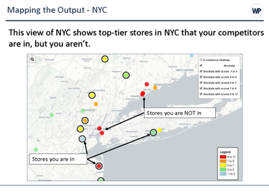
TP: This map is for a retail fashion company. They sell their products to wholesalers who resell the product to consumers. They wanted to know which stores (wholesalers) they should sell their product to, so we found out where the competitors were located.
That’s the coloration of the dots. Every dot is a store and the reddest dots have the most competitors located inside of them. The black circle around the dots indicate stores where our client is located. Our client was in only one store where there were a whole bunch of competitors and they were in a lot of stores with smaller numbers of competitors. So maybe the client should be in the other red dots, whereas we might not want to be in these green stores as much.
So this is an example about displaying our results. We try to think about the ease with which somebody who knows nothing about this could understand it. How hard are we making the viewer work to understand our results and how much mental effort do they have to expend? That’s an information design problem. It’s a bit of an art and a science. The best presentations are the ones that take the least effort to understand while still projecting the appropriate amount of complexity. You have to get the answer across with the least amount of work for the viewer.
Reflecting on your work, how does it align with personal values and community or civic interests?
TP: We work for clients who want to serve their customers and make money, and I appreciate helping our clients and being paid for doing that work. Are we saving the world with our work? Probably not, but we are supporting ourselves, our families, and our clients. There are certain clients that I wouldn’t work for because their values don’t align with ours.
I feel good about our work. We have a great team that appreciates the adventure, discovery, and services that we give to our clients. We have school clients and we’re proud of helping them do a better job of educating their students.
We get paid to do this really interesting work. I tell people I don’t travel around the world physically, but I do in my brain. We get to discover things and we learn – and that is part of the great wonder and joy of this work. We get to learn all the time. There are all sorts of discoveries happening in these realms that I think equate back to when these people were making antique maps and discovering the shape of California. We’re discovering the shape of things that exist. Where is our demand? Where are our competitors? Where should we go? Where should we advertise? So there’s discovery, and that’s fun.
This material is based upon work supported by the National Science Foundation under Grants No. 2031418, 2031407, and 2031380 (Collaborative Research: Encoding Geography – Scaling up an RPP to achieve inclusive geocomputational education). Any opinions, findings, and conclusions or recommendations expressed in this material are those of the author(s) and do not necessarily reflect the views of the National Science Foundation
 This award, together with the Marble-Boyle Undergraduate Achievement Award and the William L. Garrison Award for Best Dissertation in Computational Geography, are activities of the Marble Fund and are supported by donations to the fund. This award is named for Dr. Duane Marble, creator of the Marble Fund, and who was instrumental in the development of GIS as a scientific academic endeavor.
 Our annual meeting is just around the corner, and I am excited. This is our first opportunity to meet in person since 2019, and AAG members are showing up! In March, more than four thousand geographers are going to descend on Denver, CO, the Mile High City, bringing with them the “spirit of Geography” More than fifteen hundred geographers will join remotely. Together, this means that well over 50% of our membership will be gathering to share research, ideas, and catch up, with one another for our largest gathering since 2020.