2013-2014 GCE MyCOE Youth TechCamps Program

2013-2014 GCE MyCOE Youth TechCamps Program
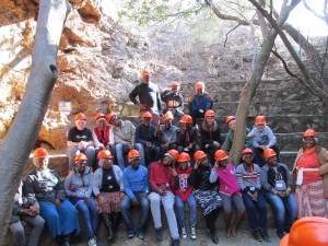
Students Visit Sterkfontein Caves

The AAG’s 2013-2014 Global Connections and Exchange My Community, Our Earth Youth TechCamps Program provided thirty competitively selected high school students from across the United States and 90 of their counterparts in Bolivia, Panama and South Africa with the opportunity to collaborate in cross-cultural teams using geospatial technologies. Three ten-day TechCamps were held in Bolivia (La Paz), South Africa (Pretoria) and Panama (Panama City and Azuero) from June to August 2014, during which participants received orientation and training in the use of geotechnologies including online mapping, community GIS, mobile GPS and crowd mapping. Students utilized these technologies and worked together on group projects in which they developed creative ways to address sustainable development issues relating to Climate Change in each of these countries. Students also participated in local cultural activities and field trips during the TechCamps, forming unforgettable memories and friendships.

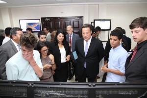
Students Present Projects to President Juan Carlos Varela

Participants from the United States maintained a daily blog for each of the TechCamps on the GCE MyCOE Wiki Page, through which they shared their experiences with friends and family back home throughout the program. At the culmination of each TechCamp, students participated in TechTorrent sessions, where each cross-cultural team presented their youth-led projects in front of audience members including government officials and U.S. embassy staff from each of these countries, students, university staff, and invited special guests. These presentations can be found on the MyCOE YouTube page.

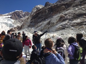
Field visits to Glacier Chacaltaya and the site of the Callapa Landslide gave students who participated in the La Paz TechCamp the opportunity to see climate change in action. In South Africa, a day in the Sterkfontein Caves near Johannesburg gave participants a new perspective on the history of humankind in Africa, while a safari tour provided everyone with a break from their hard work. Students who participated in the Panama City TechCamp visited the Panama Canal and had the opportunity to meet Panamanian President Juan Carlos Varela, who attended the TechTorrent presentations. In her blog post, one student described the TechCamps as “an experience that I, and my 9 other friends, will never forget.”

Each TechCamp was led by an instructional team of professors, specialists, and professionals in related fields. Students were supported by Dr. Patricia Solis, GCE MyCOE Program Director, Astrid Nicole Ng, Marcela Zeballos, Candida Mannozzi, Dr. Niem Huynh, Matthew Hamilton, Nekya Young and Kelsey Taylor of the Association of American Geographers.

Students on Glacier, Field Exercise at Huayna Potosi

The TechCamps were held in collaboration with the Universidad Mayor de San Andrés, EIS Africa, Afrispatial, the University of Pretoria, the Universidad Tecnológica de Panama and the Gabriel Lewis Galindo Foundation. Esri also provided access to and training in geospatial technologies for participants at all three TechCamps.

The GCE MyCOE Youth TechCamps program was implemented by the AAG with funding from the US State Department’s Bureau of Educational and Cultural Affairs Youth Division under the Global Connections and Exchange Program and under the partnership umbrella of My Community, Our Earth: Geographic Learning for Sustainable Development.

For more information on the GCE MyCOE Youth TechCamps, please visit https://www.aag.org/techcamps.

    Share

MyCOE / SERVIR Global Fellowship Program

mycoe servir capstoners-with-dr-shah_usaid1-1024x341
MyCOE SERVIR Capstone Fellows with Dr. Rajiv Shah, USAID Administrator, Washington, D.C. April 2014

MyCOE / SERVIR Global Fellowship Program: 2012-2014

The MyCOE / SERVIR Global Fellowship Program is a partnership between the AAG’s MyCOE program and the NASA SERVIR program, a collaborative venture among the NASA Earth Science Division Applied Sciences Program, USAID, and worldwide partner institutions, to help university students living and studying in developing regions conduct long-term research or educational activities in response to sustainable development needs in their countries. The 2012-2014 fellowship program provided 120 university undergraduate and graduate students training in geographic in geographic technologies for sustainable development. Four regional rounds of the fellowship program were conducted in East Africa, Himalayas, West Africa and Southeast Asia.  Each round centered around a 10-day launch workshop led by an instructional team of professors, specialists, and professionals in relevant fields. MyCOE Program Director Dr. Patricia Solis, Marcela Zeballos, Astrid Ng, Matthew Hamilton, and Candida Mannozzi of the Association of American Geographers provided on and off-site support to student-mentor teams during each workshop and for the length of the fellowship program.

The workshops were held in collaboration with the Regional Center for Mapping of Resources for Development (RCMRD) headquartered in Nairobi, Kenya; the International Centre for Integrated Mountain Development (ICIMOD) in Kathmandu, Nepal; the Center for Remote Sensing and Geographic Information Services (CERSGIS) in Accra, Ghana; and USAID’s Regional Development Mission for Asia (RDMA) in Bangkok, Thailand.  Students received technical training, fieldwork methods and professional development sessions. Following the workshop, fellows spent 3-6 months conducting necessary research and later implementing the outreach component of their projects to share their results with local stakeholders.

The MyCOE / SERVIR Capstone Event, which took place April 3-12, 2014, celebrated the global program carried out over the past two years with representation from outstanding program fellows selected to showcase the work they accomplished during the MyCOE / SERVIR Global Fellowship Program. The 14 capstone fellows presented to officials at USAID and NASA Headquarters in Washington, D.C., appeared live on NASA TV, visited Goddard Space Flight Center and presented their work at a featured illustrated paper session during the AAG’s Annual Meeting in Tampa, Florida.  See Capstone Fellows testimonials following their presentations at NASA and USAID by visiting the SERVIR Global Youtube Site.

Participants received a modest research stipend, travel support, instruction during workshops, mentoring and access to data and other resources to improve projects. They also received geographic data and SERVIR resources to help them conduct their three- to six-month long projects. Over the life of the fellowship, fellows had the opportunity to interact and exchange ideas with approximately 60 other teams from around the world that were selected through MyCOE / SERVIR global initiatives.

The program succeeded in fostering communication among student researchers from different countries, increasing promotion of women in science and innovation, building long-term capacity in developing regions using Geography/ GIS for sustainable development goals and raising the awareness of Geography/GIS contributions toward climate change issues.

For more information about the MyCOE / SERVIR Fellowship program, please visit https://www.aag.org/mycoe.servir.

    Share

AAG Welcomes New IT Director Colleen Dougherty

The AAG is pleased to announce that Colleen Dougherty has joined the AAG staff as Information Technology Director at the association’s headquarters in Washington, D.C. Colleen has extensive experience working with nonprofit associations similar to the AAG, including American Academy of Child & Adolescent Psychiatry and the Society of the Plastics Industry. She has strong expertise with project management and database management, including iMIS and with computer hardware and software.

Colleen holds a bachelor’s of science degree with honors in Agriculture Economics and Business Management from the University of California at Davis.

    Share

Roy Wolfe

One of the pioneers in the field of tourism geography, Roy Wolfe, passed away on November 15, 2014, a few days before his 97th birthday.

Roy I. Wolfe, known as “Izzy” to his family, was born Israel Wolbromski in Poland in 1917. In 1922 the family moved to Canada where he acquired his English name. He grew up in the Kensington Market area of Toronto, where he also spent his latter years.

The Great Depression interrupted his education but he received a bachelor’s degree in Biology from McMaster University in 1940. During the Second World War he served in the Medical Corps of the Canadian Army. Then between 1945 and 1947 he headed the Visual Education Service of the Veterans’ Rehabilitation Institute within Ryerson Polytechnic Institute (now University). During this time he studied for a master’s degree in Biology at the University of Toronto including a dissertation on the variation of finger prints across different Canadian ethnic populations.

In the next phase of his life, Wolfe recognized geography as the discipline most closely aligned with his own interests. He took a position at the Department of Highways of Ontario (DHO) in 1952 where he rose through ranks as Statistician, Planner, Geographic Advisor, and Research Geographer. During this time he studied for a PhD in Geography at the University of Toronto. Initially the doctoral committee refused to approve his proposed research on summer cottages because tourism and recreation were not seen as appropriate subjects for serious scholarly research at the time. The committee relented after a year and he undertook a study of the location, ownership, and use of summer cottages in the province of Ontario, as well as their owners’ travel patterns. The doctorate was awarded in 1956.

At the DHO Wolfe made a significant contribution to economic planning and transportation policy. He was also an early adopter of mainframe computers to facilitate statistical analysis. After he was recruited into the faculty of the Geography Department at York University in 1967, he remained active as a planning consultant, participating in nearly two dozen tourism-related projects for governments in Canada, the United States and the UK.

At York University he taught courses in the regional geography of Canada, transportation geography, and recreation geography. His research continued in tourism geography, focused on the interactions between urban centers and nearby recreation areas. His numerous scholarly publications were instrumental in the creation of the new sub-field of recreation geography; he also made significant contributions to the literature on transportation and planning.

Wolfe had been profoundly deaf since 1947 but this did not hinder his love of teaching and interacting with students. He could lip read in English, as well as Yiddish, French and German. He also enlisted the aid of others to take notes for him during conversations, lectures, and presentations. This role was frequently performed by his devoted wife, Rosemary, as well as by students or colleagues.

The profound hearing loss made him value clear and elegant writing as a way to communicate effectively. He devoted long hours to editing and marking students’ essays, trying to improve their writing skills, frequently covering the page with red ink. One former student recalled that he “made the pages bleed!” He eventually compiled a seven-page guide for students called “Hints, Admonitions, and Downright Threats from a Jaded Reader of Too Many Sloppy Essays.”

Despite his high standards and formidable nature, he was much loved by students. In 1981 he was successfully nominated for the annual teaching award of the Ontario Confederation of University Faculty Associations (OCUFA). Subsequently the Canadian Association of Geographers created a teaching award in his name.

In addition to duties at York, he held visiting positions at the State University of Washington, WA, Saint Mary’s University in Halifax, NS, and Atkinson College in York, ON. He was also a member of the IGU Commissions on Transportation, and on Tourism and Recreation.

Wolfe retired in 1983 having left a substantial intellectual and personal legacy. He legitimized research on tourism in geography, undertook pioneering scholarship, and inspired many geographers in his generation. His work provided the intellectual foundation for much of the research in contemporary tourism geography, with his publications on second homes cited more in the decade prior to his death than any time previous. His work was also influential beyond tourism and geography in the fields of regional science and marketing.

In 1988, the Association of American Geographers established the annual Roy Wolfe Award in his honor which recognizes “outstanding contributions to the field and discipline of Recreation, Tourism and Sport Geography.” The award has been won by geographers from Canada, Finland, New Zealand, and the United States to date.

Roy was predeceased by his wife Rosemary and daughter Cynthia but leaves behind four children (Robert David, Richard, Judy and Mitzi), six grandchildren and two great-grandchildren.

    Share

New Books: November 2014

Every month the AAG compiles a list of newly-published books in geography and related areas. Some are selected for review in the AAG Review of Books.

Publishers are welcome to send new volumes to the Editor-in-Chief (Kent Mathewson, Editor-in-Chief, AAG Review of BooksDepartment of Geography and Anthropology, Louisiana State University, Baton Rouge, LA 70803).

Anyone interested in reviewing these or other titles should also contact the Editor-in-Chief.

November, 2014
    Share

Forrest R. Pitts

Forrest Pitts, emeritus professor of geography at the University of Hawaii, died earlier this year at his home in Santa Rosa, California.

Pitts taught for many years at the University of Oregon, University of Pittsburgh, and Seoul National University. In 1989, he retired from the University of Hawaii after 35 years of teaching and field research. His professional interests were in Asia and in computational approaches to geographic science.

After serving in the U.S. Navy during World War II and studying Japanese at the Language School in Boulder, Colorado, Pitts earned a bachelor’s degree in Oriental Languages and Literature at the University of Michigan. He continued his graduate studies in Michigan to earn a master of arts degree in Far Eastern Studies and a doctorate in Geography.

Pitts’ work is marked by fieldwork in Japan, Okinawa, and Korea. He was editor of Korean Studies, and served eight years as executive director of the International Geographical Union Commission on Quantitative Methods.

    Share

James Newman on Illinois Politics

You might say Quinn/Rauner was a squeaker, and Durbin/Oberweis was a cakewalk. Here’s why you’d be wrong.

The outlook was bleak nationwide for Democrats as the nation approached mid-term elections. Despite improvements in employment, troop drawdowns in Afghanistan, and increasing numbers of insured persons under the Affordable Care Act, the public’s confidence in the Obama Administration had sunk to record low levels. Most Democrats facing election contests sought to distance themselves from the very programs they had enthusiastically supported just a few years, or even months, earlier, eager to dissociate themselves from the President’s waning popularity. By the time Election Day rolled around, Democrats had resigned themselves to declining numbers in the House of Representatives with all of its two-year terms in contention; in the Senate, even their most optimistic hopes were for a 50-50 split (in which Vice President Joe Biden would be able to cast deciding votes), while more realistic expectations were that they would become at least a slim minority.

ELECTION NIGHT IN ILLINOIS SELDOM LACKS FOR DRAMA, AND THE 2014 MIDTERM ELECTION WAS NO EXCEPTION.

The Democrats best hopes were to hold on strong at the state level, among governorships and state legislatures. It was in this atmosphere that the party nervously eyed the State of Illinois, whose embattled Democratic governor Pat Quinn continued to be shadowed by the spectre of his predecessor, Rod Blagojevich, who had been ousted amidst a swirl of corruption charges. (Quinn had ascended to the governor’s chair in 2009 upon Blagojevich’s removal, and had eked out a narrow margin over Republican Bill Brady in the 2010 election.) Years of excessive capital spending and increases in public pension commitments had skyrocketed Illinois to a precarious financial position. In 2014 Quinn faced businessman Bruce Rauner, a highly-successful businessman in several private equity firms who had campaigned on the promise of restoring fiscal responsibility and integrity to the state.

Meanwhile, Senate Majority Whip Richard Durbin was considered to have a relatively safe course to re-election against dairy magnate Jim Oberweis, who was perceived by much of the electorate to be closely tied to the Tea Party and held extremely conservative views that were at odds with the extensive “blue” voter base in Illinois. Oberweis had failed twice before in attempts at statewide office, failing to progress past the primaries in a previous US Senate bid and the 2010 governor race. Finally gaining public office in the Illinois Senate, he leveraged that 2012 electoral success to position himself as the Republicans’ 2014 US Senate candidate. Durbin’s status as senior senator, his overall popularity among the electorate, and Chicago’s propensity to deliver massive Democratic margins were expected to propel Durbin to a relatively comfortable victory.

Election night in Illinois seldom lacks for drama, and the 2014 midterm election was no exception. While in the Senate race, challenger Jim Oberweis conceded to incumbent Dick Durbin just hours after the polls closed, incumbent governor Pat Quinn held fast to the possibility of victory, still declining to concede the race as of late Wednesday morning. It’s only reasonable to conclude that Durbin/Oberweis was a cakewalk, and Quinn/Rauner was a squeaker. Reasonable, but wrong – in fact, just the opposite can be argued. Application of geographic analytic tools sheds light on why this is true.

While Quinn had won only four counties in 2010, his vote margins were slim and he was carried to victory on the strength of the overwhelming margin in the perennial Democratic stronghold of Cook County. In 2014, within hours of poll closings, it was clear that this was not to be Quinn’s night – he had lost the downstate Democratic counties of St. Clair & Jackson, and his margin in Cook County was going to fall well short of his 2010 margin, and would not be nearly enough to eke out a victory for him this year.

An analytic tool called Rank-Mobility Index (RMI) helps to explain just how and where Quinn’s support fell apart. Sheer number of votes is not important in itself; rather, the vote margin between the candidates tells the story when viewed on a county-by-county basis. RMI reveals where Democratic vote production succeeded and fell short, and suggests how those changes manifested themselves in the final outcome.

To determine the RMI, the statistic of interest – in this case, vote margin for Quinn over Rauner – is computed for each county. To adjust for the effects of county size, this figure must be normalized to margin per 1000 persons of voting age (MpK). The counties are then ranked 1-102 based on their MpK for the 2010 election, and again for the 2014 election. RMI is then computed as (R2010‑R2014)/(R2010+R2014); the resulting value can range from ‑1.0 to +1.0. The power of the RMI is two-fold:

  • it recognizes that large changes in rank are more significant than small changes, BUT . . .
  • it also recognizes that equal changes are more significant among high ranks than among low

So, for example, in 2014, the ranks for Lake & McHenry counties were 16 and 42, respectively, while in 2010 their ranks had been 7 and 33. Both fell 9 ranks from 2010 to 2014, but Lake County’s RMI of ‑0.391 shows its shift to be more significant than McHenry’s RMI of ‑0.120.

In 2014, Cook was the only county to provide a net positive vote margin for Quinn. Thus, in Table 1, the MpK values are negative, reflecting that Quinn fell short by that number of votes for every 1000 persons of voting age. The county with the best improvement was Fulton, which in 2010 had a negative MpK of ‑35.4073; this improved to ‑6.7540 in 2014, which moved Fulton County up from 8th‑best to 2nd‑best in producing a Democratic margin. Franklin County, on the other hand, declined from ‑21.3725 MpK to ‑117.1895 MpK, dropping it from 6th-best to 43rd-best and resulting in a large negative RMI.

Charting the RMIs on the map thus provides insight into details of Quinn’s performance. The blue counties, denoting improvement in Democratic vote production, form a swath from northwest to east-central Illinois, taking in primarily rural counties with lower voter counts. Meanwhile, Cook County shows a decline in performance (while retaining the number 1 rank, its MpK fell from 126.3259 in 2010 to 98.1427 in 2014), as do the collar counties and southern counties. Significantly, the key downstate counties of St. Clair, Jackson, and Alexander all showed rather strong decreases in Democratic voter production, and indeed all turned from blue to red in the 2014 election.

Turning to the U.S. Senate race, the differences between the 2008 margins and 2014 margins are much more dramatic than the 2010-2014 changes in the governor’s race. As usual, Cook County Democrats turned out in numbers sufficient to offset downstate Republicans and tip the balance to Durbin. But the breadth and depth of the Republican margins, especially when compared to the almost-all-blue map of 2010, is certainly an attention getter. Once again, RMI helps to reveal the story within the story.

The strongest gains in Democratic vote production were in three far-southern counties – Jackson, Alexander, and Pulaski, two of which had already demonstrated a strong Democratic margin in both the 2008 Senate race and the 2010 governor’s race. Central Illinois, from Bureau & LaSalle counties in the north to Effingham & Jasper counties in the south, demonstrated a solid Republican upswing, especially in Putnam, Mason, and Macon counties. Those changes in relatively low population counties may not have been, by themselves, significant – until Democratic bastion Cook County is considered. The effectiveness of Democratic vote production in Cook actually declined relative to the other counties in the state – making it all the more important for Durbin to put in a strong showing downstate. Of the top five counties in voter production in 2008, however, three – Putnam, Gallatin, and Mason – fell to the bottom five in 2014. Lake County, recently more evenly split between the parties than most of the other collar counties, edged into the top five RMI by moving from 27th rank to 11th, but that was primarily by virtue of even worse performance by other counties, as Lake’s MpK fell from 172.8010 to 7.5804.

One last key question is this: How did the candidate perform compared to other candidates of the same party? In particular, with major statewide offices such as Governor and U.S. Senator, did one race either help or hinder the other? Using RMI to compare Democratic vote production for the governor’s race vs. the U.S. Senate race suggests that Durbin, while mostly coasting toward a fairly comfortable victory, may well have been hampered by Quinn’s unpopularity. Those counties showing improved vote production for Senate vis-à-vis all other counties are mainly clustered in the far downstate region of the state. Meanwhile, the populous counties of the north, and particularly the northeast, demonstrated a strong decline in effectiveness in vote production, Lake County being the only significant exception. Perhaps Democrats came out in stronger numbers for Quinn in light of his anticipated contest, while showing disinterest in Durbin’s expected easy cruise to victory.

The only numbers that ultimately matter, of course, are the final statewide vote tallies. But putting the power of the RMI to use helps to show that there’s a lot more to the story than revealed by the raw numbers.

Acknowledgement to Dr. Richard Greene, Department of Geography, Northern Illinois University, for contributions to the methodology included in this analysis.

James W. Newman
Department of Geography
Northern Illinois University

DOI: 10.14433/2014.0022
    Share

AAG Member Jeanette Rice Joins CBRE to Lead Research Efforts Focused on Investment in the Americas

Jeanette Rice Joins CBRE to Lead Research Efforts Focused on Investment in the Americas

CBRE Group, Inc. announced that Jeanette I. Rice has joined the company to lead its research efforts focused on the investment market in the Americas. In this role Ms. Rice will manage the investment and strategy team within CBRE’s research group, developing analysis and insight on investment opportunities across the region.

Ms. Rice, who will have the title of Americas Head of Investment Research at CBRE, has more than 30 years of experience as a senior-level economist, market analyst, and investment strategist. This includes extensive investment strategy activities, including comparative market analysis, metro market selection, submarket selection, product strategy, pricing/risk analysis, and other investment strategies for internal and client investment decisions.

“Jeanette has built a reputation for thoughtful in-depth analysis and forecasting in all major commercial property types as well as a thorough understanding of global, national and regional economic trends,” said Spencer Levy, Americas Head of Research, CBRE. “Her addition to our team complements our existing capabilities and enhances our ability to deliver sharp, insightful analysis on market trends that institutional investors increasingly require.”

Ms. Rice has consulted for investors such as Verde Realty, IDI, Brookfield Asset Management, The Lionstone Group, Granite Properties and Invesco Real Estate, and has held senior investment strategy and research leadership positions at IDI Gazeley, Crescent Real Estate and HFF.

Ms. Rice received a B.A. from the University of Washington (Seattle), an M.A. from Queen’s University (Kingston, Ontario, Canada) and did additional graduate studies at the University of Chicago. She holds the Counselor of Real Estate (CRE) designation and is RERI (Real Estate Research Institute) and Homer Hoyt Fellow. Ms. Rice is based in Dallas.

    Share

Geography and STEM

I knew that I had put my finger on something important when I sent out a message on a listserv and received multiple responses almost immediately and continuously for the next few days. As I’m sure most of us have experienced, our inboxes can fill up overnight with seemingly unimportant messages that are left unread. But clearly the title of my message – Geography and STEM — caught people’s attention. What’s even more impressive about the responses I received is that the message was being sent to chairs of geography departments, a group of people who most likely already receive tons of annoying messages from everyone wanting something. I tried to keep my email short and to the point, asking for two responses: was geography considered a STEM discipline at their institution, and in what ways did the STEM designation matter, leaving open an option of addressing ‘other’ related concerns about geography and STEM. I received over 40 responses, most at least a couple of paragraphs long. Impressive by all counts. In this column I want to review why this is such an important, ambiguous, and anxiety-inducing topic, summarize what many of my respondents said in regard to STEM, and suggest some ways to be “strategic opportunists.”

For those uninitiated or not from the United States, STEM stands for science, technology, engineering and math, fields that many academic and political leaders in the United States have assessed as important for the present and future growth of our economy, and fields in which American students are not excelling. Strengthening the teaching of STEM fields in K-12 and higher education, therefore, has been heralded as essential to our global competitiveness by key figures in American education and politics, from the President of the United States, to provosts of major research universities, to principals and superintendents of school systems. As a result, funding at all levels has been increased for STEM, often at the cost of support for other disciplines. We could certainly contest why these particular disciplines and ways of knowing the world have been singled out for attention and funding (as many, particularly in the humanities, have done) but for the sake of this short column I want to focus on the realities most of us are facing right now as we try to maneuver with and through STEM.

The status of Geography vis-à-vis STEM is ambiguous for two primary reasons. First, there is no one agreed upon national definition of what specific fields of study STEM refers to. The Department of Homeland Security includes Geographic Information Science and Cartography as a STEM discipline (this is important in terms of international student recruitment), while the National Science Foundation includes geography in its list of disciplines eligible for STEM funding for most of its graduate educational competitions. The field of Geosciences (and therefore most of physical geography) is included in both definitions. Second, geography is a broadly interdisciplinary discipline, what I referred to in my first column as radically intra-disciplinary. Prodded by the AAG, the National Research Council now includes four subfields within Geography and Regional Science, two of which (Physical and Environmental Geography, Geographic Information Science) are clearly STEM fields by all counts (the other two are Human and Cultural Geography and Nature and Society Relations). And according to a study completed in 2005, 28 percent of all geography faculty teaching in graduate programs identify with one of those two STEM fields. More recently, a study of the types of degrees offered by geography bachelor and masters programs in the United States found that more than 50 percent of those programs offered a BS/MS with emphases on Physical Geography and/or Geographical Information Sciences.[1] Given the ambiguity caused by geography’s intra-disciplinarity and the lack of one agreed upon definition of STEM, and because so much is at stake, there is indeed cause for anxiety.

And that ambiguity and latent anxiety is reflected in my not scientific (and therefore not STEM!) but very informative survey of geography department chairs. The responses to the first question were almost evenly divided between those whose universities had deemed geography a STEM discipline, those that had not, and those that had split the difference (some courses considered STEM, some not). One of the more interesting insights from the responses that I received is that some of the designations had clearly hinged on the school/college that housed geography: whether a college of science or a college of liberal arts/social sciences. Some geography departments that had merged with (or re-branded themselves, see Julie Winkler’s recent column) departments of geosciences, for example, were then clearly placed within schools/colleges of science and considered STEM. Most illuminating, of course, were the responses to my second query: in what ways did this designation matter. The two primary responses were in regard to funding and student enrollment. And again my responses were almost evenly split between those departments that were experiencing increases in funding and enrollment because geography was considered STEM, and those that were just the opposite.

The most passionate responses came from two sources. Departments that were not in any way included in STEM are experiencing declines in student enrollment, particularly in their physical geography and geospatial courses. Without STEM designation, these courses are sort of “remaindered,” left only to fulfill major requirements. On the other hand (and the other source of passionate responses) departments that are STEM-designated are losing enrollment/status in their human/cultural geography courses, again left as “remainders” for major credit only. I suspect these responses were most passionate and anxiety-riddled because they are about hierarchies, the prioritization of one part of geography over another. This perhaps is the most pernicious aspect of STEM initiatives: the risk that geography is pulled apart and that we become less than the sum of our parts, instead of more than. We can ill afford to do that.

So, what to do? I received quite a few responses from department chairs who were able to take STEM initiatives and put them to geography’s advantage. Montana State University, for example, has used NSF funding focused on supporting women in STEM to hire three new faculty members, two of whom do integrative human/physical, qualitative/quantitative research; in other words, geography. Other departments are making sure that university administrators understand that geography is intra-disciplinary, that it houses STEM and non-STEM courses and ways of understanding the world, and that putting those two together is productive intellectually and practically. In my first column I used the term strategic essentialism; here I want to introduce a related term, strategic opportunism. We cannot afford to let STEM pass us by, but we need to pursue the opportunities it affords us strategically, in a thoughtful, forward-thinking way that promotes what is best about geography as a whole and that does not prioritize one way of understanding the world over another. I look forward to hearing your thoughts about this important matter, and to learning about how different geographers and departments have maneuvered in this ambiguous and anxious world of strategic opportunities.

[1] See Rajibul Al Mamun, Does the Geography Major Fit in STEM?, Journal of Geography and Geology, 2015. DOI: 10.5539/jgg.v7n1p27.

— Mona Domosh

DOI: 10.14433/2014.0021

    Share

New Books: October 2014

Every month the AAG compiles a list of newly-published books in geography and related areas. Some are selected for review in the AAG Review of Books.

Publishers are welcome to send new volumes to the Editor-in-Chief (Kent Mathewson, Editor-in-Chief, AAG Review of BooksDepartment of Geography and Anthropology, Louisiana State University, Baton Rouge, LA 70803). Authors interested in reviewing books should also contact the Editor-in-Chief ([email protected]).

October, 2014
    Share