Member Profile: Tim Fullman

Map showing Arctic Refuge Birds-Eye-View program area created by Marty Schnure

The twice-annual migration of Alaska’s caribou is one of the world’s great journeys. Yet the number of caribou making that trek has been declining for decades due to a variety of factors, including habitat disruption from human activities and a changing environment.
Photo of Tim FullmanGeographer Tim Fullman, senior ecologist with The Wilderness Society, is one of the people working to understand how to conserve the critical habitat on which caribou rely. Using analyses drawn from spatial and interdisciplinary sources, Fullman tracks and predicts herd patterns as they move over Alaska’s public lands. Much of his research focuses on the Western Arctic Caribou Herd (WACH), among the biggest of the state’s 32 caribou herds.
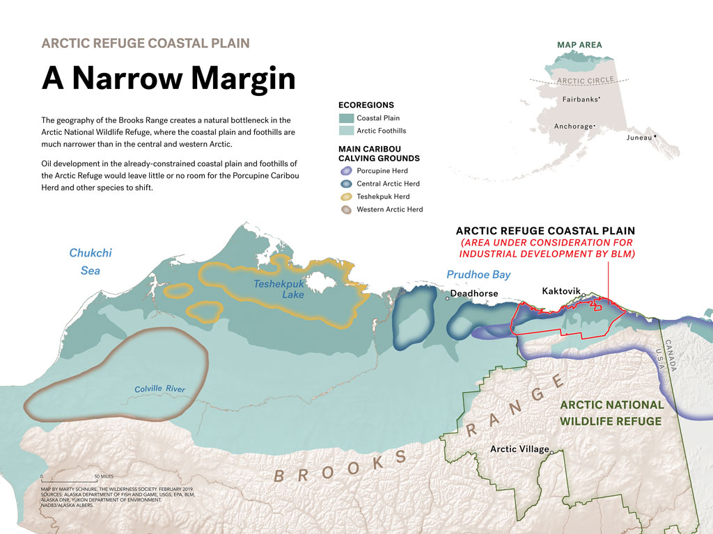
Arctic Refuge Coastal Plain: A Narrow Margin The geography of the Brooks Range creates a natural bottleneck in the Arctic National Wildlife Refuge, where the coastal plain and foothills are much narrower than in the central and western Arctic. Oil development in the already-constrained coastal plain and foothills of the Arctic Refuge would leave little or no room for the Porcupine Caribou Herd and other species to shift.
Arctic Refuge Coastal Plain: A Narrow Margin: The geography of the Brooks Range creates a natural bottleneck in the Arctic National Wildlife Refuge, where the coastal plain and foothills are much narrower than in the central and western Arctic. Oil development in the already-constrained coastal plain and foothills of the Arctic Refuge would leave little or no room for the Porcupine Caribou Herd and other species to shift. Map created by Marty Schnure


Fullman works alongside many partners, from Indigenous community leaders to hunters to tour guides to local, state, and federal wildlife and land professionals. All share a common cause: to preserve the future of Alaska’s caribou in the face of potential impacts from construction projects, energy investments, and climate change. The stakes are high. Alaska’s caribou, once totaling over a million, number 750,000 altogether today. The WACH, alone, has declined by as much as 50 percent since 2004.

In his work, Fullman spends a lot of his time using predictive models, forecasting potential impacts and scenarios that he says are also intimately connected to what we know about now and the past. “To do effective conservation means understanding the past so that we know why things are the way they are now,” he says, “and then using that information now to change the course of the future.”

Geography: The Critical Lens

Starting his career as a wildlife biologist, Fullman discovered that his fieldwork would benefit from an advanced understanding of terrain, place, and migrations. After completing a PhD in geography at the University of Florida, he returned to his work studying large herbivores, this time in Alaska. (Previous research had taken him to southern Africa, where he studied elephants).

Now, he says, his geography expertise takes people by surprise. “In my professional role, I don’t think many people know that I am a geographer, because my title is senior ecologist, and people think of me doing wildlife work,” he says. “Yet I’ve been fascinated as I’ve interacted with more people to come across a number of people with geography backgrounds who are doing work in landscape, ecology, environmental policy, and similar work.”

Why are so many geographers drawn to conservation—or rather, why are many conservationists drawn to geography? “This training seems like it has prepared a number of us to be able to make connections and share, and especially to use maps and other representations to talk about and communicate things in ways that connect with people.”

Geography’s interdisciplinary nature is also a plus: “One of the things that has helped me is that my geography department did not focus a lot on wildlife, but I had colleagues doing human dynamics, economic geography, all sorts of things that fall under the umbrella of geography. I think that prepared me to understand how social science is done, to understand how economics is done, and yet to see the connections where spatial processes and things that happen at space and scale and time influence across all these areas. I think of that as being at the core of geography and what we do.”
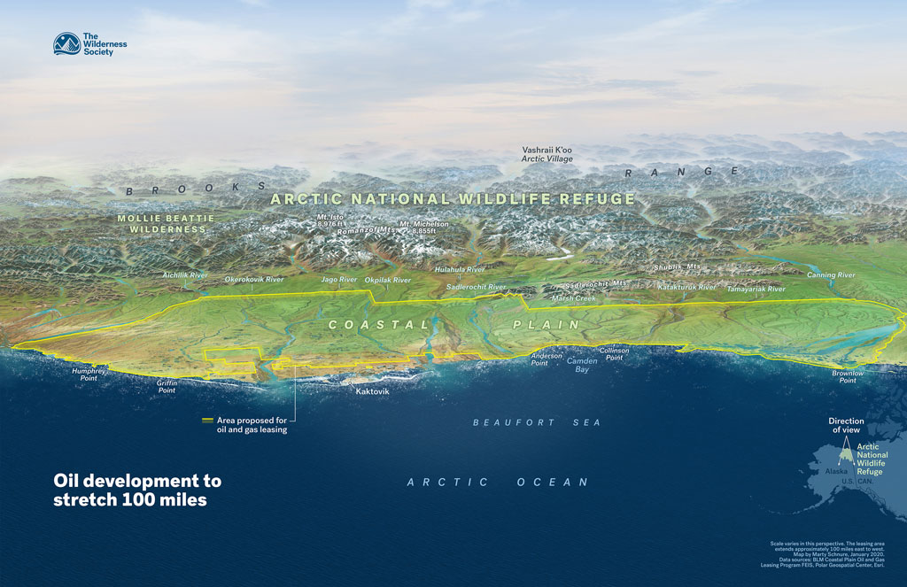
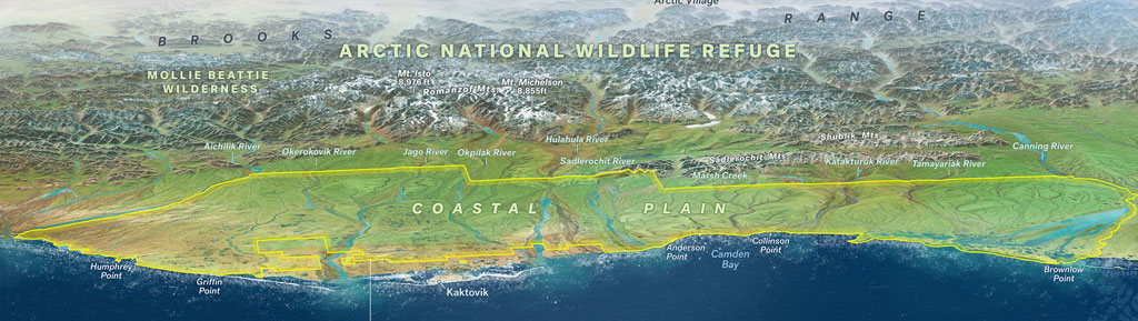
Birds-eye view of the Arctic National Wildlife Refuge coastal plain, known as the 1002 Area, outlined in yellow. This area, which is a critical calving and post-calving habitat for the Porcupine Caribou Herd, was leased by the Bureau of Land Management for its oil and gas program during the Trump Administration. Map created by Marty Schnure


Fullman applies ideas and methods from other disciplines to aid in his modeling work. One of these is circuit theory, adapted by ecologists from the world of electronics, which recently helped Fullman and his colleagues model the impacts of road construction on caribou and other species’ habitat. Another tool is the Monte Carlo simulation, used by Fullman and other researchers to test development restriction scenarios for the National Petroleum Reserve-Alaska (NPR-A): four from the Bureau of Land Management’s current Integrated Activity Plan, and one put forward by the Western Arctic Caribou Herd Working Group, to which Fullman belongs.

Map showing caribou seasonal ranges and proposed development projects created by Marty Schnure
Map showing caribou seasonal ranges and proposed development projects, created by Marty Schnure


Fullman’s training as a geographer has helped him embrace the many perspectives and complex realities of Alaskan habitats. In studying the ancient presence and fragile present of the caribou, he recognizes the long lineage and millennia-old knowledge held by the Indigenous communities within and around the NPR-A. As he brings new tools to the study of the herds, he embraces opportunities to learn and follow traditional ecological knowledge. “I am very classically trained as a scientist but yet through my time in Alaska, it has stretched my view,” he says. “What does it look like to meaningfully combine and blend all the ways of seeing the caribou?”

“Caribou Tell Us a Little Bit About Ourselves”

Fullman’s work contributes to understanding the pressure on caribou, which is part of a much larger and concerning trend of long-range and major migrations of all species—and humans.

“Caribou tell us a little bit about ourselves. They face some of the same challenges we do: warming climate, increasing development, and changing habitat – but with arctic temperatures increasing at double the rate of the rest of the planet, they’re feeling these challenges first,” says Fullman.

“Are we willing in any place to curb our desire to develop?” he asks “There are some places that are too important and too special.”

Find out more about AAG’s work to address climate change
    Share

Member Profile: Lesley-Ann Dupigny-Giroux

Map showing Arctic Refuge Birds-Eye-View program area created by Marty Schnure

The twice-annual migration of Alaska’s caribou is one of the world’s great journeys. Yet the number of caribou making that trek has been declining for decades due to a variety of factors, including habitat disruption from human activities and a changing environment.

Photo of Tim FullmanGeographer Tim Fullman, senior ecologist with The Wilderness Society, is one of the people working to understand how to conserve the critical habitat on which caribou rely. Using analyses drawn from spatial and interdisciplinary sources, Fullman tracks and predicts herd patterns as they move over Alaska’s public lands. Much of his research focuses on the Western Arctic Caribou Herd (WACH), among the biggest of the state’s 32 caribou herds.

Arctic Refuge Coastal Plain: A Narrow Margin The geography of the Brooks Range creates a natural bottleneck in the Arctic National Wildlife Refuge, where the coastal plain and foothills are much narrower than in the central and western Arctic. Oil development in the already-constrained coastal plain and foothills of the Arctic Refuge would leave little or no room for the Porcupine Caribou Herd and other species to shift.
Arctic Refuge Coastal Plain: A Narrow Margin: The geography of the Brooks Range creates a natural bottleneck in the Arctic National Wildlife Refuge, where the coastal plain and foothills are much narrower than in the central and western Arctic. Oil development in the already-constrained coastal plain and foothills of the Arctic Refuge would leave little or no room for the Porcupine Caribou Herd and other species to shift. Map created by Marty Schnure


Fullman works alongside many partners, from Indigenous community leaders to hunters to tour guides to local, state, and federal wildlife and land professionals. All share a common cause: to preserve the future of Alaska’s caribou in the face of potential impacts from construction projects, energy investments, and climate change. The stakes are high. Alaska’s caribou, once totaling over a million, number 750,000 altogether today. The WACH, alone, has declined by as much as 50 percent since 2004.

In his work, Fullman spends a lot of his time using predictive models, forecasting potential impacts and scenarios that he says are also intimately connected to what we know about now and the past. “To do effective conservation means understanding the past so that we know why things are the way they are now,” he says, “and then using that information now to change the course of the future.”

Geography: The Critical Lens

Starting his career as a wildlife biologist, Fullman discovered that his fieldwork would benefit from an advanced understanding of terrain, place, and migrations. After completing a PhD in geography at the University of Florida, he returned to his work studying large herbivores, this time in Alaska. (Previous research had taken him to southern Africa, where he studied elephants).

Now, he says, his geography expertise takes people by surprise. “In my professional role, I don’t think many people know that I am a geographer, because my title is senior ecologist, and people think of me doing wildlife work,” he says. “Yet I’ve been fascinated as I’ve interacted with more people to come across a number of people with geography backgrounds who are doing work in landscape, ecology, environmental policy, and similar work.”

Why are so many geographers drawn to conservation—or rather, why are many conservationists drawn to geography? “This training seems like it has prepared a number of us to be able to make connections and share, and especially to use maps and other representations to talk about and communicate things in ways that connect with people.”

Geography’s interdisciplinary nature is also a plus: “One of the things that has helped me is that my geography department did not focus a lot on wildlife, but I had colleagues doing human dynamics, economic geography, all sorts of things that fall under the umbrella of geography. I think that prepared me to understand how social science is done, to understand how economics is done, and yet to see the connections where spatial processes and things that happen at space and scale and time influence across all these areas. I think of that as being at the core of geography and what we do.”

Birds-eye view of the Arctic National Wildlife Refuge coastal plain, known as the 1002 Area, outlined in yellow. This area, which is a critical calving and post-calving habitat for the Porcupine Caribou Herd, was leased by the Bureau of Land Management for its oil and gas program during the Trump Administration. Map created by Marty Schnure


Fullman applies ideas and methods from other disciplines to aid in his modeling work. One of these is circuit theory, adapted by ecologists from the world of electronics, which recently helped Fullman and his colleagues model the impacts of road construction on caribou and other species’ habitat. Another tool is the Monte Carlo simulation, used by Fullman and other researchers to test development restriction scenarios for the National Petroleum Reserve-Alaska (NPR-A): four from the Bureau of Land Management’s current Integrated Activity Plan, and one put forward by the Western Arctic Caribou Herd Working Group, to which Fullman belongs.

Map showing caribou seasonal ranges and proposed development projects created by Marty Schnure
Map showing caribou seasonal ranges and proposed development projects, created by Marty Schnure


Fullman’s training as a geographer has helped him embrace the many perspectives and complex realities of Alaskan habitats. In studying the ancient presence and fragile present of the caribou, he recognizes the long lineage and millennia-old knowledge held by the Indigenous communities within and around the NPR-A. As he brings new tools to the study of the herds, he embraces opportunities to learn and follow traditional ecological knowledge. “I am very classically trained as a scientist but yet through my time in Alaska, it has stretched my view,” he says. “What does it look like to meaningfully combine and blend all the ways of seeing the caribou?”

“Caribou Tell Us a Little Bit About Ourselves”

Fullman’s work contributes to understanding the pressure on caribou, which is part of a much larger and concerning trend of long-range and major migrations of all species—and humans.

“Caribou tell us a little bit about ourselves. They face some of the same challenges we do: warming climate, increasing development, and changing habitat – but with arctic temperatures increasing at double the rate of the rest of the planet, they’re feeling these challenges first,” says Fullman.

“Are we willing in any place to curb our desire to develop?” he asks “There are some places that are too important and too special.”

Find out more about AAG’s work to address climate change
    Share

Wayfinding: Finding Heat Vulnerability Before It’s Too Late

Map showing Arctic Refuge Birds-Eye-View program area created by Marty Schnure

The twice-annual migration of Alaska’s caribou is one of the world’s great journeys. Yet the number of caribou making that trek has been declining for decades due to a variety of factors, including habitat disruption from human activities and a changing environment.

Photo of Tim FullmanGeographer Tim Fullman, senior ecologist with The Wilderness Society, is one of the people working to understand how to conserve the critical habitat on which caribou rely. Using analyses drawn from spatial and interdisciplinary sources, Fullman tracks and predicts herd patterns as they move over Alaska’s public lands. Much of his research focuses on the Western Arctic Caribou Herd (WACH), among the biggest of the state’s 32 caribou herds.

Arctic Refuge Coastal Plain: A Narrow Margin The geography of the Brooks Range creates a natural bottleneck in the Arctic National Wildlife Refuge, where the coastal plain and foothills are much narrower than in the central and western Arctic. Oil development in the already-constrained coastal plain and foothills of the Arctic Refuge would leave little or no room for the Porcupine Caribou Herd and other species to shift.
Arctic Refuge Coastal Plain: A Narrow Margin: The geography of the Brooks Range creates a natural bottleneck in the Arctic National Wildlife Refuge, where the coastal plain and foothills are much narrower than in the central and western Arctic. Oil development in the already-constrained coastal plain and foothills of the Arctic Refuge would leave little or no room for the Porcupine Caribou Herd and other species to shift. Map created by Marty Schnure


Fullman works alongside many partners, from Indigenous community leaders to hunters to tour guides to local, state, and federal wildlife and land professionals. All share a common cause: to preserve the future of Alaska’s caribou in the face of potential impacts from construction projects, energy investments, and climate change. The stakes are high. Alaska’s caribou, once totaling over a million, number 750,000 altogether today. The WACH, alone, has declined by as much as 50 percent since 2004.

In his work, Fullman spends a lot of his time using predictive models, forecasting potential impacts and scenarios that he says are also intimately connected to what we know about now and the past. “To do effective conservation means understanding the past so that we know why things are the way they are now,” he says, “and then using that information now to change the course of the future.”

Geography: The Critical Lens

Starting his career as a wildlife biologist, Fullman discovered that his fieldwork would benefit from an advanced understanding of terrain, place, and migrations. After completing a PhD in geography at the University of Florida, he returned to his work studying large herbivores, this time in Alaska. (Previous research had taken him to southern Africa, where he studied elephants).

Now, he says, his geography expertise takes people by surprise. “In my professional role, I don’t think many people know that I am a geographer, because my title is senior ecologist, and people think of me doing wildlife work,” he says. “Yet I’ve been fascinated as I’ve interacted with more people to come across a number of people with geography backgrounds who are doing work in landscape, ecology, environmental policy, and similar work.”

Why are so many geographers drawn to conservation—or rather, why are many conservationists drawn to geography? “This training seems like it has prepared a number of us to be able to make connections and share, and especially to use maps and other representations to talk about and communicate things in ways that connect with people.”

Geography’s interdisciplinary nature is also a plus: “One of the things that has helped me is that my geography department did not focus a lot on wildlife, but I had colleagues doing human dynamics, economic geography, all sorts of things that fall under the umbrella of geography. I think that prepared me to understand how social science is done, to understand how economics is done, and yet to see the connections where spatial processes and things that happen at space and scale and time influence across all these areas. I think of that as being at the core of geography and what we do.”

Birds-eye view of the Arctic National Wildlife Refuge coastal plain, known as the 1002 Area, outlined in yellow. This area, which is a critical calving and post-calving habitat for the Porcupine Caribou Herd, was leased by the Bureau of Land Management for its oil and gas program during the Trump Administration. Map created by Marty Schnure


Fullman applies ideas and methods from other disciplines to aid in his modeling work. One of these is circuit theory, adapted by ecologists from the world of electronics, which recently helped Fullman and his colleagues model the impacts of road construction on caribou and other species’ habitat. Another tool is the Monte Carlo simulation, used by Fullman and other researchers to test development restriction scenarios for the National Petroleum Reserve-Alaska (NPR-A): four from the Bureau of Land Management’s current Integrated Activity Plan, and one put forward by the Western Arctic Caribou Herd Working Group, to which Fullman belongs.

Map showing caribou seasonal ranges and proposed development projects created by Marty Schnure
Map showing caribou seasonal ranges and proposed development projects, created by Marty Schnure


Fullman’s training as a geographer has helped him embrace the many perspectives and complex realities of Alaskan habitats. In studying the ancient presence and fragile present of the caribou, he recognizes the long lineage and millennia-old knowledge held by the Indigenous communities within and around the NPR-A. As he brings new tools to the study of the herds, he embraces opportunities to learn and follow traditional ecological knowledge. “I am very classically trained as a scientist but yet through my time in Alaska, it has stretched my view,” he says. “What does it look like to meaningfully combine and blend all the ways of seeing the caribou?”

“Caribou Tell Us a Little Bit About Ourselves”

Fullman’s work contributes to understanding the pressure on caribou, which is part of a much larger and concerning trend of long-range and major migrations of all species—and humans.

“Caribou tell us a little bit about ourselves. They face some of the same challenges we do: warming climate, increasing development, and changing habitat – but with arctic temperatures increasing at double the rate of the rest of the planet, they’re feeling these challenges first,” says Fullman.

“Are we willing in any place to curb our desire to develop?” he asks “There are some places that are too important and too special.”

Find out more about AAG’s work to address climate change
    Share

Translating Geography Degrees into Environmental, Conservation, and Sustainability Work

Wayfinding: Young Geographers Unearth Clue to Climate Change in the Andes

Map showing Arctic Refuge Birds-Eye-View program area created by Marty Schnure

The twice-annual migration of Alaska’s caribou is one of the world’s great journeys. Yet the number of caribou making that trek has been declining for decades due to a variety of factors, including habitat disruption from human activities and a changing environment.

Photo of Tim FullmanGeographer Tim Fullman, senior ecologist with The Wilderness Society, is one of the people working to understand how to conserve the critical habitat on which caribou rely. Using analyses drawn from spatial and interdisciplinary sources, Fullman tracks and predicts herd patterns as they move over Alaska’s public lands. Much of his research focuses on the Western Arctic Caribou Herd (WACH), among the biggest of the state’s 32 caribou herds.

Arctic Refuge Coastal Plain: A Narrow Margin The geography of the Brooks Range creates a natural bottleneck in the Arctic National Wildlife Refuge, where the coastal plain and foothills are much narrower than in the central and western Arctic. Oil development in the already-constrained coastal plain and foothills of the Arctic Refuge would leave little or no room for the Porcupine Caribou Herd and other species to shift.
Arctic Refuge Coastal Plain: A Narrow Margin: The geography of the Brooks Range creates a natural bottleneck in the Arctic National Wildlife Refuge, where the coastal plain and foothills are much narrower than in the central and western Arctic. Oil development in the already-constrained coastal plain and foothills of the Arctic Refuge would leave little or no room for the Porcupine Caribou Herd and other species to shift. Map created by Marty Schnure


Fullman works alongside many partners, from Indigenous community leaders to hunters to tour guides to local, state, and federal wildlife and land professionals. All share a common cause: to preserve the future of Alaska’s caribou in the face of potential impacts from construction projects, energy investments, and climate change. The stakes are high. Alaska’s caribou, once totaling over a million, number 750,000 altogether today. The WACH, alone, has declined by as much as 50 percent since 2004.

In his work, Fullman spends a lot of his time using predictive models, forecasting potential impacts and scenarios that he says are also intimately connected to what we know about now and the past. “To do effective conservation means understanding the past so that we know why things are the way they are now,” he says, “and then using that information now to change the course of the future.”

Geography: The Critical Lens

Starting his career as a wildlife biologist, Fullman discovered that his fieldwork would benefit from an advanced understanding of terrain, place, and migrations. After completing a PhD in geography at the University of Florida, he returned to his work studying large herbivores, this time in Alaska. (Previous research had taken him to southern Africa, where he studied elephants).

Now, he says, his geography expertise takes people by surprise. “In my professional role, I don’t think many people know that I am a geographer, because my title is senior ecologist, and people think of me doing wildlife work,” he says. “Yet I’ve been fascinated as I’ve interacted with more people to come across a number of people with geography backgrounds who are doing work in landscape, ecology, environmental policy, and similar work.”

Why are so many geographers drawn to conservation—or rather, why are many conservationists drawn to geography? “This training seems like it has prepared a number of us to be able to make connections and share, and especially to use maps and other representations to talk about and communicate things in ways that connect with people.”

Geography’s interdisciplinary nature is also a plus: “One of the things that has helped me is that my geography department did not focus a lot on wildlife, but I had colleagues doing human dynamics, economic geography, all sorts of things that fall under the umbrella of geography. I think that prepared me to understand how social science is done, to understand how economics is done, and yet to see the connections where spatial processes and things that happen at space and scale and time influence across all these areas. I think of that as being at the core of geography and what we do.”

Birds-eye view of the Arctic National Wildlife Refuge coastal plain, known as the 1002 Area, outlined in yellow. This area, which is a critical calving and post-calving habitat for the Porcupine Caribou Herd, was leased by the Bureau of Land Management for its oil and gas program during the Trump Administration. Map created by Marty Schnure


Fullman applies ideas and methods from other disciplines to aid in his modeling work. One of these is circuit theory, adapted by ecologists from the world of electronics, which recently helped Fullman and his colleagues model the impacts of road construction on caribou and other species’ habitat. Another tool is the Monte Carlo simulation, used by Fullman and other researchers to test development restriction scenarios for the National Petroleum Reserve-Alaska (NPR-A): four from the Bureau of Land Management’s current Integrated Activity Plan, and one put forward by the Western Arctic Caribou Herd Working Group, to which Fullman belongs.

Map showing caribou seasonal ranges and proposed development projects created by Marty Schnure
Map showing caribou seasonal ranges and proposed development projects, created by Marty Schnure


Fullman’s training as a geographer has helped him embrace the many perspectives and complex realities of Alaskan habitats. In studying the ancient presence and fragile present of the caribou, he recognizes the long lineage and millennia-old knowledge held by the Indigenous communities within and around the NPR-A. As he brings new tools to the study of the herds, he embraces opportunities to learn and follow traditional ecological knowledge. “I am very classically trained as a scientist but yet through my time in Alaska, it has stretched my view,” he says. “What does it look like to meaningfully combine and blend all the ways of seeing the caribou?”

“Caribou Tell Us a Little Bit About Ourselves”

Fullman’s work contributes to understanding the pressure on caribou, which is part of a much larger and concerning trend of long-range and major migrations of all species—and humans.

“Caribou tell us a little bit about ourselves. They face some of the same challenges we do: warming climate, increasing development, and changing habitat – but with arctic temperatures increasing at double the rate of the rest of the planet, they’re feeling these challenges first,” says Fullman.

“Are we willing in any place to curb our desire to develop?” he asks “There are some places that are too important and too special.”

Find out more about AAG’s work to address climate change
    Share

Wayfinding: In the Philippines, Local Knowledge Makes a Global Impact

Map showing Arctic Refuge Birds-Eye-View program area created by Marty Schnure

The twice-annual migration of Alaska’s caribou is one of the world’s great journeys. Yet the number of caribou making that trek has been declining for decades due to a variety of factors, including habitat disruption from human activities and a changing environment.

Photo of Tim FullmanGeographer Tim Fullman, senior ecologist with The Wilderness Society, is one of the people working to understand how to conserve the critical habitat on which caribou rely. Using analyses drawn from spatial and interdisciplinary sources, Fullman tracks and predicts herd patterns as they move over Alaska’s public lands. Much of his research focuses on the Western Arctic Caribou Herd (WACH), among the biggest of the state’s 32 caribou herds.

Arctic Refuge Coastal Plain: A Narrow Margin The geography of the Brooks Range creates a natural bottleneck in the Arctic National Wildlife Refuge, where the coastal plain and foothills are much narrower than in the central and western Arctic. Oil development in the already-constrained coastal plain and foothills of the Arctic Refuge would leave little or no room for the Porcupine Caribou Herd and other species to shift.
Arctic Refuge Coastal Plain: A Narrow Margin: The geography of the Brooks Range creates a natural bottleneck in the Arctic National Wildlife Refuge, where the coastal plain and foothills are much narrower than in the central and western Arctic. Oil development in the already-constrained coastal plain and foothills of the Arctic Refuge would leave little or no room for the Porcupine Caribou Herd and other species to shift. Map created by Marty Schnure


Fullman works alongside many partners, from Indigenous community leaders to hunters to tour guides to local, state, and federal wildlife and land professionals. All share a common cause: to preserve the future of Alaska’s caribou in the face of potential impacts from construction projects, energy investments, and climate change. The stakes are high. Alaska’s caribou, once totaling over a million, number 750,000 altogether today. The WACH, alone, has declined by as much as 50 percent since 2004.

In his work, Fullman spends a lot of his time using predictive models, forecasting potential impacts and scenarios that he says are also intimately connected to what we know about now and the past. “To do effective conservation means understanding the past so that we know why things are the way they are now,” he says, “and then using that information now to change the course of the future.”

Geography: The Critical Lens

Starting his career as a wildlife biologist, Fullman discovered that his fieldwork would benefit from an advanced understanding of terrain, place, and migrations. After completing a PhD in geography at the University of Florida, he returned to his work studying large herbivores, this time in Alaska. (Previous research had taken him to southern Africa, where he studied elephants).

Now, he says, his geography expertise takes people by surprise. “In my professional role, I don’t think many people know that I am a geographer, because my title is senior ecologist, and people think of me doing wildlife work,” he says. “Yet I’ve been fascinated as I’ve interacted with more people to come across a number of people with geography backgrounds who are doing work in landscape, ecology, environmental policy, and similar work.”

Why are so many geographers drawn to conservation—or rather, why are many conservationists drawn to geography? “This training seems like it has prepared a number of us to be able to make connections and share, and especially to use maps and other representations to talk about and communicate things in ways that connect with people.”

Geography’s interdisciplinary nature is also a plus: “One of the things that has helped me is that my geography department did not focus a lot on wildlife, but I had colleagues doing human dynamics, economic geography, all sorts of things that fall under the umbrella of geography. I think that prepared me to understand how social science is done, to understand how economics is done, and yet to see the connections where spatial processes and things that happen at space and scale and time influence across all these areas. I think of that as being at the core of geography and what we do.”

Birds-eye view of the Arctic National Wildlife Refuge coastal plain, known as the 1002 Area, outlined in yellow. This area, which is a critical calving and post-calving habitat for the Porcupine Caribou Herd, was leased by the Bureau of Land Management for its oil and gas program during the Trump Administration. Map created by Marty Schnure


Fullman applies ideas and methods from other disciplines to aid in his modeling work. One of these is circuit theory, adapted by ecologists from the world of electronics, which recently helped Fullman and his colleagues model the impacts of road construction on caribou and other species’ habitat. Another tool is the Monte Carlo simulation, used by Fullman and other researchers to test development restriction scenarios for the National Petroleum Reserve-Alaska (NPR-A): four from the Bureau of Land Management’s current Integrated Activity Plan, and one put forward by the Western Arctic Caribou Herd Working Group, to which Fullman belongs.

Map showing caribou seasonal ranges and proposed development projects created by Marty Schnure
Map showing caribou seasonal ranges and proposed development projects, created by Marty Schnure


Fullman’s training as a geographer has helped him embrace the many perspectives and complex realities of Alaskan habitats. In studying the ancient presence and fragile present of the caribou, he recognizes the long lineage and millennia-old knowledge held by the Indigenous communities within and around the NPR-A. As he brings new tools to the study of the herds, he embraces opportunities to learn and follow traditional ecological knowledge. “I am very classically trained as a scientist but yet through my time in Alaska, it has stretched my view,” he says. “What does it look like to meaningfully combine and blend all the ways of seeing the caribou?”

“Caribou Tell Us a Little Bit About Ourselves”

Fullman’s work contributes to understanding the pressure on caribou, which is part of a much larger and concerning trend of long-range and major migrations of all species—and humans.

“Caribou tell us a little bit about ourselves. They face some of the same challenges we do: warming climate, increasing development, and changing habitat – but with arctic temperatures increasing at double the rate of the rest of the planet, they’re feeling these challenges first,” says Fullman.

“Are we willing in any place to curb our desire to develop?” he asks “There are some places that are too important and too special.”

Find out more about AAG’s work to address climate change
    Share

On the Map: The Wry Smile of Sable Island

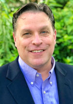
Picture of Sable Island in an atlas.

When you next find yourself moving your eyes or navigating a finger across a map of the Northwest Atlantic, you may be in for a surprise. About 175 km southeast of Nova Scotia, a seam appears on the surface of the ocean and opens up, ever-so-slightly, into a wry smile. 

An adjacent label should offer a name: Sable Island.


Sable Island pictured in an atlas in isolation.


Really? Can we be sure about this? The island is an anomaly, way out in the Atlantic, and there is nothing nearby that seems to justify its existence, geologically speaking. So it’s hard not to wonder about its position on the map, and its presence in the physical world. 

It is tempting to imagine that the island’s unusually graceful outline might indicate the presence of a clever cartographer — one who has inserted a fictitious landmass in the Atlantic to suss out copycat mapmakers. There are precedents for such behavior on land after all: Ever heard of a “trap street”?

But a quick internet search confirms that Sable Island does exist. It is a place of sand, wind, waves, a single Scots pine (the only survivor of more than 80,000 trees planted since 1900), and feral horses, among other things. 

Map of Sable Island
Map of Sable Island.


Looking closer, Sable Island yields quirks far better than any tricky mapmaker could. For starters, it looks like a barrier island but is located much further from the coastline than typical barrier islands. It likely formed from a terminal moraine — a mass of rocks and sediment carried down and deposited by a glacier, — sometime during the last Ice Age. That origin story may also help to explain the unexpected stability of some of the island’s dune structures. 

Over the last several centuries, Sable Island has also been notorious for attracting shipwrecks. Some 350 ships have succumbed to the sand bars, thick fog, and difficult currents characteristic of the area. Most of their remains have been crushed by waves and buried in the sand, making a full census impossible.


Sable Island map showing the location of the known wrecks upon the island
Sable Island map showing the location of the known wrecks upon the island.


Despite challenges of navigating to and from Sable Island, a rich history of research began there in 1871 with establishment of the Meteorological Service of Canada. Since then, research has expanded to include studies of climate, geomagnetism, and ecology. 

In 2013, Sable Island became protected as a National Park Reserve with the approval of Mi’kmaq stakeholders. Full national park status has yet to be achieved, pending settlement of Indigenous Peoples’ land claims within the Made in Nova Scotia Process. 

    Share

Water Resources

Climate Change and Carbon Emissions at the AAG

The AAG has a long history of engaging in and supporting climate change policy and research. Since climate change is the existential threat and crisis of our age, the need to continue this engagement and reduce our contribution to carbon emissions is clear. We will continue to seek policy action on behalf of our members–actions designed to influence the societal and governmental change required for durable solutions. For example, the AAG recently updated its climate statement, and just last week, our name appeared on a list of 80 societies calling for global action ahead of COP26 
Since climate change is the existential threat and crisis of our age, the need to continue this engagement and reduce our contribution to carbon emissions is clear.


A joint declaration from nearly all the world’s geography societies is a powerful thing. It calls
upon our community to apply its considerable skills to the urgent consequences of climate
change. One passage especially resonated with me in the week leading up to COP26:

Geographers have unique opportunities and responsibilities in the face of the global biodiversity and climate crises. […] Geographers can do much more than present an analysis of these challenges. They also have a vantage point from which they can point to the kinds of thought and action that can deliver a better tomorrow for every person on Earth. 

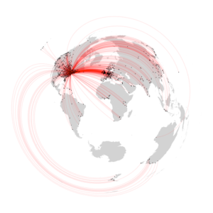
Worldwide travel distances to the 2019 AAG meeting. By Justin Schuetz

The AAG has 16 members as part of a delegation to observe the proceedings in Glasgow, and we are proud to participate in this crucial meeting of world leaders.  

However, what actions can we take to reduce carbon emissions arising from AAG activities? The Climate Action Task Force members have worked tirelessly to explore new approaches to AAG meetings with a goal of reducing emissions by 50% by 2030 (and net zero by 2050).
 
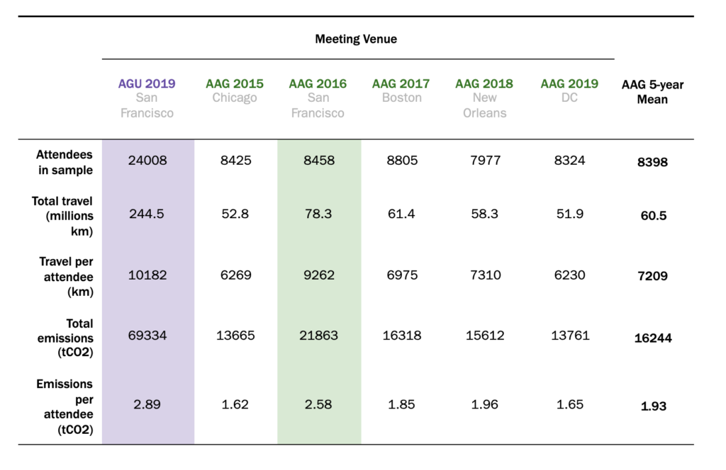
To assist in this process and to help us set baselines and explore future options, I am pleased to release an internal AAG report estimating the carbon emissions and the annual meeting. Using the same methods as Klöwer, Hopkins et al., we applied estimates of emissions from travel from the last five in-person meetings (2015-2019). This method, which assumes direct travel from each participant’s home institution to the meeting site, allows us to calculate a baseline of emissions to compare future scenarios. Here is a good summary table of the results. 

This table offers summary statistics for five AAG meetings and one AGU meeting. On average, AAG meetings from 2015-2019 had carbon footprints that were approximately 23% the size of the AGU footprint for 2019. This difference was due to AAG having, on average, 34% the number of attendees as AGU. In addition, the average AAG attendee traveled only 71% as far as the average AGU attendee. The AAG meeting in San Francisco was closest to the AGU conference in terms of travel and emissions. Source: AAG (2021) Carbon Emissions Associated with Travel to AAG Annual Meetings. Unpublished analyses prepared for the American Association of Geographers by JGS Projects, October 2021, 28 pp.

We also looked at future meetings. As with all academic societies and organizations with large meetings, the AAG signs hotel contracts five or more years in advance. Our contracted meetings are Denver (2023), Honolulu (2024), and Detroit (2025). Based on our projections, AAG 2024 in Honolulu will have much higher emissions than typical meetings (35k vs. 16.5k tCO2). Our contracts make cancellation prohibitive and encourage us to look for alternative solutions. For these reasons, we seek to partner with another geography society to offer additional locations or ‘hubs,’ perhaps in Europe or Canada. Surprisingly, adding additional hubs can reduce emissions impacts dramatically, even well below our five-year average (9k vs. 35k tCO2).  

To cut carbon emissions, we will need to experiment with new ways of conducting our meetings to meet our emission goals. And, by all indications, AAG members are eager to embrace new ways to meet and create knowledge together. This eagerness is evident on so many fronts, ranging from the strong registration rates for AAG 2022 to the enthusiastic participation in AAG Regions Connect in October and virtual webinars throughout the year. Being willing to try new solutions is not a recipe for getting everything right the first time, yet it is the best and only way to get things right in the end.  


Please note: The ideas expressed by Executive Director Gary Langham are not necessarily the views of the AAG as a whole. Please feel free to email him at glangham [at] aag [dot] org.


    Share