Jennifer Clapp is this year’s AAG Honorary Geographer. She is recognized for her groundbreaking work at the intersection of global economy, food systems, and food security, along with her commitment to praxis, including her current service as a member of the International Panel of Experts on Sustainable Food Systems (IPES-Food), and her previous service on the Steering Committee of the High-Level Panel of Experts on Food Security and Nutrition (HLPE-FSN) of the United Nations Committee on World Food Security (CFS) from 2019-2023 (vice chair 2021-2023).
She is a professor and Canada Research Chair in Global Food Security and Sustainability in the School of Environment, Resources and Sustainability at the University of Waterloo. Her recent books include Titans of Industrial Agriculture: How a Few Giant Corporations Came to Dominate the Farm Sector and Why it Matters (MIT Press, 2025), Food, 3rd edition (Polity, 2020), Speculative Harvests: Financialization, Food, and Agriculture (Fernwood Press, 2018), and Hunger in the Balance: The New Politics of International Food Aid (Cornell University Press, 2012).
Dr. Clapp is a Fellow of the Royal Society of Canada and an International Fellow of the Swedish Royal Academy of Agriculture and Forestry. She has also received numerous awards for her interdisciplinary research, including a Killam Research Fellowship, the Innis-Gérin Medal for contributions to Social Sciences from the Royal Society of Canada, a Pierre Elliott Trudeau Foundation Fellowship, the Canada Council for the Arts Molson Prize, and the Canadian Association for Food Studies Award for Excellence in Research.
We are honored to recognize Dr. Jennifer Clapp as Honorary Geographer, 2026.
Share
News
Announcing a New Specialty Group at AAG: Critical Islands, Archipelagos, and Oceans (CIAO)
From CIAO founding members Meagan Harden, Marina Karides (Chair), Neha Kohli, and Emily Mitchell-Eaton
We are thrilled to announce the launch of the AAG’s newest specialty group, Critical Islands, Archipelagos, and Oceans (CIAO). CIAO is a scholarly and activist community committed to advancing the study of islands, archipelagos, and oceans as lived spaces and geographic forms enabling for critical thought. In the present moment of environmental injustice, capitalist failure, and the enduring realities of colonialism that work to divide us, we are dedicated to building solidarities across—and through—oceanic space.
CIAO’S vision
We envision CIAO as a dynamic space for geographers, Islanders, and others committed to social justice to convene in the co-creation of knowledge specific to islands, archipelagos, and oceans. In this spirit, we invite diverse perspectives that adopt a critical lens to interrogate the following topics:
Migration, mobility, and transoceanic networks
Archipelagic relationalities
Indigenous sovereignty
Island economies
Oceanic borders, territorialities, and governance
Responses to climate change
Militarism and militarization
Island feminism and island-based social movements
Indigenous futurisms
These topics are starting points rather than constraints and we welcome scholarly engagement beyond these themes.
CIAO’S activities
Upon joining CIAO, members can look forward to the following activities:
Virtual and in-person networking opportunities
Professional development and peer mentoring
Student travel grants
Awards for outstanding papers and creative scholarship
Conference activities at the AAG Annual Meeting including paper/panel sessions, social gatherings, and organized field trips.
At AAG 2026, CIAO will sponsor:
A session titled “Island Feminisms: Anti-racist and Decolonial Scholar-Activist Solidarities for Social and Environmental Justice/Feminismos isleños: solidaridades antirracistas y decoloniales entre académicas/os activistas por la justicia social y ambiental”
A panel
Any relevant sessions that AAG members suggest!
CIAO’S commitments
As a Specialty Group that explicitly recognizes the colonial legacy of the geography discipline, as well as the myriad ways that academia reinforces social, political, and economic inequalities, CIAO is committed to building an inclusive space safe from discrimination and violence. In addition to the professional benefits of CIAO membership, CIAO is committed to:
Celebrating and amplifying the voices of Islander and coastal communities; Indigenous peoples, women, people of color, and other marginalized communities
Upholding academic freedom within CIAO activities;
Facilitating transparent and accountable governance; and
Aligning with the AAG’s ethics of care for creating safe space at AAG Meetings, its Statement of Professional Ethics, and Professional Conduct Policies and Procedures
Join CIAO today
We warmly invite all geographers conducting critical work on islands, archipelagos, and oceans to join the CIAO community.
From My AAG Dashboard, click on the red “Add a Group” link in the My Communities section.
Review your current groups, then click the grey “Continue” button in the lower right.
When the Specialty Groups list appears (it may take a minute), check the box next to “Critical Islands, Archipelagos, and Oceans,” then click “Continue.”
Continue through the Affinity Groups and Communities of Practice screens until you reach your Shopping Cart, then proceed to Checkout. Fees are $20 for regular members and $5 for students.
Once payment is complete, you’ll see a confirmation message. Allow up to 15 minutes for your dashboard to update. If the update doesn’t appear, try logging out and back in—or use a private browser window to clear any caching issues.
We are so excited to host this new space, and we can’t wait to build the CIAO community with you!
Share
On the Map
Where in the World: Renewed Care for Old Agricultural Land
A tractor sits in monocrop plots. Credit: Marcio Silva, Getty Images
Geography in the News is an educational series offered by the American Association of Geographers for teachers and students in all subjects. We include vocabulary, discussion, and assignment ideas at the end of each article.
By Emily Frisan
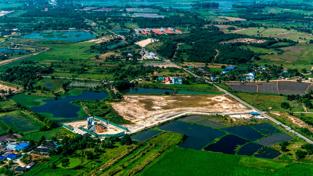
The world will have to feed 10 billion people by 2050. For the past 60 years, agricultural production has been driven by management of labor, technological advancements, and the expansion of irrigated areas. In the United States, the rise of single-crop farming became more intense in the early 20th century. It powered a larger scale of production so we could feed a rapidly increasing global population. Despite this, over 735 million people worldwide still go to bed hungry each night.
The world’s agricultural land can be divided into two basic categories: cropland and land for livestock (pastureland). As of 2020, both of these cover 32 of the world’s total land area. That’s nearly 8% growth since 1961. Farms and pastures cover 40 of all habitable land in the world, about 4.2 billion hectares.
The immense agricultural space and over 14,000 edible plant species should mean more diversified food choices. Yet 75% of the world’s food comes from just twelve plant species and five animal species. Wheat, corn, and rice together provide nearly half of the world’s plant-derived calories. These major crops are often grown at large scales as “monocultures:” a single crop grown alone in large fields.
Where the World’s Food Grows
Before European colonization, thousands of ecosystems, species of plants, and animals thrived in regions worldwide. Agriculture was more local. Communities were rooted in local traditions for caring for land and growing food. Today, these major food-producing regions include Africa, Asia, and parts of North and South America.
Credit: Tom Fisk, Pexels
The Global North and Global South are terms used to group countries based on their wealth and development. These categories are sorted to understand differences in how countries are similar economically and politically. Typically, the Global South countries’ economies depend on shipping out agricultural products and raw materials. While crops are grown worldwide, in 2020, the Global South accounted for 73% of agricultural production across the world. This has increased 33% since 1961.
Crops and livestock vary in different geographic regions. This might be due to climate, native species, or economic and cultural significance. For instance, the United States is a major producer of corn and soybeans. Countries like India and China are producers of rice and wheat. Explore this interactive map to learn about where your food comes from — past and present.
Old Techniques for New Growth
Feeding the world’s people is not as easy as expanding farmland. That would come at the cost of forests and other ecosystems. This further contributes to biodiversity loss and climate change. Agriculture is a leading cause of habitat loss, using 70% of global water use and releasing over 25% of the earth’s greenhouse gas emissions. Increasing agricultural productivity without using more land is essential. It is being lost to urban sprawl, erosion, sea level rise, change in climate, and chemical pollution.
An answer to these growing problems includes looking to Indigenous agriculture management systems. These practices include a wide range of techniques. For example, intercropping is used with multiple species of plants, such as the Three Sisters (corn, beans, and squash). Crop rotation is used to preserve soil health. Also, farmers can burn certain sections of the forest to clear the land for agriculture and encourage “interspecies synergies” where animals benefit from working together.
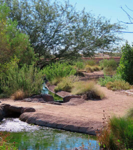
Mission Garden (Tucson) demonstrates the acequia system that used to bring Santa Cruz River water to area crops. Source: Wikimedia Commons
Once set aside by Western water managers, traditional irrigation practices like the “acequia system” can improve water quality using physical geography. Gravity carries water downhill. This slowly distributes minerals and rich soil throughout the landscape. Acequia developed from Native people’s experiences farming in the Southwest United States. The Acequia Institute in San Luis, Colorado, is one organization that is working to bring back traditional farming practices. They hope to revive Indigenous methods that work with natural water systems to introduce a closer connection of food and nutrition to the community.
And that is Geography in the News, updated October 10, 2025
Material in this article comes from “World Agricultural Land” (1997), an original article for Geography in the News by Neal Lineback, Appalachian State University.
AAG’s Geography in the News is inspired by the series of the same name founded by Neal Lineback, professor and the chair of Appalachian State University’s Department of Geography and Planning. For nearly 30 years from 1986 to 2013, GITN delivered timely explainer articles to educators and students, relevant to topics in the news. Many of these were published on Maps.com’s educational platforms and in National Geographic’s blogs. AAG is pleased to carry on the series.
Sources Consulted for this Article
Alliance of Bioversity International and the International Center for Tropical Agriculture (CIAT) 2016. Where Our Food Crops Come From.
Agrobiodiversity: Variety of animals, plants, and microorganisms used directly or indirectly for food and agriculture.
Agroecology: An approach that applies ecological and social concepts and principles to food and agricultural systems.
Food Gap: Refers to the disparity between those who have access to healthy food and those who don’t.
Food Insecurity: The condition of not having access to sufficient food, or food of an adequate quality, to meet one’s basic needs.
Food Desert: An area in which it is difficult to buy affordable or good-quality fresh food.
Food Swamp: Refers specifically to places where unhealthy foods like fast food are more readily available than nutritious options and grocery stores.
Global North: Refers to a group of countries that are generally more economically developed and wealthier, primarily located in Europe, North America, and developed parts of Asia.
Global South: Refers to a group of countries that are often characterized as developing or underdeveloped in regions such as Africa, Latin America, and parts of Asia.
Habitable land: Land that is suitable for human settlement.
Irrigation: The supply of water to land or crops to help growth.
Monoculture: The agricultural practice of cultivation of a single crop in a given area.
Plant-Derived Calories: The calories eaten from foods mainly derived from plants (fruits, vegetables, nuts, seeds, oils, grains, and beans).
Questions for Discussion and Further Study
What has characterized agriculture for the past 60 years, and what are some alternative agricultural methods to feed the world’s growing population?
Consider what you ate for one meal yesterday. How many types of plants or animals were part of your meal?
Look up one of the 12 plant species and 5 animal species our agriculture relies on: can you find out why that species became such a staple of our diets? What is its history? Can you find information about a once-common food crop that is no longer popular?
Does anyone in your family garden, and do they have tips or family secrets for managing water or plants?
If we can’t simply expand our farmland to feed more people, what are some other solutions that the article did not mention?
Share
On the Map
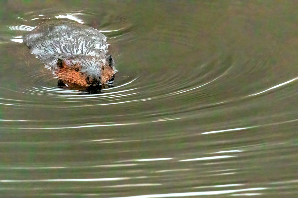
North American Beavers in South American Forests?
Beaver in its natural habitat in Northern Ontario. Credit: Camerauthor Photos, Unsplash
Geography in the News is an educational series offered by the American Association of Geographers for teachers and students in all subjects. We include vocabulary, discussion, and assignment ideas at the end of each article.
By Cadence Bowen
Patagonia, a remote region at the tip of South America, has some long-distance intruders. In 1946 the North American beaver (Castor canadensis), was brought here. Its population has thrived—to the dismay of local humans.
The story of beavers in Patagonia shows how humans can introduce invasive species. These are non-native species which can overrun native species. This often causes an imbalance in the ecosystems in these environments. The problem of invasive species is driven by human interests, such as commercial or agricultural use of animals or plants.
North American beavers were almost wiped out in their native habitats by 1900. They were saved through intense conservation. Ironically, in Patagonia the focus is how to get rid of them. The Wildlife Society’s Pablo Jusim says, “Technically, it’s viable to eradicate beavers from South America—one of the biggest eradications in the world if we achieve it.” He estimates a cost of about $31 million and 20 to 30 years to eliminate Patagonian beavers and restore ecological balance.
Well, How Did They Get Here?
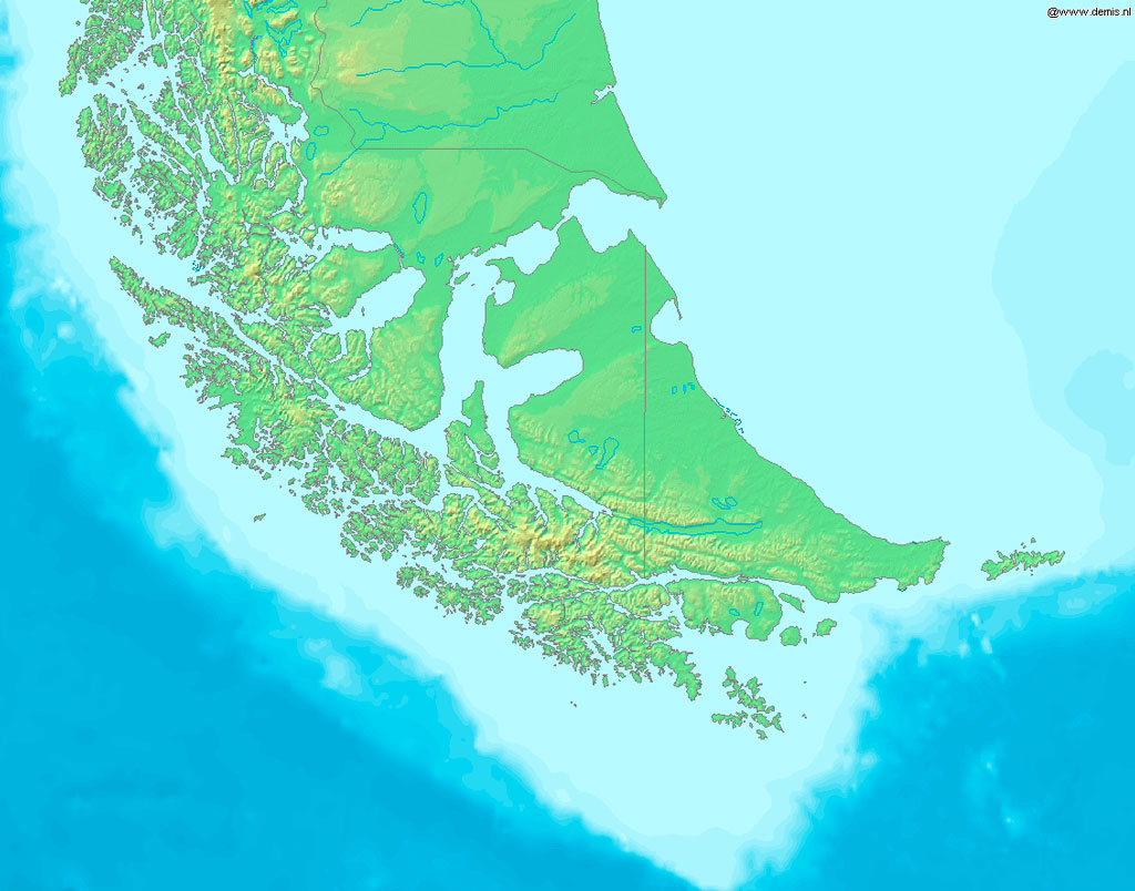
Imagine the southernmost part of South America: that’s Patagonia. Part of both Chile and Argentina, Patagonia is known for its diverse geography. Snowy mountains and lush forests in the west are answered by steppes and deserts in the east. The archipelago of Tierra del Fuego is at the tip of this area. It has its own diverse and rugged terrain, from lowlands and glaciated coasts in its north to high mountains in the east.
Map showing Patagonia and Tierra del Fuego. Credit: Wikimedia Commons
In 1946, the Argentine government introduced just 20 North American beavers to Tierra del Fuego. The intention was to kickstart a fur trade for pelts. Officials believed the climate would be similar enough to the beavers’ native climate to suit them. Little thought was given to native trees, plants, and ecosystems. The trees and forests of North America co-evolved with beavers and can take their energetic tree felling and dam building. The native forests of Tierra del Fuego had never experienced anything like this. Plus, beavers have no natural predators in Tierra del Fuego. Eighty years later, the species’ population is more than 150,000, almost outnumbering human inhabitants.
Impacts of these “Ecosystem Engineers”
Beavers are ingenious animals with the ability to alter the landscapes they inhabit. These furry creatures are admired for their important roles in North America, both their contributions to river ecologies, and their earlier pivotal role in the fur trade of early America. They shape the environment more than any other species besides humans. Kodi Jo Jaspers, manager of the Wenatchee Beaver Project in Washington State, calls them “ecosystem engineers.”
When beavers build dams in North America, they create habitat for a lot of different species. This can help address the impacts of climate change by retaining groundwater, absorbing rain, and stopping or slowing the spread of wildfires.
Beavers’ impacts in North American ecosystems don’t translate well to the South American islands of Tierra del Fuego. They have become destructive toward its pristine forests and rivers. They lack the natural predators that North American beavers face, such as bears, wolves, and coyotes. Their natural behavior—gnawing trees and building dams—causes the roots of the remaining trees to rot in the saturated soil. Eventually, these trees to die. The river systems and watersheds that support life on the islands are filled with dead flora and sediment.
“I admire the animal actually. … How it works with the rivers, how it is adapted, how they molded nature for their own benefit, builds his house, his dams. ”
—Pablo Kunzle, Interviewee in Beavers: Patagonia Invaders
Is there a future Patagonia without beavers?
The 2015 documentary, Patagonia Invaders, highlights the community response to Tierra del Fuego’s beavers. From trendy fur coats to beaver tenderloins, locals have taken unusual steps to reduce the numbers of these invasive critters and their continuing impacts.
A study in the 1990s showed they had colonized about 94% of the rivers in the archipelago. Peacefull population control measures had limited results. In 2015, the Argentine government began a three-year eradication project. They applied the toughest means: full-body traps and hunting. The approach was successful enough for The Wildlife Society to recommend a larger-scale approach.
Researcher Mara Dicenta coined the term “Beavercene” to describe the changed landscape of Tierra del Fuego since 1946. She views the introduction and attempted eradication of beavers there as two ends of the same spectrum, caused by “a history of colonial interventions that ignore local environments.”
The latest approach to managing beavers in Tierra del Fuego’s forests might result in harmony or further destruction. In a fragile place that is out of balance, that question still hangs in the balance.
And that is Geography in the News, updated October 10, 2025
Material in this article comes from “North American Beavers Destroy South American Habitat” (2008), an original article for Geography in the News by Neal Lineback and Mandy Lineback Gritzner.
AAG’s Geography in the News is inspired by the series of the same name founded by Neal Lineback, professor and the chair of Appalachian State University’s Department of Geography and Planning. For nearly 30 years from 1986 to 2013, GITN delivered timely explainer articles to educators and students, relevant to topics in the news. Many of these were published on Maps.com’s educational platforms and in National Geographic’s blogs. AAG is pleased to carry on the series.
Jusim, P., A.P. Goijman, A. Schiavini (2025). A leap in scale for invasive species management: a medium-scale beaver eradication pilot project. Wildlife Management 89 (3), April. https://doi.org/10.1002/jwmg.22706
Archipelago: A group of islands scattered across a body of water
Co-evolve: When two or more species have evolved together over millions of years, and have influenced or supported each other’s evolution
Ecosystem: A place that is defined and shaped by the relationships and interactions of many species within it.
Flora: Broad definition for plant life
Habitat: The place where life forms live; the habitat is made up of the conditions and features of the land, as well as the habits and relationships of species living there.
Nonnative Species: Living beings that are removed from their original natural environments and introduced to another by humans
Invasive Species: Nonnative species that have traits which enable them to outcompete and threaten native species, or cause damage to habitats..
Steppes: A large area of flat, unforested grassland
Terraform: To transform an area of land, often with removal of material, new structures, or addition of non-native species of plants and animals that can change the habitat.
Watershed: A geographical area that channels precipitation to rivers, streams, or creeks to eventually reach a larger body of water, such as bays or the ocean
Questions for Discussion and Further Study
What are invasive species? What is the most common way for invasive species to be introduced?
When we talk about species that have co-evolved, are we only talking about native species?
Why were North American beavers introduced to Tierra del Fuego? What was the result of this introduction?
Why do North American beavers thrive in Patagonia?
Can you think of any invasive species in your local environment? What efforts are being made to control or eradicate the species?
Share
On the Map
The Geography of Bison: Returned from the Brink
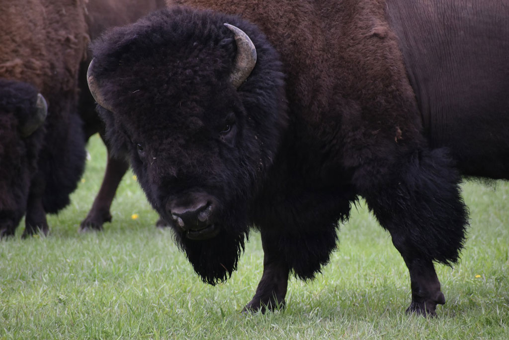
Close up image of a couple of bison from a herd at Yellowstone National Park. Credit: Taylor Wright
Geography in the News is an educational series offered by the American Association of Geographers for teachers and students in all subjects. We include vocabulary, discussion, and assignment ideas at the end of each article.
By Neal Lineback Edited by Jane Nicholson, with mapping by Rachael H. Carpenter
The American bison, commonly known as the buffalo, is an icon of the U.S. “Wild Wild West.” The wild American bison was a major food source for native Americans for thousands of years. Yet, by the 1900s, it had been hunted to near extinction by settlers, trappers, and hunters,
The bison is the largest animal native to North America. Males weigh up to a ton (2,000 lb or 1,000 kg). At the turn of the century, there were only reportedly 23 wild bison left inside the territory of Yellowstone National Park and perhaps only a few hundred or so more scattered elsewhere in the U.S. and Canada.
In attempts to salvage the species, governments, organizations, and individuals made efforts to save a few bison. Those few in Yellowstone were successfully protected and became a core of the revival of a herd whose numbers rebounded rapidly. Other captured bison were protected by enterprising farmers and agencies, some on small farms and others as the beginnings of small herds. All of these actions saved the bison’s genetic profile from extinction.
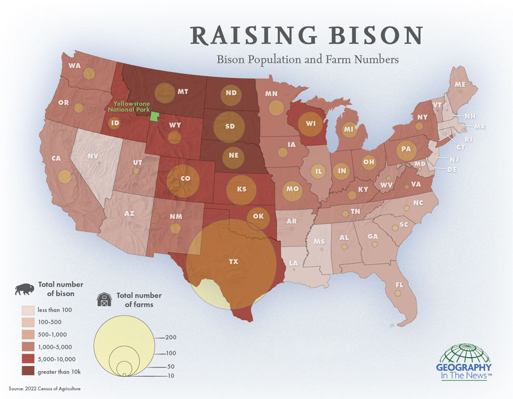
The bison is a hardy creature, able to withstand extreme temperatures, heavy snow, drought and onslaughts of most predators. The bison’s size, herding instincts and aggression help ward off wolf packs and bears, the animal’s main threats. Accord to the National Bison Association, there were 1,986 bison ranches and farms in the U.S. in 2022.
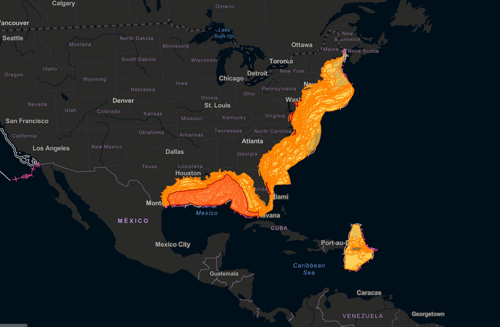
Where bison are raised in the U.S: both on ranches and public lands. Credit: Rachael H. Carpenter
Several issues still plague the bison from reviving to historic numbers. First of all, the territories available for wide-ranging herds of wild bison are very limited. Fences must be very strong and/or electrified to usually contain them, but even the strongest fencing cannot always contain bison, particularly large males. Private herds must be constantly managed. Although a large bison bull can literally run through fences when frightened, more “escapes” are caused by mating instincts where several males will push through their containing fences en masse to reach a female in estrus (ready to breed).
When they escape their containment as on bison farms surrounded by fences, bison are very hard to retrieve. They often require tranquilizer shots to neutralize their natural aggressiveness. Unlike cattle that can be rounded up with help of dogs, bison are almost immune to that process, sometimes only responding to food (grain) to lead them back into confinement.
Whereas bison escapes are mostly associated with bison farms and smaller ranches, the unfenced 4,900 bison in Yellowstone’s free-ranging herd are unconfined, which brings a new and different problem. When these bison leave the Park, they range onto surroundings under private ownership and National Forest Services land. Thus, they may cause jurisdictional problems, whereby they enter private grazing land and cropland, tear down farmers’ fences, damage farm equipment, destroy delicate ecosystems, and harass farm animals. Once on private land, they are unprotected and exposed to hunters and highway vehicles.
There are an estimated 400,000 bison in the United States, including 31,000 in conservation-focused facilities (parks and Tribal Lands), and the rest on bison farms and ranches. The Native Lands Advocacy Project (NALP) estimates that bison numbers overall increased at a rate of 13.36% between 2012 and 2017, while Tribal bison increased by 1031%. Clearly, Native Americans’ reverence for bison has enhanced the reproductive and survival rates among the herds under their care.
So what is the geographic distribution of bison in the United States today? Every state except the smallest East Coast states contains some small bison farms and larger
ranches. Most of the bison are raised as food, with the market prices for ground bison being three to five times more costly than beef. Consequently, commercial bison meat is mainly marketed to high-end restaurants and advertised as a healthy specialty item.
The word is out: Bison are BACK!!
And that is Geography in the News, updated October 1, 2025.
AAG’s Geography in the News is inspired by the series of the same name founded by Neal Lineback, professor and the chair of Appalachian State University’s Department of Geography and Planning. For nearly 30 years from 1986 to 2013, GITN delivered timely explainer articles to educators and students, relevant to topics in the news. Many of these were published on Maps.com’s educational platformsand in National Geographic’s blogs. AAG is pleased to carry on the series.
Bison — Shaggy, humpbacked ox native to North America and Europe.
Buffalo — A term used interchangeably with “bison” in North America, but actually a different of four-footed grazing mammal native to Africa.
En Masse — French for “as a group.”
Estrus — The state of a female ready to mate.
Questions for Discussion and Further Study
What happened to buffalo populations in the 1800s?
Are buffalo dangerous to humans? Why or why not?
What are some of the challenges ranches and public land managers face in raising and caring for buffalo?
Buffalo populations are increasing swiftly, but are they anywhere close to the population that once lived in North America before European settlement? See if you can use the sources above and your own search to find that information.
Share
On the Map
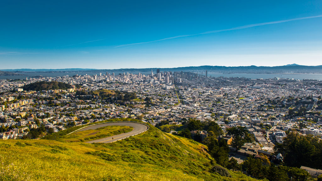
The Hills of San Francisco
Street hill gradient in San Francisco
Unlike the rest of California, San Francisco has a unique geography that shapes its weather and settlement patterns. The city is set on the tip of a peninsula halfway up the coast of northern California, surrounded by bodies of water on three of its sides: the Pacific Ocean, the Golden Gate strait, and the San Francisco Bay. The city is laid out over hills that stretch from coast to coast, reaching heights of nearly 1,000 feet, making the climate similar to coastal areas on the Mediterranean.
The hills of San Francisco define its topography and culture. It’s hard to pinpoint the exact number in the city, but many sources consider there to be more than 50 named hills. As Pulitzer Prize-winning San Francisco Chronicle columnist Herb Caen notes in his introduction to the Hills of San Francisco, no one can quite agree on which [hills]. Although it’s debated among locals, there are seven hills that are iconic to the city: Russian Hill, Nob Hill, Telegraph Hill, Twin Peaks, Mount Davidson, Mount Sutro, and Rincon Hill.
So, when is a hill a hill? Self-proclaimed San Francisco explorer Dave Schweisguth claims, “When it’s a lone mountain. That is, if you can walk all the way around it, always looking up to its summit. It’s not so clear cut when hills run together into a ridge, which most of San Francisco’s do. Height alone is not so important: a very small hill may be perfectly obvious, while a string of higher summits may be hard to tell one from the next. It’s easier to call a hill a hill if it’s separated from its neighbors — if, on a topographic map, a contour line or two traces all the way around its summit.”
The Range of Iconography
Originally named Blue Mountain for the wildflowers that cover the hillside, the city’s tallest hill was renamed Mt. Davidson at the urging of the Sierra Club in 1911, after George Davidson, the geographer who surveyed it. It is the focal point of San Francisco’s Mt. Davidson Park, with a forest that accounts for more than 30 of the park’s acres, quietly remaining an oasis in the most densely settled city in California. Defined by a 100-foot cross at its peak, Mount Davidson stands at an elevation of 928 feet. Urban hikers share that despite how small the overall area is, the trails aren’t consistently marked, which causes explorers to get lost in the woods.
Hikers also recommend Mount Sutro, located in central San Francisco, for its role in the city’s cultural and natural history. Its century-old trails are now preserved by the University of California, San Francisco, which guides the long-term restoration of the 61 acres and protects the ecological oasis in the heart of the urban environment, along with the citizen group Sutro Stewards. The city’s elevation and abundant summer fog contribute to the mountain’s microclimates and its plant and wildlife communities.
Twin Peaks view in San Francisco. Credit: optionm, Getty Images
Originally called “Los Pechos de la Choca” (Breasts of the Maiden) by early Spanish settlers, Twin Peaks is a main landmark of San Francisco’s skyline, reaching elevations of 910 and 922 feet. Similar to Mt. Davidson and Mt. Sutro, Twin Peaks hosts a 64-acre park of coastal scrub and grassland communities that offer an idea of how San Francisco’s hills and peaks looked before development changed them forever.
Early in defining San Francisco’s history, Nob Hill, Russian Hill and Telegraph Hill continue to remain among the most popular neighborhoods to visit.
Lombard street in San Francisco Lockdown. Credit: Tiago Ignowski, Getty Images
Russian Hill’s name dates to 1847 when Russian sailors were buried on the hill during the gold rush in the 1800s. The burial sites are long since deeply covered, and it’s now only possible to admire a plaque at the site where the cemetery once stood. This is the same neighborhood home to the famous Lombard Street, that draws tourists from around the world due to its scenic switchbacks and postcard views. Because the slope in this area reaches 27° (51%), 8 hairpin bends were put in the 1300 feet between Hyde Street and Leavenworth Street to allow cars to drive down the street, ultimately creating one of the most winding streets in the world.
Russian Hill borders Nob Hill to the south, one of the city’s most upscale neighborhoods. Originally called California Hill (after California Avenue, which runs right over it), Nob Hill got its name from the word “nabob” that originated from the Hindu word meaning a wealthy or powerful person. This affluent neighborhood was home to the Central Pacific Railroad tycoons known as the “Big Four,” who were among the first to build their mansions here.
View up to Telegraph Hill’s Coit Tower. Credit: slobo, Getty Images Signature
Telegraph Hill hosts Coit Tower, an iconic piece of architecture that resembles a fire hose and affords incredible views of the city; its walls are also home to historic artwork. Originally, the Tower was a windmill-like structure created in 1849 to signal ships entering the Golden Gate. Once the trek is completed, the summit provides a breathtaking panoramic view of the city with landmarks like the Golden Gate Bridge, Alcatraz, and the Transamerica Pyramid.
Whether you’re taking a leisurely stroll or hiking the steepest routes, you can recall the words of the iconic San Francisco journalist Herb Caen, who once said, “Take anything from us — our cable cars, our bridges, even our Bay — but leave us our hills.”
You can hit the trails with a guided tour or explore the city on your own. The SF Gatecompiled a list of 11 hikes within the city limits that allow visitors and residents to get to know the landscape. An interactive map created by a UC Berkeley graduate student studying urban planning maps SF’s slopes and uses simple color coding to show where the flattest pockets of land are. If you’ll be attending AAG’s 2026 Annual Meeting in San Francisco, you’ll want to bring your walking shoes!
Share
On the Map
The Hidden Costs of Commercial Fishing: Sustaining Economies and Ecosystems
Geography in the News is an educational series offered by the American Association of Geographers for teachers and students in all subjects. We include vocabulary, discussion, and assignment ideas at the end of each article.
By Adeti Afe
Fishing has been a part of human life for thousands of years, helping to feed societies while maintaining a balance in marine ecosystems. Traditional fishing usually keeps fish populations in check. But now, methods for industrial-level commercial fishing can cause serious harm to marine ecosystems. Scientists warn that some of the world’s most important fishing areas and habitats could be permanently damaged due to issues like overfishing, habitat destruction, and the problems caused by aquaculture.
The National Oceanic and Atmospheric Administration (NOAA) maintains Fishmapper, an interactive mapping tool for examining important habitats for managed fish populations worldwide. Credit: NOAA
Overfishing disrupts the balance of marine life. When certain fish populations decline, predators lose their prey, and smaller fish can overpopulate. This creates even more problems in the ecosystem. Coral reefs, for instance, rely on fish to control the growth of algae. Without enough fish, algae can grow uncontrollably, killing the reef’s ecosystem.
The United Nations’ Food and Agriculture Organization (FAO) reports that more than one-third of global fisheries are overfished. Over the past 50 years, the number of overfished areas has tripled. A major factor contributing to this is bycatch, which is the unintentional capture of animals like sea turtles, dolphins, and sharks in fishing nets. Millions of animals are killed this way each year, adding to the damage in already struggling ecosystems. Sea turtles are often caught unintentionally by getting tangled in nets and are harmed before they can be freed. Similarly, endangered species such as certain whales and dolphins suffer high mortality rates due to poor fishing practices. Bycatch damages the biodiversity necessary for healthy ecosystems.
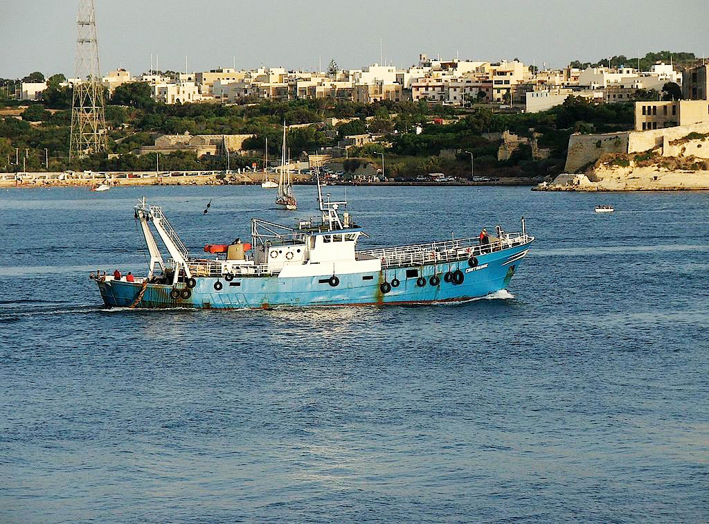
A trawler in Malta. Trawlers drag nets through the sea, either above the sea floor or along the sea floor. This method of fishing is indiscriminate and has negative impacts on sea ecologies. It is banned in many areas. Source: Peter Grima
The methods used in industrial fishing often cause harm to underwater habitats. Bottom trawling, for example, involves dragging heavy nets along the seafloor. While effective at capturing fish, this practice devastates coral reefs and seagrass beds, which are essential habitats for many marine species.
The Complex World of Fish Farming
To meet the growing global demand for seafood, many businesses have turned to aquaculture, also known as fish farming. On the surface, aquaculture appears to be a solution to overfishing, but it introduces its own set of environmental and ethical concerns. Farmed fish are often raised in overcrowded enclosures, which can lead to water pollution from waste.
Aquaculture relies heavily on fishmeal and fish oil derived from wild-caught fish, which means it continues to put pressure on already overfished stocks. Escaped farmed fish can further disrupt ecosystems by competing with native species for resources or introducing genetic and behavioral differences that harm wild populations.
Finding a Better Way
The negative effects of commercial fishing extend beyond the environment, impacting human communities. Illegal, unreported, and unregulated (IUU) fishing increases the problem. Operating outside the bounds of international and local laws, IUU fishing often targets the waters of vulnerable nations. This practice robs local fishers of their resources and disrupts efforts to maintain sustainable fishing practices.
Several actionable steps can mitigate the damage caused by commercial fishing. Stricter regulations on fish catch limits and the establishment of marine protected areas (MPAs) can help ecosystems recover and maintain biodiversity. MPAs provide safe zones where marine life can thrive without the pressure of fishing.
Technological advancements can also play a role by including selective fishing gear that can reduce bycatch. Consumers can make a difference by choosing sustainably sourced seafood, certified by organizations such as the Marine Stewardship Council (MSC).
Commercial fishing is essential for feeding millions of people around the world, but it comes at a cost. Our oceans, and the communities that depend on them, are under serious pressure from overfishing, habitat destruction, bycatch, and unsustainable fish farming. These practices are pushing marine ecosystems to their breaking point. The good news is that we still have a chance to make a difference. By enforcing smarter regulations, using better technology, and making informed choices as consumers, we can create a fishing industry that works well with the environment. If we act now, we can protect the health of our oceans and ensure they continue to provide for generations to come.
And that is Geography in the News, updated January 31, 2024.
Material in this article comes from “Gone Fishing, or, Who Will Catch the Last One?” (1999), an original article for Geography in the News by Neal Lineback, Appalachian State University.
Food and Agriculture Organization of the United Nations. (2020). The State of World Fisheries and Aquaculture 2020: Sustainability in action. FAO. https://www.fao.org/3/ca9229en/ca9229en.pdf
Martinez-Porchas, Marcel, and Luis R. Martinez-Cordova. 2012. “World Aquaculture: Environmental Impacts and Troubleshooting Alternatives.” The Scientific World Journal 2012, 1-7. https://doi.org/10.1100/2012/389623.
Overfishing: Catching fish faster than they can reproduce.
Bycatch: Sea creatures caught accidentally in fishing nets.
Bottom trawling: A harmful fishing method where nets are dragged along the ocean floor.
Aquaculture: Raising fish in farms for food, also known as fish farming.
Fishmeal: A food made from ground-up fish, often used to feed farmed fish.
IUU fishing: Illegal, unreported, and unregulated fishing that breaks fishing laws.
Marine protected area (MPA): Parts of the ocean where fishing is restricted or banned to protect ecosystems.
Marine Stewardship Council (MSC): An organization that certifies seafood as sustainable.
Questions for Discussion and Further Study
What are some of the main environmental issues caused by commercial fishing, and how do they affect marine life?
The article mentions how overfishing impacts local fishing communities and their ability to make a living. How do you think these communities might respond?
Do you believe fish farming could be a solution to overfishing? Why or why not?
What actions can governments, companies, and individuals take to make commercial fishing more sustainable for future generations?
Franklin, Buenemann Join Annals of the American Association of Geographers as New Editors
Rachel Franklin will take a new position as General Geography/Cross-discipline Editor, and Michaela Buenemann is the incoming Physical Geography, Earth, and Environmental Sciences Editor at Annals of the American Association of Geographers, effective January 2025. Buenemann will replace outgoing editor David R. Butler.
Franklin is a broadly trained human geographer with research expertise in population and spatial analysis. She is professor of Geographical Analysis at Newcastle University, where she researches spatial demography and spatial inequality. She is also keenly interested in pedagogy, especially the teaching of methods. In addition to her new duties at Annals, she edits the journal, Geographical Analysis. She is a visiting academic in Population Studies at Brown University and at the Gran Sasso Science Institute (GSSI) in L’Aquila, Italy. She brings to her work at Annals extensive experience as a member of several journal editorial boards, including Population, Space and Place, the Annals, the Journal of Regional Science, and the Journal of Geographical Systems.
One of Franklin’s primary goals is to “work diligently to promote the Annals and maximize its visibility, both within and outside the discipline.” She is especially interested in highlighting the commonalities across sub-fields, finding common ground throughout the discipline.
Michaela Buenemann, incoming editor for Physical Geography, Earth, and Environmental Sciences, is professor and head of the Department of Geography and Environmental Studies at New Mexico State University. Her interdisciplinary, international, and collaborative work features contributions in GIS, remote sensing, spatial modeling, landscape ecology, and biogeography. She has published in a wide range of geography, environmental sciences, and GIScience journals, and her research has been funded by numerous state and federal agencies. In the classroom and field, she teaches an array of courses in physical geography, socio-environmental systems, field methods, geographic information science and technology, and geographic theory and research design. She has contributed to the discipline of geography in various roles, including chair of the Southwest Division of the American Association of Geographers, Southwest Regional Councilor of the American Association of Geographers, and Southwest Regional Councilor of Gamma Theta Upsilon.
Buenemann brings to her editorship the experiences of seven years on the Editorial Board of the Physical Geography, Earth, and Environmental Sciences thematic area of the Annals. She is currently co-editing an Annals Special Issue on “National Parks and Protected Places” with David Butler and also serves as an Associate Editor for Regional Environmental Change. She earned her Ph.D. in Geography from the University of Oklahoma in 2007.
We are grateful to David R. Butler, outgoing editor for Physical Geography, Earth, and Environmental Sciences. Butler is the Regents’ Professor of Geography Emeritus in the Texas State University System and an AAG Fellow. His research interests include geomorphology, biogeography, natural hazards, mountain environments, and environmental change. In 2023, Butler was awarded the AAG Lifetime Achievement Award for his contributions to the discipline.
AAG Members get exclusive access to publications, prominent journals, unique advocacy, grant, scholarship and professional opportunities with access to industry focus communities, and event discounts, including our annual meeting.
Some content may only be accessible if you belong to specific Specialty or Affinity Groups. You can still update your membership below. You will need to go through the Join flow, but you do not need to repurchase your membership unless it is expired or about to expire.
To provide the best experiences, we use technologies like cookies to store and/or access device information. Consenting to these technologies will allow us to process data such as browsing behavior or unique IDs on this site. Not consenting or withdrawing consent, may adversely affect certain features and functions.
Functional
Always active
The technical storage or access is strictly necessary for the legitimate purpose of enabling the use of a specific service explicitly requested by the subscriber or user, or for the sole purpose of carrying out the transmission of a communication over an electronic communications network.
Preferences
The technical storage or access is necessary for the legitimate purpose of storing preferences that are not requested by the subscriber or user.
Statistics
The technical storage or access that is used exclusively for statistical purposes.The technical storage or access that is used exclusively for anonymous statistical purposes. Without a subpoena, voluntary compliance on the part of your Internet Service Provider, or additional records from a third party, information stored or retrieved for this purpose alone cannot usually be used to identify you.
Marketing
The technical storage or access is required to create user profiles to send advertising, or to track the user on a website or across several websites for similar marketing purposes.
 Jennifer Clapp is this year’s AAG Honorary Geographer. She is recognized for her groundbreaking work at the intersection of global economy, food systems, and food security, along with her commitment to praxis, including her current service as a member of the International Panel of Experts on Sustainable Food Systems (IPES-Food), and her previous service on the Steering Committee of the High-Level Panel of Experts on Food Security and Nutrition (HLPE-FSN) of the United Nations Committee on World Food Security (CFS) from 2019-2023 (vice chair 2021-2023).


 Michaela Buenemann, incoming editor for Physical Geography, Earth, and Environmental Sciences, is professor and head of the Department of Geography and Environmental Studies at New Mexico State University. Her interdisciplinary, international, and collaborative work features contributions in GIS, remote sensing, spatial modeling, landscape ecology, and biogeography. She has published in a wide range of geography, environmental sciences, and GIScience journals, and her research has been funded by numerous state and federal agencies. In the classroom and field, she teaches an array of courses in physical geography, socio-environmental systems, field methods, geographic information science and technology, and geographic theory and research design. She has contributed to the discipline of geography in various roles, including chair of the Southwest Division of the American Association of Geographers, Southwest Regional Councilor of the American Association of Geographers, and Southwest Regional Councilor of Gamma Theta Upsilon.
 We are grateful to David R. Butler, outgoing editor for Physical Geography, Earth, and Environmental Sciences. Butler is the Regents’ Professor of Geography Emeritus in the Texas State University System and an AAG Fellow. His research interests include geomorphology, biogeography, natural hazards, mountain environments, and environmental change. In 2023, Butler was awarded the AAG Lifetime Achievement Award for his contributions to the discipline.