The Hills of San Francisco

Street hill gradient showing homes built on a slope with cars parked on the deeply slanted street.
Street hill gradient in San Francisco

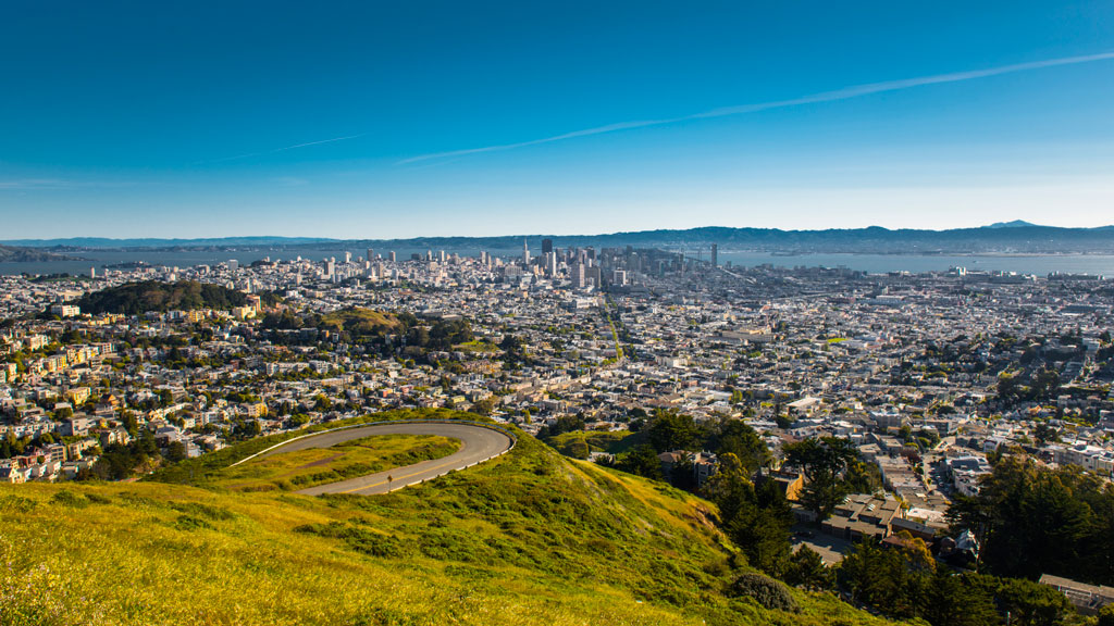
Unlike the rest of California, San Francisco has a unique geography that shapes its weather and settlement patterns. The city is set on the tip of a peninsula halfway up the coast of northern California, surrounded by bodies of water on three of its sides: the Pacific Ocean, the Golden Gate strait, and the San Francisco Bay. The city is laid out over hills that stretch from coast to coast, reaching heights of nearly 1,000 feet, making the climate similar to coastal areas on the Mediterranean.

The hills of San Francisco define its topography and culture. It’s hard to pinpoint the exact number in the city, but many sources consider there to be more than 50 named hills. As Pulitzer Prize-winning San Francisco Chronicle columnist Herb Caen notes in his introduction to the Hills of San Francisco, no one can quite agree on which [hills]. Although it’s debated among locals, there are seven hills that are iconic to the city: Russian Hill, Nob Hill, Telegraph Hill, Twin Peaks, Mount Davidson, Mount Sutro, and Rincon Hill.

So, when is a hill a hill? Self-proclaimed San Francisco explorer Dave Schweisguth claims, “When it’s a lone mountain. That is, if you can walk all the way around it, always looking up to its summit. It’s not so clear cut when hills run together into a ridge, which most of San Francisco’s do. Height alone is not so important: a very small hill may be perfectly obvious, while a string of higher summits may be hard to tell one from the next. It’s easier to call a hill a hill if it’s separated from its neighbors — if, on a topographic map, a contour line or two traces all the way around its summit.”

The Range of Iconography

Originally named Blue Mountain for the wildflowers that cover the hillside, the city’s tallest hill was renamed Mt. Davidson at the urging of the Sierra Club in 1911, after George Davidson, the geographer who surveyed it. It is the focal point of San Francisco’s Mt. Davidson Park, with a forest that accounts for more than 30 of the park’s acres, quietly remaining an oasis in the most densely settled city in California. Defined by a 100-foot cross at its peak, Mount Davidson stands at an elevation of 928 feet. Urban hikers share that despite how small the overall area is, the trails aren’t consistently marked, which causes explorers to get lost in the woods.

Hikers also recommend Mount Sutro, located in central San Francisco, for its role in the city’s cultural and natural history. Its century-old trails are now preserved by the University of California, San Francisco, which guides the long-term restoration of the 61 acres and protects the ecological oasis in the heart of the urban environment, along with the citizen group Sutro Stewards. The city’s elevation and abundant summer fog contribute to the mountain’s microclimates and its plant and wildlife communities.


View of San Francisco from Twin Peaks showing the city skyline wrapping around several hills
Twin Peaks view in San Francisco. Credit: optionm, Getty Images


Originally called “Los Pechos de la Choca” (Breasts of the Maiden) by early Spanish settlers, Twin Peaks is a main landmark of San Francisco’s skyline, reaching elevations of 910 and 922 feet. Similar to Mt. Davidson and Mt. Sutro, Twin Peaks hosts a 64-acre park of coastal scrub and grassland communities that offer an idea of how San Francisco’s hills and peaks looked before development changed them forever.

Early in defining San Francisco’s history, Nob Hill, Russian Hill and Telegraph Hill continue to remain among the most popular neighborhoods to visit.


Aerial photo showing the curve of Lombard Street winding down the hill between homes
Lombard street in San Francisco Lockdown. Credit: Tiago Ignowski, Getty Images


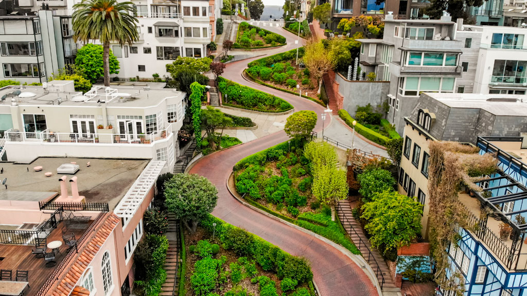
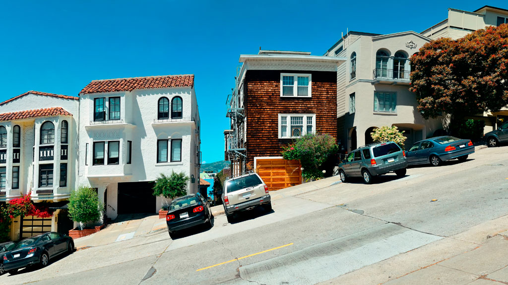
Russian Hill’s name dates to 1847 when Russian sailors were buried on the hill during the gold rush in the 1800s. The burial sites are long since deeply covered, and it’s now only possible to admire a plaque at the site where the cemetery once stood. This is the same neighborhood home to the famous Lombard Street, that draws tourists from around the world due to its scenic switchbacks and postcard views. Because the slope in this area reaches 27° (51%), 8 hairpin bends were put in the 1300 feet between Hyde Street and Leavenworth Street to allow cars to drive down the street, ultimately creating one of the most winding streets in the world.

Russian Hill borders Nob Hill to the south, one of the city’s most upscale neighborhoods.  Originally called California Hill (after California Avenue, which runs right over it), Nob Hill got its name from the word “nabob” that originated from the Hindu word meaning a wealthy or powerful person. This affluent neighborhood was home to the Central Pacific Railroad tycoons known as the “Big Four,” who were among the first to build their mansions here.


View of Telegraph Hill from below showing buildings and homes rising up to the tower atop the hill.
View up to Telegraph Hill’s Coit Tower. Credit: slobo, Getty Images Signature


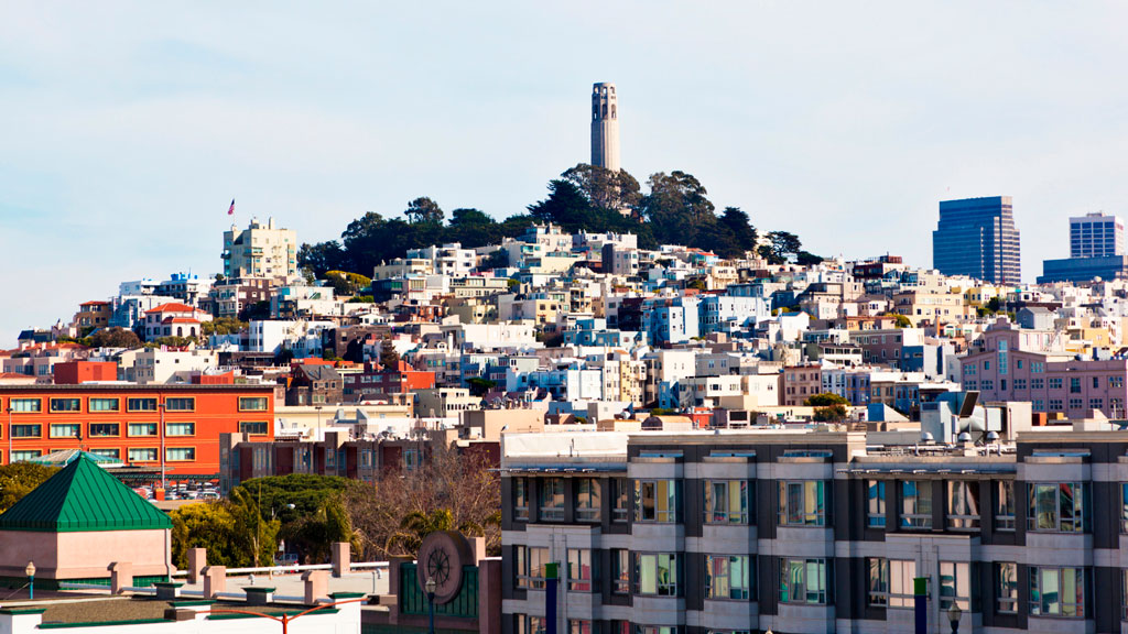
Telegraph Hill hosts Coit Tower, an iconic piece of architecture that resembles a fire hose and affords incredible views of the city; its walls are also home to historic artwork. Originally, the Tower was a windmill-like structure created in 1849 to signal ships entering the Golden Gate. Once the trek is completed, the summit provides a breathtaking panoramic view of the city with landmarks like the Golden Gate Bridge, Alcatraz, and the Transamerica Pyramid.

Whether you’re taking a leisurely stroll or hiking the steepest routes, you can recall the words of the iconic San Francisco journalist Herb Caen, who once said, “Take anything from us — our cable cars, our bridges, even our Bay — but leave us our hills.”

You can hit the trails with a guided tour or explore the city on your own. The SF Gate compiled a list of 11 hikes within the city limits that allow visitors and residents to get to know the landscape. An interactive map created by a UC Berkeley graduate student studying urban planning maps SF’s slopes and uses simple color coding to show where the flattest pockets of land are. If you’ll be attending AAG’s 2026 Annual Meeting in San Francisco, you’ll want to bring your walking shoes!

    Share

AAG Journal Articles on Black Geographies and Racial Justice

Image showing signs placed on fencing outside Lafayette Park in Washington, DC, on June 7, 2020; photo by Becky Pendergast
Credit: Becky Pendergast

The following titles reflect vital scholarship on Black Geographies in AAG’s journals in recent years. Through September 30, 2025, AAG and Taylor & Francis are providing free access to these articles, available for download at the links listed below.

For additional reading recommendations, see Black Geographies Reading List, sponsored by the AAG Black Geographies Specialty Group.

    Share

The Hidden Costs of Commercial Fishing: Sustaining Economies and Ecosystems

Image of a trawler boat sailing near Malta. Source: Peter Grima

Geography In The News logoGeography in the News is an educational series offered by the American Association of Geographers for teachers and students in all subjects. We include vocabulary, discussion, and assignment ideas at the end of each article. 


By Adeti Afe

Fishing has been a part of human life for thousands of years, helping to feed societies while maintaining a balance in marine ecosystems. Traditional fishing usually keeps fish populations in check. But now, methods for industrial-level commercial fishing can cause serious harm to marine ecosystems. Scientists warn that some of the world’s most important fishing areas and habitats could be permanently damaged due to issues like overfishing, habitat destruction, and the problems caused by aquaculture.

Image of a static map showing fish habitats off the East and Gulf Coasts, as well as in the Caribbean Sea. Credit: NOAA
The National Oceanic and Atmospheric Administration (NOAA) maintains Fishmapper, an interactive mapping tool for examining important habitats for managed fish populations worldwide. Credit: NOAA


Overfishing disrupts the balance of marine life. When certain fish populations decline, predators lose their prey, and smaller fish can overpopulate. This creates even more problems in the ecosystem. Coral reefs, for instance, rely on fish to control the growth of algae. Without enough fish, algae can grow uncontrollably, killing the reef’s ecosystem.

The United Nations’ Food and Agriculture Organization (FAO) reports that more than one-third of global fisheries are overfished. Over the past 50 years, the number of overfished areas has tripled. A major factor contributing to this is bycatch, which is the unintentional capture of animals like sea turtles, dolphins, and sharks in fishing nets. Millions of animals are killed this way each year, adding to the damage in already struggling ecosystems. Sea turtles are often caught unintentionally by getting tangled in nets and are harmed before they can be freed. Similarly, endangered species such as certain whales and dolphins suffer high mortality rates due to poor fishing practices. Bycatch damages the biodiversity necessary for healthy ecosystems.

Image of a trawler boat sailing near Malta. Source: Peter Grima
A trawler in Malta. Trawlers drag nets through the sea, either above the sea floor or along the sea floor. This method of fishing is indiscriminate and has negative impacts on sea ecologies. It is banned in many areas. Source: Peter Grima


The methods used in industrial fishing often cause harm to underwater habitats. Bottom trawling, for example, involves dragging heavy nets along the seafloor. While effective at capturing fish, this practice devastates coral reefs and seagrass beds, which are essential habitats for many marine species.

The Complex World of Fish Farming

To meet the growing global demand for seafood, many businesses have turned to aquaculture, also known as fish farming. On the surface, aquaculture appears to be a solution to overfishing, but it introduces its own set of environmental and ethical concerns. Farmed fish are often raised in overcrowded enclosures, which can lead to water pollution from waste.

Aquaculture relies heavily on fishmeal and fish oil derived from wild-caught fish, which means it continues to put pressure on already overfished stocks. Escaped farmed fish can further disrupt ecosystems by competing with native species for resources or introducing genetic and behavioral differences that harm wild populations.

Finding a Better Way

The negative effects of commercial fishing extend beyond the environment, impacting human communities. Illegal, unreported, and unregulated (IUU) fishing increases the problem. Operating outside the bounds of international and local laws, IUU fishing often targets the waters of vulnerable nations. This practice robs local fishers of their resources and disrupts efforts to maintain sustainable fishing practices.

Several actionable steps can mitigate the damage caused by commercial fishing. Stricter regulations on fish catch limits and the establishment of marine protected areas (MPAs) can help ecosystems recover and maintain biodiversity. MPAs provide safe zones where marine life can thrive without the pressure of fishing.

Technological advancements can also play a role by including selective fishing gear that can reduce bycatch. Consumers can make a difference by choosing sustainably sourced seafood, certified by organizations such as the Marine Stewardship Council (MSC).

Commercial fishing is essential for feeding millions of people around the world, but it comes at a cost. Our oceans, and the communities that depend on them, are under serious pressure from overfishing, habitat destruction, bycatch, and unsustainable fish farming. These practices are pushing marine ecosystems to their breaking point. The good news is that we still have a chance to make a difference. By enforcing smarter regulations, using better technology, and making informed choices as consumers, we can create a fishing industry that works well with the environment. If we act now, we can protect the health of our oceans and ensure they continue to provide for generations to come.

To get a glimpse of fish habitats and fishing areas mapped worldwide, use the National Oceanic and Atmospheric Administration’s Essential Fish Habitat tool.

And that is Geography in the News, updated January 31, 2024.

Material in this article comes from “Gone Fishing, or, Who Will Catch the Last One?” (1999), an original article for Geography in the News by Neal Lineback, Appalachian State University. 

Sources Consulted for this Article
Vocabulary and Terms
  • Overfishing: Catching fish faster than they can reproduce.
  • Bycatch: Sea creatures caught accidentally in fishing nets.
  • Bottom trawling: A harmful fishing method where nets are dragged along the ocean floor.
  • Aquaculture: Raising fish in farms for food, also known as fish farming.
  • Fishmeal: A food made from ground-up fish, often used to feed farmed fish.
  • IUU fishing: Illegal, unreported, and unregulated fishing that breaks fishing laws.
  • Marine protected area (MPA): Parts of the ocean where fishing is restricted or banned to protect ecosystems.
  • Marine Stewardship Council (MSC): An organization that certifies seafood as sustainable.
Questions for Discussion and Further Study
  1. What are some of the main environmental issues caused by commercial fishing, and how do they affect marine life?
  2. The article mentions how overfishing impacts local fishing communities and their ability to make a living. How do you think these communities might respond?
  3. Do you believe fish farming could be a solution to overfishing? Why or why not?
  4. What actions can governments, companies, and individuals take to make commercial fishing more sustainable for future generations?
    Share

Halal Metropolis: Making Muslim Space and Community in Detroit

Detroit After Bankruptcy: Were There Measurable Changes in the Quality of Life of the Residents?

Geographies of Resistance: The Anishinaabe in Michigan

Environmental Justice in Detroit: Power and Pollution in the 21st Century

Pitas and Passports: Arab Foodways in the Windsor-Detroit Borderlands

NSF Announces Transdisciplinary Track in HEGS Program

The Human-Environment and Geographical Sciences (HEGS) program at the U.S. National Science Foundation has published a new solicitation (NSF 25-507). Proposals submitted after October 1, 2024 should follow the new solicitation.

HEGS supports basic scientific research about the nature, causes, consequences or evolution of evolution of the spatial dimensions of human behaviors, activities, and dynamics as well as their interactions with environmental and social processes across a range of scales. The new program solicitation welcomes proposals that address these issues with empirically grounded, theoretically engaged, methodologically rigorous, and generalizable research that advances geographical and geospatial sciences.

Competitive HEGS proposals should advance fundamental geographic theory and geospatial methods with rationale to support the falsifiability of hypotheses, clear and rigorous sampling and analytical methodology, establishing validity, and generalizability to broader contexts. Regular HEGS awards range from $100,000 to $500,000, inclusive of indirect costs. Budgets must be commensurate with proposed activities and must directly support the objectives of the research. Budgets above $500,000 may sometimes be possible for proposals that are co-reviewed with other NSF programs. Prospective PIs are encouraged to contact non-HEGS program directors to discuss co-review possibilities and programmatic fit. Budget requests are reviewed carefully at all stages of the evaluation process, and proposals with budgets that are justified and appropriate to the scope of the project are prioritized. Submitters of proposals are encouraged to consult the NSF awards database for perspective on the range of budget requests that characterize the program.

A new track for proposals, Transdisciplinary REsearch in Environmental Social Science (TREES), provides funding to support research that integrates social science and environmental science to advance social sciences in understanding the complex interactions between people and the environment. TREES proposals submitted to HEGS should fuse multi-disciplinary perspectives, theories, and methods to advance the science of socioenvironmental systems and basic human-environmental and geographical sciences.TREES awards are expected to be 3–4 years in the range of $200,000–$250,000 per year.

If PIs are uncertain of the fit of a prospective project for the HEGS program (or other NSF programs), they may send a concept outline of 1 to 2 pages describing 1) the research questions and objectives, 2) theoretical foundations, 3) data collection plans, including sampling considerations, 4) analytical plans, and 5) the anticipated budget request to HEGS Program Directors ([email protected]).

HEGS depends on the willingness of qualified reviewers to provide helpful advice to NSF program directors on the merits of the proposals and constructive comments for PIs to improve their projects. Reviewers also benefit from gaining first-hand knowledge of the peer review process, learning about common problems with proposals, discovering strategies to write strong proposals, and, if serving on a panel, having dynamic and insightful discussions with other reviewers. Anyone interested in reviewing HEGS proposals please email HEGS Program Directors ([email protected]) with a short bio and a CV.

    Share