Harlem of the West: Jazz, People, and Place in the Fillmore

By Mirembe Ddumba

Stand on Fillmore and Geary streets on a Saturday evening, and you can almost hear it. Neon humming against the dusk, a saxophone warming up behind a church door, the ghost of Billie Holiday’s voice floating between the streetlights. In these few streets, jazz wrote itself onto San Francisco’s grid.

The sound arrived by train.

The Sound of Migration

During World War II, African Americans from Louisiana, Texas, and across the South boarded trains bound for San Francisco’s shipyards. Between 1940 and 1950, the city’s Black population grew tenfold, from 4,800 to 43,000, filling apartments left empty when Japanese American families were forced into internment camps.

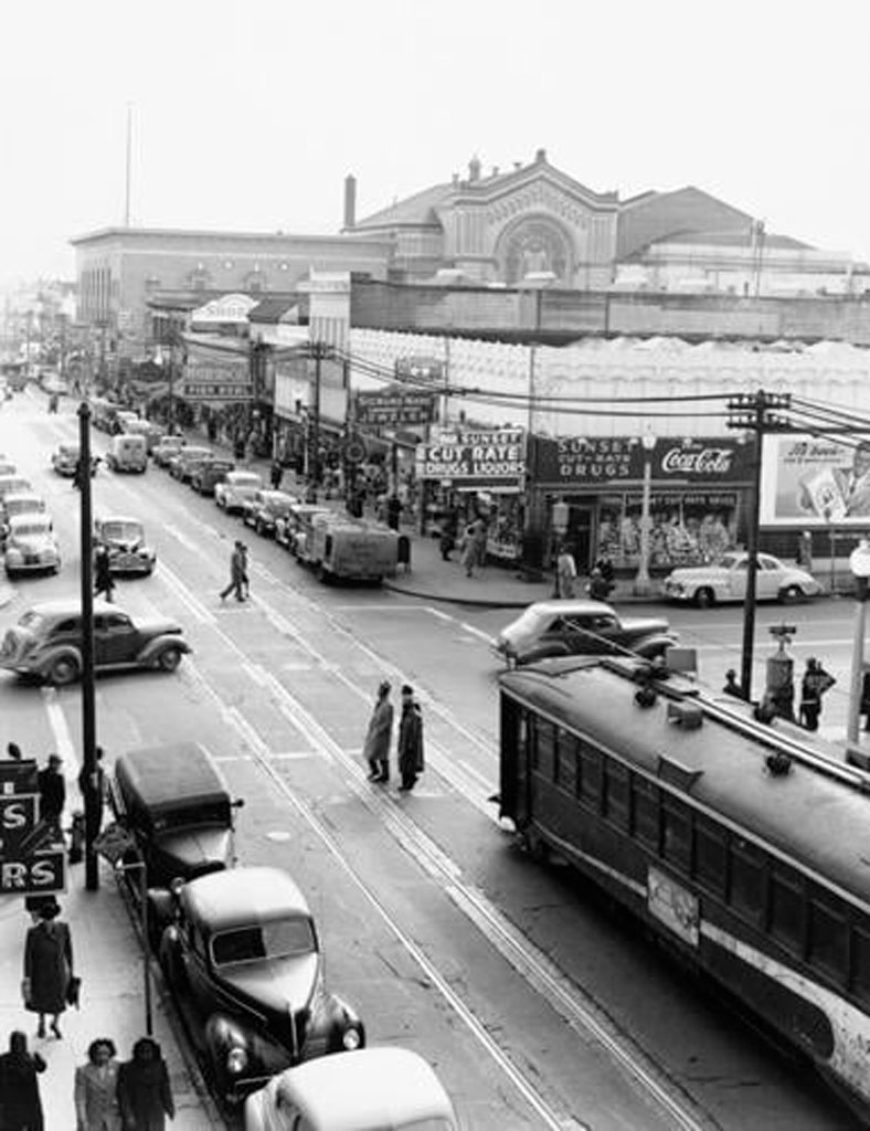
Musicians arrived with guitars slung over shoulders, horns wrapped in cloth. They transformed twenty blocks into the “Harlem of the West.” By the late 1940s, you could walk Fillmore Street on any night and hear Dizzy Gillespie bleeding through one door, smell barbecue from the next, watch Cadillacs pull up to drop off couples dressed for Jimbo’s Bop City.

Bop City at 1690 Post Street ran after-hours sessions until sunrise. Charlie Parker traded choruses with Dexter Gordon while Billie Holiday sat in a corner booth. Down the street, Ella Fitzgerald sang at the Champagne Supper Club and tried on hats between sets. The Blue Mirror. Club Flamingo. Jack’s Tavern. Two dozen venues within one square mile, each separated by a five-minute walk.

John Coltrane, Duke Ellington, Count Basie, Louis Armstrong, and Thelonious Monk rented rooms above the clubs, ate at soul food diners, bought records at local shops, and shaped the neighborhood’s sonic identity night after night. This wasn’t accidental. The grid itself made it possible.

Black-and-white photo showing Fillmore Street, south of Post Street, late 1940s. The neighborhood’s dense grid and constant traffic fueled the energy of the "Harlem of the West." Credit: David Johnson
Fillmore Street, south of Post Street, late 1940s. The neighborhood’s dense grid and constant traffic fueled the energy of the “Harlem of the West.” Credit: David Johnson


Geography as Destiny

The Fillmore’s layout made this density possible. Narrow Victorian storefronts, twenty feet wide, meant multiple clubs per block. Short blocks with corner entries created constant foot traffic. The 22-Fillmore streetcar brought audiences from downtown, turning the neighborhood into one continuous jazz experience.

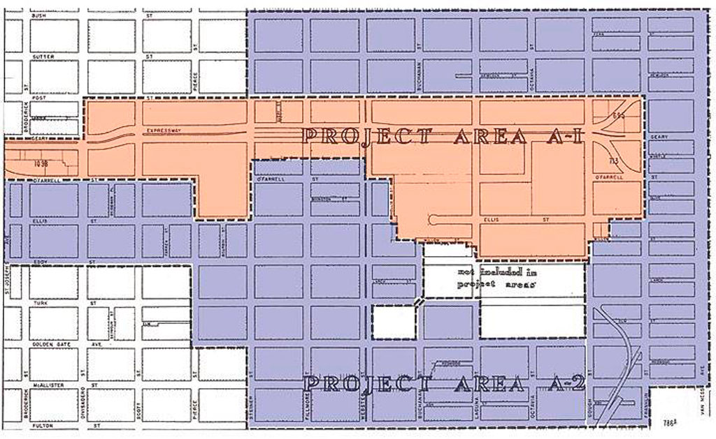
In 1948, city planners declared the Fillmore “blighted.” Under Redevelopment Agency director M. Justin Herman, bulldozers arrived. The Western Addition A-1 and A-2 projects demolished Victorian homes and shuttered clubs across 104 blocks. Geary Street, once lined with music venues, became Geary Boulevard, a four-lane expressway cutting the neighborhood in half.

By 1964, authorities had displaced 4,000 residents from A-1 alone. Jazz musicians scattered to Oakland, the East Bay, and Los Angeles. Residents gave urban renewal a different name: “Negro Removal”.


You could go out on Friday night and not come home until Sunday night because there is so much to do.”

Elizabeth Pepin Silva, filmmaker and author of Harlem of the West


The clubs closed. The musicians left. But the music never completely died.


Map showing Western Addition redevelopment zones A-1 and A-2, which demolished 104 blocks and displaced thousands of residents. Credit: San Francisco Redevelopment Agency archives
Western Addition redevelopment zones A-1 and A-2, which demolished 104 blocks and displaced thousands of residents. Credit: San Francisco Redevelopment Agency archives


Still Playing

Walk Fillmore Street now, and commemorative plaques mark where Bop City stood, where the barbershop was, where musicians bought their reeds. Listen closely, though. The Fillmore Auditorium still books acts, its walls papered with decades of concert posters. Calvary Presbyterian Church hosts Sunday jazz services. Jones Memorial United Methodist Church opens its doors for Friday night sessions.

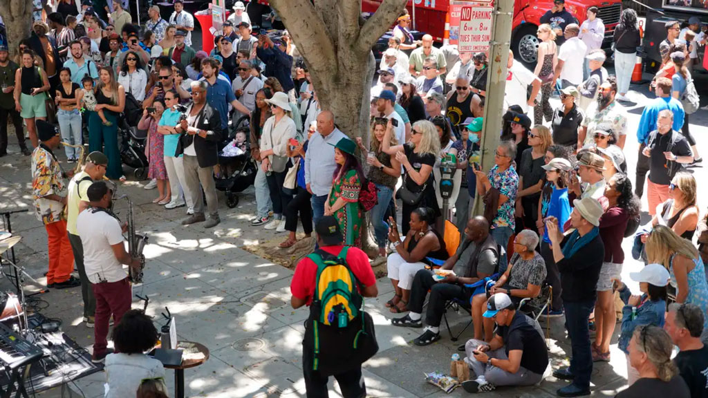
Every July since 1986, the Fillmore Jazz Festival closes twelve blocks to cars. Over 50,000 people flooded the streets for two days. Five stages. Artisan booths. The smell of Ethiopian food mixing with New Orleans-style barbecue. For one weekend, the neighborhood becomes what it was, pedestrians moving from stage to stage, music echoing off Victorian facades.

On other nights, the music lives in smaller rooms. 1300 on Fillmore books jazz acts in an intimate room with velvet couches. The Boom Boom Room sits on the corner where John Lee Hooker used to own a club. Rasselas Ethiopian Restaurant serves injera and hosts live music Thursday through Sunday. The building that housed Jimbo’s Bop City was literally picked up and moved two blocks west. It’s Marcus Books now, an Afrocentric bookstore that archives what redevelopment tried to erase.

Stand at Fillmore and Geary on Saturday evening. Close your eyes. Past the bus engines and car horns, you can still hear it. A saxophone warming up. The ghost of a neighborhood that jazz built, that policy tried to destroy, and that memory refuses to let die.

Photo showing an overhead view of musicians playing to a packed crowd at the Fillmore Jazz Festival. Credit: Fillmore Jazz Festival
Musicians play to a packed crowd at the Fillmore Jazz Festival, which brings over 50,000 people annually to celebrate the neighborhood’s musical legacy. Credit: Fillmore Jazz Festival


Learn More
    Share

AAG Honorary Geographer: Jennifer Clapp

Jennifer Clapp
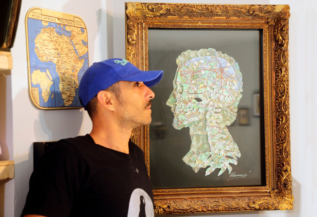
Jennifer Clapp is this year’s AAG Honorary Geographer. She is recognized for her groundbreaking work at the intersection of global economy, food systems, and food security, along with her commitment to praxis, including her current service as a member of the International Panel of Experts on Sustainable Food Systems (IPES-Food), and her previous service on the Steering Committee of the High-Level Panel of Experts on Food Security and Nutrition (HLPE-FSN) of the United Nations Committee on World Food Security (CFS) from 2019-2023 (vice chair 2021-2023).

She is a professor and Canada Research Chair in Global Food Security and Sustainability in the School of Environment, Resources and Sustainability at the University of Waterloo. Her recent books include Titans of Industrial Agriculture: How a Few Giant Corporations Came to Dominate the Farm Sector and Why it Matters (MIT Press, 2025), Food, 3rd edition (Polity, 2020), Speculative Harvests: Financialization, Food, and Agriculture (Fernwood Press, 2018), and Hunger in the Balance: The New Politics of International Food Aid (Cornell University Press, 2012).

Dr. Clapp is a Fellow of the Royal Society of Canada and an International Fellow of the Swedish Royal Academy of Agriculture and Forestry. She has also received numerous awards for her interdisciplinary research, including a Killam Research Fellowship, the Innis-Gérin Medal for contributions to Social Sciences from the Royal Society of Canada, a Pierre Elliott Trudeau Foundation Fellowship, the Canada Council for the Arts Molson Prize, and the Canadian Association for Food Studies Award for Excellence in Research.

We are honored to recognize Dr. Jennifer Clapp as Honorary Geographer, 2026.

    Share

Announcing a New Specialty Group at AAG: Critical Islands, Archipelagos, and Oceans (CIAO)

From CIAO founding members Meagan Harden, Marina Karides (Chair), Neha Kohli, and Emily Mitchell-Eaton

We are thrilled to announce the launch of the AAG’s newest specialty group, Critical Islands, Archipelagos, and Oceans (CIAO). CIAO is a scholarly and activist community committed to advancing the study of islands, archipelagos, and oceans as lived spaces and geographic forms enabling for critical thought. In the present moment of environmental injustice, capitalist failure, and the enduring realities of colonialism that work to divide us, we are dedicated to building solidarities across—and through—oceanic space.

CIAO’S vision

We envision CIAO as a dynamic space for geographers, Islanders, and others committed to social justice to convene in the co-creation of knowledge specific to islands, archipelagos, and oceans. In this spirit, we invite diverse perspectives that adopt a critical lens to interrogate the following topics:

  • Migration, mobility, and transoceanic networks
  • Archipelagic relationalities
  • Indigenous sovereignty
  • Island economies
  • Oceanic borders, territorialities, and governance
  • Responses to climate change
  • Militarism and militarization
  • Island feminism and island-based social movements
  • Indigenous futurisms

These topics are starting points rather than constraints and we welcome scholarly engagement beyond these themes.

CIAO’S activities

Upon joining CIAO, members can look forward to the following activities:

  • Virtual and in-person networking opportunities
  • Professional development and peer mentoring
  • Student travel grants
  • Awards for outstanding papers and creative scholarship
  • Conference activities at the AAG Annual Meeting including paper/panel sessions, social gatherings, and organized field trips.
  • At AAG 2026, CIAO will sponsor:
    • A session titled “Island Feminisms: Anti-racist and Decolonial Scholar-Activist Solidarities for Social and Environmental Justice/Feminismos isleños: solidaridades antirracistas y decoloniales entre académicas/os activistas por la justicia social y ambiental”
    • A panel
    • Any relevant sessions that AAG members suggest!

CIAO’S commitments

As a Specialty Group that explicitly recognizes the colonial legacy of the geography discipline, as well as the myriad ways that academia reinforces social, political, and economic inequalities, CIAO is committed to building an inclusive space safe from discrimination and violence. In addition to the professional benefits of CIAO membership, CIAO is committed to:

  • Celebrating and amplifying the voices of Islander and coastal communities; Indigenous peoples, women, people of color, and other marginalized communities
  • Upholding academic freedom within CIAO activities;
  • Facilitating transparent and accountable governance; and
  • Aligning with the AAG’s ethics of care for creating safe space at AAG Meetings, its Statement of Professional Ethics, and Professional Conduct Policies and Procedures

Join CIAO today

We warmly invite all geographers conducting critical work on islands, archipelagos, and oceans to join the CIAO community.

  1. Go to  aag.org and log in.
  2. From My AAG Dashboard, click on the red “Add a Group” link in the My Communities section.
  3. Review your current groups, then click the grey “Continue” button in the lower right.
  4. When the Specialty Groups list appears (it may take a minute), check the box next to “Critical Islands, Archipelagos, and Oceans,” then click “Continue.”
  5. Continue through the Affinity Groups and Communities of Practice screens until you reach your Shopping Cart, then proceed to Checkout. Fees are $20 for regular members and $5 for students.
  6. Once payment is complete, you’ll see a confirmation message. Allow up to 15 minutes for your dashboard to update. If the update doesn’t appear, try logging out and back in—or use a private browser window to clear any caching issues.

Questions? Contact us at [email protected].

We are so excited to host this new space, and we can’t wait to build the CIAO community with you!

    Share

Anthony Howell joins ‘Annals of the American Association of Geographers’ as newest editor

Anthony HowellAnthony Howell is the new Geographic Methods editor for the Annals of the American Association of Geographers. He is an associate professor, director of the Center on Technology, Data, and Society (CTDS), and senior sustainability scientist at Arizona State University.  Howell brings to the editorship at Annals a background in computational, geospatial and quantitative social science methods. He currently serves as an associate editor for two journals (Progress in Economic Geography and Urban Governance) as well as having served as a guest co-editor for Economic Modeling. He works across several subspecialties in geography, including economic geography, industrial geography, development geography, and population geography, as well as the broader social sciences.

Howell’s work engages with interdisciplinary scholarship, extensive international research, and quantitative, geospatial and computational social science methods. His goals for his editorship include “helping to attract, guide and strengthen the quality of cutting-edge and cross-disciplinary research, hoping to raise the profile of the journal both within and beyond the AAG community.” His approach to attracting and working with authors will draw on lessons he has learned in his own scholarly experiences–such as helping to pioneer ethnic disparities research within China relying on mixed-methods survey data collection, advanced quantitative methods, and computational social science approaches—and co-publishing with a wide variety of colleagues in geography, planning, politics, economics, and strategy. His networks have grown to be international ones, particularly focused on China and the broader Asia-Pacific region.

Dr. Howell’s term begins in January 2026.

Ling BianWe thank longtime, outgoing editor Dr. Ling Bian, an AAG Fellow and professor in the Department of Geography at the University at Buffalo. Dr. Bian has been the Geographic Methods editor of the Annals since 2018, and also serves or has served on the editorial boards of numerous geography and GIScience journals, as well as on review panels for the National Science Foundation and the National Institutes of Health. Her current research interests include conceptual and analytical frameworks for the representation of dynamic geographic phenomena, individual-based and spatially explicit modeling of health behaviors, and spatial networks. During her tenure as an Annals editor, Dr. Bian has dedicated her efforts to advancing the geography discipline by promoting intellectually in-depth and socially relevant research outcomes.

    Share

Regional Meeting Lollapalooza: Remarkable Spaces for Grassroots Innovation and Discussion

An person dressed in a dinosaur costume entertains attendees at the APCG regional division meeting
Dancing dinosaur at the Annual Meeting of the Association of Pacific Coast Geographers (APCG) in Santa Clarita, CA. Credit: Michael Pretes

William Moseley

I grew up in the Chicago area, where we have an annual lakefront, summer music festival known as Lollapalooza, featuring an eclectic collection of genres and artists. This event is fun, experimental, inflected with regional traditions, and brimming with youthful, creative energy. More generically, lollapalooza refers to something extraordinary and a way I have come to think about our AAG regional meetings. This fall I had the pleasure of attending four AAG regional division meetings: Pacific Coast, Great Plains and Rocky Mountains, Southwest, and Middle States (see figure). These encounters have been tremendous opportunities for me to meet and learn from our members. Here I reflect on some broad themes across all of the meetings, as well as some key take home messages that I gleaned from each region.

Map showing color-coded shapes including states and provinces in AAG's nine Regional Divisions
AAG Regional Divisions


Cutting across all of the regions, I was deeply impressed by the presence, energy and insights of geography students, both graduate and undergraduate. If you are ever feeling down about the headwinds facing our discipline, just spend time with our students and you will come away feeling inspired and optimistic about the future. From their scholarly endeavors shared in talks and posters, to their competitive zeal at geography bowls, to their willingness to engage in hallway conversations, I was captivated.  I also have even greater appreciation for the contributions of international students to our discipline (even beyond what I have written about previously). Their presence was notable in all of the regional meetings and they help ensure that a broad range of life experiences are brought to bear on the emerging research produced by our discipline.

I also continue to be struck by the limited presence of R1 faculty at many regional meetings. Of course, there are notable exceptions to this broader trend and I also understand that this is a not a new phenomenon. I further understand some of the reasons for this (and I am also guilty of such transgressions). Many faculty are stretched in terms of time and/or resources to attend a second or third academic conference. As such, they prioritize a national meeting where the largest number of people in their subfield are sharing their latest research findings. What is lost is stronger bonds between different types of institutions in a region as well as an opportunity for undergraduate and master’s level students to potentially meet a future advisor.

Beyond these broader themes, I was really struck by the individual character of each region and some unique lessons I learned in each place. The meeting of the Association of Pacific Coast Geographers (APCG) took place at the College of the Canyons in Santa Clarita, CA. There our outdoor barbecue on the second evening was graced by the presence of a dancing dinosaur (see Figure 2) and later that night a person in a gorilla costume briefly entered the auditorium for the keynote lecture (attesting to the fun and quirky ambiance of APCG meetings). More seriously, I was really struck by role that community colleges play in this region as a critical pipeline for future geographers (and something the discipline could build on more broadly). Some of the fastest growing geography programs in the region, such as San Diego State University, source many of their majors from surrounding community colleges. The APCG meeting also took place on a community college campus, College of the Canyons.

An person dressed in a dinosaur costume entertains attendees at the APCG regional division meeting
Dancing dinosaur at the Annual Meeting of the Association of Pacific Coast Geographers (APCG) in Santa Clarita, CA. Credit: Michael Pretes


This year’s Great Plains Rocky Mountain (GPRM) regional meeting in Omaha, NE was a joint meeting with the National Council for Geographic Educations (NCGE), our sister organization that counts many high school geography teachers among its ranks. This innovative experiment of two meetings in the same place with some cross over events created a space for bridges to be built between the parallel universes of high school and college geographers. It allowed myself and two members of the AAG taskforce on geography undergraduate education to run a workshop on the high school-to-college geography pipeline for secondary school teachers and university instructors, to speak to a mixed audience at an evening banquet, and to have dinner with the leadership of the NCGE. I could see the NCGE meeting joining with other regions in the future and I believe we could do even more to bring college faculty and high school teachers together.

The meeting of the Southwest Division of the AAG (SWAAG) took place in Las Cruces, New Mexico and was hosted by New Mexico State University. In addition to a keynote address, I participated in several panel discussions, including one on academic freedom. There I learned of state government initiatives in Texas and Oklahoma to audit course syllabi and reading lists. I further came to understand that certain words and topics are being advised against in course titles, such as decolonizing, liberation and resistance. This situation is alarming to me both personally and professionally (e.g., I have publications using several of these ‘trigger’ words). More significantly, maintaining academic freedom is a core value of the AAG and something it fights for on the national level. Nonetheless, at this regional meeting, I was deeply impressed by the way faculty were sharing experiences and advice on how to navigate such challenging circumstances. It also served as a reminder that our local experiences of speech suppression, censorship or freedom can vary greatly (and we need to be sensitive to the fact that the actions and decisions of the AAG might play out differently across regional contexts).

Lastly, the Middle States Division of the AAG (MSAAG) met at Montclair State University in Montclair, NJ. There I was impressed by the presence of deeply engaged high school teachers and their students, many of whom presented research posters. The quality of their research was striking and I believe this is an innovation that could be experimented with in other regions. What could be a better recruitment tool than to have high school students attend research presentations by grad students, or to have a professor engage with a high schooler about their project and encourage them to think about a geography degree in college.

My journey across these events left me feeling inspired by the energy and insights of our students, encouraged by the experimentation in each division, and better in-touch with political currents and challenges. This is not to say the fall AAG regional meetings are flawless, some suffer from low attendance or limited organization, but I see these as vital encounters to be improved up, not dismissed or marginalized. Fortunately, the support of AAG staff for the regions has begun to bear fruit, building on the recommendations of an AAG task force report released on the topic some five years ago. Just like a summer music festival, these are fun spaces to experience the diversity, energy and creativity of our discipline.


Please note: The ideas expressed in the AAG President’s column are not necessarily the views of the AAG as a whole. This column is traditionally a space in which the president may talk about their views or focus during their tenure as president of AAG, or spotlight their areas of professional work. Please feel free to email the president directly at [email protected] to enable a constructive discussion.


    Share

Academic Freedom and the Need for Geographers as Public Intellectuals

Geographer Katherine McKittrick and colleague Dan Charna participate in a joint book-signing at AAG 2025 in Detroit. Credit: Lisa Schamess, AAG

William Moseley

Free speech and academic freedom are increasingly under siege in the United States, with the scope and scale of speech repression nearly unprecedented. At the same time, the U.S. government is currently engaged in a vast array of domestic and foreign policy shifts, from changes in environmental regulations and naming conventions at home, to the closing of USAID operations and retreat from multilateralism abroad. Despite efforts to silence critics, these policy and program shifts deserve thoughtful public conversations that involve geographers. We need geographers as public intellectuals to continue to voice their perspective on the policies and programs of our government and others.

The tradition of the public intellectual (a form of public geography) may be contrasted with that of the ivory tower academic. Public intellectuals are scholars who take the time to address an important public debate or policy issue when they have relevant expertise and an informed perspective to offer. The public intellectual practice is more well developed in Europe, where academics regularly participate in policy discussions and are considered normal actors in public discourse. In fact, many European universities expect their faculty to comment on public issues and acknowledge this is in tenure and promotion criteria. In contrast, this practice is less well developed in the United States, with such engagement sometimes viewed as inappropriate. This distance between the American academy and public policy discussions has contributed to the ivory tower phenomenon, arguably making it more challenging for the U.S. public to feel connected to universities, their faculty and students.

To the extent that academics do participate in public policy discussions in the U.S., some disciplines tend to be over-represented, most notably economics and political science. That said, analysis that a student and I undertook over a decade ago showed that for a small discipline, geography was punching above its weight, outpacing allied disciplines such as anthropology, geology, and biology in terms of op-ed productivity per member. The geographic perspective is critical for adding to public policy discussions, be it in terms of nuance regarding spatial patterns, scale, coupled-human-environment systems or deep regional knowledge. As former AAG president Alec Murphy has argued: “our understanding of issues and problems will be impoverished if geographical perspectives are not part of the mix.”

The AAG considers the support of free speech and academic freedom to be core to its mission and has offered programming to this end. For example, in 2023, the AAG initiated the Elevate the Discipline cohort of 15 geographers to receive year-long support and training in techniques for public scholarship to inform public policy. In late October of this year, the AAG hosted a panel for department and program chairs seeking to support their faculty in terms of academic freedom. Furthermore, I am happy to report that we still have many geographers who continue to offer their perspectives on the issues of the day. Herewith three examples.

In early October, Christopher F. Meindl, associate professor of geography at the University of South Florida, published a commentary entitled “Florida’s 1,100 natural springs are under threat — a geographer explains how to restore them.” In this piece, Meindl drew on his own research as a human-environment geographer, and recent book on Florida springs, to provide context and recommendations for restoring these important natural assets.

Second, while we often think of public scholarship appearing in the form of commentaries, some geographers also write books that are more accessible to a public audience. A good example of this is Yolonda Youngs’ recent book, Framing Nature, about the social construction of nature in Grand Canyon National Park. Hearing Youngs present on her book at the recent meeting of the Association of Pacific Coast Geographers, I appreciated how she explained deliberately writing the book for a public audience, even tearing up portions of a previous draft and re-writing it in a way that would be more accessible.

Lastly, geographer and cartographer Margaret Wickens Pearce was recently recognized as a MacArthur Foundation Fellow (aka genius award) for her groundbreaking work “creating maps that foreground Indigenous Peoples’ understanding of land and place.” Her approach highlights another form of public scholarship, working respectfully with communities to bring their perspectives into conversation with broader publics. As a Potawatomi Nation tribal member, Pearce was well positioned to undertake this work.

Today, we need the geographer as public intellectual more than ever. Engaging in this manner requires a certain amount of backbone and privilege, the ability to write for broader publics, and good timing.

Writing for a general audience has always required some willingness to endure negative feedback. Now we have an added layer of hostility and professional risk to anything perceived as critical. In mid-September, the U.S. president argued that television coverage that is critical of him or his administration’s policies is illegal (a point that was unsubstantiated and challenged). Several academics, including geographers, have also lost their jobs or been put on administrative leave for comments they made on social media following Charlie Kirk’s murder. While the climate of fear these comments and actions have engendered is palpable, and some members of our community are in more precarious positions than others, now is not the time for those in privileged positions to be silent.

The unfortunate reality is that tenured and U.S.-born professors in blue states are often in less precarious positions than others. As such, at this time I would especially encourage those with privilege to contribute as public intellectuals where appropriate. When writing, it is always important to stick to positions and perspectives that are informed by one’s scholarship. Doing so makes one’s arguments more defensible.

Writing for broader publics is also quite different than writing for academic audiences. While we generally learn to write for academic audiences as graduate students, most of us are not taught to write for non-specialists. Writing for a general audience is a skill that needs to be developed. As mentioned previously, the AAG’s “Elevate the Discipline” program offered media and advocacy training to a group of geographers working on climate change and society. Some departments and faculty members have also been more proactive than others in mentoring and collaborating with students in this approach to writing. For example, former AAG president Derek Alderman, as well as Jordan Brasher, worked alongside Ph.D. candidate Seth Kannar, who was first author on a 2025 commentary for The Conversation entitled “From Greenland to Fort Bragg, America is caught in a name game where place names become political tools.” This was no doubt a valuable experience for an early career geographer, showing that it is possible to make connections between our research and current policy discussions.

Lastly, unlike most academic articles, the timing of many (but not all) commentaries is critical so they dovetail with the news cycle. This is challenging for many academics, as it means dropping what you are doing and writing something quickly so that it is relevant to a burning, public debate. Reporters may also call for background information or perspective on an issue, and one needs to set aside their current work to think through a thoughtful response. Even more challenging are live media interviews on radio or television. A good example of this is former AAG president Glen MacDonald who was interviewed widely by major news outlets, including on the nightly news in 2018 in L.A. about the Camp Fire ravaging the state at that time. This is hard but important work, and geographers almost always add critical depth and perspective to the conversation.

While academic freedom is under siege in the United States today, we now need geographers as public intellectuals more than ever. Fear is a powerful weapon and those in less precarious positions need to push back in support of a robust civil society and the power of the fourth and fifth estates. In so doing, geographers bring valuable perspectives to the debate, bridge the gap between academia and the public, and demonstrate the vitality and relevance of our discipline.


Please note: The ideas expressed in the AAG President’s column are not necessarily the views of the AAG as a whole. This column is traditionally a space in which the president may talk about their views or focus during their tenure as president of AAG, or spotlight their areas of professional work. Please feel free to email the president directly at [email protected] to enable a constructive discussion.

    Share

Maximizing your Donation to the AAG

Hand placing blocks atop one another to form a stairway. Credit: imagine buddy vsLbaIdhwaU, unsplash
Credit: imagine buddy vsLbaIdhwaU, unsplash

By Antoinette WinklerPrins, AAG Council Treasurer


Photo of Antoinette WinklerPrinsThis is the sixth of a short series of perspectives by 2024-2026 Council Treasurer Antoinette WinklerPrins — a series designed to help illuminate some of the financial challenges a professional organization such as the AAG faces. In this column, she offers perspectives on the financial aspects of running the AAG Annual Meeting. Read previous columns.


Donating to organizations you care about can happen at any time of the year; however, the later fall is the time of year that most people donate to causes they believe in, in part due to the U.S. tax code that permits tax deductions for charitable giving. Since we are heading into the latter part of the year, I thought I’d focus my column this month on some best practices about making donations, whether large or small.

Donations help organizations do their best work

Donations really matter to nonprofit member organizations such as the AAG. The funds they bring in permit a range of activities and awards that simply would not be possible without this money. No matter the size of the donation, the gift is appreciated. Regular donations, whether monthly or annually, are especially helpful, because these let an organization such as the AAG plan, but one-off gifts are of course always welcome. What matters most is giving consistently over time, at a level that suits your budget while helping to support your values.

Do some research

It is best that donating to any cause is not done in a vacuum, so I recommend you consider looking up the organization you are considering donating to in a nonprofit evaluator such as Charity Navigator. You can search these sites for the organization of your choice, by name of their “Employer Identification Number” (EIN) – an IRS assigned number (for the record, the AAG’s EIN is 53-0207414), or by name. That means, though, that you need to know the legal name of the organization. In the case of the AAG, the legal name is the Association of American Geographers, as that is the name used when we were founded. About a decade ago, AAG members voted to change the name of the organization to the American Association of Geographers, and that is our “d/b/a” (“doing business as”) name.

For a large gift, get guidance from the organization

If considering a large donation, especially one with a possible endowment for a specific award or purpose, please reach out to AAG staff ahead of time to talk through the details. It is very important that you limit the restrictions/conditions/purpose of the donation — it is better to assign your donation to general use (“where the need is greatest”). The limitations you impose today may make sense for a specific purpose at this moment, but those limitations may not make sense decades into the future. Many nonprofit organizations are hamstrung with restricted funds, sometimes decades old, that they cannot access or use for awards or services they are undertaking for their membership today. A recent case in Orlando, Florida involved a behest intended only to purchase art for the permanent collection, which the institution has gone to court to release, citing the fact that it has no funds for purchasing art for a permanent collection, but does have significant operating needs. Restricted funds are appealing to donors, who understandably want to leave a specific legacy, but can ultimately constrain organizations from fulfilling their missions. Please reach out to the AAG office to learn more about setting up a major gift or bequest. [insert mailto link to [email protected]]

There are many ways to give

Donate when, in whatever way you can, and at the level that you can afford. You can donate via Charity Navigator, or you can donate directly via the AAG website. More people are moving towards the use of “Donor Advised Funds” (DAFs) which are a mechanism set up via financial firms such as Fidelity, Schwab, Vanguard, etc., to manage cash and other assets that are earmarked to be donated to a qualified charity over time. These accounts are popular because they offer tax advantages and flexibility in asset contributions, and these are an easy way to support desired charitable causes through a single account. If you use a DAF, you will also need to know the correct legal name of the organization you wish to donate to, or its EIN.

We appreciate your support

Thank you! By donating you support the organizations you care about and affirm their purpose and work.

Please feel free to reach out to me or Gary Langham, AAG’s Executive Director with questions, comments, or concerns. Send your comments and questions with the subject line “Treasurer’s Corner” to [email protected].

    Share

Maps as ‘Materials that Carry Memory’

Joanathan Bessaci poses showing his profile facing his artistic rendering of a profile. Courtesy: Joanathan Bessaci
Joanathan Bessaci with his art. Courtesy: Joanathan Bessaci


When artist Joanathan Besacci was growing up in Lyon, France, he was surrounded by the vast variety of the world, past and present. His maternal grandmother emigrated to France from Vietnam, and his paternal grandfather was from Kabylia (Northern Algeria). As a child, Bessaci spent hours watching his artist father work and exploring the flea market in Lyon, France, where his grandparents had a stall.

The flea market was a magical place, he says, “a doorway to other worlds.” His memories of it go back to 1986, when it was still called La Fecine, in Villeurbanne, set up on a street closed on Sunday mornings. In the 1990s, it moved to Vaise, and by the end of the decade, it found its current home: Les Puces du Canal.

Aerial view of a flea market in Lyon. Courtesy: Joanathan Bessaci
Flea market in Lyon. Courtesy: Joanathan Bessaci


“I went there as a child, still half-asleep but filled with excitement,” Bessaci recalls. “My grandfather arrived as early as 4 a.m.; I followed my father around after 5 a.m. You had to get up early to hope for a good spot. Sometimes sales began right in the trucks, under the flickering light of flashlights, before the sun had even risen.”

It was here that he first discovered the maps, books, and old photographs that now form the essential materials of his art. “They carried stories, past lives, fragments of humanity which, though I didn’t realize it yet, would become the very substance of my work.”

The flea market also influenced Bessaci’s fascination with the riddles presented by old objects and artifacts, “guessing what an object had been used for, what life it had lived, who had touched it before me. In some maps, I find traces of passage—a handwriting, a stain, a tear. These marks of time move me deeply. They make each piece unique, irreplaceable, like an imprint left by history. It is in this intimate relationship with objects, memory, and enigma that my artistic practice took root.”

Bessaci started as a graffiti artist, in his teens. His work evolved over time into the elaborate paper cut-out sculptures, using maps and photographs, that he makes today. At art school, he says, “I discovered the relationship to time. Coming from graffiti, where everything must be done in urgency, I was stunned to learn that a single project could take 80 to 100 hours of work. At first, it was a trial, almost a violence against my rhythm. But little by little, this temporality became an obviousness, a new kind of breathing.”

Now based in the United States, Bessaci continues to develop his practice and present his work in exhibitions and art fairs. He draws inspiration from antique Michelin road maps, primarily from the 1920s to the 1970s. He combines them with photographs and vintage textiles to create works that blend the markers of human individuality with topographies and routes. “My process is instinctive, almost archaeological,” he told Bold Journey magazine in 2025. “I collect, cut, layer, stitch. Each gesture is an attempt to surface memory, to retell what we think we already know.”

Artist's rendition of a portrait of Arthur Ashe. Courtesy: Joanathan Bessaci
Portrait of Arthur Ashe. Courtesy: Joanathan Bessaci


The maps Bessaci includes in his art create what he calls “layered stories.” The roads and rivers become metaphors for “chosen or imposed paths, uprooted or rediscovered roots.” The cuts, overlaps, and fragmentation he imposes are ways to question his subjects, and to challenge the idea of the subject as fixed. He seeks to portray “something in motion, composed of ruptures and recompositions.”

Bessaci had been primarily a painter for more than 15 years when he shifted his practice these sculptural works on paper. The change coincided with the birth of his daughter, and an extended period of time in a secluded studio in a very small town in France. On a visit to his grandfather at around this time, Bessaci received a box of old items, including old road maps. “It was as if the flea market had returned to my hands, charged with memory and secrets to be revealed.”

At first, Bessaci was reluctant to make any changes to the maps: “The day I dared to cut directly into a map, I felt an inner shift,” he says. “The maps immediately spoke to me: they were at once adventure, travel, and a profound resonance with my family, my memories of the flea market, and this need to explore the traces left by time.”

As Bessaci experimented and refined his technique, he began layering the maps, up to five layers at a time, to explore depth. The more he worked with old maps, the more he saw correspondences with people, and with memory and life itself: “The roads and rivers reminded me of veins, a living cartography of the body and of memory.”

Bessaci describes much of his raised work as bas-relief. He frames his cutouts between layers of glass and road maps, comparing them to mille-feuilles, a many-layered dessert. The layers create depth, “almost a vibration.”

Today, Bessaci owns nearly 5,000 maps, mainly Michelin, dating from 1890 to 1990.

“Their texture, their faded colors, their smell of ink and aged paper fascinate me,” Bessaci says. “A map is a displacement, an adventure, but also an anchor. It helps us know where we are, and I like to believe it also helps us know who we are.”

Bessaci is now working on a new series he calls Roots and Paths, using the kinds of photographs that turn up at flea markets, secondhand stores, and estate sales, devoid of their original context and family connections. Bessaci cuts the people from these images, leaving only their silhouettes, emphasizing their gestures. His goal is to neutralize “any visible markers of race, gender, and age, allowing the viewer to project their own memories, their own emotional history.” In place of the removed material, he fills in map fragments—roads, rivers, mountain ridges—as “layers of inner geography.”

He can foresee many years—perhaps a lifetime—of working with maps as an artist. “Maps, more than any other medium, have something magical: I don’t feel like I chose them—they found me,” he says. “They reflect my identity, but also the memory of my family, of places, of stories that shaped me. What I love is that they never fully reveal themselves. They hold secrets, hidden stories. I like to slip clues into my works, and sometimes, years later, a collector tells me: ‘I’ve just discovered this detail.’ At that moment, I feel that the map keeps speaking, long after me, as if it carried its own narrative.”

    Share

Where in the World: Renewed Care for Old Agricultural Land

Tractor in monocrop plots Credit: Marcio Silva, Getty Images
A tractor sits in monocrop plots. Credit: Marcio Silva, Getty Images

Geography In The News logoGeography in the News is an educational series offered by the American Association of Geographers for teachers and students in all subjects. We include vocabulary, discussion, and assignment ideas at the end of each article. 


By Emily Frisan

The world will have to feed 10 billion people by 2050. For the past 60 years, agricultural production has been driven by management of labor, technological advancements, and the expansion of irrigated areas. In the United States, the rise of single-crop farming became more intense in the early 20th century. It powered a larger scale of production so we could feed a rapidly increasing global population. Despite this, over 735 million people worldwide still go to bed hungry each night.

The world’s agricultural land can be divided into two basic categories: cropland and land for livestock (pastureland). As of 2020, both of these cover 32 of the world’s total land area. That’s nearly 8% growth since 1961. Farms and pastures cover 40 of all habitable land in the world, about 4.2 billion hectares.

The immense agricultural space and over 14,000 edible plant species should mean more diversified food choices. Yet 75% of the world’s food comes from just twelve plant species and five animal species. Wheat, corn, and rice together provide nearly half of the world’s plant-derived calories. These major crops are often grown at large scales as “monocultures:” a single crop grown alone in large fields.

Where the World’s Food Grows

Before European colonization, thousands of ecosystems, species of plants, and animals thrived in regions worldwide. Agriculture was more local. Communities were rooted in local traditions for caring for land and growing food. Today, these major food-producing regions include Africa, Asia, and parts of North and South America.

Aerial photo of green fields and trees under blue sky with white clouds. Credit: Tom Fisk, Pexels
Credit: Tom Fisk, Pexels


The Global North and Global South are terms used to group countries based on their wealth and development. These categories are sorted to understand differences in how countries are similar economically and politically. Typically, the Global South countries’ economies depend on shipping out agricultural products and raw materials. While crops are grown worldwide, in 2020, the Global South accounted for 73% of agricultural production across the world. This has increased 33% since 1961.

Crops and livestock vary in different geographic regions. This might be due to climate, native species, or economic and cultural significance. For instance, the United States is a major producer of corn and soybeans. Countries like India and China are producers of rice and wheat. Explore this interactive map to learn about where your food comes from — past and present.

Old Techniques for New Growth

Feeding the world’s people is not as easy as expanding farmland. That would come at the cost of forests and other ecosystems. This further contributes to biodiversity loss and climate change. Agriculture is a leading cause of habitat loss, using 70% of global water use and releasing over 25% of the earth’s greenhouse gas emissions. Increasing agricultural productivity without using more land is essential. It is being lost to urban sprawl, erosion, sea level rise, change in climate, and chemical pollution.

An answer to these growing problems includes looking to Indigenous agriculture management systems. These practices include a wide range of techniques. For example, intercropping is used with multiple species of plants, such as the Three Sisters (corn, beans, and squash). Crop rotation is used to preserve soil health. Also, farmers can burn certain sections of the forest to clear the land for agriculture and encourage “interspecies synergies” where animals benefit from working together.

Mission Garden (Tucson) demonstrates the acequia system that used to bring Santa Cruz River water to area crops. Source: Wikimedia Commons

Once set aside by Western water managers, traditional irrigation practices like the “acequia system” can improve water quality using physical geography. Gravity carries water downhill. This slowly distributes minerals and rich soil throughout the landscape. Acequia developed from Native people’s experiences farming in the Southwest United States. The Acequia Institute in San Luis, Colorado, is one organization that is working to bring back traditional farming practices. They hope to revive Indigenous methods that work with natural water systems to introduce a closer connection of food and nutrition to the community.

And that is Geography in the News, updated October 10, 2025


Material in this article comes from “World Agricultural Land” (1997), an original article for Geography in the News by Neal Lineback, Appalachian State University.

AAG’s Geography in the News is inspired by the series of the same name founded by Neal Lineback, professor and the chair of Appalachian State University’s Department of Geography and Planning. For nearly 30 years from 1986 to 2013, GITN delivered timely explainer articles to educators and students, relevant to topics in the news. Many of these were published on Maps.com’s educational platforms and in National Geographic’s blogs. AAG is pleased to carry on the series.


Sources Consulted for this Article

Alliance of Bioversity International and the International Center for Tropical Agriculture (CIAT) 2016. Where Our Food Crops Come From.

Center for Sustainable Systems at the University of Michigan. 2024. U.S. Food System Factsheet. Pub. No. CSS01-06..

Gilbert, S. 2025. An Ancient Irrigation System May Help Farmers Face Climate Change. Civil Eats.

Michigan State University. 2017. MSU Food Literacy and Engagement Poll: Wave I.

Our World in Data. 2019. “Land Use.” https://ourworldindata.org/land-use

PBS Learning Media. 2024. Less Harm on the Farm: Regenerative Agriculture.

Population Matters. 2024. Feeding Billions, Failing Nature.

Sylvester, K and Cunfer, G. 2009. An Unremembered Diversity: Mixed Husbandry and the American Grasslands. Agricultural History.

U.S. Department of Agriculture’s Economic Research Service. 2024. Global Changes in Agricultural Production, Productivity, and Resource Use Over Six Decades.

World Resources Report. 2018. Creating a Sustainable Food Future: Synthesis Report.


Vocabulary and Terms
  • Agrobiodiversity: Variety of animals, plants, and microorganisms used directly or indirectly for food and agriculture.
  • Agroecology: An approach that applies ecological and social concepts and principles to food and agricultural systems.
  • Food Gap: Refers to the disparity between those who have access to healthy food and those who don’t.
  • Food Insecurity: The condition of not having access to sufficient food, or food of an adequate quality, to meet one’s basic needs.
  • Food Desert: An area in which it is difficult to buy affordable or good-quality fresh food.
  • Food Swamp: Refers specifically to places where unhealthy foods like fast food are more readily available than nutritious options and grocery stores.
  • Global North: Refers to a group of countries that are generally more economically developed and wealthier, primarily located in Europe, North America, and developed parts of Asia.
  • Global South: Refers to a group of countries that are often characterized as developing or underdeveloped in regions such as Africa, Latin America, and parts of Asia.
  • Habitable land: Land that is suitable for human settlement.
  • Irrigation: The supply of water to land or crops to help growth.
  • Monoculture: The agricultural practice of cultivation of a single crop in a given area.
  • Plant-Derived Calories: The calories eaten from foods mainly derived from plants (fruits, vegetables, nuts, seeds, oils, grains, and beans).


Questions for Discussion and Further Study
  1. What has characterized agriculture for the past 60 years, and what are some alternative agricultural methods to feed the world’s growing population?
  2. Consider what you ate for one meal yesterday. How many types of plants or animals were part of your meal?
  3. Look up one of the 12 plant species and 5 animal species our agriculture relies on: can you find out why that species became such a staple of our diets? What is its history? Can you find information about a once-common food crop that is no longer popular?
  4. Does anyone in your family garden, and do they have tips or family secrets for managing water or plants?
  5. If we can’t simply expand our farmland to feed more people, what are some other solutions that the article did not mention?
    Share

North American Beavers in South American Forests?

Beaver's head above water as it swims in a body of water. Credit: Camerauthor Photos, Unsplash
Beaver in its natural habitat in Northern Ontario. Credit: Camerauthor Photos, Unsplash

Geography In The News logoGeography in the News is an educational series offered by the American Association of Geographers for teachers and students in all subjects. We include vocabulary, discussion, and assignment ideas at the end of each article. 


By Cadence Bowen

Patagonia, a remote region at the tip of South America, has some long-distance intruders. In 1946 the North American beaver (Castor canadensis), was brought here. Its population has thrived—to the dismay of local humans.

The story of beavers in Patagonia shows how humans can introduce invasive species. These are non-native species which can overrun native species. This often causes an imbalance in the ecosystems in these environments. The problem of invasive species is driven by human interests, such as commercial or agricultural use of animals or plants.

North American beavers were almost wiped out in their native habitats by 1900. They were saved through intense conservation. Ironically, in Patagonia the focus is how to get rid of them. The Wildlife Society’s Pablo Jusim says, “Technically, it’s viable to eradicate beavers from South America—one of the biggest eradications in the world if we achieve it.” He estimates a cost of about $31 million and 20 to 30 years to eliminate Patagonian beavers and restore ecological balance.

Well, How Did They Get Here?

Imagine the southernmost part of South America: that’s Patagonia. Part of both Chile and Argentina, Patagonia is known for its diverse geography. Snowy mountains and lush forests in the west are answered by steppes and deserts in the east. The archipelago of Tierra del Fuego is at the tip of this area. It has its own diverse and rugged terrain, from lowlands and glaciated coasts in its north to high mountains in the east.

Map showing Patagonia and Tierra del Fuego. Credit: Wikimedia Commons


In 1946, the Argentine government introduced just 20 North American beavers to Tierra del Fuego. The intention was to kickstart a fur trade for pelts. Officials believed the climate would be similar enough to the beavers’ native climate to suit them. Little thought was given to native trees, plants, and ecosystems. The trees and forests of North America co-evolved with beavers and can take their energetic tree felling and dam building. The native forests of Tierra del Fuego had never experienced anything like this. Plus, beavers have no natural predators in Tierra del Fuego. Eighty years later, the species’ population is more than 150,000, almost outnumbering human inhabitants.

Impacts of these “Ecosystem Engineers”

Beavers are ingenious animals with the ability to alter the landscapes they inhabit. These furry creatures are admired for their important roles in North America, both their contributions to river ecologies, and their earlier pivotal role in the fur trade of early America. They shape the environment more than any other species besides humans. Kodi Jo Jaspers, manager of the Wenatchee Beaver Project in Washington State, calls them “ecosystem engineers.”

When beavers build dams in North America, they create habitat for a lot of different species. This can help address the impacts of climate change by retaining groundwater, absorbing rain, and stopping or slowing the spread of wildfires.

Beavers’ impacts in North American ecosystems don’t translate well to the South American islands of Tierra del Fuego. They have become destructive toward its pristine forests and rivers. They lack the natural predators that North American beavers face, such as bears, wolves, and coyotes. Their natural behavior—gnawing trees and building dams—causes the roots of the remaining trees to rot in the saturated soil. Eventually, these trees to die. The river systems and watersheds that support life on the islands are filled with dead flora and sediment.

“I admire the animal actually. … How it works with the rivers, how it is adapted, how they molded nature for their own benefit, builds his house, his dams. ”

—Pablo Kunzle, Interviewee in Beavers: Patagonia Invaders

Is there a future Patagonia without beavers?

The 2015 documentary, Patagonia Invaders, highlights the community response to Tierra del Fuego’s beavers. From trendy fur coats to beaver tenderloins, locals have taken unusual steps to reduce the numbers of these invasive critters and their continuing impacts.

A study in the 1990s showed they had colonized about 94% of the rivers in the archipelago. Peacefull population control measures had limited results. In 2015, the Argentine government began a three-year eradication project. They applied the toughest means: full-body traps and hunting. The approach was successful enough for The Wildlife Society to recommend a larger-scale approach.

Researcher Mara Dicenta coined the term “Beavercene” to describe the changed landscape of Tierra del Fuego since 1946. She views the introduction and attempted eradication of beavers there as two ends of the same spectrum, caused by “a history of colonial interventions that ignore local environments.”

The latest approach to managing beavers in Tierra del Fuego’s forests might result in harmony or further destruction. In a fragile place that is out of balance, that question still hangs in the balance.

And that is Geography in the News, updated October 10, 2025


Material in this article comes from North American Beavers Destroy South American Habitat” (2008), an original article for Geography in the News by Neal Lineback and Mandy Lineback Gritzner. 

AAG’s Geography in the News is inspired by the series of the same name founded by Neal Lineback, professor and the chair of Appalachian State University’s Department of Geography and Planning. For nearly 30 years from 1986 to 2013, GITN delivered timely  explainer articles to educators and students, relevant to topics in the news. Many of these were published on Maps.com’s educational platforms and in National Geographic’s blogs. AAG is pleased to carry on the series.


Sources Consulted for this Article
Vocabulary and Terms
  • Archipelago: A group of islands scattered across a body of water
  • Co-evolve: When two or more species have evolved together over millions of years, and have influenced or supported each other’s evolution
  • Ecosystem: A place that is defined and shaped by the relationships and interactions of many species within it.
  • Flora: Broad definition for plant life
  • Habitat: The place where life forms live; the habitat is made up of the conditions and features of the land, as well as the habits and relationships of species living there.
  • Nonnative Species: Living beings that are removed from their original natural environments and introduced to another by humans
  • Invasive Species: Nonnative species that have traits which enable them to outcompete and threaten native species, or cause damage to habitats..
  • Steppes: A large area of flat, unforested grassland
  • Terraform: To transform an area of land, often with removal of material, new structures, or addition of non-native species of plants and animals that can change the habitat.
  • Watershed: A geographical area that channels precipitation to rivers, streams, or creeks to eventually reach a larger body of water, such as bays or the ocean
Questions for Discussion and Further Study
  1. What are invasive species? What is the most common way for invasive species to be introduced?
  2. When we talk about species that have co-evolved, are we only talking about native species?
  3. Why were North American beavers introduced to Tierra del Fuego? What was the result of this introduction?
  4. Why do North American beavers thrive in Patagonia?
  5. Can you think of any invasive species in your local environment? What efforts are being made to control or eradicate the species?
    Share