Member Profile: Tim Fullman

Map showing Arctic Refuge Birds-Eye-View program area created by Marty Schnure

The twice-annual migration of Alaska’s caribou is one of the world’s great journeys. Yet the number of caribou making that trek has been declining for decades due to a variety of factors, including habitat disruption from human activities and a changing environment.
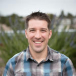
Photo of Tim FullmanGeographer Tim Fullman, senior ecologist with The Wilderness Society, is one of the people working to understand how to conserve the critical habitat on which caribou rely. Using analyses drawn from spatial and interdisciplinary sources, Fullman tracks and predicts herd patterns as they move over Alaska’s public lands. Much of his research focuses on the Western Arctic Caribou Herd (WACH), among the biggest of the state’s 32 caribou herds.
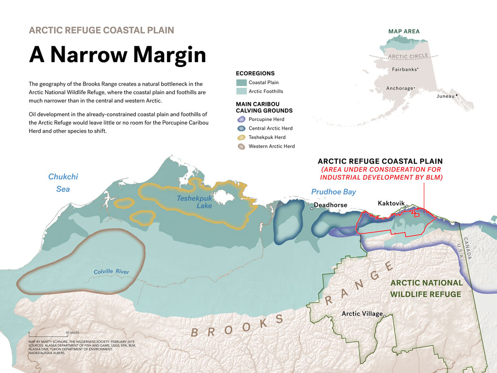
Arctic Refuge Coastal Plain: A Narrow Margin The geography of the Brooks Range creates a natural bottleneck in the Arctic National Wildlife Refuge, where the coastal plain and foothills are much narrower than in the central and western Arctic. Oil development in the already-constrained coastal plain and foothills of the Arctic Refuge would leave little or no room for the Porcupine Caribou Herd and other species to shift.
Arctic Refuge Coastal Plain: A Narrow Margin: The geography of the Brooks Range creates a natural bottleneck in the Arctic National Wildlife Refuge, where the coastal plain and foothills are much narrower than in the central and western Arctic. Oil development in the already-constrained coastal plain and foothills of the Arctic Refuge would leave little or no room for the Porcupine Caribou Herd and other species to shift. Map created by Marty Schnure


Fullman works alongside many partners, from Indigenous community leaders to hunters to tour guides to local, state, and federal wildlife and land professionals. All share a common cause: to preserve the future of Alaska’s caribou in the face of potential impacts from construction projects, energy investments, and climate change. The stakes are high. Alaska’s caribou, once totaling over a million, number 750,000 altogether today. The WACH, alone, has declined by as much as 50 percent since 2004.

In his work, Fullman spends a lot of his time using predictive models, forecasting potential impacts and scenarios that he says are also intimately connected to what we know about now and the past. “To do effective conservation means understanding the past so that we know why things are the way they are now,” he says, “and then using that information now to change the course of the future.”

Geography: The Critical Lens

Starting his career as a wildlife biologist, Fullman discovered that his fieldwork would benefit from an advanced understanding of terrain, place, and migrations. After completing a PhD in geography at the University of Florida, he returned to his work studying large herbivores, this time in Alaska. (Previous research had taken him to southern Africa, where he studied elephants).

Now, he says, his geography expertise takes people by surprise. “In my professional role, I don’t think many people know that I am a geographer, because my title is senior ecologist, and people think of me doing wildlife work,” he says. “Yet I’ve been fascinated as I’ve interacted with more people to come across a number of people with geography backgrounds who are doing work in landscape, ecology, environmental policy, and similar work.”

Why are so many geographers drawn to conservation—or rather, why are many conservationists drawn to geography? “This training seems like it has prepared a number of us to be able to make connections and share, and especially to use maps and other representations to talk about and communicate things in ways that connect with people.”

Geography’s interdisciplinary nature is also a plus: “One of the things that has helped me is that my geography department did not focus a lot on wildlife, but I had colleagues doing human dynamics, economic geography, all sorts of things that fall under the umbrella of geography. I think that prepared me to understand how social science is done, to understand how economics is done, and yet to see the connections where spatial processes and things that happen at space and scale and time influence across all these areas. I think of that as being at the core of geography and what we do.”
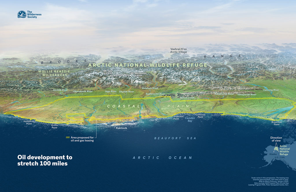
Birds-eye view of the Arctic National Wildlife Refuge coastal plain, known as the 1002 Area, outlined in yellow. This area, which is a critical calving and post-calving habitat for the Porcupine Caribou Herd, was leased by the Bureau of Land Management for its oil and gas program during the Trump Administration. Map created by Marty Schnure


Fullman applies ideas and methods from other disciplines to aid in his modeling work. One of these is circuit theory, adapted by ecologists from the world of electronics, which recently helped Fullman and his colleagues model the impacts of road construction on caribou and other species’ habitat. Another tool is the Monte Carlo simulation, used by Fullman and other researchers to test development restriction scenarios for the National Petroleum Reserve-Alaska (NPR-A): four from the Bureau of Land Management’s current Integrated Activity Plan, and one put forward by the Western Arctic Caribou Herd Working Group, to which Fullman belongs.

Map showing caribou seasonal ranges and proposed development projects created by Marty Schnure
Map showing caribou seasonal ranges and proposed development projects, created by Marty Schnure


Fullman’s training as a geographer has helped him embrace the many perspectives and complex realities of Alaskan habitats. In studying the ancient presence and fragile present of the caribou, he recognizes the long lineage and millennia-old knowledge held by the Indigenous communities within and around the NPR-A. As he brings new tools to the study of the herds, he embraces opportunities to learn and follow traditional ecological knowledge. “I am very classically trained as a scientist but yet through my time in Alaska, it has stretched my view,” he says. “What does it look like to meaningfully combine and blend all the ways of seeing the caribou?”

“Caribou Tell Us a Little Bit About Ourselves”

Fullman’s work contributes to understanding the pressure on caribou, which is part of a much larger and concerning trend of long-range and major migrations of all species—and humans.

“Caribou tell us a little bit about ourselves. They face some of the same challenges we do: warming climate, increasing development, and changing habitat – but with arctic temperatures increasing at double the rate of the rest of the planet, they’re feeling these challenges first,” says Fullman.

“Are we willing in any place to curb our desire to develop?” he asks “There are some places that are too important and too special.”

Find out more about AAG’s work to address climate change
    Share

Member Profile: Lesley-Ann Dupigny-Giroux

Map showing Arctic Refuge Birds-Eye-View program area created by Marty Schnure

The twice-annual migration of Alaska’s caribou is one of the world’s great journeys. Yet the number of caribou making that trek has been declining for decades due to a variety of factors, including habitat disruption from human activities and a changing environment.

Photo of Tim FullmanGeographer Tim Fullman, senior ecologist with The Wilderness Society, is one of the people working to understand how to conserve the critical habitat on which caribou rely. Using analyses drawn from spatial and interdisciplinary sources, Fullman tracks and predicts herd patterns as they move over Alaska’s public lands. Much of his research focuses on the Western Arctic Caribou Herd (WACH), among the biggest of the state’s 32 caribou herds.

Arctic Refuge Coastal Plain: A Narrow Margin The geography of the Brooks Range creates a natural bottleneck in the Arctic National Wildlife Refuge, where the coastal plain and foothills are much narrower than in the central and western Arctic. Oil development in the already-constrained coastal plain and foothills of the Arctic Refuge would leave little or no room for the Porcupine Caribou Herd and other species to shift.
Arctic Refuge Coastal Plain: A Narrow Margin: The geography of the Brooks Range creates a natural bottleneck in the Arctic National Wildlife Refuge, where the coastal plain and foothills are much narrower than in the central and western Arctic. Oil development in the already-constrained coastal plain and foothills of the Arctic Refuge would leave little or no room for the Porcupine Caribou Herd and other species to shift. Map created by Marty Schnure


Fullman works alongside many partners, from Indigenous community leaders to hunters to tour guides to local, state, and federal wildlife and land professionals. All share a common cause: to preserve the future of Alaska’s caribou in the face of potential impacts from construction projects, energy investments, and climate change. The stakes are high. Alaska’s caribou, once totaling over a million, number 750,000 altogether today. The WACH, alone, has declined by as much as 50 percent since 2004.

In his work, Fullman spends a lot of his time using predictive models, forecasting potential impacts and scenarios that he says are also intimately connected to what we know about now and the past. “To do effective conservation means understanding the past so that we know why things are the way they are now,” he says, “and then using that information now to change the course of the future.”

Geography: The Critical Lens

Starting his career as a wildlife biologist, Fullman discovered that his fieldwork would benefit from an advanced understanding of terrain, place, and migrations. After completing a PhD in geography at the University of Florida, he returned to his work studying large herbivores, this time in Alaska. (Previous research had taken him to southern Africa, where he studied elephants).

Now, he says, his geography expertise takes people by surprise. “In my professional role, I don’t think many people know that I am a geographer, because my title is senior ecologist, and people think of me doing wildlife work,” he says. “Yet I’ve been fascinated as I’ve interacted with more people to come across a number of people with geography backgrounds who are doing work in landscape, ecology, environmental policy, and similar work.”

Why are so many geographers drawn to conservation—or rather, why are many conservationists drawn to geography? “This training seems like it has prepared a number of us to be able to make connections and share, and especially to use maps and other representations to talk about and communicate things in ways that connect with people.”

Geography’s interdisciplinary nature is also a plus: “One of the things that has helped me is that my geography department did not focus a lot on wildlife, but I had colleagues doing human dynamics, economic geography, all sorts of things that fall under the umbrella of geography. I think that prepared me to understand how social science is done, to understand how economics is done, and yet to see the connections where spatial processes and things that happen at space and scale and time influence across all these areas. I think of that as being at the core of geography and what we do.”

Birds-eye view of the Arctic National Wildlife Refuge coastal plain, known as the 1002 Area, outlined in yellow. This area, which is a critical calving and post-calving habitat for the Porcupine Caribou Herd, was leased by the Bureau of Land Management for its oil and gas program during the Trump Administration. Map created by Marty Schnure


Fullman applies ideas and methods from other disciplines to aid in his modeling work. One of these is circuit theory, adapted by ecologists from the world of electronics, which recently helped Fullman and his colleagues model the impacts of road construction on caribou and other species’ habitat. Another tool is the Monte Carlo simulation, used by Fullman and other researchers to test development restriction scenarios for the National Petroleum Reserve-Alaska (NPR-A): four from the Bureau of Land Management’s current Integrated Activity Plan, and one put forward by the Western Arctic Caribou Herd Working Group, to which Fullman belongs.

Map showing caribou seasonal ranges and proposed development projects created by Marty Schnure
Map showing caribou seasonal ranges and proposed development projects, created by Marty Schnure


Fullman’s training as a geographer has helped him embrace the many perspectives and complex realities of Alaskan habitats. In studying the ancient presence and fragile present of the caribou, he recognizes the long lineage and millennia-old knowledge held by the Indigenous communities within and around the NPR-A. As he brings new tools to the study of the herds, he embraces opportunities to learn and follow traditional ecological knowledge. “I am very classically trained as a scientist but yet through my time in Alaska, it has stretched my view,” he says. “What does it look like to meaningfully combine and blend all the ways of seeing the caribou?”

“Caribou Tell Us a Little Bit About Ourselves”

Fullman’s work contributes to understanding the pressure on caribou, which is part of a much larger and concerning trend of long-range and major migrations of all species—and humans.

“Caribou tell us a little bit about ourselves. They face some of the same challenges we do: warming climate, increasing development, and changing habitat – but with arctic temperatures increasing at double the rate of the rest of the planet, they’re feeling these challenges first,” says Fullman.

“Are we willing in any place to curb our desire to develop?” he asks “There are some places that are too important and too special.”

Find out more about AAG’s work to address climate change
    Share

Member Profile: Trang VoPham — Understanding the Spatial Context of Cancer

Photo of Trang VoPham
Trang VoPham

Medical geographer Trang VoPham appreciates “the seamlessness between the disciplines” of geography and epidemiology, particularly in the application of geospatial methods, including GIS, to charting and confronting public health risks.

VoPham, who simultaneously pursued a Ph.D. in epidemiology and a masters degree in geospatial methods, now conducts research at the Fred Hutchinson Cancer Research Center in Seattle, Washington. Her focus is understanding the influence of environmental factors associated with place or location on the incidence of disease in humans. On any given day, VoPham might find herself mapping measures of air pollution, analyzing demographic data across census tracts, or reading the latest publications on cancer. 

Much of her recent research has been aimed at uncovering environmental factors associated with liver cancer. In the United States, VoPham notes that a high proportion of liver cancers are unexplained. Aflatoxins produced by different fungi are known to be important environmental causes of liver cancer in some parts of the world but there is an emerging awareness that chronic exposure to air pollution may also result in elevated risk. 

Because cancers result from complex interactions of genetic, behavioral, and environmental factors, VoPham’s work is highly interdisciplinary. For example, in a study funded by the Prevent Cancer Foundation, she is working with investigators with expertise in geospatial science, environmental epidemiology, and health psychology to provide participants with their own air pollution sensors and an associated smartphone app that visualizes air quality in their vicinity. 

During the study, the research group will provide participants with information about harmful health effects of air pollution and offer them general strategies and specific cues for reducing their exposures. In doing so, the research group aims to empower people with information to take control of their own health and then assess whether they act on that information.

When asked about the lessons of the COVID-19 pandemic for her own research, VoPham didn’t hesitate: “The COVID crisis has been a clear reminder to me of health disparities and the importance of addressing them in my work,” regardless of whether they are associated with geography, race/ethnicity, or some other factor.

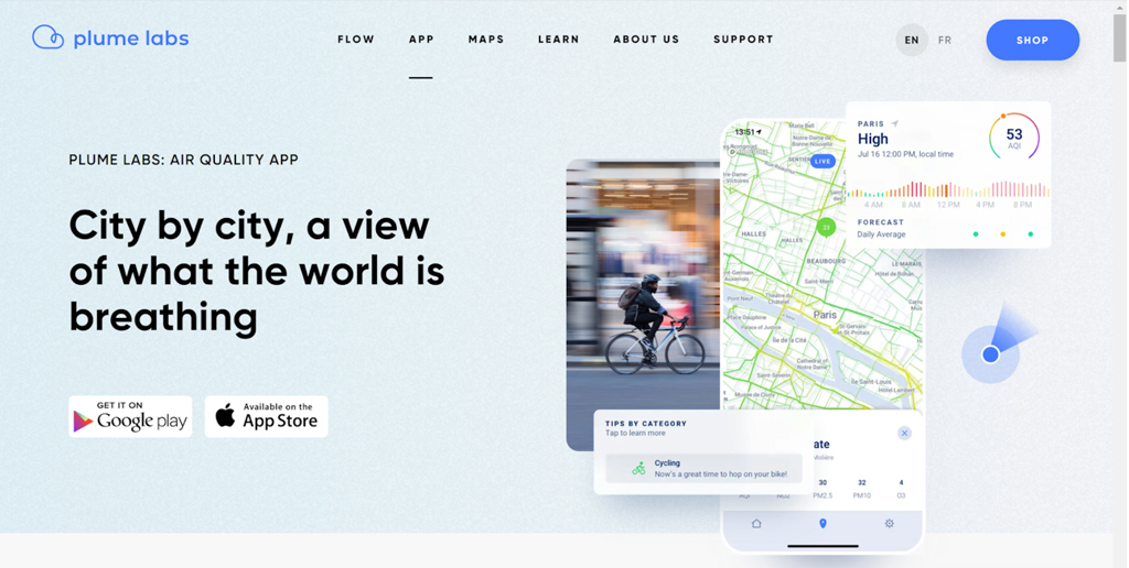
Screenshot of Plume Labs tool used by Trang VoPham
Plume Labs tool used by Trang VoPham
    Share

The Future Is Here: Sophia Garcia and the Intersections of GIS, Redistricting, and Social Justice

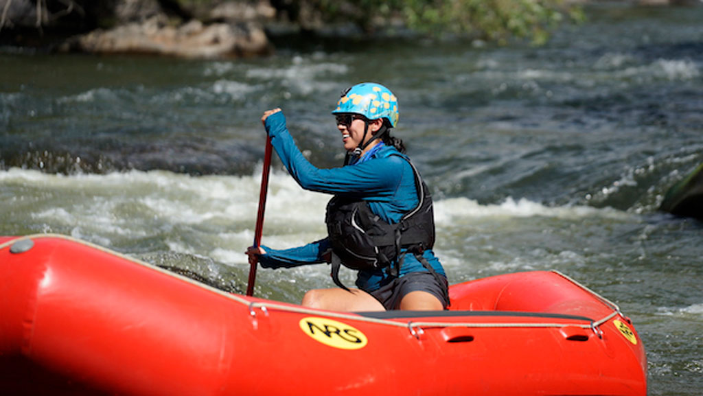
Photo of Sophia Garcia padding a raft in river rapids

We’re celebrating the accomplishments of geographers during Geography Awareness Week (November 14-20) and beyond. Find out more about this year’s theme, “The Future Is Here: Geographers Pursue the Path Forward” at our GeoWeek StoryMap, and follow the celebration at #GeoWeek or #GeoWeek2021.

Photo of Sophia GarciaSophia Garcia, the GIS and Outreach Director for Redistricting Partners in Sacramento, CA, understands how maps can start necessary conversations. In her current role, she sees redistricting efforts and community involvement as the “perfect intersection of talking about community, uplifting the community and letting them know what’s happening.” In her work she focuses on the imperative that we bring light to the redistricting process, engage communities, and empower them to get involved.

Garcia graduated with a bachelor’s degree in Environmental Studies from Wellesley College in 2015, and now works for Redistricting Partners from her base in Bakersfield, California. Garcia came to her current role from her previous work as a GIS Analyst for the Dolores Huerta Foundation, where she saw firsthand how she could uplift the work of her colleagues and community organizers through mapping. GIS software has great potential to start a dialogue and Garcia knows this:

Data is more than just numbers; there’s a story behind what’s happening.

Although she grew up with a father who worked in the GIS field (she attended her first ESRI User Conference when she was 10 years old, and mainly remembers the refreshments), Garcia did not see the full potential of GIS until college. Along with her classmates, she was tasked with figuring out how people living in a certain census block could do something sustainable surrounding food and grocery shopping. After knocking on doors and having conversations with people in the neighborhood, she found that not everyone had access to the nearest grocery store because of factors such as affordability, distance, and access to transportation.

Photo of Sophia Garcia padding a raft in river rapids
In addition to her work with GIS and redistricting, Sophia is a skilled rafter and rafting guide.


Because of the geographic nature surrounding the factors of access to food and sustainability, Garcia had an “aha moment” and realized the stories of everyone she had talked to could be conveyed using a map. She started to work with GIS on the project, and eventually went on to intern with the GIS departments in Kern County to learn more about the different ways that the departments utilized GIS.

At Redistricting Partners, Garcia has been very successful in using mapping technologies and outreach to emphasize the real-world implications of redistricting, and advocate for a more fair process. She was part of the group that sparked the passage of the California Assembly Bill No. 849, which mandates rules to increase transparency in the redistricting process in cities and counties across California. This bill, which Garcia hopes to see similarly implemented in other parts of the country, requires localities to have specific redistricting websites and mandates redistricting to be talked about during long public meetings, among other components.

When asked how younger geographers can explore new, interdisciplinary possibilities in geography, Garcia urges them to find a project they are passionate about and make use of mapping technology which is often available from ESRI to college and K-12 students. She recognizes that you can categorize pretty much any data geographically, and urges young geographers to “find whatever you’re passionate about, or mad about, or excited about, and learn to map it, make it as a poster, share it with someone, and you can have a discussion about it.”

    Share

A Day in the Life of a Geographer


    Share