New Orleans: The Uncertain City
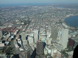
New Orleans battles with its identity. Locals see their home as a river city. Its European colonial founders etched a street grid across the narrow natural levee and perched the incipient city on the banks of the Mississippi River. Since then it has benefitted from waterborne commerce while battling high water that threatens its riparian site. The river loomed large in colonial life and looms large today.
Peirce Lewis, however, identified an uneasy relationship between the riverside site and maritime/inland hinterland situation when he labeled New Orleans as “the impossible but inevitable city.” The site on the banks of the river, had long been used by Native Americans as a strategic portage between the river and Lake Pontchartrain — in effect a bay of the Gulf of Mexico. The city’s French founder, Bienville, foresaw the importance of a city that could connect the vast North American hinterland with the Gulf and the French empire beyond. Indeed, colonial leaders abandoned two prior attempts to establish colonial capitals on the Gulf Coast before selecting the site about 100 miles upstream from the river’s mouth. Thus, the city is an heir of more direct coastal-oriented settlements, but reflects the significance of the river in its development. As the city celebrates it tricentennial in 2018, New Orleans may continue to see itself as a river city, but it functions very much as a Gulf Coast city on the banks of the Mississippi River.
Its relationship to the two water bodies remains thoroughly intertwined. In the years since 1718, the city’s economy has depended on the commerce coursing down the Mississippi – furs and cypress during the colonial era; corn, whiskey, hogmeat, sugar, and cotton during the antebellum period; grain and petrochemical products during much of the last century. New Orleans served as the entrepôt for this waterborne trade that relied on both the river and the Gulf. Another commercial tie has been tourism. Residents from across the Gulf South turned to New Orleans for a variety of pleasures since the 19th century, while New Orleans’s citizens have been prominent in the development of the Mississippi shore and visit the beaches of Alabama and Florida – furthering the city’s connections to the larger Gulf.
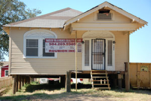
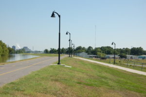
Coping with hazards also reflects the city’s position at the intersection of fluvial and marine environments. Flood control efforts have focused on protecting the city while diverting risk via engineered floodways onto coastal fishermen in Mississippi Sound and near the mouth of the Atchafalaya River. Tropical weather presents a powerful threat from the warm waters of the Gulf of Mexico, and with the loss of it coastal wetlands, New Orleans is ever closer to the Gulf and to storm surges driven by cyclones. After Hurricane Katrina in 2005, some homeowners reluctantly raised their houses on stilts, like beach houses – a concession to their coastal location. When the BP oil platform erupted in a tragic fire in April 2010 and released millions of gallons of crude into the Gulf, neighboring coastal states faced economic catastrophe as the slick washed onto their sandy beaches and drove tourists away. Florida’s governor criticized Louisiana for carelessly developing its offshore oil resources which he saw as a threat to his state’s economy. Residents of New Orleans complained that they could smell the oil from off shore – emphasizing their proximity to the Gulf.
Based on its role as entrepôt to the Mississippi River valley, New Orleans was among the country’s five largest cities on the eve of the Civil War. Levees obstructed the view of the river although they did not impede commerce, and these structures became one of the dominating features of the lower river landscape. The Civil War diverted Midwestern commerce to the eastern seaboard by rail, and New Orleans declined in the rank order of the country’s cities. The conflict also left the levees in a poor state of repair and a flood in 1874 provided a political tipping point in a long-running campaign to pass the costs of levee construction and maintenance to the federal government. At the urging of Southern planters and politicians Congress passed legislation in 1879 to fund and maintain the levees, not for flood protection of the recently rebellious region, but to maintain a navigable waterway for interstate commerce. By the early 20th century, engineers abandoned the mistaken belief that the river confined by levees would maintain a deep channel. Following several floods culminating in the most tragic U.S. flood on record in 1927, the Mississippi River Commission declared the main purpose of levees was to fend off inundation and not enable commerce. Despite the fact that the flood of record did not inundate New Orleans, it prompted massive re-engineering of the river that was oriented toward protecting New Orleans and its shipping interests. Its role as the entrepôt connecting the Mississippi River to the Gulf of Mexico remained a dominating concern.
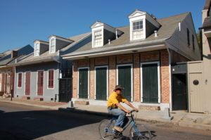
With its distinctive French and Spanish colonial heritage, a sizable number of African Americans, along with later Anglo, German, and Italian immigrants, New Orleans may have fallen in its ranking among the country’s largest cities, but it emerged in the 1800s as the largest Gulf Coast city of what Terry Jordan called the Creole Coast. With a legal system based on French civil code, a persistent French-speaking population well into the 19th century, culinary traditions from France, Spain, Africa, and indigenous populations, it became a most peculiar place. African and European cooks and chefs combined local seafood, rice, and spices from multiple hearths to fashion a creole cuisine that is a hallmark of the city’s culture today. Building traditions from Africa and Europe created a landscape unlike other American cities. Celebrations, most notably Mardi Gras, have incorporated elements of the Catholic sacred calendar with Caribbean and African influences to produce arguably the city’s best known spectacle each spring. In addition, Afro-Caribbean rhythms blended with European brass instruments to give rise to jazz.
One could argue that New Orleans thrives on these important elements of its past. Visitors flock to stroll through the narrow streets of the French Quarter, to sample the spicy creole fare, to enjoy the seductive rhythms and melodies in the jazz clubs, and to forget their cares along the parade routes during Mardi Gras. And beyond the well-worn tourist paths, there are countless lesser-known architectural, culinary, and musical treasures. Of course, the city is highly cognizant of its rich history and aggressively seeks to parley that into heritage tourism income. Indeed, in 2015 tourists spend over $7 billion dollars in the city. Tourism has largely recovered from the downturn after 9/11, the devastating decline caused by the hurricanes Katrina and Rita, and the Great Recession a decade ago.
Always looking for a way to expand its tourism calendar, the city supports numerous special events to attract visitors beyond the Mardi Gras season. The Jazz and Heritage Fest held each spring is one of the world’s premier music festivals. Operating since 1970, it began as a celebration of regional music — jazz, gospel, rhythm and blues, and Acadian sounds. It still features local talent and traditions, but has exploded into an international event drawing major popular music performers. There are countless other festivals — such as the Essence Music Fest, the Voodoo Music Fest, the Cajun and Zydeco Fest, the Satchmo Fest, along with Southern Decadence, the Creole Tomato Fest, the Oyster Fest, and the Oak Street Po-boy fest. Plus there are sports events such as the Sugar Bowl, the Crescent City Classic Marathon, and periodic NCAA championships. The annual calendar ensures that most visitors who stay even a few days will be able to participate in one of these celebrations. Indeed one the most noteworthy events will overlap with the AAG meeting in New Orleans — The French Quarter Fest.
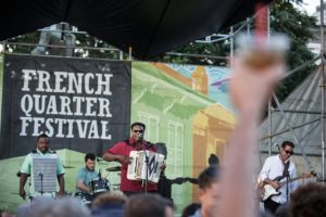
The French Quarter Fest was created to showcase local musical performers on multiple outdoor stages in and near the French Quarter. Initially, a “locals” event it offered free performances in the midst of the city’s historic district where local cuisine was available around every corner. It has grown but still offers a more intimate setting than that sprawling Jazz Fest, and admission is FREE. The festival’s web site [https://fqfi.org/] boasts that it will host 300 hours of entertainment by 400 performers during its run from April 12 to 15, 2018. It is truly one of the jewels of the city’s festival calendar, and it falls at a time when weather is generally quite pleasant and conducive to a street festival.
New Orleans has persisted in a perilous place for three centuries now and in that time it has given rise to a rich array of visual, auditory, and gustatory experiences. After the 2005 hurricane season, some questioned whether it made economic sense to rebuild the devastated city. Some 20 percent of the city’s population were not certain about the safety of returning and stayed away. Yet, rebuilding and denying risk, along with celebrating at the drop of a hat, are things that the people of New Orleans and the Gulf Coast excel at. Long-time residents are deeply attached to this quirky place, and new arrivals since 2005 came to get a taste of the traditions that endure, even if altered by the newcomers and their influences.
In the face of a disappearing coast, there is grave concern about the long-term future of the city and the outlying wetlands. Louisiana is investing huge sums of money to offset the encroachment of the Gulf across its coastal marshes. But with the highest rate of relative sea-level rise in the U.S., this deltaic coast will certainly change in the coming decades. How that will impact the city has yet to be seen and uncertainty hangs over the city like another layer of humidity. But we encourage you to come pay us a visit while you can.
— Craig Colten, Louisiana State University
Recommended reading, by geographers for geographers:
S. Hemmerling, Louisiana Coastal Atlas (2017)
A. Sluyter, C. Watkins, J. Chaney, A. Gibson, Hispanic and Latino New Orleans (2015)
R. Campanella, Bourbon Street (2014), Geographies of New Orleans (2006)
R. Orgera and W. Parent, eds., Louisiana Field Guide (2014)
C. Colten, Unnatural Metropolis (2005), Perilous Place, Powerful Storms (2009) USGS, Environmental Atlas of Lake Pontchartrain Basin
P. Lewis, New Orleans: Making of an Urban Landscape (2003)
Also visit the web page of the unofficial “Geographer in Residence” of New Orleans, Richard Campanella and his Geographer’s Space in the Louisiana Endowment for the Humanities’ Cultural Vistas
Also visit the web page of the unofficial “Geographer in Residence” of New Orleans, Richard Campanella and his Geographer’s Space in the Louisiana Endowment for the Humanities’ Cultural Vistas