Online Mapping with 4th-5th Graders / GIS and Public Health with 9th Graders in Georgia
 GeoMentor Volunteer: Brian Kaplan
Location: DeKalb County, Georgia
Grade level of participating students: 4th, 5th, 9th
Activity Theme/Focus:
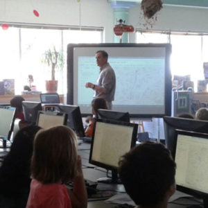
- 4th Grade: Geography, GIS, and Online Mapping with ArcGIS Online. Each student had a computer and I led them through an exercise. 4th grade was finding their home with their address, reviewing aerial imagery, panning and zooming the map. Finding directions from their home to school, reviewing the distance and travel time, comparing it to their known route, and creating a web application showing the terrain relief.
- 5th grade: We covered geography, GIS and Online Mapping with ArcGIS Online. Each student had a computer and I led them through an exercise of mapping the Underground Railroad.
- 9th grade: With the 9th Grade World Geography class I presented a 50 minute talk on geography, GIS and public health.
Number of Participants:
- 4th: Four classes with 22 students in each.
- 5th: One class with about 23 students.
- 9th: Four classes with 20 students in each.
How did you connect with your collaborator? For the 4th and 5th grade, I reached out and contacted the teachers. I have a daughter in 4th grade and through the librarian who I helped with other volunteer stuff discovered one of the 4th grade teachers was very interested in enriching her classes. I also knew the 5th grade teacher from my older child. I also started a conversation about online mapping with the librarian and a STEM coordinator who also spoke to the 4th and 5th grade teachers. For 9th grade, my daughter was taking her social studies class. I spoke to her briefly at the beginning of the year during an evening open house about my job and if I can help. And then she contacted me later in the semester about presenting. My daughter and the teacher also discussed it in class.
Describe your collaboration process: The collaboration process for 4th and 5th grade began in the spring semester when I stood up an ArcGIS online account for the school. The geomentoring didn’t go anywhere at that time. I spoke with the librarian 3 or 4 times for 10 or 15 minutes each and also the 5th grade teacher about 5 to 10 minutes once or twice all in the spring semester.
In the fall semester, the STEM coordinator and the librarian hooked me up with the 4th grade teacher during the school registration for fall and the discussions continued a few times for about 5-10 minutes when I came to school to drop off my daughter. I then gave two 30 to 40 minute lessons on ArcGIS online to the fourth grade teacher and that evolved into the Friday session for the students.
The plan for the 4th graders was hatched out of an idea I had for wrapping in their daily experience going to and from school.
The plan for the 5th graders was based on the 5th grade curriculum of the Civil War and the Underground Railroad. The teacher liked the geography mentioned in the song Follow the Drinking Gourd. I found material on the web (at NASA) that had the place information and coordinates for the song which we mapped.
Describe your tasks/involvement: I set up an ArcGIS Online (AGOL) organization account for my daughter’s elementary school. I then presented an AGOL exercise to 4 4th grade classes and to 1 5th grade class where all the students were on computers trying to follow along as I showed them the steps. I’m currently trying to create detailed instructions for the 4th grade exercise I presented. For my 14 year old daughter, I presented to my 9th grader’s world geography class on the GIS work I do at CDC.
What did you gain from the experience? What do you think the participants gained?
I gained a better understanding on the following (I still have more to understand):
- How better to teach a computer course
- How much material you can cover in 1 hour
- How better to teach GIS
- How to move slowly with teaching.
I also had a feeling of a great accomplishment for the effort and imparting GIS information to the kids and their excitement in the exercises.
For the 4th and 5th grades, I think my educator collaborators learned a lot about what GIS is and how to use it. I also think they now realize that there is much more to maps than the phone apps used for directions. We also learned how the students have a wide range of experience and a wide range of skills with computers. Some students lagged behind during the exercise while others sped through the material.
For the students, I think they had a great experience with the aerial imagery and what they can see from the sky. Plus how computer generated directions are not always accurate. The students were thrilled to see the elevation profile of their trip to school and the creation of a web app.
For the 9th grade educator collaborator, I think she learned how much effort goes into making the base maps used on phone apps and the different uses of maps in public health.Additional comments: Looking back I think I would review the available material again and perhaps do the training over two different days. The first day would be to familiarize the students with the ArcGIS online platform and the second day would be an exercise. The exercises I did find at the time did not interest me or were not specifically relevant to the 4th and 5th grade curriculum. Although this may have changed since that time.