Member Profile: Phoebe Lind
As a dancer and a geographer, Phoebe Lind’s career has been shaped by space and place. Most recently, her work as an enumerator for the U.S. Census Bureau, as a redistricting consultant for the Cook County Board, and as a recent graduate with a Masters degree in Geography and Environmental Sciences from Northeastern Illinois University, Lind has investigated the spatial relationship between environmental hazards and minority communities, and how they collectively inform the redistricting process.
I‘ve always really enjoyed the science behind maps: how they’re made, how projections work, the way that they can be incredibly insightful to spatial trends of where problems exist in the world.
“I think I changed career paths because the world really needs people studying environmental issues, learning how to sufficiently use this amazing GIS technology that we have today, to start to fix all kinds of complicated problems that we are dealing with.” Lind earned her bachelor’s degree in Dance before deciding to pursue a Masters at NEIU.
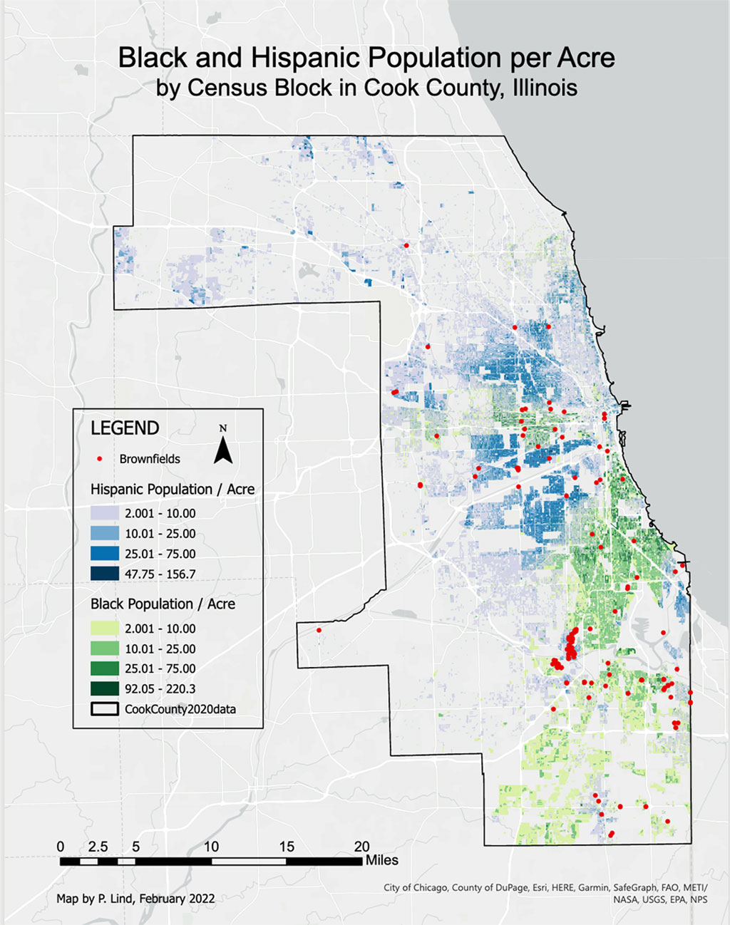
Lind’s academic research was inspired by a nationwide study that correlates the locations and traits of congressional districts relative to minority populations and Superfund sites. She decided to try to replicate the study herself, “or maybe develop a modified set of methods that could allow for this same study to be done on a county wide or similar scale, like a state or a city,” Lind explains, emphasizing the importance of scale. Lind’s own connection to the space she was studying—Cook County, where she lives—became clear as she moved through her research. “The reality for me is that I just have so much information on Cook County. And so much expertise on this redistricting process, because I did it. I did the redistricting process for this round of redistricting. I was an enumerator. I got to collect the data.”
Working on the ground as an enumerator in Cook County during the beleaguered 2020 census did a great deal to inform how she carried out her research. “I had no idea what that job would be like, and it felt like a historic opportunity to kind of jump in and see how the process went. I feel really lucky to have been the one helping. This is important demographic and population data for the country…and then being able to see the other side of that and having input on the redistricting process…it felt like a very important job.”
Are enough geographers in the room during the redistricting process? Lind thinks not. While processes differ from state to state, more geographers are needed everywhere to discuss the factors at play and help drive insights. “I think the redistricting process would benefit from more GIS data analysts, and geographers. Politicians may be great at what they do, but they could be missing a lot of things that matter in the redistricting process. GIS is great at pointing those things that seem invisible until you put the table of data on a map and point it out to them saying, ‘this is the data and this is what it looks like spatially.’”
When asked what she’ll do now that she has received her masters degree, she smiles. “I have a very nice problem where I’m interested in lots of different ways that I can use GIS…but since working with Cook County data, election data and election mapping have also been super interesting…I’m thinking I might want to go a little further with the study [I initiated], to see what I can change, what methods I can tweak. Maybe I can add onto it…because I think it has potential to grow a lot. But that’ll probably serve as kind of a side project to whatever job I end up doing, so the future is a little bit unknown. I’m pretty much just excited about GIS.”
Find out more about AAG’s initiatives toward Geography for Inclusion