Mapping chimps: Drones and the future of conservation
Chimpanzees are one of our closest cousins – and are at risk of extinction. Drone mapping is giving them another chance.
Professor Serge Wich, Dr. Alex Piel, Dr. Fiona Stewart and a team of PhD researchers from Liverpool John Moores University are working to save Tanzania’s chimpanzees. Their tools: homemade drones and Pix4Dmapper.
Since the project launched in 2012, Serge and the team have been working on a number of initiatives to support and protect the chimpanzees.
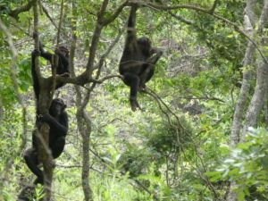
“Chimpanzees are so closely related to us,” explained Serge. “So if we are to unravel our own human ancestry we need to be able to study the species – if they go extinct then we definitely don’t have that opportunity anymore.”
As most conservation interventions come from government, the team is focusing on gathering high quality data on the number of animals, and feeding the information back to the government.
Up until the project launched, data was collected on foot, a time-consuming process – despite the fact that the forests and savannas of Tanzania are well known for having low densities of chimpanzees. Chimpanzees are always on the move to find food and “Over a year, they might cover fifty, sixty or even seventy square kilometers. That’s quite large particularly in this very undulating terrain. It’s a real challenge to study them in those areas,” says Serge.
“The main aim of the project is to create more efficient methods of obtaining the distribution and density of chimpanzees in these kind of habitats. These areas are very hilly and are very difficult to negotiate,” says Serge. “Plus some areas are not reachable by car, especially given that we do survey work over large areas. So if we can make a more efficient by using drones that would be really helpful.”