Leveraging Geographic Information to Combat Wildlife Trafficking
The AAG was invited to participate in the Workshop on Leveraging Geographic Information to Combat Wildlife Trafficking hosted at the Stimson Center in Washington, DC on October 23, 2017. The workshop was led by Michigan State University Professor Meredith L. Gore in partnership with the Department of State’s Office of the Geographer. This was the first event organized by this partnership and the AAG was invited because of our outreach capacity to the geographic community. Upcoming events will be scheduled to bring together different stakeholders, develop a more comprehensive strategy that leverages geospatially-enabled information and Geographic Information Systems (GIS), and help combat wildlife trafficking more effectively.
Wildlife knows no political boundaries and as a consequence poachers often trespass international borders to carry out their illegal activities. In turn, illegal products extracted from wildlife are often trafficked across borders or continents to satisfy international consumer demand. The complex supply chain for trafficked wildlife products touches multiple human, physical and political geographies. Aware of the geospatial nature of this issue, Sally Yozell (Stimson Center) asserted in her opening remarks that we cannot think about wildlife trafficking without thinking about geographic data.
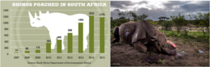
In 2015, the U.S. Agency for International Development (USAID) published a report on wildlife trafficking containing an assessment of the progress made since 2013, when President Obama created the Task Force on Wildlife Trafficking to create and implement a U.S. National Strategy for combating Wildlife Trafficking. At the workshop, Meredith L. Gore (MSU) and Lee R. Schwartz (DOS) shared some of the progress achieved with current strategies and challenges that still need to be addressed. The USAID assessment reports a decline in the elephant population of about 20% in the last decade and a decline in the rhinoceros population of about 5% in 2014 alone. One of their most successful operations so far, “Operation Crash,” led to the identification and prosecution of 30 individuals or businesses, which resulted in 20 convictions with sentences of up to 6 years and the seizure of 4.5 million U.S. dollars’ worth of illegal wildlife products. Although current strategies have helped, the progress is slow and insufficient in many cases. For example, since 2007 the poaching of rhinos declined for the first time in 2015, but only by about 3% from the year prior (see graph below). The 2017 Wildlife Photographer of the Year awarded by the National History Museum went to Brent Stirton, which he earned with a cheerless photograph of a poached Rhinoceros found in South Africa (see photograph below). This is the first year that the grand title prize goes to a photograph witnessing the suffering of wildlife rather than its beauty, which only hints at the magnitude of this problem.
One of the main objectives of the workshop was to deliberate a new strategy in which geospatially-enabled information can be leveraged to combat wildlife trafficking. Collecting geographic information and using GIS technology has proven effective in prior efforts. One of the guests, Drew Cronin, shared the effectiveness of the Spatial Monitoring and Reporting Tool (SMART), a free and open-source handheld GIS that allows rangers to collect and share geospatially-enabled data when they are in the field. SMART was developed thanks to a partnership between organizations that want to make conservation efforts more efficient. Using geospatial information collected in the field, hotspots of wildlife trafficking activity were mapped, allowing managers and governments to deploy rangers to target areas. Using this tool resulted in the apprehension and prosecution of 64 poachers in a reserve of the Democratic Republic of the Congo in 2014 alone and is now being used in several countries in Africa and Asia.
The workshop included many expert speakers and guests and discussions demonstrated some consensus on the development of a more comprehensive strategy to combat wildlife trafficking. More specifically, there was consensus on the value of collecting geospatially-enabled information and on the need to share these data between governments and organizations. Trust between governments and organizations is currently lacking however and sharing these sensitive data on the location of animals and/or individuals involved in illegal trafficking is risky. To that end, this new strategy will require stronger interdisciplinary and transnational collaborations and the development of a secure platform that facilitates the sharing of geospatially-enabled data.
This workshop was the first of a series of upcoming events around this topic. Future events include an Africa-based workshop in early 2018 to engage local stakeholders to refine and revise the strategy. If you are interested in receiving more information regarding these events, please contact Meredith L. Gore at gorem [at] msu [dot] edu.
Related resources and events resources:
- Summary report of the Workshop on Leveraging Geographic Information to Combat Wildlife Trafficking
- USAID assessment report on wildlife trafficking
- Combating Wildlife Trafficking Community of Interest (CWT COI)
- Geography 2050 conference discussion on Iconic Species Sharks, Birds, Elephants and Buffalo
- Pathfinder Magazine 2016 Vol. 14, Issue No. 4 focus on wildlife trafficking