Angel David Cruz Báez

Students, teachers and the community mourn the departure of Dr. Angel David Cruz Báez (1948-2024). His career was marked by a deep commitment to teaching and research, leaving a lasting impact on his students and colleagues.

Professor Cruz Báez was one of the first professors of Geography in Puerto Rico and served as a professor and director for more than 30 years in the Department of Geography of the University of Puerto Rico. Before this, he began his academic career as a professor at the Interamerican University in San Germán.

Dr. Ángel David Cruz Báez was a distinguished professor and director in the Department of Geography at the University of Puerto Rico, where he earned his bachelor’s degree. Dr. Cruz Báez’s research focused on various aspects of geography, including residential segregation by socioeconomic class, particularly in metropolitan areas like Miami. His work contributed significantly to the understanding of geographic and social dynamics in urban settings.

His achievements, beyond his publications, were to create a solid geographical community dedicated to teaching, research and the creation of a holistic local environmental awareness. Published books, articles and essays, since his dissertation at the University of Wisconsin-Madison, show great love, commitment and respect for Puerto Rico.

Throughout his career, he was known for his passion for geography, his dedication to academic excellence, and his efforts to promote knowledge about the geographic and social environment. Additionally, he was a leader in the management of geographical information systems, statistical applications, computer management and digital mapping in Puerto Rico.

He also forged several generations of geographers as an advisor, counselor, friend, teacher and mentor. His legacy continues to inspire those who had the privilege of learning from and working with him.

The loss of Dr. Ángel David Cruz Báez is deeply felt by all who had the privilege of knowing him. His passing is deeply felt in the academic community, but as we reflect on his life and contributions, we are reminded of the power of education to change lives and the importance of passionate educators like Dr. Cruz Báez who devote their lives to this cause.

Adapted from an online memorial on Facebook.

    Share

Student Resources

James Gordon Nelson

In May 2024, Canada lost one of its most distinguished and honored geographers, Dr. James Gordon Nelson, Distinguished Professor Emeritus of University of Waterloo in Canada.

Dr. Nelson was an internationally respected and renowned expert in conservation, protected areas, and policy, having worked all over the world, and was a leader as advocate for parks and protected areas all over Canada during a professional academic career that spanned decades. He received his B.A. from McMaster University, his M.A. from Colorado, and his Ph.D. from Johns Hopkins University. Before accepting a position with the University of Waterloo in 1975, Dr. Nelson held academic and administrative positions at the University of Calgary and the University of Western Ontario.

During his time in academia, he was a prolific scholar with hundreds of publications including dozens of peer-reviewed articles and several major authored or edited books — many with students and colleagues as co-authors. In addition, during his academic career at University of Calgary, Western University, and the University of Waterloo, Dr. Nelson advised and mentored dozens of graduate students — many of whom are today leaders in governmental agencies, NGOS, or in academia, continuing the legacy of his work. Although he retired from the University of Waterloo Department of Geography and Environmental Studies in 1998, he remained active working on book projects, with his colleagues including former graduate students. Notable publications include Protected Areas and the Regional Planning Imperative in North America: Integrating Nature, Conservation, and Sustainable Development (2003, Michigan State University Press); Places: Linking Nature and Culture for Understanding and Planning (2009, University of Calgary Press); and Amid Shifting Sands: Ancient History, Explosive Growth, Climate Change and the Uncertain Future of the United Arab (2022, Austin Macauley Publishers).

Dr. Nelson has been a member of the College of Fellows of the Royal Canadian Geographic Society, a committee member of the World Commission on Protected Areas of the International Union for Conservation of Nature and Natural Resources, a member of the National Executive Committee of the Canadian Parks and Wilderness, and Ontario’s Representative on the National Board of Governors of Heritage Canada. He has received many awards, including the first Natural Heritage Award in 1978, the Canadian Association of Geographers Award for Scholarly Distinction in Geography in 1983, the Massey Medal for the Royal Canadian Geographic Society in 1983, a Certificate of Achievement from the Grand River Conservation Authority in 1994, and the 1994 Environment Award for the Regional Municipality of Waterloo.

His loss is deeply felt by all who knew him. His legacy is one of intellectual curiosity, rigorous scholarship, and a deep commitment to the principles of ecology, geography, planning, and policy making.

    Share

Robert “Bob” Moline

The daily work rhythms Robert “Bob” Moline observed for nearly 40 years reflected a passion for landscape, weather, culture, and thinking about the human place in the environment. After teaching his 8:00 am meteorology class, Bob took his daily run through the prairie and forested landscapes of the campus arboretum. Then, it was time to print and post the daily upper air and surface weather charts, teach another class or two, followed by late afternoons spent listening to jazz at high volume while organizing his slide carousels for the next day. Bob Moline was a beloved professor and colleague and the guiding force in building both the geography and environmental studies programs at Gustavus Adolphus College in St. Peter, Minnesota. Although he passed away in January 2024, his influence continues to be felt through the thousands of people he inspired to pay careful attention to the skies, to the landscape, and to their place in the region and river basin.

Bob Moline, was born in Gary, Indiana and grew up on the Southside of Chicago where his dad was pastor of Gustavus Adolphus Lutheran Church. Bob graduated from Chicago’s Hirsch High School in 1951 and entered Augustana College in Rock Island, Illinois, where he majored in science and met his future wife, Janet Reedquist. After college he served in the Air Force from 1955-1959 as an instructor in the weather training program at Chanute Air Base in Illinois and then at Etain, France, where he taught meteorology and held the post of Chief Weather Observer. The experiences in the Air Force prompted Bob to pursue a career in teaching. When he and Janet returned to the United States, he began graduate work in geography at the University of Illinois.

As Bob was finishing his master’s degree in 1961, Gustavus Adolphus College was in the process of establishing a geography program. Bob’s alma mater, Augustana College, had established its geography program in 1949. Like Gustavus, it was affiliated with the Swedish-American Lutheran Church. A telephone call between the deans at Gustavus and Augustana identified Bob as a likely candidate, and an interview at the Conrad Hilton Hotel in Chicago led to a job offer. Soon Bob and Janet Moline were on their way to Gustavus Adolphus College in St. Peter, Minnesota, where he would spend the next 37 years teaching full-time, raising two children (Jeff Moline and Karen Wallin) and living out the remainder of their lives until Janet died in 1999.   For most of the years since that time Bob remained in St. Peter with his new wife Kay.

Sharing the basement of Old Main and later the Nobel Hall of Science with the lone geologist, Bob Moline set about building the geography department while working on his Ph.D. in geography at the University of Minnesota. Under the supervision of University of California-Berkeley-trained Ward Barrett, Bob completed his dissertation in 1969 on agricultural drainage of wetlands and shallow lakes entitled, “The Modification of the Wet Prairie in Southern Minnesota.”  This work led to two published monographs on public attitudes in water resources management. Bob’s long-term research passion was to update Jan Broek’s classic 1932 study of landscape evolution in California’s Santa Clara Valley to document the transition from prunes and cherries to microprocessors and computer software.

Bob’s teaching portfolio reflected his diverse interests: Meteorology, Water Resources, Cultural Geography, The American West, and a course whose title reflected the questions he cared most about: Environmental Attitudes and Landscape Change. Bob knew well the value of maps and the importance of field experiences. He curated the map collection at Gustavus Adolphus College, one of the largest map libraries in the country at a liberal arts college. Between 1974 and 1998 he led an annual January Term field course titled San Francisco: The City and Its Region. To bring the expansive western landscape into the classroom, Bob shot his photographs in side-by-side mode and equipped his classroom with side-by-side slide projectors operated in tandem. In recognition of his excellence in the classroom, Gustavus awarded Bob with the college’s Distinguished Teacher Award in 1987. In presenting the teaching award, a faculty colleague described Bob as evincing “enthusiasm from the heart, commitment to the land, and deep care for students.”

Bob Moline put his geographic expertise into practice by running a regional rain gauge network with local farmers and serving on the Minnesota state power plant siting committee, the River Bend regional planning organization, the Minnesota Water Resources Board, and the City of St. Peter Planning Commission. In the preamble to the city’s 1995 comprehensive plan Bob managed to quote Lewis Mumford, Michael Sorkin, and James Howard Kunstler.

Bob’s geographical fascination never wavered. He seemed to never not be a practicing geographer. His love of places and his deeply ingrained sense of the world as landscape were constants throughout his life. His family vacations, often road trips to the American West, were geographical field trips. Visitors to his house were met with walls covered in maps, each with beloved stories. Who could have much patience for faculty meetings when, out there, the landscape, even the most mundane, was waiting to be explored? Bob Moline’s legacy of service and endless geographic curiosity lives on through his many former students who have found positions in university geography departments, high school geography classrooms, city planning departments, and water resources agencies across the country. Bob is survived by his brother Norm Moline, professor emeritus of geography at Augustana College (Rock Island, Illinois), his spouse Kay, and children Jeff, Karen, and their families.

This memorial was prepared by former colleagues and family members Mark Bjelland, Robert Douglas, Jeff Moline, Norm Moline, and Anna Versluis.

    Share

Returning to Detroit: In solidarity and with care

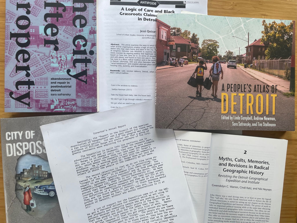
A photo of several papers and books about Detroit arranged on a desktop. Credit: Patricia Ehrkamp

Photo of Patricia Ehrkamp

After a 40-year hiatus, our Annual Meeting will be returning to Detroit, Michigan next March. The stack of Detroit-themed books and articles on my desk has been growing, and I am thrilled that the AAG will meet in this city again. Our long absence prompted me to briefly look back: We last met in Detroit in 1985 during the AAG presidency of Risa Palm, with 2,377 people in attendance. This may seem low given the size of more recent annual meetings, but the number of attendees amounted to roughly 44 percent of the AAG membership at the time. We were a much smaller organization then! As AAG Past President Risa Palm reminded me, the 1985 meeting was overshadowed by the University of Michigan’s decision to close their geography department only a little while earlier, which brought home the “institutional precarity of our discipline” (Huntley and Rosenblum, 2020: 367)—an ongoing concern for geography.

Like many deindustrialized cities in the U.S., Detroit has seen tremendous change since 1985, with shifts in its economic base, disinvestment, and serious population decline. In 2013, Detroit became the largest city in the US to ever declare bankruptcy. Since then, as you may know from U.S. media coverage, Detroit’s fate has changed. A recent example is the Ford corporation’s purchase and renovation of Detroit’s Michigan Central Station, which re-opened in June 2024. US media celebrate Detroit’s recent renaissance, including its renewed population growth after a decade of losses. More critical voices doubt, however, that all these new investments in the city, many of which come from outside, will benefit Detroiters. These are important concerns because “Detroit is continually rendered as a no-man’s-land and new frontier waiting to be claimed, tamed, and resettled” as Linda Campbell, Andrew Newman, Sara Safransky and Tim Stallman (2020: 11) write in A People’s Atlas of Detroit.

Our return to Detroit is in no small measure due to the advocacy of the Black Geographies Specialty Group (BGSG). As I learned during our preparations for the meeting in Detroit, BGSG urged former Executive Director Doug Richardson to hold another Annual Meeting there. “It is in the spirit of solidarity, academic intrigue, and social justice that we encourage you to select Detroit, Michigan as the host city for a future AAG Conference,” BGSG wrote in a letter[1] following the Boston AAG meeting in 2017. The letter emphasized that this majority Black city with its long history of activism and community organizing had long inspired important geographic research on race, ethnicity, and anti-Black racism–among others, the work of AAG Fellow and 2019 AAG Lifetime Achievement Award recipient Joe T. Darden.

Detroit, of course, holds a special place in the geographic imaginations of urban, radical and critical geographers because of the Detroit Geographical Expedition and Institute (DGEI), which was co-founded and co-directed by community organizer Gwendolyn Warren and geographer William (Bill) Bunge (1928-2013). DGEI operated from 1968-1972 with the goal to put geography to work in the interest of racial justice through community-based mapping and facilitating access to college education for Black Detroit youths. This work was possible with funding from the AAG. The re-release of Bunge’s book Fitzgerald: Geography of a Revolution in 2011 garnered renewed interest in the DGEI and Bunge’s work. Six sessions at the Annual Meeting in Boston in 2017 commemorated his contributions to radical geography, urban geography, and the quantitative revolution. At the 2014 AAG meeting in Tampa, two sessions focused on activist geographies and the legacies of the DGEI, including Gwendolyn Warren’s reflections in conversation with Cindi Katz (see also Warren, Katz and Heynen, 2019). This conversation challenged some of the myths in our discipline with regard to the DGEI that too often only focus on Bunge without fully understanding Warren’s role or acknowledging the important contributions of community research by “the Black people of Detroit.”

Given these complex histories, I hope that we will return to Detroit in solidarity and with care. This means “to take seriously the ways in which our work is “for others” and to build connection and responsibility as key values in our research approaches,” as AAG Past President Vicky Lawson wrote in 2007. It also means that we take seriously the city’s history and geography, and that we honor its residents’ experiences and visions for Detroit’s present and future. Recent work by geographers and others has taken on questions such as anti-eviction struggles (Quizar, 2024), property, displacement, and repair (Safransky, 2023), Indigenous and Black dispossession (Mays, 2022), and brought together community members, activists, and scholars to map and tell more nuanced stories of Detroit (Campbell, Newman, Safransky, and Stallman, 2020).

Returning to Detroit in solidarity and with care offers us an opportunity to pause and reflect on some of the historical erasures, silences, and exclusions in geography and in our professional organization, while also recognizing how much our discipline and the AAG have changed over time as we keep broadening the tent of geography. These changes are significant! I wrote about AAG’s commitment to advocacy, justice, equity, diversity, and inclusivity in my last column. But consider this: 40 years ago, there was no Black Geographies Specialty Group that could have advocated for a meeting in Detroit. Today, BGSG is a highly dynamic feature with a strong voice in the AAG and usually offers a curated track at our annual conference.

Holding a meeting in Detroit again—a city that has generated so much geographic interest and research—and returning there in solidarity and with care encourages us to make space for conversations about the future of geography, to collectively envision new geographic knowledges and practices, and—to borrow from Katherine McKittrick (2006: xv)—create more “humanly workable geographies.”  To me, this is what the meeting theme–Making Spaces of Possibility–is all about. As we have been planning the meeting, solidarity and care have already provided inspiration for several special sessions that will center research on Detroit and the wider region, and honor some of the contributions to geographic knowledge that have gone unacknowledged for too long. I hope that our annual meeting in the city of Detroit will be guided by “collective care—care for land, for relationships, and for people’s well-being” (Quizar, 2024: 802).

Our planning and preparations for the Annual Meeting is putting into practice solidarity and care through AAG’s commitment to a place-based approach to Annual Meetings. This includes putting together a series of webinars on Detroit and its surrounding areas, and creating opportunities for collaboration, volunteering, and learning in and from the city and region where we meet. Registration is open. I hope to see many of you there!

[1] The letter also listed the following supporters: Drs. Joe Darden & Alan Arbogast, Michigan State University Department of Geography, the Eastern Michigan University Department of Geography and Geology, the Geographies of Food and Agriculture Specialty Group, ACME: An International Journal for Critical Geographies, Journal of Social & Cultural Geography and Feminist Liberating Our Collective Knowledge (FLOCK), UNC — Chapel Hill.

References

Campbell, L., Newman, A., Safransky, S., Stallmann, T. (eds.) (2020). A People’s Atlas of Detroit. Wayne State University Press.

Detroit Geographical Expedition and Institute (1971). Available at https://antipodeonline.org/wp-content/uploads/2017/01/dgei_fieldnotes-iii_b.pdf.

Huntley, E. R., & Rosenblum, M. (2020). The Omega affair: Discontinuing the University of Michigan Department of Geography (1975–1982). Annals of the American Association of Geographers, 111(2), 364-384. https://doi.org/10.1080/24694452.2020.1760780#d1e244

Lawson, V. (2007). Geographies of Care and Responsibility. Annals of the Association of American Geographers, 97(1), 1-11. https://doi.org/10.1111/j.1467-8306.2007.00520.x

Mays, K. T. (2022). City of Dispossessions: Indigenous Peoples, African Americans, and the Creation of Modern Detroit. University of Pennsylvania Press.

McKittrick, K. (2006). Demonic Grounds. Black Women and the Cartographies of Struggle. University of Minnesota Press.

Quizar, J. (2024). A Logic of Care and Black Grassroots Claims to Home in Detroit. Antipode, 56(3), 801-820.

Safransky, S. (2023). The City after Property: Abandonment and Repair in Postindustrial Detroit. Duke University Press.

Warren, G. C., Katz, C., & Heynen, N. (2019). Myths, Cults, Memories, and Revisions in Radical Geographic History: Revisiting the Detroit Geographical Expedition and Institute. Spatial Histories of Radical Geography: North America and Beyond, eds. T.J. Barnes and E. Sheppard, Wiley: 59-85.


Please note: The ideas expressed in the AAG President’s column are not necessarily the views of the AAG as a whole. This column is traditionally a space in which the president may talk about their views or focus during their tenure as president of AAG, or spotlight their areas of professional work. Please feel free to email the president directly at [email protected] to enable a constructive discussion.

    Share

AAG Welcomes Summer 2024 Interns

Two new interns have joined the AAG staff this spring. The AAG would like to welcome Nora and Shayla to the organization.

Nora ButterNora Butter (she/her) is a junior at George Washington University pursuing a dual B.A. in Environmental Studies and Geography, with minors in Geographic Information Systems (GIS) and Sustainability. Her areas of interest include environmental justice, geomorphology, biogeography, sustainable city planning as well as mapping for representation and aid. In her free time, she enjoys attending concerts, baking, and musical theater. As an Ohio native that grew up in a car-heavy town, Nora enjoys exploring Washington, D.C. via public transportation and loves riding the metro. She’s excited for this summer and the research that follows!

Shayla Flaherty is a senior at Bridgewater State University, pursuing a B.S. in Geography with a concentration in Environmental Planning and Conservation. Her areas of interest include GIS, natural resource conservation, coastal zone management, and ecosystem ecology. Outside of academics, she enjoys painting, dancing, and golfing. She is excited to be working as the AAG’s Media and Communication intern.

If you or someone you know is interested in applying for an internship at the AAG, the AAG seeks interns on a year-round basis for the spring, summer, and fall semesters. More information on internships at the AAG is also available on the Jobs & Careers section of the AAG website at https://www.aag.org/about-us/#internships.

    Share

2023 Climate Change & Society Cohort

AAG Welcomes Jennifer Jones as New Membership Services Coordinator

Jenni JonesAAG is pleased to welcome Jennifer (Jenni) Jones as the newest addition to our staff as Membership Services Coordinator.

“I am looking forward to being a trusted go-to person for members once they do get to know me in the role,” Jones says. “The goal is to create an experience for the members that makes them want to stay members and also to tell other people about the benefits of being part of AAG.”

Jones brings 10 years of service experience working with numerous membership-based and public-serving non profits. Previously, she worked with the American Board of Internal Medicine (ABIM) as a credentialist and for the American Association for Cancer Research (AACR) as a program and editorial assistant in program development and publications.

Gaining an understanding of AAG’s history, committees, members, and offerings over the past few weeks is helping Jenni get a historical perspective on the organization, as she learns to resolve technical issues for members. As the membership services coordinator, Jones works to meet AAG’s programming and strategic planning goals, interacting with members to ensure needs are met and to participate in the initiatives and goals of the communities of practice, affinity, and specialty groups. “For now, it’s just digging in and learning all the ways in which everybody belongs to the AAG and the way in which people decide to interact with the organization because there’s many different ways,” Jones stated.

In her free time, Jones enjoys gardening and beautifying spaces, in addition to spending time with her cats, Vincent & Salvador. She also spends time in movement and organizing spaces for economic justice in and around Philadelphia, Pa.

    Share

A Toolkit for What Resists Fixing: Creating a Culture of Care

Person holding their hands in the shape of a heart with sunlight in background

By Risha RaQuelle, Chief Strategy Officer

Photo of Risha Berry

I most recently had the privilege of presenting a beta version of our TLC GRAM toolkit at the 2024 GFDA Department Leaders workshop with Dydia DeLyser of California State Fullerton and Daniel Trudeau of Macalester College. The TLC GRAM Toolkit is a compressed, operationalized approach to the AAG’s Justice, Equity, Diversity, and Inclusion Committee’s strategic plan. I was excited to share this newest version of the strategy, which we piloted with our JEDI Committee working groups, as a potential tool for geography departments and program leaders at a time when such tools are very much needed.

Briefly, I invited the participants to walk through the toolkit and consider their own justice, equity, diversity, and inclusion strategies in one of the seven domains: Training, (Focused) Listening, Communications, Governance, Reports, Advocacy, and Membership. Although created for use by geography education leaders, we hope that anyone could adapt these tools to a wide variety of settings. We have also taken care to prepare this for many contexts, knowing that some campuses and states are pushing back against JEDI programs in explicit ways. For program leaders in states where JEDI work is being challenged, the TLC GRAM framework provides a universal outline to consider how to do the work within these limitations, by emphasizing management and training approaches that have broad relevance for good governance and student support. For example, in the workshop, participants were invited to match existing and planned strategies with the TLC GRAM categories the activity aligned with.

This “inventory” approach is helpful for identifying a range of strategies and approaches that are already in place, viewing them through the lens of TLC GRAM “best practices,” and then identifying new methods they’d like to try.

The TLC GRAM inventory is a process designed to encourage leaders to identify and build on the JEDI practices they have planned or underway.

The TLC GRAM inventory is a process designed to encourage leaders to identify and build on the JEDI practices they have planned or underway. This approach also leads the participant to round out their JEDI practices by developing strategies within each of the seven domains of the toolkit. Through this process, a participant will begin to see opportunities for alignment, areas that overlap, and gaps in planning. When a team co-creates this list, it can be even more powerful, as they refine their brainstorming into clear and actionable steps, celebrating the opportunity to collaborate in accomplishing their identified aims.

In other words, the toolkit is designed to take the guesswork out of identifying the “perfect” strategy.

Why Seeking the “Perfect” Strategy is Not the Best Way

The request for a toolkit often comes with an expectation of highly specific steps to take, and this is understandable. Who wouldn’t want a quick and straightforward way to identify actions to take, find clear categories we can get right the first time, and co-create strategies that are seamless and efficient? However, a toolkit is just that: tools. Try as we might, we can’t make the tools themselves into the end. They are only the beginning of an intention toward change. Uncertainty, learning, trial and error are not only unavoidable, but necessary to facilitating change.

The work we do to intentionally create opportunities for systems change is not a short game. This work is deeply systemic, unpredictable, and requires long-term commitment. The temptation is to identify ALL the strategies that anyone has ever taken, listen to how they utilized them, and consider if those strategies may work in your own context. While there is value in considering many options, you as leader and your team are the best candidates for identifying what you want to accomplish and what might motivate you.

Knowing that this work requires patience, we can still motivate and energize ourselves by engaging in quick exercises to jumpstart our thinking.

Knowing that this work requires patience, we can still motivate and energize ourselves by engaging in quick exercises to jumpstart our thinking. Doing so allows us to become time delimited, listing activities that might be possible in each domain. Of course, fear and anxiety might emerge as the pressure builds to find the “perfect” strategy. The purpose of this exercise is to identify “a” strategy. Carving out 10-15 minutes together with your team will jump start a process to co-create and refine each strategy, as time permits. The goal is to see what might be possible. For example,

  • In the Training domain — I might want to identify what training courses are available to support faculty and staff or students in undertaking justice, equity, diversity, and inclusion work. An inventory of what exists in the department is a first step toward finding out who is already doing the work on our team. In states where constraints are being placed on many kinds of DEI programming, I might think creatively about ways to strengthen existing mentoring and leadership training programs and faculty development.
  • In the Focused Listening domain, a participant might say they will create opportunities to have discussions about a justice, equity, diversity, or inclusion strategy that the department might want to undertake. This could be during a staff meeting as a quick exercise. Again, this can take other forms, like a special listening activity for students to talk about their needs and experiences on campus. You could also regularly assess the departmental climate to ensure that it is ideally free of tensions and hostility and that it fosters a healthy, constructive and inclusive environment for all groups — students, faculty, and support staff.
  • In the Communications domain, one might identify who is represented on our website and why. Who is missing? Developing a strategy around gaining stories from scholars that you do not see on your website, personal testimonials, and narratives about their lived experiences in their research journey, could be a first start.
  • In the Governance domain, one might start with adding a justice, equity, diversity, and inclusion item (or a similar item focused on creating a culture of care, addressing full student needs, etc.) on every agenda to discuss opportunities for alignment and support. This way you will be certain to address this topic each time you meet.
  • In the Reports domain, you may want to identify what demographic reports exist for your department, who may have access to this and what might the trends be that you see as you disaggregate the data by demographic categories. You could also pair the demographic trends that you see with lived experiences of those that may not be represented in the data. What do we want to accomplish together and why, could be a first start.
  • In the Advocacy domain, you could identify what your advocacy aims are for your department, how you might support them and who might want to get involved.
  • In the Membership domain you might want to identify who makes up your department, team, or classroom, taking an assessment of who is missing and how you might find new opportunities to engage or recruit those that are not present.

While we can quibble over aspects of what is represented in the toolkit — and this matters — the first attempt is to take the first step, write something down and commit to doing the work. Pull the list together, with your team, co-create and consider the possibilities and limitations, with others, and start somewhere. You will be surprised at what you will accomplish when you take this first step. Please contact me so that we may celebrate your success. I am rooting for you!

Download the toolkit


The AAG Culture of Care column is an outreach initiative by the AAG JEDI Committee. Don’t forget to sign up for JEDI Office Hours. The current theme of Office Hours is An Ethos of Care in the Research Enterprise.

    Share

Tips on Future-Proofing Your GIS Career

Illustration of a group of red and white circles containing location arrows; Credit: Al Amin Shamim, Unsplash
Credit: Al Amin Shamim, Unsplash

By Rosemary Boone, Esri Young Professionals Network (YPN)

As GIS evolves toward web-based applications, the skills required for a successful GIS career are also changing. This article provides advice on how to future-proof your GIS career by continuing your skill development and through community engagement, mentoring, networking, and attendance at conferences. You’ll receive crucial resources you can leverage to become more connected to various GIS community groups and build your own online presence and reputation.

What does it mean to be a GIS professional of the future? This is a valid question, as the world of GIS is constantly evolving. As GIS moves more toward being web-based, the skills needed to be a marketable GIS professional are changing too.

As a Senior Industry Marketing Manager at Esri, and an Advisory Board member for the Esri Young Professionals Network (YPN), I was recently inspired by an Esri YPN webinar, titled Future-Proofing Your GIS Career: Essential Skills and Training for Success, to compile five important tips for future-proofing your GIS career.

1) Stay Connected after You’ve Graduated

Preparing for your future takes a variety of forms and formats. You can build skills with online courses, apply for a certificate in a specialized area, or present at a conference. An important part of your professional development is connecting with, learning from, and sharing with your peers and community groups

Here are ways to include connections and networking in your career development:

Get Involved in GIS Communities

Connect with community groups or networks such as Esri YPN, Women+ in Geospatial, local user groups, associations like URISAAAGWomen in GIS, and USGIF.

LinkedIn is an excellent platform to stay engaged. You can follow industry experts and learn from the content they create. Start with joining the Esri YPN LinkedIn Group.

If you are a GIS user, Esri Community is one of the largest online GIS communities and is a place to read blogs, ask technical questions, connect with users of GIS technology, submit ideas, and set up RSS feeds. Many Esri products, services, and groups have their own Esri Community space and blog.

Become a Mentor

The best way to grow is to teach someone else. Mentoring, whether formally through a program or informally as a colleague, can help not only the people you mentor to learn, but you as well. Find out if you are eligible to mentor in your department, or get connected with an organization with mentoring programs, such as The URISA Mentor Network, which takes applications throughout the year for both mentors and mentees.

Ethnically Diverse Geospatial Engagement (EDGE) came out with a Beginners Guide to Mentorship with EDGE. Women+ in Geospatial has a  mentor program that also reaches an international group. AAG members also can get access to a list of mentors that you can get connected with. (Email Mark Revell to learn more).

You can also browse through the YPN Mentorship space to read up on material and resources around the overall topic of mentorship.

Attend Conferences

Conference-going is a big way to grow your skills and network through attending presentations and workshops to learn about the latest technology trends. Many times, you will be introduced to a new concept or idea while at a conference to take back to your organization that could potentially result in a successful campaign or initiative. The contacts you make at conferences can be leveraged as a resource for future collaborations, troubleshooting, mentors, and potential colleagues.

Some conferences that may interest you include AAG’s Annual Meeting and check out Esri conferences.

2) Equip Yourself to Overcome Challenges

There will be a time where you lack confidence about learning something new when you begin your career. It happens to all and the best of us! Here are ways to approach that challenge when learning something new.

First, remind yourself, “everyone has been new at something once.”

Next, ask questions. It’s best to ask questions at the beginning to show you’re engaged and you’re thinking about the problem. If you feel nervous or confused about something that you might not have the skills to accomplish, know that asking questions is not considered a weakness.

Remember, it’s okay to say, “I don’t know”. Have the mindset to say, “I don’t know but I will figure it out” because chances are the resources are out there for you. When asking quality questions, you demonstrate a sincere thoughtfulness and a willingness to go deeper.

Last, don’t underestimate the knowledge that you do have. It’s important to sometimes take a step back to acknowledge how far you have come in GIS and learning ArcGIS. Imposter Syndrome is a real thing and can be easy to get caught up in.

3) Leverage Resources to Grow Your GIS Skills

There are many resources, both formal and informal, to help keep your GIS skills sharp:

4) Validate or Demonstrate Your GIS Skills

Showcase and validate your skills through programs such as the Esri Technical Certification Program and GIS Certification Institute. Achieving a certificate in GIS can elevate your professional standing and open doors to various career opportunities.

There are costs associated with each program. Esri Technical Certifications charges a fee for the exam, which is proctored online, allowing you to take it at home or in your office. GISCI charges for the exam and a portfolio submission, as well as small annual fees and recertification every three years.

Esri also offers free Massive Open Online Courses (MOOC) on various topics such as Spatial Data Science, Cartography, Imagery, Climate, and more. Each MOOC is six-weeks long and offers a certificate upon completion.

5) Build Your Presence and Reputation in the GIS Community

Sometimes, you just have to put yourself out there. There’s just no way around it no matter how uncomfortable it feels. This takes time, intention, motivation, and tenacity. (As I sit here and write this article, I too am putting myself out there!)

Here are some ways you can begin to build a presence and reputation of your own in the GIS community.

Become a YPN Ambassador

If you are just starting out as a GIS professional, the YPN Ambassador program could be a fit for you. YPN is designed to prompt you to network online and in person, developing professional communication skills and becoming an active participant in the GIS community. Complete the steps in becoming one of three ambassador types and earn your badge and certificate.

Participate in Mapping Challenges and Competitions

Virtual challenges, hackathons, and similar events are a fun way to attract attention and demonstrate your skills in geospatial technology. Some recommendations are:

Leverage Social Media to Boost Your GIS Career

Social media is a powerful tool for building an identity that aligns with your goals and values, enabling you to communicate and connect with the outside world, learn from others, cultivate creativity, and promote your work. By leveraging social media effectively, you can boost your reputation and visibility in the GIS community and establish yourself as an active participant.

Download this ebook, published in collaboration with the URISA Vanguard Cabinet and the Esri Young Professionals Network, to discover how to use social media to supercharge your career, leading to growth opportunities, meaningful connections, and collaboration prospects.

Join a Local YPN Chapter

Esri YPN has established seven chapters across the United States, each hosting two in-person meetups a year. Meetups revolve around networking, meeting industry experts, and learning the latest trends in GIS. Some meetups take place at an Esri regional office and vary in format such as geography trivia, demos, networking activities, and more. Join a chapter near you.

Find Guest Speaking Opportunities

Consider submitting a paper session or abstract to present at a conference. I took that advice and submitted a proposal for a lightening talk at the upcoming GIS-Pro conference.  To my amazement, I later received an acceptance email and will be traveling to present! Is this nerve-wracking and a bit uncomfortable for me? Yes! But I know that I will grow professionally as a result and meet people that will make me a stronger and more well-rounded professional.


Rosemary Boone is a Senior Industry Marketing Manager for Esri, concentrating on executing marketing strategies for K-12 schools and higher education institutions. She holds a master’s degree in education technology with an emphasis on multimedia. Prior to her career in marketing, she taught elementary school and taught overseas. In her free time, she likes to listen to music, exercise, and spend time with her two Dachshunds.

Featured Articles is a special section of the AAG Newsletter where AAG sponsors highlight recent programs and activities of significance to geographers and members of the AAG. To sponsor the AAG and submit an article, please contact Oscar Larson olarson [at] aag [dot] org.

    Share