PRESIDENT’S COLUMN
Making Data Meaningful Or Geography’s Contribution to Data Science
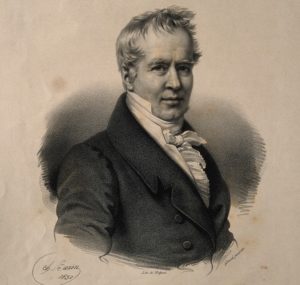
By David Kaplan
Geography has always been about data. After all, the field was founded and developed over the search for more and better information. It was 200 years ago that Alexander von Humboldt, perhaps the most famous geographer, acquired field observations in the Andes Mountains and used these observations to make a series of connections… Later—as geographers came to critically inspect the sources, meanings, and uses of information—data continues to be the engine of our discipline.
Continue Reading.
ANNUAL MEETING
Save the Date for AAG Seattle!

Join us for the 2020 AAG Annual Meeting April 7-11, 2021 both in person and virtually. We invite you to organize and participate in sessions, workshops, field trips, special events, and activities. Look for the call for papers in July 2020. We look forward to seeing you in the Pacific Northwest and online!
PUBLICATIONS
NEW GeoHumanities Issue Alert:
Featuring Articles that Engage with Literary Works, Address Climate Change, and Explore New Mediums
The most recent issue of GeoHumanities has been published online (Volume 6, Issue 1, June 2020) with 15 new research articles and creative pieces on subjects within geography. Several articles in this issue focus on the works of authors such as Anna Seghers, Barbara Kingslover, and Terry Pratchett. Other topics in this issue include television communities, human-wildlife relations, urbanization in Mumbai, the Personal Place Project, climate change risks, offerings at spiritual sites, and ethics in the geohumanities. Articles also explore mediums such as oral histories, testimony, theater, poetry, and artwork.
All AAG members have full online access to all issues of GeoHumanities through the Members Only page. In every issue, the editors choose one article to make freely available for two months. In this issue you can read “Forgetting the Stories Would Be Catastrophic”: Writing the Oral and Protecting the Place in the Poems of Temsula Ao and Esther Syiem by Sayantan Chakraborty for free.
Questions about GeoHumanities? Contact geohumanities [at] aag [dot] org.
 In addition to the most recently published journal, read the latest issue of the other AAG journals online:
• Annals of the American Association of Geographers
• The Professional Geographer
• GeoHumanities
• The AAG Review of Books
ASSOCIATION NEWS
AAG Commitment to Justice and Equity
AAG has issued a statement condemning the racism, violence, and systemic inequities that directly threaten the lives of Black Americans. Within our own community, we stand in support of Black geographers and geoscientists, who bear a disproportionate daily burden in confronting and fighting structural racism. We renew our commitment to actively combat oppression and support our members who challenge institutions to create a more just and inclusive society. We welcome your thoughts, feedback, and suggestions on how we as an organization can offer support. Contact us at feedback [at] aag [dot] org.
Celebrate Pride 2020: Join AAG’s Queer and Trans Geographies Specialty Group
The Queer and Trans Geographies Specialty Group (QTGSG) welcomes AAG members who identify as LGBTQ2IA+, whether or not your work touches on LGBTQ2IA+ topics. QTGSG is here to support and connect you to our community of LGBTQ2IA+ geographers in all the subdisciplines and all sectors. To find out more, follow @QTGAAG on Twitter, Instagram, and Facebook; or find the group in the AAG’s Knowledge Communities.
AAG to Hold Special Election to Update Conduct Policy
 In April, AAG formally adopted a revised Professional Conduct Policy, signaling an important benchmark in the work of the Harassment-Free AAG Task Force, AAG Council, and AAG leadership and staff. In order to include the provisions of the new policy in the AAG’s Constitution and Bylaws, members must vote on whether or not they choose to ratify the proposed changes. The special election will be held online between June 4 and 19, 2020. As in other elections, an electronic ballot will be emailed to all member’s current email addresses. Please ensure your email address is up to date to receive the ballot.
Read more about the proposed changes.
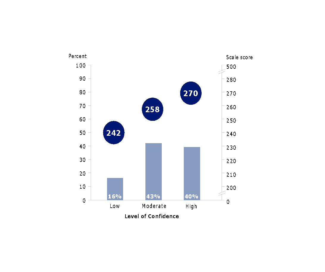
NAEP Geography Data Offers Research Opportunities
 The National Assessment of Educational Progress (NAEP) has released its most recent report card on geography education in the United States. The 2018 report card, with a representative sample size of 13,000 8th graders, provides insight into student achievement in a wide array of geographic content and skills. Senior Advisor for Geography Education, Michael Solem discusses the outcomes of the NAEP report and the questions it poses for researchers in geography education.
Learn more about the opportunities to use NAEP data.
Final Call for Submissions to the Guide to Geography Programs
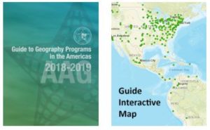 The AAG will continue to accept late submissions to the 2020 Guide to Geography Programs in the Americas through Friday, June 12, 2020.
Updated each academic year, the Guide lists undergraduate and graduate programs in all areas of geography and includes an interactive map that students can use to explore and discover geography programs, with easy-to-use search tools to find programs by degree type, region, and program specialization. It has long been an invaluable reference for faculty, prospective students, government agencies, and private firms in the United States, Canada, and throughout the world.
For more information and to list your program, please contact Mark Revell at guide [at] aag [dot] org.
POLICY CORNER
As States Reopen Amid COVID-19, Data Integrity is Key
 In response to his recent comments that a Florida Department of Health employee with a geography degree “isn’t a data scientist,” the AAG sent a letter to Gov. Ron DeSantis (R-FL) reminding him of the importance of geography in responding to the COVID-19 pandemic. These comments were made after the GIS manager at hand claimed her recent termination was the result of her refusal to manipulate state health data to reflect favorable conditions for reopening. Florida is not the only state that’s been called into question over issues of COVID-19 data integrity. Georgia, Pennsylvania, Texas, Vermont and others have been in the spotlight on issues ranging from accidental inconsistencies in calculations to perceived manipulation of the numbers.
With the U.S. unemployment rate hitting 14.7%, reflective of some 23.1 million people out of work, there is no doubt that Americans need solutions and resources to sustain themselves while the economy stagnates. But as we craft plans to send laborers and consumers back into the market, it is imperative to do so strategically and with the most up-to-date public health data available. We cannot let eagerness to resume everyday life preclude our capacity to contain the spread of the virus and to keep individuals safe.
The AAG recognizes that geographers and GIScientists continue to play a crucial role in the public health analyses that inform our urgent policy decisions addressing the COVID-19 crisis. It is up to our nation’s public officials to join us in upholding the highest quality of science and to subsequently act with the most accurate, transparent available data.
In the News:
- On May 21, Sens. Schumer (D-NY) and Young (R-IN) introduced the Endless Frontier Act (S. 3832), which proposes a new Technology Directorate at the National Science Foundation (NSF) and renames the agency the “National Science and Technology Foundation” (NSTF). The bill provides $100 billion over five years for research and development in 10 technology areas of global strategic significance.
- On June 3rd, Dr. Sethuraman Panchanathan’s nomination as next Director of the National Science Foundation was favorably reported out of the Senate Committee on Health, Education, Labor and Pensions. His final confirmation will be before the full Senate.
- The Census Bureau has released the first data from its new COVID-19 Household Pulse Survey.
MEMBER NEWS
Profiles of Professional Geographers
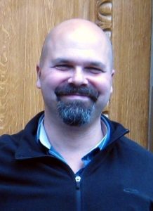
 “If you have a passion for a subject and a passion for mapping it, then you can be a geographer,” says Richard Quodomine, Senior Lead GIS Analyst, Department of Public Property, City of Philadelphia and this month’s featured Professional Geographer. Quodomine emphasizes that the ability to solve problems, a desire to learn new things, and clear communication skills are some of the best assets for a geography career. In terms of job growth, Quodomine thinks that the future is bright, especially for GIS work focusing on urban redevelopment, public safety, or climate change mitigation efforts.
Learn more about Geography Careers.
Update: Geographers respond to COVID-19
As many countries resume higher levels of activity, geographers continue to monitor the impacts of COVID-19 and draw out the lessons of the winter and spring.
 At Arizona State University’s School of Geographical Sciences and Urban Planning, PhD students Siqiao Xie and Yining Tan are working with professor Wei Li on a project entitled The Geography of COVID-19 and Asian American Vulnerability, Infection, and Anti-Discrimination and are adopting geographer Susan Cutter’s Social Vulnerability Index (SoVI) through a customization of the CDC’s SVI, using its four themes (socioeconomic, household composition and disability, minority status and language, housing type and transportation) and 15 variables, but crosstabbing each variable with Asian population. The illustration is a county-level map that illustrates the distinct spatial patterns between the two sets of SVIs (Asian specific v CDC general population). The project team then used the adapted SVI to explain the patterns of COVID-19 Asian infection and death data, and anti-Asian discrimination incidents. The team will now further examine whether such a method is applicable and can be generalizable among different vulnerable population groups.
Geographers continue to shape the public discourse on COVID-19. Brandi T. Summers, assistant professor of geography and global metropolitan studies at UC-Berkeley, wrote an op-ed for the New York Times on May 15 entitled Ahmaud Arbery, race and the quarantined city. In Buffalo, economic geographer Russell Weaver was interviewed by WSYR-TV in Syracuse about COVID-19-related unemployment: Newsmakers: economic geographer breaks down unemployment numbers. In St. Louis, Jerome Dobson and William A. Herbert offered Pandemic puts Americans’ patience, flexibility to the test. Bill Moseley, DeWitt Wallace Professor of Geography at Macalester College in Saint Paul, Minnesota, addressed global food security issues in a May 12 perspective in the World Politics review: The geography of COVID-19 and a vulnerable global food system.
Penn State’s geographers–both professors and alumni–are using geospatial data in several projects, from tracking disease transmission and allocating resources to prevent spread, to proactively assessing activity and mobility to address prevention.
Do you know about a geographer’s work to respond to COVID-19? Contact Lisa Schamess, AAG Director of Communications.
RESOURCES AND OPPORTUNITIES
Call for Nominations for AAG Honors, AAG Fellows, and Committees
 Please consider nominating outstanding colleagues for the AAG Honors, the highest awards offered by the American Association of Geographers, and the AAG Fellows, a program to recognize geographers who have made significant contributions to advancing geography. Individual AAG members, specialty groups, affinity groups, departments, and other interested parties are encouraged to nominate outstanding colleagues by June 30. Openings are also available to serve on either the AAG Honors Committee or the AAG Nominating Committee. Nominations of members who wish to serve on these committees are also due June 30.
More information about AAG Committees and Awards.
Call for Participants: AGI Study on the impact of COVID-19 on the Geosciences
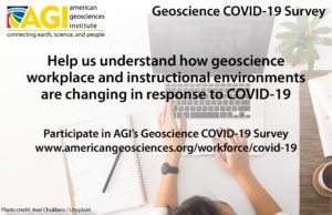 AGI is conducting a year-long study to understand how geoscience employers and educational institutions are changing their workplace and instructional environments in response to the COVID-19 pandemic, and to discover which of these changes will become permanent. This study is open to all geoscientists, including geoscience students, retired, and not currently employed, who reside in the United States, and are at least 18 years old. Over the next 52 weeks, AGI will email a brief online status survey twice a month to each participant, which will only take a few minutes to complete. The results of this study will be valuable in helping geoscience academic institutions, geoscience employers and decision makers to understand the structural impacts on the geoscience enterprise from the COVID-19 pandemic.
Learn more about participation in the study.
IN MEMORIAM
James R. McDonald
 James R. McDonald passed away on April 20, 2020. A proud 50 year member of the AAG, McDonald was a professor of geography at Eastern Michigan University from 1965 until his retirement in 2000. McDonald’s work specialized in migration, tourism, and environment assessment in Eastern Europe, predominantly France. In addition to publishing two books and numerous articles, McDonald was the recipient of research grants from the National Geographic Society, the Social Science Research Council, and the Michigan Department of Natural Resources.
Read more.
The AAG is also saddened to hear of the passing of Ron Johnston this past month with a written tribute forthcoming.
GEOGRAPHERS IN THE NEWS
EVENTS CALENDAR

“Now, because of AAG’s Bridging the Digital Divide Initiative, impacts of the global pandemic may better be met by our department in the months and even years to come….The gesture truly creates a win-win situation for Morgan State University, other HBCUs, and other minority-serving institutions invested in making geography an indispensable component of our liberal arts endeavors.”

Minority-serving institutions, including TCUs, are up against some of the biggest challenges we have ever faced. Although food security, financial stability, and academic preparedness are issues that the TCUs have always faced, COVID-19 has exacerbated those issues and also created additional concerns of isolation and lack of connectivity. With $10,000 from the Bridging the Digital Divide fund, we purchased laptops, webcams, wifi, Microsoft Office, and ArcGIS licenses. With additional funding, we could purchase more …”
 Geography has always been about data. After all, the field was founded and developed over the search for more and better information. It was 200 years ago that