Harley E. Johansen

Harley E. Johansen, Chair of the Geography Department at the University of Idaho for 30 years, will be both remembered for his scholarly work on rural development and departmental accomplishments which culminated in 2010 with the National Academy of Sciences ranking the graduate program among the top 20 geography doctoral programs in the nation, and as the top small department program.

He was born and raised on his parent’s dairy farm in Wisconsin, lived in state until the completion of his PhD from the Geography Department at the University of Wisconsin-Madison in 1974. He accepted a position at West Virginia University and in 1981 he was hired as Chair at the University of Idaho.

Harley proceeded to slowly and deliberately build the department, hiring new faculty, and over the span of his tenure encouraging the department to change and adapt with the times. He encouraged the early addition of GIS courses, adding support faculty necessary in that area, then the creation of the first Certificate Program at the university, which was in GIS.

The department had a Master’s Program when Harley arrived. He spearheaded the development of a PhD program which was reviewed and recommended by an outside committee of eminent geographers, and graduated its first PhD student in 1991. The next major shift in the department initiated by Harley was the hiring of physical geographers with a specific focus on climate change.

Harley’s own research work expanded geographically, though he remained rooted in understanding and expanding our knowledge of the process of rural development. Later his focus expanded to, at first, the Post-Soviet transition, and then most recently the impact of climate change on communities in the northern latitudes of Europe and Russia. In carrying out his evolving research agenda he was awarded a variety of grants over the years, notably nine from the National Science Foundation. Harley’s research and teaching was rewarded with four Fulbright Scholar or Senior Specialist Awards to Finland, Russia, and Macedonia. In Macedonia he developed a curriculum for a new university-level school in Skopje. He also conducted research in Denmark, Norway, Sweden and the Baltic countries, especially Estonia.

In 1984 he co-published a now classic book, The Changing Rural Village in America: Demographic and Economic Trends Since 1950 with rural sociologist Glenn Fuguitt, who had been one of his major PhD advisors at Madison. In 1987 he was the lead co-editor of the book Mineral Resource Development: Geopolitics, Economics, and Policy. He continued to publish book chapters and articles, individually and with colleagues, in diverse journals such as Annals of the Association of American Geographers, Business Geographics, Environment and Planning A, Eurasian Geography and Economics, Geografiska Annaler, Journal of Balkan and Near East Studies, Rural Development Perspectives, Rural Sociology, Western Wildlands and most recently Polar Geography in his expanding interests. Harley also attracted the attention of the international press for his work on the Post-Soviet transition and was invited to publish periodically in the Financial Times of London.

His most recent Barents Project initiated in 2012 was on climate adaption policies in Murmansk above the Arctic Circle, published in 2013 with Liza Skryzhevska in Polar Geography as “Adaption Priorities in Russia’s High North: Climate Change vs Post-Soviet Transition.” Harley believed strongly in field research and amazed us with the enthusiasm and obvious joy with which he would go to the coldest northern reaches of Norway or Finland in January or February, where he would drive around in a rental car interviewing people in communities undergoing climate change.

This past summer, even with illness, he joined another Finnish based group to do similar research for a diverse set of regions in Russia. A week before he died at 73 he was talking about developing another NSF grant and an article. Unfortunately, he contracted pneumonia when he was receiving treatment for myelodyplastic syndrome (MDS) after having had a full bone marrow transplant in Seattle, and for which he was dealing with myriad after-affects.

He is sorely missed by his colleagues, students and a multitude of friends around the world. There will be special sessions at the Chicago AAG meetings this April in his honor. Harley is survived by his wife, Nancy; his sister, Amy; his brother, Harry; his son, Peder; his daughter, Ingrid; and his young granddaughters, Johanna and Klara.

This article was reprinted with permission from the Department of Earth and Spatial Sciences, University of Idaho. 

    Share

Florence M. Margai

The sudden passing of Florence M. Margai on January 8, 2015, is of great sadness to the AAG and the geography community. She was a great advocate for the use of geographic data and tools to identify and address health issues.

Margai was born and raised in Freetown, Sierra Leone. She graduated with a BA in Geography from Fourah Bay College in 1985 then moved to the US where she earned a MA (1987) and PhD (1991) in Geography from Kent State University, Ohio.

From 1991 to 1994 she taught in the Department of Geography and Geological Sciences at Hunter College. She then moved to the Department of Geography at Binghamton University. In addition to her active involvement in the department, she served as an Associate Dean since 2011 and Interim Director of the Institute of Global Cultural Studies since 2014.

Margai’s research and teaching centered around the Geographies of Health, particularly health disparities, environmental hazards, and environmental justice and equity. She also maintained an active interest in Africa, particularly her home region of West Africa.

The focus of her work was applied, utilizing geographic data and technologies to understand the spatial distribution of health disparities, particularly within marginalized communities, women, the elderly, and children. Research studies included malaria morbidity and treatment in West Africa, childhood health in Burkina Faso, linkages between lead poisoning and learning disabilities in US cities, and the distribution of hazardous substances in low-income and minority communities.

She also worked with several non-profit organizations in the US and Africa on the geographic targeting of vulnerable population groups for disease intervention and health promotional campaigns.

Margai’s extensive publication record included three books, the most recent of which was Environmental Health Hazards and Social Justice: Geographical Perspectives on Race and Class Disparities (Earthscan 2010). She also served as editor of the African Geographical Review.

She was actively involved in the AAG since becoming a member in 1987. Her contributions included serving as Chair of the African Specialty Group, organizing the first Race, Ethnicity, and Place Conference, and running one of the My Community, Our Earth workshops in Ghana in 2013. In 2014 she was elected to the Council and we were looking forward greatly to her further contributions to the work of the Association.

Florence leaves behind a husband, William, and two daughters, to whom we extend our most sincere condolences.

    Share

Justice and Place

In this forum and with this audience I doubt that it will be at all controversial to state that justice and place are intimately connected. After all, geographers are typically quite aware of such relationships. Or at least one hopes that they are typically quite aware of this. The dynamics between geography and justice is readily apparent in a wide array of situations, from the segregation policies of the old American South to the occupation policies of Israel vis-à-vis Palestine to the variance in death penalty laws among the various states in America. What is amazing, though, is how often issues of justice and place appear in the news as well as in cultural products and how just as often they are not recognized as such by the majority of people or, perhaps, even by the majority of geographers. My best supposition of why this is so is that geographical connections become obscure and opaque as readers and viewers pay attention to what may seem like more immediate factors, such as the glaring inequities of injustice or the seemingly random enactment and enforcement of laws. However, a simple analysis of a small sample of items will demonstrate that the link between geography and justice is extremely dynamic and must be taken into account for even a superficial understanding of most events.

For example, if we open up the New York Times of December 19 2014 to page 20, we will find three separate stories that show completely different yet equally taut relationships between geography and justice. The first story is titled “2 Neighbors of Colorado Sue over Marijuana Laws.” Upon perusing this article, we discover that the States of Nebraska and Oklahoma are suing the State of Colorado, which recently passed a law legalizing marijuana. Nebraska and Oklahoma are basing their cases on a worry that the pestilence of pot will spill over their borders and cause havoc in their territories. Here, we obviously have an issue with a geographical turn to it, for if there were no states and no borders between them, then this would not be an issue at all and, thus, not a story. But it seems to me that most readers will go through this story without realizing that the connection between geography and justice is the prime element in this article, as that link is so obvious that it is masked, hiding in plain sight, as it were.

The second story is titled “Contesting Traffic Fines, Missouri Sues 13 Suburbs.” Here, we have the attorney general of the State of Missouri suing thirteen St. Louis suburbs for allegedly profiteering off of minorities and the poor by overzealous enforcement of parking fines and traffic violations. So instead of co-equal entities such as states going to battle, as in the first story, we have here a state turning its jurisdictional focus on smaller entities, municipalities within that state. Again, a clear geographical focus is paramount in this case, as it is only through the organization of the states and municipalities and their court systems along geographical lines that such a suit could even be filed. But, once again, geography as such is lost here as attention is shifted to the alleged injustices which the governments of the various St. Louis municipalities perpetrated upon their citizens.

The final story on page 20 of the December 19 edition of the New York Times, “Shooting Spurs Debates Over Race and Guns In a Gingerbread Town,” concerns a Muslim woman, Mary Araim, who had been sworn in as a U.S. citizen just days before she was shot and killed in the German-themed tourist town of Helen in White County, Georgia, by one Glenn Lampien. Here the geographical locus is a bit more complicated. First, we have a Georgia town which , for touristic purposes, presents itself as a simulacrum of a German village replete with such establishments as the Hansel & Gretel Candy Kitchen, Lindenhaus Imports, and the Old Bavarian Inn. Ms. Araim, a native of Iraq, where she had been a teacher and an assistant principal, had moved to the United States and settled in Houston. She was in Georgia to visit relatives in nearby Lawrenceville and was wearing a headscarf when she was walking down the streets of Helen where she was killed. Lampien of Jasper, Georgia, was in Helen seemingly to become intoxicated. He had been drinking in a local bar, King Ludwig’s Biergarten, before he ducked out on the bill and then allegedly shot and killed Ms. Araim. According to the article, Lampien contends that he shot his gun accidentally and that in no way did he target Ms. Araim because she was Muslim and wearing a headscarf. So perhaps here we could draw lines of destiny and fate between Iraq, Texas, and Georgia to delineate the lineaments of geography in this case. The extra factor of the German touristic layer adds a surreal plane to the mix, giving the tragic death of Ms. Araim a bizarre quality. We could also add in the fact that Ms. Araim was more liable to be shot in the United States than in almost any other country, including perhaps even Iraq, given our penchant for weapons and our lax laws regarding the purchase of ammunition and guns, and especially in states such as Georgia, which passed a law in March allowing gun owners to carry their weapons in bars, restaurants, churches, schools, and restaurants.

A quick look at a selection of classic plays and movies also yields a sampling of cultural documents reflecting a tight connection between geography and ethics. For instance, Shakespeare’s King Lear hinges on the division of Lear’s kingdom into three equal parts which he bequeaths to his three daughters. The geographical backdrop of the play is quite explicit as in Act One, Scene One, Lear declaims to his children:

Give me the map there. Know we have divided
In three our kingdom; and `tis our fast intent
To shake all cares and business from our age,
Conferring them on younger strengths while we
Unburthen’d crawl toward death.

Obviously geographical in nature, this passage even refers to the paramount technical instrument of geography, a map. The consequences of Lear’s recklessly fateful decision ends up casting Lear and his youngest daughter, Cordelia, against his other two children, Goneril and Regan, in a pitched battle over territory, authority, and familial devotion or the lack thereof. Yet here as well, the salience of geographical concerns gets lost amidst what seem to be more significant psychological and metaphysical issues. Lear tips towards madness and plumbs the depths of the geography of the Inferno: “Beneath is all the fiends. There’s hell, there’s darkness, there’s the sulphurous pit; burning, scalding, stench, consumption. Fie, fie fie! pah, pah!” But the linchpin and the catalyst of the tragedy is that geographical parsing out of his kingdom to his daughters, the division of territory leading to all that ensues in Shakespeare’s drama.

One of Hollywood’s most celebrated classics, A Wonderful Life, directed by Frank Capra, is also centered on quite obvious geographical concerns. In this rather smaltzy yet still powerful drama, George Bailey, played by the always earnest James Stewart, struggles to keep his hometown of Bedford Falls and his housing development from falling into the evils clutches of Henry Potter, played by a very creepy Lionel Barrymore. The story is all geography through and through, with opposite versions of the town, Bailey’s idyllic Bedford Hills versus Potter’s satanic Pottersville, set against one another, the former a blissful vision of an almost communal-like Americana suburb, the latter reeking with every form of degeneracy and sin. Of course, this being a Hollywood picture, Bailey wins out in the end but not before receiving a copy of The Adventures of Tom Sawyer from his guardian angel, Clarence, thus tying Bailey into the great mother of American rivers and therefore connecting the film to a geography (and a history) of a more expansive kind.

These examples of the importance of geography in cultural products are not singular: there are scores of others which could just as easily prove the point. For instance, Chekov’s The Cherry Orchard concerns the estate of a family of aristocrats turned over to member of the noveau riche, while Ibsen’s The Enemy of the People focuses on the polluted waters of a spa. Or consider the Oscar winners for best picture in the last two years. In 2013, the Oscar for best picture went to 12 Years A Slave while in 2012 Argo received the nod. Both movies are framed by a strong geographical context, with the former set in the South when the mode of production of slavery was dividing the United States in two and the latter having much to do with borders, nation-states, and attempts to transcend those borders through subterfuge and cunning.

My point here, though, is not to insert geography into various things, as if draping our discipline about the necks of this or that entity, but to demonstrate that geography is pervasive, especially in terms of the realms of justice and ethics. Where you are makes a great difference, in fact as well as in fiction. That we as geographers should be especially aware of this seems to be the least we can demand of ourselves.

—Rob Sullivan

DOI:10.14433/2015.0003

    Share

AAG Distinguished Scholarship Honors: Anthony Bebbington, Ruth DeFries

The 2015 AAG Distinguished Scholarship Honors is presented to Dr. Anthony J. Bebbington and Dr. Ruth DeFries.

Bebbington will receive this award for his exceptional record of scholarly achievement and policy relevance in the fields of development studies, natural resource management, and sustainable livelihoods.

DeFries is being recognized for the contributions that she has made to our understanding of the patterns and impacts of anthropogenic landscape change, and for her ability to link that research to larger international policy discussions aimed at reducing greenhouse gas emissions from tropical deforestation.

Citations for Anthony J. Bebbington and Ruth DeFries follow. 


Anthony Bebbington, Clark University

Bebbington

Dr. Anthony J. Bebbington is awarded the Association of American Geographers 2015 Distinguished Scholarship Honors for his record of achievement in development and environmental studies especially his path-breaking research on natural resources, poverty reduction, livelihoods and sustainable development in the Andes and beyond, and its recognition by policy makers and practitioners of development.

This recognition is most evident in his election to the National Academy of Sciences in 2009, a rare tribute to a relatively young scholar. Bebbington is noted for his interdisciplinary approaches in the fields of development studies, political science, economics, agriculture science, and geography. His research has contributed to the understanding of sustainable rural development, natural resource management, poverty, and social movements such as indigenous and grassroots organizations, especially in Latin America and the Andean region. He has combined extensive fieldwork in Peru and Ecuador, with institutional analyses to promote the understanding and respect of farmers and indigenous knowledge, the role of non-governmental organizations, the value of social capital to development, and the agency and empowerment of people and communities in the developing world. Bebbington’s publications include more than 20 edited or co-authored books, many in Spanish, and numerous journal articles and book chapters such as highly cited papers in World Development, the Annals of the AAG, and Economic Geography.

In addition to his experience in academia, his work informs economic policies in international development agencies such as the World Bank, the CGIAR, and the United Nations Food and Agriculture Organization. These applied aspects of his work have fueled his ability to engage in both applied and theoretical approaches with indigenous groups, as well as global development programs.

Bebbington has taught geography and development at the University of Manchester and the University of Colorado at Boulder, and he is currently Director of the Graduate School of Geography at Clark University. He has supervised a large number of graduate students who have gone on to careers in academia, NGOs and government. His scholarship and policy insights have also had influence through his work with the World Bank, the International Institute for Environment and Development, and the Overseas Development Institute.

It is with great pleasure that we recognize Dr. Bebbington’s extensive and profound contributions to the fields of geography and development studies more broadly.

Ruth DeFries, Columbia University

DeFries

In recognition of the significant and extensive contributions that she has made to our understanding of the impacts of anthropogenic landscape transformation on climate, biogeochemical cycling, and biodiversity, Dr. Ruth DeFries is awarded the 2015 Association of American Geographers Distinguished Scholarship Honors.


DeFries is currently Denning Professor of Sustainable Development at Columbia University. Prior to joining Columbia in 2008, she was professor in the Geography Department at the University of Maryland, served as senior project officer with the Committee on Global Change at the National Research Council (NRC), and taught at the prestigious Indian Institute of Technology in Mumbai, India. She received her Ph.D. from the Department of Geography and Environmental Engineering at Johns Hopkins University and her B.A. in Earth Science, summa cum laude, from Washington University in St. Louis, MO.

Driven by losses due to expanding human infrastructure, timber harvesting, resource extraction, and agricultural activities, habitat conversion remains the leading threat to global biodiversity. DeFries is credited with transforming the way that scientists track and analyze changes to the planet’s vegetation through the use of satellite imagery, which can cover large areas at repeated time intervals. Landscape transformation may, however, have far reaching impacts beyond the direct conversion of species habitats. Research conducted by DeFries emphasizes the intersections among land use, agriculture, climate and conservation throughout the tropics, with a focus on the Amazon and India. In particular, her work has illuminated the widespread consequences of changing the extent and pattern of Earth’s vegetation, including the effects on emissions of greenhouse gases that cause climate change, the loss of habitat for other species, and the potential movement of disease vectors.

Throughout her career, Dr. DeFries has published over 120 refereed journal articles and book chapters. These have appeared in many of the top journals in the world, including Science, Nature, Proceedings of the National Academy of Sciences, Nature Climate Change, PLos One, Global Change Biology, Remote Sensing of Environment, Ecology and Society, Journal of Biogeography and Conservation Biology, among many others. In recognition of her achievements, she was elected to the U.S. National Academy of Sciences in 2006 and the American Association for the Advancement of Science in 2008. She is also a fellow of the Aldo Leopold Leadership Program, the Ecological Society of America, and the American Geophysical Union, and she has received fellowships from the MacArthur Foundation and the Fulbright Program. She is a lead author on the Intergovernmental Panel on Climate Change (Fifth Assessment) and a member of the NRC’s Board on Environmental Change and Society. She is also a former Chair of the NRC’s Ecosystems, Land Use, and Biodiversity Panel of the Decadal Survey for the Earth Sciences, Vice-chair of the NRC’s Committee on Earth Studies, Space Sciences Board, and member of the NRC’s Committee on the Assessment of NASA’s Earth Science program.

    Share

Chicago’s Asian Cultures

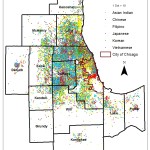
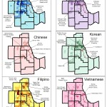
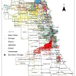
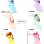
The Association of American Geographers (AAG) will be holding its next annual meeting April 21-25, 2015, in the American business hub city of Chicago, which can be reached by a direct flight from Beijing, Shanghai, Hong Kong, and many other major Asian cities. It is little wonder that many Asian cultures feel at home here in America’s heartland global city. On December 19 2014, the “25th U.S. – China Joint Commission on Commerce and Trade” concluded in Chicago. The Chicago Tribune reported that Beijing economic development official Cheng Yuhua expected a dingy industrial city, but the real Chicago surprised her: “What I’ve seen here – it completely changed my mind, the city looks young, it’s full of energy (Chicago Tribune, 21 December 2014).” Although the meeting was focused on U.S. trade, local Chicago got a fair bump in marketing itself as a global city open to foreign investment.

Asians in Chicago

In this newsletter article I will describe the residential patterns of six major Asian immigrant groups – Asian Indians, Chinese, Filipinos, Japanese, Koreans, and Vietnamese – in the Chicago metropolitan area. Using the 2010 Census and GIS, I will address two questions: (1) Where are the six major Asian groups most heavily concentrated in the city of Chicago, and in the 13-county metropolitan area? (2) Which of the six Asian groups is more dispersed in the city of Chicago? Mean centers and standard deviational ellipses are employed to describe the concentration differences.

1990 to 2000

This article also provides an update to an earlier study that used 1990 and 2000 census data to describe the geographic distribution of Asian groups (Park, Chung, & Choi, 2006). Their study identified Asian Indians as the fastest growing group, which settled primarily in DuPage County and northern Cook County, while the Chinese remained concentrated in Chinatown with some expansion to the south and southwestern suburbs (Park et al., 2006). Japanese and Koreans were concentrated in the north, while Vietnamese were concentrated in the city and in a few western suburbs (Park et al., 2006). Filipinos were bi-polarized commensurate with their socioeconomic status (Park et al., 2006). Suburbs like Lincolnwood and Skokie were strongly favored by all six Asian groups, due to employment opportunities in those areas. Traditional Asian enclaves in the inner-city area remained port of entry zones, and even expanded geographically over time, while new Asian concentrations emerged in relatively affluent suburbs (Park et al., 2006). According to the study, Asian groups maintained strong social cohesion, indicating that Asian residential patterns were closely linked to economic factors, while keeping close ties with their own respective groups.

2010 Chicago Region and its Suburbs

Based on a 13-county definition of the Chicago region, a dot density and graduated color map (fig. 1 and 2) show that the six major Asian groups occupy distinct geographical spaces and have varying spatial distributions. Asian Indians are highly concentrated northwest of Chicago in Buffalo Grove, Hoffman Estates, Schaumburg, Lincolnwood, Skokie, and Devon Avenue. The trend toward concentration in DuPage County and northern Cook County has intensified in 2010 compared to previous years. The Chinese are highly dominant in Chicago’s Chinatown (Photo 1), but have also spread to suburbs like Vernon Hills, Skokie, Evanston, Schaumburg, Hoffman Estates, Naperville and Aurora. Their strong concentration areas remain in the southern half of the Chicago metro area, but communities have developed in northern suburbs, including southern Lake County and northern Kane County. Filipinos are scattered to a greater extent around the metropolitan than many other Asian groups. Their high concentrations are found in Morton Grove, Wilmette, Skokie, Carol Stream, Glendale Heights, Streamwood and Hoffman Estates.

Figure 1: Dot density map of six major Asian groups in the Chicago metropolitan area, 2010
Figure 2: Graduated color maps showing the spatial distribution of 6 major Asian groups in the Chicago metropolitan area, 2010

The Japanese are mostly concentrated northwest of the city, in the suburbs of Elk Grove, Schaumburg, Arlington Heights, Mount Prospect, Inverness, Skokie, Morton Grove, Lincolnwood, Lincoln hire and Buffalo Grove. For Koreans, there is a great dominance around Chicago’s Korea town, but also in north and northwestern suburbs including Lincolnwood, Wilmette, Skokie, Evanston, Northbrook, Glenview, Morton Grove and Wheeling. Japanese are also increasing in Buffalo Groves, Vernon Hills, Inverness, Hoffman Estates, Schaumburg, and Naperville. The Vietnamese are more scattered, but there is a notable concentration on the north side of the city of Chicago.

There are several suburbs in which all six major Asian groups are concentrated, mostly the northern half of the Chicago metropolitan region. Asian Indians and Filipinos, who are relatively more fluent in English, tend to assimilate into the mainstream and are dispersed to a greater extent around the metropolitan area than are other Asian nationalities. Suburbs like Skokie, Lincolnwood, Morton Grove, Hoffman Estates and Schaumburg are popular residential locations among the Asian groups. All six concentrate across the northern limits of the city of Chicago, where many high skilled job opportunities are located. The higher income professionals of Asian Indians, Japanese, and Koreans favor edge cities, such as Schaumburg and Hoffman Estates. One prominent trend is the rise of Asian populations in western suburbs like Carol Stream, Glendale Heights, Elgin and Pingree Grove, as well as in southern suburbs like Naperville and Aurora. Compared to 2000, Elgin, Pingree Grove and Gilberts in Kane County have experienced an influx of all six Asian groups.

2010 City of Chicago

The 2010 Census reported that the city of Chicago had an Asian population of 166,770, placing it as the 7th ranked city in the USA for the number of Asians (Census 2010). In the city of Chicago (fig. 3 and 4), a similar residential pattern is visible among all six groups, with high concentrations in the northeastern part of the city – the neighborhoods of Uptown, Rogers Park, Albany Park, West Ridge, North Park, and Lincoln Square. Asian populations are also dominant near Downtown Chicago, especially in the Loop and Millennium Park neighborhoods. All six groups, especially Chinese, are also concentrated in Hyde Park, which is home to the University of Chicago. Besides Chinatown, Bridgeport, and Armour Square, which all have sizable Chinese populations, Argyle in the Uptown neighborhood is becoming a new Chinatown (Photo 2), as well as a distinctive Vietnamese enclave.

Figure 3: Dot density map of 6 major Asian groups in the city of Chicago, 2010
Figure 4: Graduated color maps showing the spatial distribution, mean centers and standard deviational ellipses of 6 major Asian groups in the city of Chicago, 2010

Spatial Analysis

The Chinese mean center is closest to Downtown Chicago, at a distance of 2.76 km. This is followed by the Korean (6.91 km), Asian Indian (7.41 km), and Japanese (7.74 km) mean centers. The Filipino mean center (10.38 km) is relatively far from downtown, and the Vietnamese center is the furthest at 11.74 km. The standard deviational ellipses suggest that the Chinese are the most spatially concentrated, with an ellipse area of 100.3 km2. The Vietnamese and Koreans are also relatively concentrated, with ellipse areas of 112.9 km2 and 119.5 km2 respectively. These are followed by Asian Indians (142.3 km2), Japanese (153.4 km2), and Filipinos, with the greatest spatial dispersion (ellipse area 162.9 km2). The ellipse of each group overlaps with the other five, although Filipinos and Vietnamese are concentrated mostly in the city’s north side, while the Chinese are dominant in neighborhoods around Chinatown spreading toward the southwest. The almost circular shapes of the Filipino and Vietnamese ellipses suggest that these two groups are dispersed in nearly equal directions from their mean centers. The Asian Indian, Chinese, Japanese, and Korean ellipses are elongated, with the Korean ellipse being the most stretched.


In conclusion, Asian groups in Chicago are culturally diverse and occupy different geographical spaces according to their home country. The spatial distribution of the six major Asian groups became more dispersed throughout the Chicago metropolitan area over time, although several suburbs, as well as neighborhoods within the city, are popular among all groups. Besides traditional Asian suburbs like Skokie, new communities in Elgin, Carol Stream and Naperville are on the rise. While visiting Chicago during the AAG annual meeting in 2015, it is worth taking time to appreciate this diverse Asian culture. Choices include dinner in Chinatown, which is a short taxi ride from the convention hotel, or an afternoon in Chicago’s New Chinatown, which can be accessed by the red line train on the Argyle stop. In the suburbs, one can also visit a Chinese grocery store in Naperville or a Japanese grocery store in Schaumburg for a taste of Asian culture!

Jiahe “Caitlyn” Wei
Northwestern University

DOI: 10.14433/2015.0002


References

Chicago Tribune (December 21, 2014). “Chicago’s China challenge.” Section 2, page 3.

Park, S., Chung, S-Y., & Choi, J. (2006). “Asians in Chicago.” In Greene, R. P., Bouman, M. J., & Grammenos, D., Chicago’s Geographies: Metropolis for the 21st century (pp. 217-231). Washington, D.C.: Association of American Geographers.

U.S. Census Bureau (2012). The Asian population: 2010. Available at https://www.census.gov/prod/cen2010/briefs/c2010br-11.pdf

    Share

C. Gregory Knight

Greg Knight, emeritus professor of geography at Penn State University, passed away on January 1, 2015, after a period of illness.

Knight received his bachelor’s degree from Dartmouth College (1963) followed by a master’s (1965) and PhD (1970) in geography both from the University of Minnesota. After a short appointment at the University of Kansas, he moved to Penn State University in 1971 where he remained until retirement in 2011.

His interests lay in human-environment interactions, specifically climate change, water resources, resource management, global environmental change, and sustainable development. He conducted extensive field research Africa (especially Tanzania and Nigeria) and Southeastern Europe (especially Bulgaria).

Among his early publications were the monograph Ecology and change: rural modernization in an African community (1974) and the edited volume Contemporary Africa: Geography and Change (1976). More recently he was among the editors of Integrated Regional Assessment of Global Climate Change (2009) and Global Environmental Change: Challenges to Science and Society in Southeastern Europe (2010).

Knight served as head of the geography department from 1982 to 1989. It was during this time that the GeoGraphics Laboratory was developed and its successors – the GeoVISTA and Gould Centers – are among the leading GIS/cartography centers in the country. It was also during his time as head that the graduate program was ranked second nationally and that three women were added to an all-male faculty.

He viewed his role as department head as someone helping to plant orchards that other colleagues could tend to maturity. He took great pride in the accomplishments of all the junior colleagues he brought to the department. In the early 1980s Knight was also editor of the AAG Resource Publications in Geography, providing an opportunity for many scholars to add a book to their vitae.

From 1989 to 1993, Knight held a university-level administrator position as Vice Provost and Dean for Undergraduate Education before returning to the College of Earth and Mineral Sciences to become associate director of the Earth Systems Science Center and founding director of the Center for Integrated Regional Assessment, an NSF-sponsored center of excellence on climate change impacts.

Greg leaves behind his wife, Marieta Staneva, also in the geography department at Penn State.

    Share

Roger Tomlinson

Roger Tomlinson, often referred to as the “Father of GIS” was born in Cambridge, England in 1933, and received degrees in geography from Nottingham University in England and McGill University in Montreal, and a PhD from University College in London. After a stint in the Royal Air Force, he adopted Canadian citizenship and joined Canada’s government as a GIS developer in the early 1960s. In that position, he conducted a geographic analysis of Canada’s vast landbase, a major national need at the time.An outgrowth of that project in which he played the leading role was the development of the Canada Geographic Information System, widely regarded as the first serious GIS.

In his approach to Geographic Information Systems, Tomlinson has consistently stressed the idea that GIS begins with and is based on geography. He emphasized that the strength of the term GIS comes from its fundamentals: “The word “geography” is not going to go away. It has been in use for hundreds (some would say thousands) of years…It is clear to me that the overall process is that of earth description; in short, it is geography. It has been demonstrated beyond any refutation that geography matters in human decision making.”

His career focused on the development of major international GIS programs, ranging widely in geographic scope and content, but with a special emphasis on environmental protection, natural resources management, national parks, and forests. Throughout his impressive career in geography and GIS, Tomlinson served as a consultant to many governmental and international organizations, including the World Bank; several branches of the United Nations, including UNESCO, the FAO, UNIDO, and UNEP; the U.S. Departments of Commerce and Agriculture, the U.S. Geological Survey, the U.S. Forest Service, the U.S. Bureau of the Census; several U.S. state governments; and the national governments of Canada, the United Kingdom, France, Australia, and Sweden.

Roger also places enormous importance on geographic education, calling it a vital goal, and has long supported geography education at all levels of our schools and universities. He says that it was a high school geography teacher that first captured his imagination in the geography of the world around him, and led to his lifelong interest and pioneering career in the field.

Jack Dangermond, founder and president of Esri, sees Tomlinson as one of the great contributors to the origin and development of GIS. Regarding Tomlinson’s career, Jack commented:

“Roger has brought great distinction to our field by defining the basic and essential vision that GIS is both an extension of geographic science and a practical way to apply geographic knowledge to a whole world of applications. His work over the last three decades has also defined our field as a kind of profession with formal methodology for designing and implementing systems. Finally, Roger always makes me realize that GIS must first and foremost be focused on providing information that really matters (maps, reports, etc.) and that improves our sciences, processes, and decision making.”

Geographers and friends from around the world gathered to honor GIS pioneer Roger Tomlinson when he received the first Robert T. Aangeenbrug Distinguished Career Award on April 7, 2005, at the Association of American Geographers Annual Meeting in Denver. That inaugural award was formally bestowed at the AAG Banquet by the Association’s Geographic Information Science and Systems Specialty Group. The Distinguished Career Award is named after the late Dr. Robert Aangeenbrug, also an early leader in GIS and a contemporary of Roger Tomlinson.

    Share

Joseph Sonnenfeld

Born in Manhattan just weeks before the great stock market crash of 1929, Joseph Sonnenfeld, Emeritus Professor of Geography, Texas A&M University, died in Colorado Springs in December 2014, at 85 years of age.

A foundational faculty member of departments of Geography at the University of Delaware and Texas A&M University, he was a pioneer of environmental perception and behavior studies, perhaps most well-known for his work on spatial orientation, sense of place, and Inupiat adaptation to social and environmental change in northern Alaska.

Educated in the New York City Public Schools, Sonnenfeld’s early aspiration was to become a veterinarian; this based on experiences at the Bronx Zoo and at a summer youth camp/ collective farm outside of the City. He undertook an extended, circuitous path towards realizing this goal. In the summer of 1946, with the announced end of the GI Bill weeks away, Sonnenfeld discontinued studies at the Bronx High School of Science, and, at 17 years of age (requiring parental consent), enlisted in the United States Marines Corps, believing military service to be a way he might be able to afford attending college.

Following basic training at Parris Island, South Carolina, in the fall of 1946, Sonnenfeld’s unit was assigned to duty at Camp Lejeune, North Carolina. There, requesting a transfer after being bullied by a fellow enlistee, he was given the choice of two overseas assignments: post-war Japan or the Aleutian Islands, part of the Alaskan Territory. He chose the latter, traveling to Adak Island to help protect a United States Navy submarine base, and later to Dutch Harbor, on Amaknak Island. Among his assignments at Dutch Harbor was accompanying an archeologist excavating the site of an early 1800s Russian Orthodox mission. Sonnenfeld was in the Aleutians (also at Kodiak Island) from 1947-49.

While in the Aleutians, he completed the high school equivalency exam, also earning credits towards a college degree. Upon honorable discharge as a corporal from the Marine Corps in 1949, Sonnenfeld enrolled first as a pre-Veterinary Science student at the University of Illinois at Urbana-Champaign; then transferred to Oregon State College, in Corvallis, to study Fish and Wildlife Science.[1] At Oregon State, it was Geography, however, notably a course in Regional Geography taught by Oliver Heintzelman, which piqued his interest. This led to a Bachelor’s degree (with honors) in Natural Resources, in 1952.[1] Sonnenfeld continued his education at the recently established Isaiah Bowman School of Geography, at Johns Hopkins University, in Baltimore. There he studied under economic geographer E. Francis Penrose; climatologist Douglas H. K. Lee; and cultural geographer George F. Carter, a former student of Carl Sauer, Robert Lowie, and Alfred Kroeber at the University of California at Berkeley.[1]

Taking advantage of Hopkins’ strong relationship with the Unites States Navy,[2] Sonnenfeld returned to Alaska in the spring and summer of 1954, under contract from the Office of Naval Research. There, he investigated whether Inupiat who had been working in petroleum exploration for Federal contractors would be able to return to traditional hunting and fishing subsistence activities when testing had been completed. His PhD dissertation, entitled “Changes in Subsistence Among the Barrow Eskimo,” was based on this study and completed in 1957.

Sonnenfeld’s first tenure-track faculty appointment was in the Department of Sociology, Anthropology, and Geography, at the University of Delaware, in 1955. In Newark, his departmental colleagues included fellow Hopkins geographer Edward Higbee; sociologists Arnold Feldman, Charles Tilly, and Irwin Goffman; and later, another Hopkins geographer, climatologist John “Russ” Mather.[3] Sonnenfeld returned to Alaska in the fall and winter of 1964-65, this time in cooperation with the Arctic Naval Research Laboratory, in Point Barrow. Geography came into its own as a department at the University of Delaware in 1966, with Russ Mather as chair.[4] [5] Altogether, Sonnenfeld was at Delaware for 13 years.

In 1968, Sonnenfeld rejoined George Carter at an expanding Texas A&M University, in its new College of Geosciences.[6] When a new department in Geography was proposed, various persons were considered for staffing the faculty. According to colleagues, Sonnenfeld was a natural for selection. Although he acknowledged the reality of the natural environment, he insisted that humans ‘discovered’ it through the senses, thus individuals’ decision-making was in relation to a perceived environment. This perceived environment was the one with which humans then made decisions about their own behaviors, with regards to it, hence the creation of a ‘behavioral environment’. Horace R. Byers, A&M’s new dean of geosciences, recognized this immediately, after Carter suggested his name to him. Initially, five faculty were hired to constitute A&M’s Geography department, including also Clarissa Kimber, Ben L. Everitt, and Edwin B. Doran, Jr., who became the department’s first chair. In coming years, they were followed by Kenneth L. White, Robert S. Bednarz, Peter J. Hugill, Campbell W. Pennington, and others.

One of Sonnenfeld’s signal contributions was a 1972 paper on “Geography, Perception, and the Behavioral Environment,” in which he classified the human behavioral environment as consisting of geographical, operational, perceptual, and behavioral elements.[7] Considered innovative, this was required reading in courses in behavioral geography. During the 1980s, he became interested in physiological dimensions of spatial orientation, working across the disciplines with medical researchers and psychologists. He developed a particularly close and stimulating professional relationship with James D. Frost, Jr., MD, a neurologist at the Baylor College of Medicine, in Houston, who had helped develop a portable electroencephalograph machine for the National Aeronautical and Aerospace Agency (NASA).[1] Sonnenfeld was eager to explore the unit’s usefulness in scientific field research.

In 1991, in what he considered a peak achievement, Sonnenfeld received a National Science Foundation grant to return to the far north of Alaska to conduct in-depth interviews on environmental perception, sense of place, and spatial orientation of Inupiat in three villages he had worked in previously, Barrow, Wainwright, and Anaktuvuk Pass, including a few whom he had interviewed in the mid-1950s, forty years earlier. Retiring early from Texas A&M, in 1993, Sonnenfeld moved to Port Angeles, Washington, to continue working on his Alaska study. That effort remained a major focus for over two decades, even after his move to Colorado Springs, in 2006. By the time of his death, the book manuscript, with the working title, “Arctic Wayfinders: Inupiat Travel Behaviors and Travel Environments in Northern Alaska,” had grown to more than twenty chapters; at the time of this writing, it remains unpublished.

At A&M, Sonnenfeld taught courses in Behavioral Geography and Economic Geography. Later, he was asked to engage with students’ increasing awareness of environmental issues and help develop a new undergraduate option with a professional focus on environmental concerns, building on the College’s strengths in the environmental sciences. This became the Environmental Studies Option in Geography, which included foundation courses in Geography together with courses from other departments. He and Kimber team-taught the introductory course for several years as the Option got established.[8] Sonnenfeld’s graduate students at A&M researched topics such as sense of place, environmental perception, and spatial orientation.

Always supportive of human rights, Sonnenfeld recognized early after arriving at A&M that developing a positive environment for the institution’s newly co-educational student body was essential. He worked with others to develop policies and procedures to protect young women from harassment in campus life, including arguing for the establishment of the position of Dean of Women to advocate for women. When that effort failed, he helped establish a path for raising such concerns to the Dean of Students. Sonnenfeld was a frequent advisor on the subject of faculty governance to successive Deans of Faculties, contributing to the establishment of a Faculty Senate at A&M. He served as associate dean of the College of Geosciences, as well in occasional stints as acting department chair.

Sonnenfeld was an active, 50-year member of the Association of American Geographers; a life member of the American Association for the Advancement of Science; and a member, among others, of the International Association for Cross-Cultural Psychology, and the Society for Psychological Anthropology. He was a decades-long member of the Sigma Xi scientific honor society. He was active also in local civic affairs, chairing the Brazos County, Texas, chapter of the American Civil Liberties Union in the early 1970s.

He had a rich, if at times complicated, family life. The son of Jewish immigrants, he and his brother and sister grew up in a Yiddish-speaking, Orthodox household. His father, Rabbi Isaac L. Sonnenfeld, a shochet in a kosher slaughterhouse in New Jersey, had grown up in an Austro-Hungarian Jewish household in Jerusalem, first under the Ottoman Empire, then the British Protectorate. His mother, Mary (Goldhirsh) Sonnenfeld, a piano teacher, had emigrated with her parents from Galicia (today, part of Poland) to Philadelphia. Each day, following classes in the public schools, Sonnenfeld attended Hebrew day school in the afternoon. The Marine Corps was a major change from social world that he grew up in.

Sonnenfeld was married four times: twice to Valerie Wilmot (once in a civil marriage, and again in a religious ceremony officiated by his father), a Canadian biochemist whom he met at Oregon State; once to Carol Price, a graduate student in sociology he had met at Delaware; and lastly, to Liana Bisiani, an accountant and immigrant from Paris and Trieste, whom he met through friends at Texas A&M – their marriage endured more than thirty years, until his death.

As a youth, Sonnenfeld enjoyed singing in a choir, and playing stick-ball in the street. He was a competitive marksman in the Marines. In after-hours at Delaware, he frequented the paddleball courts with colleagues from across the campus. A son of the nation’s largest metropolis, the natural world held a special place in his heart. As a young man, nowhere had he perhaps felt so alone as overnight by himself in a hunting cabin on an Aleutian island. In Delaware and again in Texas he found solace in owning, maintaining, and traipsing on small wooded properties. He delighted, as well, in recreational and productive summer family retreats: in his Delaware days, to the Gatineau River, Quebec; Rehoboth Beach, Delaware; and Acadia National Park, Maine; later, from College Station, to the highlands of Durango, Mexico; the Oregon coast; and the town of Petersburg, on the Alaskan panhandle. In retirement, there was nothing better than walks in the lush, moist rainforest of the Olympic National Park, in Washington state; or among the striking, red sandstone megaliths of the ‘Garden of the Gods’, in Colorado Springs. In his final years, he especially took pleasure in gazing at the towering, snowy Pikes Peak, from the deck of his home.

He is survived by three sons (with Valerie Wilmot), David A. Sonnenfeld, a sociologist; Michael J. Sonnenfeld, lawyer and finance sector executive; and William E. Sonnenfeld, an Aggie forester and forest industry analyst; their wives, and nine grandchildren. And by his wife, Liana Sonnenfeld; and her children by a prior marriage, Kristin (Robbins) Cruz, an architect; and Söndra (Robbins) Rymer, a professional photographer and illustrator; and their respective families.


Selected Bibliography [9]

Sonnenfeld, Joseph. 1957. “Changes in Subsistence Among the Barrow Eskimo.” Ph.D. dissertation, Geography, Johns Hopkins University, Baltimore, MD, 561 pp.

Sonnenfeld, Joseph. 1960. “Changes in Eskimo Hunting Technology, an Introduction to Implement Geography,” Annals of the Association of American Geographers 50(2): 172-186.

Sonnenfeld, Joseph. 1966. “Variable Values in Space and Landscape: An Inquiry into the Nature of Environmental Necessity,” Journal of Social Issues 22(4): 71-82.

Sonnenfeld, Joseph. 1967. “Environmental Perception and Adaptation Level in the Arctic.” In Environmental Perception and Behavior, ed. David Lowenthal. Research Paper No. 109. University of Chicago.

Sonnenfeld, Joseph. 1969. “Equivalence and Distortion of the Perceptual Environment,” Environment and Behavior 1(1): 83-99.

Sonnenfeld, Joseph. 1969. “Personality and Behavior in Environment,” Proceedings of the Association of American Geographers 1: 136-140.

Sonnenfeld, Joseph. 1972. “Geography, Perception, and the Behavioral Environment.” Pp. 244-251 in Man, Space, and Environment: Concepts in Contemporary Human Geography, eds. P.W. English and R.C. Mayfield. New York: Oxford University Press.

Sonnenfeld, Joseph. 1982. “Egocentric Perspectives on Geographic Orientation,” Annals of the Association of American Geographers 72(1): 68-76.

Sonnenfeld, Joseph. 1994. “Way-Keeping, Way-Finding, and Way-Losing: Disorientation in a Complex Environment.” Pp. 374-386 in Re-reading Cultural Geography, eds. Kenneth E. Foote, Peter J. Hugill, Kent Mathewson, and Jonathan M. Smith. Austin: University of Texas Press.

Sonnenfeld, Joseph. 2002. “Social Dimensions of Geographic Disorientation in Arctic Alaska,” Études/ Inuit/ Studies 26(2): 157-173.


Notes 

[1] Interview by Maynard Weston Dow, Geographers on Film: Joseph Sonnenfeld, San Francisco, California, March 1994.

[2] See Neil Smith, American Empire: Roosevelt’s Geographer and the Prelude to Globalization. Berkeley: University of California Press, 2003, p. 264.

[3] Tilly went on to teach sociology and history at Michigan and Columbia, later becoming President of the American Sociological Association. Mather taught at Delaware for 39 years, serving as President of the Association of American Geographers in 1991.

[4] John A. Munroe, The University of Delaware: A History. Newark: University of Delaware, 1986, ch. 12. Available: https://www.udel.edu/PR/munroe/chapter12.html.

[5] Cort J. Willmott, “John Russell Mather, 1923-2003,” Annals of the Association of American Geographers 96 (2006) 660-665. Available: https://dx.doi.org/10.1111/j.1467-8306.2006.00711.x.

[6] Petroleum again played a role in Sonnenfeld’s academic fortunes. Texas’ Permanent University Fund, derived in part from oil revenue, was quite flush at the time and was used to finance major expansion of higher education across the state. See Vivian Elizabeth Smyrl, “Permanent University Fund,” Handbook of Texas Online. Denton, TX: Texas State Historical Association, 2010. Available: https://www.tshaonline.org/handbook/online/articles/khp02.

[7] Joseph Sonnenfeld, “Geography, Perception, and the Behavioral Environment.” Pp. 244-251 in Man, Space and Environment, eds. P.W. English and R.C. Mayfield. New York: Oxford University Press, 1972.

[8] Clarissa Kimber and Peter J. Hugill, “Berkeley-on-the-Brazos and other pipe dreams: History of the Department of Geography at Texas A&M University,” Southwestern Geographer 4 (2000): 99-120. Available: https://geography.tamu.edu/pdfs/depart_history.pdf.

[9] For a more complete listing of Sonnenfeld’s works, see: https://tinyurl.com/pzqqvy7.


Written by David A. Sonnenfeld ([email protected]), with contributions from Clarissa Kimber, Professor Emerita, Texas A&M University; and Chang-Yi David Chang, Professor Emeritus, National Taiwan University. Thanks also to David Lowenthal, Professor Emeritus, University College London; David Cairns, Professor and Chair, Texas A&M University; Karen Riedel, Texas A&M University; David Coronado and Jenny Lunn, AAG; and Geoff Somnitz, Oregon State University Library.

    Share

George Demko

George Demko, an internationally renowned geographer, academic, and PhD scholar has died at age 81 of natural causes.

Demko came from humble origins growing up with four siblings in the steel mining town of Catasauqua, PA. He served his country in the Marine Corps in the Korean War and earned a Purple Heart for his bravery. When he returned from Korea, he used the GI Bill to go to college and received his Bachelor’s Degree from West Chester State Teachers College. It was there he met his wife Jeanette Small. Demko was later inducted into the West Chester Athletics Hall of Fame for excellence in football.

Demko learned that education could radically alter the course of one’s life and he continued on to earn a PhD in Geography from Penn State University in 1964. While pursuing his PhD, he was accepted into a special International Exchange Program to study for a year at Moscow State University. Dr. and Mrs. Demko lived in the Soviet Union during some of the most intense days of the Cold War, including during the Bay of Pigs and the Cuban Missile Crisis.

Upon return from completing his studies overseas, he received a professional position in the geography department of Ohio State University. He taught undergraduate and graduate students for 18 years at OSU with brief teaching assignments at both the University of Hawaii and Hong Kong University. He also worked on projects for NASA, the World Bank and United Nations in population and demographic studies of less developed nations.

In the 1980s, he left academia for public service at the National Science Foundation and Federal Government in Washington, DC. He served as the Geographer of the United States in the Department of State, and helped develop the office’s integral cross-departmental mission. He also served as the President of the American Association of Geographers (AAG) from 1986-1987.

Demko returned to academia in 1989 as Director of the Rockefeller Center for Social Sciences at Dartmouth College and as professor of Geography. He launched the Prague Foreign Study Program, a joint program between Dartmouth and Charles University. He received the Gold Medal of Charles University for a lifetime of contributions to geographical knowledge and the promotion of international intellectual cooperation.

Demko was a Fellow of the American Geographical Society, a contributor to the Geographical Review and FOCUS on Geography magazine, and a member of the Board of Editors of FOCUS on Geography. He published many books and articles over a prolific lifetime of research. He was also a contributor to the mystery writing genre and published articles on mysterynet.com and hosted a blog Landscapes of Crime.

Over his lifetime in academia, his greatest achievement was the mentoring and influencing of thousands of students who carry his legacy with them today.

He is survived by his wife and lifelong cheerleader, Jeanette Demko, two daughters, Megan and Kerstin, and five grandsons.

Services will take place on November 22 at The Church of Saint Kevin, 200 West Sproul Road, Springfield, PA. Visitation will begin at 9 a.m. and a mass will be held at 11 a.m.

In lieu of flowers, the family has asked for donations to be made to the American Stroke Foundation in honor of George Demko.

    Share

New Books: December 2014

Every month the AAG compiles a list of newly-published books in geography and related areas. Some are selected for review in the AAG Review of Books.

Publishers are welcome to send new volumes to the Editor-in-Chief (Kent Mathewson, Editor-in-Chief, AAG Review of BooksDepartment of Geography and Anthropology, Louisiana State University, Baton Rouge, LA 70803).

Anyone interested in reviewing these or other titles should also contact the Editor-in-Chief.

December, 2014

    Share