What We Do

As I prepare for the upcoming Council meeting in San Francisco at the end of this month, it occurs to me that none of my columns has focused on the actual workings of Council and the talented professional staff of the Association. Many of you are not aware of our activities but this column is an excellent opportunity to provide a few examples and to seek your reactions and engagement.

Example 1: Student Representation on Council

The Council meets as a whole twice each year, once in the fall and at the annual meeting in the spring. The Executive Committee (past president, president, vice president, executive director, treasurer, and secretary) meet a couple of weeks before Council to set the agenda, discuss critical issues, and to ensure that the organization is achieving the goals set forth in our Long-Range Plan (more on that later).

At the fall meeting which coincided with SWAAG in San Antonio, the student representative to Council, Sara Diamond, University of Texas Ph.D. candidate, brought forward a request that AAG consider adopting the student representative position as a formal member of the AAG council with full voting rights. After a brief discussion, we appointed a task force to examine the issue including Councillors Julie Cidell (West Lakes), Patrick Lawrence (East Lakes), and Greg Pope (National Councillor). This group, joined by Brian Williams, Ph.D. candidate at the University of Georgia and current president of the Graduate Student Affinity Group (GSAG), talked via phone in February. Sara and Brian made a persuasive argument; students make up 39 percent of AAG membership (4,546 out of a total 11,735 in 2015) and this number is expected to grow. It is important that there is formal representation of student interests both for council decision making and as a symbol of AAG’s commitment to all of its members. Student perspectives often differ from faculty, and a student voice on the council may provide ideas and ask questions not thought of by current council members. And then they hit the core argument: a formal council position that represents current student voices will help AAG to stay relevant to student and early career members.

We asked questions to clarify goals and procedures. I reported that Doug Richardson, our Executive Director, assured me that individual ballots could be sent to student members (both undergraduate and graduate). The group felt that all students should be represented by a single voting member, assuming that graduate students would have the greatest stake and thus likelihood of election but understanding that whoever was elected would have the responsibility to represent both graduate and undergraduate students.

We eventually agreed that this student representative could follow the same role, nomination, and election procedures as a National Councillor, that is, this could be considered a national councillor particularly representing students. Nominations could be handled just as for other national AAG offices with the expectation that a student member be added and elected to the Nomination Committee eventually. It would be a two-year position, thus nominees would have to be students for at least 1.5 years of the two-year term.

This is proposed as a description of the role of a student councillor that will be taken up by Council later this month:

The AAG Student Councillor is charged to act as a representative, liaison, and coordinator of activities among students at all levels, with Council and the AAG Office; attend and participate in AAG Council Meetings; report AAG Council actions and initiatives to students; and develop ideas for promoting and maintaining student membership in the AAG.

Of course, this means that if approved, the Constitution will have to be amended. Stay tuned for further discussion. And let me and your regional and national councillors know what you think about this issue.

Example 2: Dues Structure

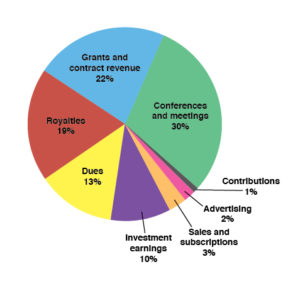
Members may not be aware that AAG dues are only 13 percent of our total income (see the accompanying graphic). We have a very progressive dues structure based on income, but this may disadvantage us in terms of retaining members as they transition from school to initial employment in the public sector or as an assistant professor or a post-doctoral position. This hypothesis is supported by the results of the membership survey conducted by the consultancy McKinley Associates. Building on this finding, vice-president Glen MacDonald asked graduate students in his group to reflect on membership issues and prepare a report. Their conclusion was that the cost of AAG student membership dues and meetings may be too prohibitive for full and consistent engagement with the organization.

When the Executive Committee met in mid-February, we discussed the membership survey and related issues. To what extent are annual student dues a revenue generator for AAG? Can recent graduates be eased gradually into a professional membership fee? Can AAG enhance its travel grants and work-study program to subsidize student participation in the annual meeting? Is this an opportunity to strengthen the intellectual value of regional meetings that are frequently more affordable?

We asked Doug Richardson and Meridian Place staff to carefully examine the dues structure and related issues; the Membership Committee under the leadership of Shawn Hutchinson (Great Plains-Rocky Mountains) is also examining policy changes. We will analyze the data and proposals in San Francisco with an eye toward retaining membership at the lower end of the dues structure while not bleeding those at the upper end. What do you think? And to learn more about the membership survey, please plan to attend the survey session on Friday, April 1, at 11:40 in Golden Gate 1, Hilton. All will be revealed, no joke!

Example 3: Graduate Education

At the fall meeting, Sara Diamond on behalf of graduate students, asked Council and the Association to endorse a series of best practices to guide departments in their relations with graduate students. This is a very interesting idea but Council felt the list of practices as presented needed deeper consideration; some of the requests are beyond the scope of any individual department to provide, for example, access to affordable housing. Sue Roberts, National Councillor, and I are working with Sara to redraft a document consisting of two parts, one for departments to use as guidance when they develop their own programs and one for students to use as they make the decision about where to attend graduate school. These documents should be extremely useful in ensuring that departments are healthy for students as well as faculty. What are your thoughts?

In each of these examples I hope I have highlighted some of the ways Council and staff work to improve our organization and discipline. To conclude, I’d like to refer you to the AAG Long-Range Plan. A copy of this document will be in each bag at the annual meeting. It is our touchstone as we move forward and I wish to highlight it here as another example of the work of once and future Council members.

DOI: 10.14433/2016.0006

    Share

Randall A. Detro

Randall Detro, former professor of geography at Nicholls State University and Director of the Placename Survey of Louisiana, passed away on March 7, 2016.

Randall Augustus Detro was born in 1931 and grew up in Red River Parish, Louisiana, a state to which he stayed devoted for his whole life.

Detro was primarily a cultural geographer but his work spanned many aspects of the human and physical landscape of Louisiana.

He had a particular interest in toponymy. His doctoral thesis, completed at Louisiana State University in 1970, was entitled “Generic Terms in the Place Names of Louisiana: An Index to the Cultural Landscape.” He published a number of other papers and book chapters on the toponymy of Louisiana, and also served as the Director of the Placename Survey of Louisiana. With Jesse Walker he compiled the work of Meredith (Pete) F. Burrill on geographic names in The Wonderful World of Geographic Names (Louisiana State University, 2004).

He contributed to a range of studies on human interactions with the natural environment of the Mississippi delta region, including settlement regression along the Louisiana coastal marsh, the coastal marsh as a recreational resource, the socioeconomic conditions of the deltaic region, the development of the marsh buggy as a means of transportation in difficult terrain, an environmental impact statement on deep draft access to Baton Rouge ports, the development of the sulphur industry and mines in Louisiana, and a historical atlas of shipwrecks in the Mississippi River.

Detro taught in the Department of Geography at Nicholls State University in Thibodaux, Louisiana, and also served as Director of the university’s library. He was a long time member of the American Association of Geographers and presented his distinctive Louisiana-focused research at many Annual Meetings of the AAG and the Southeast Division.

    Share

Point Reyes National Seashore: A Brief History of a Working Landscape

A working landscape of Point Reyes National Seashore.

Just a mere forty windy miles north of San Francisco is a popular natural wonder. Point Reyes National Seashore and the Phillip Burton Wilderness Area are prime destinations for visitors near and far. While many visit these places to fulfill their quest to get away from the hustle and bustle of the nearby city life and commune with the natural landscapes, some folks get to call the seashore home. Point Reyes National Seashore is a working landscape, containing dairies and ranches that have been in place for generations. However, with mixed use comes disagreement over the proper use of the space and discussions on the purpose of national park system units.

Long before Point Reyes became a National Seashore and a site for controversy, it was home to the Coast Miwok tribes. Living on the Point Reyes peninsula for centuries, the Coast Miwok found their lives uprooted when they were relocated to nearby Missions in the late 1700s to early 1800s (DeRooy and Livingston 2008). After the Coast Miwoks’ expulsion, Mexican rancheros grazed cattle on the land during the 1830s. When California became part of the United States in 1850, the land was divided by the owners into 32 tenant-run diaries and cattle ranches to keep up with the demand from the urban centers of the San Francisco Bay (Watt 2002; Deur and Mark 2011). World War II even brought mining and military installations to this future “untrammeled” wilderness area.A great deal of the current contention lies around the fundamental issue of working landscapes as park land. While it may be controversial, the presence of grazing on the land at Point Reyes National Seashore has provided a number of ecological benefits, such as a greater number and variety of native grasses as compared to areas that have suffered shrub invasion where grazing was removed (Rilla and Bush 2009). In recent years there have been a number of issues at Point Reyes that have escalated controversy and caused a fracturing between the tenants at Point Reyes National Seashore, the National Park Service, park visitors and environmental groups. Some of the recent issues causing tension include the removal of Drakes Bay Oyster Company from the park, ranchers being denied renewal of their leases at the seashore, Tule elk competing with ranchers’ cattle herds, and an outdated general management plan. However, despite the disputes over the landscape that have been building in the last few years, the parties all agree that Point Reyes is unique place worthy of protection.

After studying the area since the 1930s as a potential location for a public recreational area to serve the residents of the growing city of San Francisco, in 1962 in an attempt to stave off a potential housing development, the National Park Service decided to establish the Point Reyes National Seashore (PRNS) as a 53,000 acre recreational area, including a 21,000 acre pastoral zone, located on the Point Reyes Peninsula in Marin County, California. In 1976 an additional 25,370 acres were designated as the Phillip Burton Wilderness Area at Point Reyes National Seashore. Within the PRNS and wilderness area 8,003 acres were designated as potential wilderness additions. Today PRNS is a 71,028 acre park preserve. As previously mentioned, Point Reyes has continued to be an area of mixed use between commercial and recreational activities, allowing for some agricultural uses to continue on the protected lands.[1] As noted by Deur and Mark, “The continued operations of dairies and ranches became an integral part of the park, and the NPS found itself having to work with ranchers directly as neighbor and often owner. When the NPS carried out purchases of ranch land, it usually granted reservations of use and occupancy for a period of 25 years to those who wished to continue ranching” (Deur and Mark 2011). Although these uses were allowed to remain, they were not without restrictions and remained exceptions, giving less power and control those who worked the land.

Map displaying the location of Point Reyes National Seashore (Point Reyes Getaways, 2015).

In a report on resident communities in national parks, Douglas Deur, University of Washington researcher, and Stephen R. Mark, NPS Historian, note the balancing act that the NPS has been conducting over the years between the expectations of a pristine landscape by park visitors and the need to respect the communities that reside in and help shape the parkland. In reviewing four case studies for the management of agriculture in national parks, Deur and Mark point to Point Reyes National Seashore as an “outstanding example” of a thriving mixture of agriculture and parkland. However, the authors state, “…as landlord at Point Reyes, the NPS continues to be challenged by the complexities inherent with maintaining economically viable ranch operations within a recreation area where visitors see natural values as predominant. Many of the ranchers have nevertheless viewed the NPS presence as beneficial, since the peninsula also represents the only large block of land in Marin County remaining in agricultural production”(Deur and Mark 2011). Deur and Mark conclude with describing Point Reyes as an experiment of sorts between a combination of private and public uses in order to please the multiple stakeholders.The 1964 Wilderness Act, that was used to establish the Phillip Burton Wilderness Area at Point Reyes National Seashore in 1976, envisioned wilderness as an, “…area where the earth and its community of life are untrammeled by man, where man himself is a visitor who does not remain…without permanent improvements or human habitation, which is protected and managed so as to preserve its natural conditions…” (Public Law 88-577). While this was the vision of wilderness seen through the eyes of Wilderness Society’s Howard Zahniser, the author of the Act, the Act also contained many exceptions, such as non-conforming prior uses. Point Reyes never quite fit the ideal model of a wilderness area, as it was the first area to receive the designation of potential wilderness lands. While the NPS may have a history of accepting alternative uses within the park land at Point Reyes, it appears with recent tensions and decisions that they are headed down the traditional path of park management, one that excludes people, other than tourists, from their vision.

Environmental historian, Laura A. Watt, has been researching the case of Point Reyes National Seashore for over a decade. She has written a number of articles on Point Reyes and has a forthcoming book on the subject, The Paradox of Preservation: Wilderness and Working Landscapes at Point Reyes National Seashore. Watt’s work explores the controversy over Drakes Bay Oyster Company[2] through the lens of preservation and the ideas that surround what a park ‘ought’ to be. In order to understand the progression of issues at Point Reyes, Watt reviews the ideology that underpins the historical development of the National Park Service and the United States’ ideals of park land and the effect these ideals have had on the establishment and management of PRNS.

Point Reyes is a particularly distinctive unit in the U.S national park system, comprised of both a wilderness area and working landscapes as park land. While the disputes over the space have been increasing recently, much of the root of the tension lies in the designation of the space. The National Park Service has the challenging mission of both protecting the space while also providing for the enjoyment of the visitors and overseeing the commercial uses of the protected land. They have often chosen in the past to view society as separate from nature, fostering the perception that the two are incompatible, and thus dictating who is allowed access to a particular resource.   In her article, “The Trouble with Preservation, or, Getting Back to the Wrong Term for Wilderness Protection: A Case Study at Point Reyes National Seashore”, Laura Watt provides several propositions to help counteract the myth of wilderness as separate from that of human use. She proposes the use of a continuum of standards for wilderness determined by the degree to which the area has been inhabited and people have manipulated the land, rather than an all or nothing approach, a sentiment shared by William Cronon (Cronon 1996). Watt also suggests that, “the NPS and other land management agencies could help to heal this disconnect between nature and culture by encouraging the public to understand the human history of natural areas, even while continuing to manage wilderness values”(Watt 2002). Nevertheless, the decisions of who is allowed access, and of what type, in a conserved space can have profound impacts not only on the visitors to the space, but on the residents that depended on that space for their livelihoods.


References

Cronon, William. 1996. “The Trouble with Wilderness; Or, Getting Back to the Wrong Nature.” In Uncommon Ground: Rethinking the Human Place in Nature, edited by William Cronon, 69–90. New York/London: W.W. Norton and Company.

DeRooy, Carola, and Dewey Livingston. 2008. Point Reyes Peninsula: Olema, Point Reyes Station, and Iverness. San Francisco: Arcadia Publishing.

Deur, Douglas, and Stephen R Mark. 2011. Resident Communities and Agriculture in National Parks : An Assessment and Prospectus.

Rilla, Ellie, and Lisa Bush. 2009. The Changing Role of Agriculture in Point Reyes National Seashore. Novato. https://ucanr.org/sites/uccemarin/files/31000.pdf.

Watt, Laura A. 2002. “The Trouble with Preservation, Or, Getting Back to the Wrong Term for Wilderness Protection: A Case Study at Point Reyes National Seashore.” APCG Yearbook 64: 55–77.

Notes

[1]. For further detail on the acts establishing PRNS and the Wilderness area, see Laura A.Watt’s
forthcoming book, The Paradox of Preservation: Wilderness and Working Landscapes at Point Reyes National Seashore.

[2]. The Drakes Bay Oyster Company controversy involves the issue of whether or not the Department of the Interior would reinstate the company’s lease to commercially harvest oysters at PRNS. The decision was made to expel Drakes Bay Oyster Company from the park in December 2014. While outside the scope of this paper, this is a fascinating case that can be explored further in Laura A. Watt’s forthcoming book, The Paradox of Preservation: Wilderness and Working Landscapes at Point Reyes National Seashore.

    Share

Liza Giebel Joins AAG Staff as IT Support Specialist

The American Association of Geographers is pleased to announce that Liza G. Giebel has joined the staff as an IT Support Specialist at its headquarters in Washington, D.C.

Prior to coming to work for AAG, Liza worked for the Amalgamated Transit International Union for seven years where she was responsible for solving a myriad of IT issues and managing the internal network and databases.

Her background includes studies at the Borough of Manhattan Community College and adventures growing up in Brooklyn, N.Y. She is also a volunteer at the National Multiple Sclerosis Society in D.C.

When she’s not working with AAG staff to make sure technology is running smoothly, she enjoys working in her hop and vegetable garden, salsa dancing and taking in the museums and sites of the nation’s capital.

    Share

New NSF REU Experience for Undergraduates: Community GIS and Citizen Science in Belize

This summer at the University of Central Florida, we are pleased to host the first year of our National Science Foundation Research Experiences for Undergraduates (REU) Site “Preparing the Next Generation of Scholars through Community GIS and Citizen Science.” Our program offers fully funded summer research experiences for at least 8 undergraduate students in Belize for 5 weeks and Orlando for two weeks. The program is open to all U.S. students and runs June 20-August 5, 2016. We are interdisciplinary in nature emphasizing community geography, community GIS, and citizen science through mixed methods, including sketch mapping, mobile mapping applications, focus groups, in-depth interviews, GIS, and spatial analysis. Please distribute to interested students and your networks.

Research opportunities: Students will work in one of two research directions with community partners and mentors from University of Central Florida, University of Belize, Georgia State University, and The Smithsonian National Museum of Natural History’s Caribbean Coral Reef Ecosystems Program:

  • Research Direction 1: Mapping disparities in flooding & disaster management
  • Research Direction 2: Mapping marine debris & mitigating impacts on coastal communities

Compensation: Each REU student will receive a competitive funding package, including a $3500 research stipend, $1400 meal allowance, free shared housing in Belize and Orlando, up to $750 in travel support to/from the REU Site, up to $750 for post-REU conference travel, and 2 research methods books.

Application process: The priority application deadline is Friday, March 25th @ 5 PM EST. Complete program information and application instructions can be found at https://www.citizensciencegis.org/ucf-reu-site/.

Student reflections from the field: “Challenging, emotional, fun, collaborative, thought-provoking, interesting, real-life, and eye-opening.” These are some of the words used by students to describe our previous research programs. We expect similar experiences in our new REU! Check out a series of short videos from our students at:https://www.citizensciencegis.org/ucf-reu-site/student-reflections/.

Questions can be directed to:

  • Dr. Timothy Hawthorne: Principal Investigator, Assistant Professor of Geographic Information Systems at University of Central Florida
  • Dr. Christy Visaggi: Co-Principal Investigator, Lecturer of Geosciences at Georgia State University

Check us out on the web and share on social media!

    Share

New Books: February 2016

Every month the AAG compiles a list of newly-published books in geography and related areas. Some are selected for review in the AAG Review of Books.

Publishers are welcome to send new volumes to the Editor-in-Chief (Kent Mathewson, Editor-in-Chief, AAG Review of BooksDepartment of Geography and Anthropology, Louisiana State University, Baton Rouge, LA 70803).

Anyone interested in reviewing these or other titles should also contact the Editor-in-Chief.

February, 2016

    Share

A New Rx for the Food Movement in San Francisco

With large-scale demand and a mission to protect public health, hospitals are emerging as the next frontier of the sustainable food movement. Health care institutions spend $12 billion in the food and beverage sector each year,1 and a single hospital can have an annual food budget of $1–7 million or more.2 Even small shifts in foodservice budgets can create new markets for alternative foods.

To date, the darlings of the food movement have been farmers’ markets, Community Supported Agriculture (CSA) programs, and urban farms that connect eaters directly with the source of their food. These models appear to have boosted the number of small farmers in the U.S. after decades of freefall,3 but research shows that we now have an increasingly bifurcated system that favors small-scale direct markets and large-scale commodity markets. What’s more, experts believe that direct market models are reaching a saturation point even though they’ve barely begun to scratch the surface of the agricultural status quo. Local food sales account for less than two percent of total farm gross, and the goods exchanging hands at some 7,800 farmers’ markets nationwide represent less than one percent of total U.S. agricultural production.4

Meanwhile, mid-sized family farmers are being squeezed out by the march of consolidation within the food system, as are independent middlemen that aggregate, process, and distribute food regionally.5 This agriculture of the middle, meaning mid-sized family farmers and mid-level food system intermediaries, represents the most threatened set of entities in the agricultural sector. Direct market models hold little sway in solving this problem, they are too small to support mid-sized farmers, and they purposefully cut out middlemen.

Leading-edge food system advocates are looking to institutional buyers like hospitals, schools, and universities to help rebuild this missing middle ground because they buy in large volumes and they rely on the wholesalers, processors, and distributors that make up the functional infrastructure of the U.S. food system. But the leap in scale from an individual buying three onions at a farmers’ market to a hospital buying three hundred cases is not simply one of numbers, it presents an entirely different set of challenges, opportunities, and relationships. When you’re making soup for six hundred, changing your grocery list quickly gets complicated.

A team of San Francisco Bay Area hospitals have been at the vanguard of this institutional food revolution since 2005. Leaders including Kaiser Permanente, University of California at San Francisco Medical Center, John Muir Health, and the San Francisco VA Medical Center, gathered at the FoodMed Conference in Oakland, California that year. A non-profit organization called Health Care Without Harm convened leaders from the sustainable agriculture, environmental health, public health, and health care sectors to discuss their overlapping concerns and goals. Together, they articulated a systemic environmental nutrition approach to healthy food, going beyond counting calories and balancing food groups to address the many ways the food system impacts public health.

Since then, over 550 hospitals nationwide, they have signed a Healthy Food in Health Care Pledge generated by the nonprofit coalition Health Care Without Harm (HCWH) which states that “for the consumers who eat it, the workers who produce it and the ecosystems that sustain us, healthy food must be defined not only by nutritional quality, but equally by a food system that is economically viable, environmentally sustainable, and supportive of human dignity and justice.”

Hospitals are putting this vision into practice by serving local produce when it’s in season, switching to rBGH-free dairy products, and sourcing seafood from community-based fisheries. They are buying fair trade coffee, cage-free eggs, and organic salad greens. Some are reducing meat servings to lower their greenhouse gas footprint and are using the cost savings to buy grass-fed beef and free-range chicken raised without antibiotics or added hormones.

“Local, organic chicken was a real challenge” says one leading Bay Area Hospital Food and Nutrition Services Director.   Under the current system, he can place an order on his food distributor’s website, and the next day hundreds of uniform 4-ounce chicken breasts show up on his loading dock, shrink-wrapped and stacked by the case. Procuring local, organic chicken first required weeks of working through bureaucratic purchasing and legal systems to set up a new vendor relationship. When the hospital finally received its first delivery, it was an ice-packed box of whole chickens with the heads and feet still on.   “My cooks almost died,” he reports. Having to chop off chicken heads is a far cry from lining up a row of boneless, skinless meat parts in the griller. Most institutional kitchens no longer have the equipment or staff with the knowledge necessary to deal with whole foods.

The pallets of uniform poultry parts that come through national distributors like Sysco and US Foods also help hospitals to meet strict federal dietary guidelines, as each cut arrives within a fraction of the weight ordered. In contrast, locally-sourced chicken breasts, even if they arrive pre-processed, might come in a four to eight ounce range, forcing staff to slice and individually weigh servings. With tight budgets, paying staff to mete out perfect portions may not be time that a hospital foodservice department can afford.

Efficiency has been a dirty word in some food movement circles, but a little efficiency goes a long way when you’re serving hundreds to thousands of meals every day. Equally blasphemous has been middlemen. But buying food at the institutional scale means relying on certain industrial-style standards and relationships. Hospitals are a microcosm of the challenges that face the alternative food movement as it seeks to scale up — they need to balance their sustainable food goals with their need for efficiency and affordability.

Initiatives like the Farm Fresh Healthcare Project offer insight into how leading hospitals are working with distributors to retrofit existing supply chains to become shorter, more flexible, and more transparent. Since 2011, a team of hospitals in the San Francisco Bay Area have partnered with Health Care Without Harm and Community Alliance with Family Farmers to source more local and organic produce from family farmers.

Beyond purchasing power, hospitals can leverage another form of currency in support of organic agriculture – moral authority. Polls consistently show that health professionals rank as some of the most trusted experts in the United States. [1] They can “tell stories about great farmers,” as Luis Vargas, Procurement Manager for Nutrition and Food Services at University of San Francisco Medical Center says, “People look to us for this leadership, and we should be showing the way.” Like the first hospitals to ban smoking on their grounds, which led to greater public awareness and smoking restrictions in other locations,6 those that are leading the environmental nutrition movement are enacting changes that will have ripple effects throughout society.

—Kendra Klein

DOI: 10.14433/2016.0004


Citations

  1. Harvie. in Designing the 21st Century Hospital Vol. September   (Hackensack, NJ, 2006).
  2. FSD. 2011 Hospital Census, <https://www.foodservicedirector.com/sites/default/files/FSD%20Hospital%20Census%202011.pdf> (2011).
  3. Kirschenmann, F., Stevenson, S., Buttel, F., Lyson, T. & Duffy, M. Why worry about agriculture of the middle? , (MIT Press, 2008). DOI: 10.7551/mitpress/9780262122993.001.0001
  4. Barham, J. et al.   (ed USDA) (Agricultural Marketing Service, 2012).
  5. Lyson, T. A., Stevenson, G. W. & Welsh, R. Food and the mid-level farm: Renewing an agriculture of the middle. (The MIT Press, 2008).
  6. Cohen, L. & Mikkelson, L.     (Prevention Institute, Oakland, CA, 2004).


[1] Gallup 2014. Honesty/Ethics in Professions 2013. Available online: https://www.gallup.com/poll/1654/honesty-ethics-professions.aspx.

    Share

David J. De Laubenfels

David de Laubenfels, emeritus professor in the Department of Geography at Syracuse University, and a biogeographer who was an expert on tropical conifers, passed away on February 6, 2016, at the age of 90.

David John de Laubenfels was born   in 1925 in Pasadena, California. His father, Max Walker de Laubenfels, was a noted marine biologist which perhaps influenced the development of David’s interests in the natural world.

After serving in the Quartermaster Corps of the United States Army during the Second World War, de Laubenfels attended Colgate University, NY. As part of his undergraduate studies, he completed “A Geographic Study in the Hamilton Area, New York.” Having graduated in 1949 he moved to the University of Illinois for postgraduate studies. His master’s degree, completed in 1950, included a thesis entitled “Marketing Geography of Open Display Cold Storage Equipment” while his doctorate dissertation, completed in 1953, was entitled “The Temuco Region, A Geographic Study in South Central Chile.” Despite the subject matter of these three studies, he was already gravitating towards physical geography and, more particularly, to biogeography.

His first professional appointment was at the University of Georgia, starting as Assistant Professor in 1953 and moving to Associate Professor in 1958. In 1959 he joined the faculty at Syracuse University where he remained for the rest of his career, attaining the rank of full Professor in 1971 and retiring as Professor Emeritus in 1993.

De Laubenfels studied the variation of vegetation from place to place. Among his many publications in biogeography are the books A Geography of Plants and Animals (1970) and Mapping the World’s Vegetation: Regionalization of Formations and Flora (1975).

He carried out various studies in the United States, publishing articles on the soil and vegetation of New York State, the characteristics of the Ozark Upland in the Midwest, the nature and boundaries of the Corn Belt, conifers of southeast, and the semi-tropical woodland of Georgia. He also did a comparative study of Australian forests with vegetation of similar climatic areas in the Americas.

However, it is for his work on the taxonomy of conifers, particularly tropical conifers, that de Laubenfels is known throughout the world. In carrying out his studies, he traveled whenever possible to the actual locations where the plants were established so that he could see them in their many natural growth forms. He had a particular interest in the south Pacific, carrying out field expeditions to locations including New Caledonia, Fiji, Papua New Guinea and the Moluccas. New Caledonia was of particular interest due to the rare conifers there; on one of his expeditions he discovered a parasitic conifer and published his finds in Science (1959). He also studied conifers in Latin America including Costa Rica, Venezuela, Peru and Uruguay.

His first major taxonomic revision in conifers was published in 1969: “A Revision of the Malesian and Pacific Rainforest Conifers, I Podocarpaceae.” In 1972, his chapter on “Gymnospermes” published in Flore de la Nouvelle-Caledonie et Dependances was a seminal piece of work because of the importance and uniqueness of this group of plants. Another major taxonomic publication, Coniferales, Flora Malesiana was published in 1988. Over the years, de Laubenfels identified over 100 new species in the tropics; in the photograph above he is examining Podocarpus beecherae, one of those he named. He also had one species named in his honor – Araucaria laubenfelsii, commonly known as the De Laubenfels’ araucaria – which is native to southern New Caledonia.

Outside of his taxonomic and plant geography work, de Laubenfels had a wide variety of interests on topics such as the geographic origins of human development and the origins of language. He also published a book on physics entitled It’s Hard to Believe in Infinity (1992). Meanwhile in another work, “Where Sherman Passed By” (1957), he highlighted General Sherman’s march through Georgia, walking the entire route using the maps of his great-grandfather, John (Rziha) Laube de Laubenfels, chief topographical engineer for one of Sherman’s columns.

De Laubenfels joined the American Association of Geographers in 1949 and was involved in the Regional Division that included New York State, presenting papers at regional meetings including “Plant Geography Versus Vegetation Geography” (1962) and “The Variations of Vegetation from Place to Place” (1968).

He was also a member of the American Conifer Society and British Conifer Society. His love of nature was reflected locally too: he was a long-time member of the Onondaga chapter of the Adirondack Mountain Club.

David de Laubenfels will be remembered for his major contributions to biogeography and his unparalleled expertise in tropic conifers. He had a remarkable career, with academic publications spanning from 1950 to 2015 when he was in his 90th year.

He is survived by his loving wife, Janet, three daughters, five step-children, several grandchildren and two great-grandchildren, as well as three siblings. He was predeceased by his son, Eric.

    Share

Harold M. Rose

Harold Rose, distinguished professor emeritus of geography and urban studies at the University of Wisconsin-Milwaukee, and pioneer in research on race and segregation, passed away on February 2, 2016, at the age of 86.

Harold Milton Rose was born on January 8, 1930 in Nashville, Tennessee. He was raised by his grandparents, of whom his grandfather worked in a phosphate mine and his grandmother as a domestic.

Despite skipping several grades in school, he went to college at the age of 16 – somewhat by chance – having had heard that a friend had applied to Tennessee State, a historically black college, and been accepted. Rose paid his way through his four years of college by working in the cafeteria every day.

Having graduated with a degree in history and geography in 1950, Rose spent time in the Army then returned to Tennessee State to take some further geography courses. There he was encouraged by a professor to apply for a master’s program at Ohio State University.

He taught for a few years at Florida A&M University in Tallahassee, also a historically black college, before returning to Ohio State University for a doctorate in geography. His thesis, completed in 1960, was entitled “An Analysis of Land Use in Central-North Florida: A Study in Conservation.”

In 1962, Rose received a joint appointment in the departments of geography and urban affairs at the University of Wisconsin-Milwaukee (UWM), one of the first tenured African American professors at the university. Although he was sought by other universities, Rose spent his entire career at UWM. This included serving as chair of the Department of Urban Affairs (1970-1973 and 1974-1977), Department of Afro-American Studies (1977-1978), and Department of Geography (1990-1994).

Although Rose began his academic career exploring issues of natural resource management, he shifted focus after arriving in Milwaukee in 1962. He had moved to a deeply segregated city during a time of heightened civil rights activism around housing and school segregation. He pioneered research on the conditions faced by African Americans and went on to build a national reputation in the field, specifically how racism and racial policy affected urbanization.

Rose’s foundational work on racial discrimination and segregation challenged urban geographers to consider the ghetto as produced through both spatial and social processes. His scholarship established that examining segregation was not just about mapping the distribution of racial groups across the urban landscape, but also about understanding the social processes and attitudes about race that produced those patterns.

He conducted community-engaged research field research on the quality of life in black communities, the black ghetto, black residential mobility and interregional migration, high rates of homicide in many black communities, and the experience of blacks and Cubans in Miami.

Among his many publications on race, segregation and violence were the books “The Black ghetto: a spatial behavioral perspective” (1971), “Black Suburbanization: Access to Improved Quality of Life or Maintenance of the Status Quo?” (1976), and “Race, Place and Risk: Black Homicide in Urban America” (1990, coauthored with Paula McClain).

His academic research was driven by his passion for social justice. Aside from his scholarship, he was extensively involved in community service, from his early work with the Milwaukee Urban League to his seat on the Board of Directors for the community-based North Milwaukee State Bank.

Rose retired from UWM in 1995 as distinguished professor emeritus, after thirty-one years of teaching, pioneering scholarship, and a remarkable career of mentoring and public scholarship. The university established the Harold M. Rose Lecture series focused on race and urban social justice in tribute to his legacy to the department, the university and the discipline of geography.

Rose joined the American Association of Geographers in 1955. In 1976 he was elected its President, the first – and to date only – African American to hold that position. He used his platform to challenge urban racial segregation and discrimination. His presidential address entitled “Geographies of Despair” (subsequently published in the Annals of the AAG in 1978) voiced the need to expand research into the experiences of African Americans.

In 1996 Rose was awarded the AAG’s Lifetime Achievement Honor and in 2012 an award was created in his name – the Harold M. Rose Award for Anti-Racist and Practice in Geography – to honor geographers who have advanced the discipline through their research on racism, and who have also had on impact on anti-racist practice. To date the award has been given to Donald Deskins, Jr. (2013), Ruth Wilson Gilmore (2014), and Bobby Wilson (2015).

With the passing of Harold Rose, geography has lost an extraordinarily important figure. His research made significant contributions to geographic understandings of segregation and racism as a socio-spatial process. His work was courageous in challenging racism at a time when very few in geography even acknowledged racism and its consequences. He was also an exemplar of how scholars can go beyond theoretical understandings of social practices to engage actual communities and to make a difference in human life. Rose regretted that his life required him to be consumed with issues of race, but he knew that to be less involved was ‘simply not possible.’

Harold Rose was humble, kind and generous. He will be fondly remembered by many former colleagues and students at UWM and across the United States. He is survived by his lovingly wife of 60 years, Ann Louise, their son, Gregory, a granddaughter and three great-grandchildren.

    Share

AAG Archivist Geoffrey Martin Provides Rare Glimpses into the History of Geography

A near-capacity crowd gathered on January 21, 2016, in the Geography and Map Division at the Library of Congress in Washington, D.C., to hear a talk by the doyen of the history of geography, Dr. Geoffrey J. Martin, Professor Emeritus at Southern Connecticut State University and the official archivist of the American Association of Geographers (AAG) for more than 30 years.

Martin was invited to speak about his new book, American Geography and Geographers: Toward Geographical Science, which was published in 2015 by Oxford University Press. However, his talk was as much an account of his own career-long journey to collect material and write about the history of American geography as about the book itself.

As a young academic, Martin was drawn to three figures in American geography, who had shaped the discipline in the first half of the twentieth century: Mark Jefferson, Ellsworth Huntington and Isaiah Bowman. All studied at Harvard under William Morris Davis, the man who played a founding role in the establishment of the academic discipline in America. While Davis’s work focused on ‘physiograhy,’ his three disciples pursued new directions in geography which examined the physical earth as the home of man: Jefferson with anthropography; Huntington with physical climatology; and Bowman with the concept of region.

Over the years, Martin systematically collected archival information on the life and work of these three geographers which was published respectively as Mark Jefferson: Geographer (1968), Ellsworth Huntington: His life and thought (1973), and The life and thought of Isaiah Bowman (1980).

Following the publication of this trilogy, Martin then set out on a grander project: to tell the larger story of American geography and geographers. The recently published title covering the period from 1870 to 1970 took 17 years to research and write. It is a testament to Martin’s meticulous attention to detail — pursuing every lead, uncovering every possible manuscript, and tracking down every living person to interview.

Martin is an archivist extraordinaire. In the course of more than five decades of research, he visited 17 countries, consulted 300 archival holdings, accumulated 115,000 manuscripts, and personally corresponded with more than 100 people.

What came across during his presentation was Martin’s sense of sheer pleasure and privilege at being able to work with the living relatives of the key scholars in the book, including weekly lunches with Ellsworth Huntington’s wife and four successive summers spent in the basement of Isaiah Bowman’s son, Bob. He also told stories about some of the challenges and frustrations of working with archival material, from a will that prevented access for 50 years (which he negotiated with the family down to 25 years) to a son who ceremonially burned manuscripts from his father’s archive from time to time. During the Cold War, he also had to defend himself during the McCarthy investigations after a colleague turned him in for allegedly being a Communist sympathizer. The unjustified evidence was a small set of Russian books on chess strategies from when he was a world-class champion of the game.

Martin, now in his early 80s, is truly of the old school. He has not embraced modern technology, which makes one respect his research and writing even more — from his correspondence carried out by hand-written letter to his dedication in answering geography questions via telephone at any time of day or night.

Martin’s expansive and in-depth knowledge of the history of geography and geographers is unparalleled. Through his exposition of the main characters in American geography, one feels to have actually met them personally. The joy of listening to Geoffrey Martin is the combination of hearing an authoritative scholar, as well as an entertaining raconteur.

Sadly, these days the history of geography is not a particularly popular sub-discipline, but geographers of all ages and all nations ought to pay heed to Geoffrey Martin’s landmark text, American Geography and Geographers.

Ralph Ehrenberg, Chief of the Geography and Map Division at the Library of Congress, and Douglas Richardson, Executive Director of the AAG, took the opportunity to not only honor Martin at Thursday’s event, but also to introduce the recent agreement of the consolidation of the AAG’s century-plus old archives to the Library of Congress. Collections are currently being moved from several scattered locations to this central place, which will make many important and rare materials available to scholars and historians worldwide. In celebration of this, and to complement Martin’s talk, the Geography and Map Division displayed unique and rare historic maps, documents and other artifacts.

    Share