GIS Career Mentorship with High School Juniors in Virginia
 GeoMentor Volunteers: Clark Nexun Firm (Pravin Mathur, Kate Chaney, Jose Carvalho, Janet Webster, Gene Corbell)
Location: Chesapeak, Virginia
Grade level of participating students: 11th
Activity Theme/Focus: GIS Immersion
Number of Participants: 9
How did you connect with your collaborator? The initial partnership was introduced through an employee whose son attended the school. We have continued to partner with the school each summer.
Describe your collaboration process. There is an initial information night for the students where they can meet with representatives from different firms/companies. The students are then allowed to sign up for the company they are interested in. A colleague met with the Department Heads to see how much time they can commit to mentoring the students each summer. Then they let the teacher/school know how many students we can accept each summer.
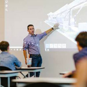
Describe your tasks/involvement. Clark Nexsen is a multi-disciplinary firm — Architecture, Civil Engineering, GIS, Transportation, Bridges, Wireless and Interiors. Each summer, high school students enrolled in the STEM program are invited to our corporate office for a week of immersion. The STEM students meet for several hours with each department, to learn about how professionals in these fields do their day-to-day projects.
The GIS Department and the Wireless Department had the students for a two-hour span. We divided our GIS information into four sections:
- Basic Overview: What is GIS?, How many industries GIS supports, How GIS can be used to analyze data to solve problems, and How we use GIS at Clark Nexsen. Also, the components of GIS, a BASIC explanation of Map Projections, and images of GPS equipment. We then provide them with links to local colleges with Geospatial classes and programs with links to useful geospatial websites.
- Introduction Videos: This year we added videos from the ESRI Users Conference.
- GIS related Apps that are fun to use: We showed how we use the what3words free app during our demonstration — mostly for fun and adventure/social activities in our off hours, but also to assist us in foreign countries where there is a language barrier. We also demonstrated ESRI StoryMaps and viewed a few public StoryMaps created by other users.
- Field Data Collection & Equipment Overview: A demonstration of some of our equipment we use in the field was presented — Leica Disto Laser Range finders for measuring building footprints (we let the students measure the room), the Trimble GPS units (more about this later) and the Tough Pads with Draft Site (a lite CAD program) and ArcGIS Desktop loaded. We were partnered with our Wireless Department and they demonstrated the Leica 360 Scanner and discussed the benefits of use and how the technology works.
We conveyed what makes the GPS equipment work, but also shared an example of how the equipment could be used to benefit our clients. Some examples covered were on the benefits of data produced by feature collection efforts and the sort of information one could assign to those points collected (attribution).
Our overarching goals were to engage the students, open their awareness to GIS, and show how they are already interacting with GIS without even realizing it (navigational apps). Most of the students were focusing on Engineering studies. We showed them GIS and the science behind engineering and other market sectors. We explained how we solve complex questions through the analyzing of spatial data. Once in college, Clark Nexsen offers them to return to us for their internships during the summer months. Once graduated from college, some of our interns have returned to start their careers with us.
What did you gain from the experience? What do you think your educator collaborator and/or the students gained? Our GIS department gained a new perspective of how little the high school demographic is aware of GIS as a stand-alone technology field of study, how the Science of Where is at the forefront of so many industries, and how GIS plays a role in their daily lives.
We are hoping they gained a general understanding of GIS and how it can walk lock-step with the STEM industries they are interested in pursuing. We provided follow-up information on the colleges offering GIS programs and a sheet of helpful weblinks to Geospatial websites.