GIS Day with 5th Graders in Delaware

Photo of Nicole MinniGeoMentor Volunteer: Nicole Minni

Location: Delaware (statewide)

Grade level of participating students: 5th

Activity Theme/Focus: Geography, Social Studies

Number of Participants: 490

How did you connect with your collaborator?  In Delaware we have a GIS Day Committee. Through this committee we hold a field trip every year for 5th grade classes. This field trip takes place at the Air Command Mobility Museum in Dover. We are in our 8th year holding this event. Our field trip we can only hold 240 students, so this year we are taking parts of the field trip on the road to two other schools, allowing us to connect for even more students than ever. 

Describe your collaboration process. We communicate with all the teachers by email and through post office mail. We create name tags for all the students and place them in groups. We place the students from each school in groups, which consists of approximately 15 students each. Volunteers (GIS mentors) throughout the state assist with setting up the GIS related stations, which each of the student groups travel to. The students are at each station for approximately 30 minutes and they see about 17 stations. We make sure to accommodate any special needs that the children might have as well.

Describe your tasks/involvement. Each of the stations vary, so the students are exposed and involved in many careers all relating in some way to GIS. We have the Kent County Mobile Command unit come and show how they use GIS in 911 situations. The kids also get to learn about Delaware Soils from NRCS and walk away with their very own soil sample. Another station is a hands-on GIS lab which the students take an hour to do an ArcGIS Online exercise. They also learn how to fly on a flight simulator and then they get into a 20′ Earth balloon from the Delaware Children’s museum to learn about the Earth. We also have the students learn about aerial photography by having them trace different features on the map using transparencies and they get to take them home as well.

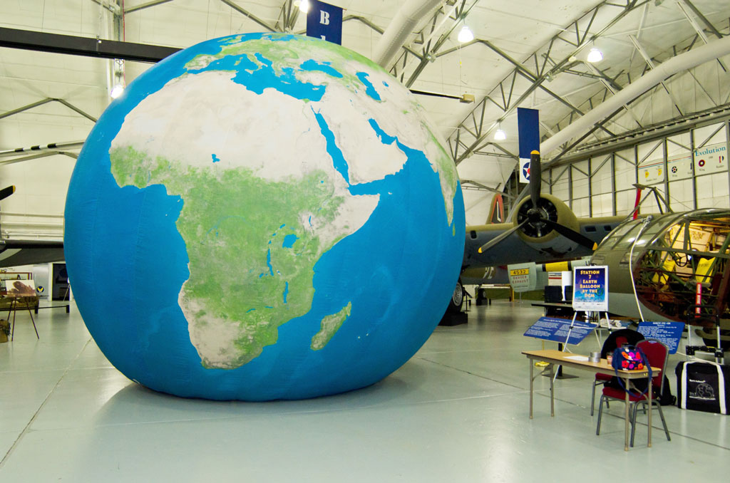
In November of 2015 on GIS Day, Nicole Minni took a class on a field trip to the Delaware Children's museum to learn about the Earth by walking into this 20-foot inflatable Earth balloon.
Nicole Minni took a class on a field trip to the Delaware Children’s museum to learn about the Earth by walking into this 20-foot inflatable Earth balloon.


What did you gain from the experience? What do you think your educator collaborator and/or the students gained?  The GIS Day Committee consists of seven people. We also have approximately 18 volunteers and 17 station chiefs for the day of the event. We all gain so much knowledge from hosting this event. We learn from the kids and what questions they ask and what their experience is. We also learn from the educators how they experienced the event. We provide a survey each year, so we can continue to improve and make it the most memorable experience. The kids are exposed to approximately 15 different careers in GIS, which is exciting.

Additional comments: We all love being a GeoMentor!

    Share

Outdoor Learning and GIS Day Activities with K-5th Grade in Arizona

Photo of Nicole MinniGeoMentor Volunteer: Nicole Minni

Location: Delaware (statewide)

Grade level of participating students: 5th

Activity Theme/Focus: Geography, Social Studies

Number of Participants: 490

How did you connect with your collaborator?  In Delaware we have a GIS Day Committee. Through this committee we hold a field trip every year for 5th grade classes. This field trip takes place at the Air Command Mobility Museum in Dover. We are in our 8th year holding this event. Our field trip we can only hold 240 students, so this year we are taking parts of the field trip on the road to two other schools, allowing us to connect for even more students than ever. 

Describe your collaboration process. We communicate with all the teachers by email and through post office mail. We create name tags for all the students and place them in groups. We place the students from each school in groups, which consists of approximately 15 students each. Volunteers (GIS mentors) throughout the state assist with setting up the GIS related stations, which each of the student groups travel to. The students are at each station for approximately 30 minutes and they see about 17 stations. We make sure to accommodate any special needs that the children might have as well.

Describe your tasks/involvement. Each of the stations vary, so the students are exposed and involved in many careers all relating in some way to GIS. We have the Kent County Mobile Command unit come and show how they use GIS in 911 situations. The kids also get to learn about Delaware Soils from NRCS and walk away with their very own soil sample. Another station is a hands-on GIS lab which the students take an hour to do an ArcGIS Online exercise. They also learn how to fly on a flight simulator and then they get into a 20′ Earth balloon from the Delaware Children’s museum to learn about the Earth. We also have the students learn about aerial photography by having them trace different features on the map using transparencies and they get to take them home as well.

In November of 2015 on GIS Day, Nicole Minni took a class on a field trip to the Delaware Children's museum to learn about the Earth by walking into this 20-foot inflatable Earth balloon.
Nicole Minni took a class on a field trip to the Delaware Children’s museum to learn about the Earth by walking into this 20-foot inflatable Earth balloon.


What did you gain from the experience? What do you think your educator collaborator and/or the students gained?  The GIS Day Committee consists of seven people. We also have approximately 18 volunteers and 17 station chiefs for the day of the event. We all gain so much knowledge from hosting this event. We learn from the kids and what questions they ask and what their experience is. We also learn from the educators how they experienced the event. We provide a survey each year, so we can continue to improve and make it the most memorable experience. The kids are exposed to approximately 15 different careers in GIS, which is exciting.

Additional comments: We all love being a GeoMentor!

    Share

Online Mapping with 4th-5th Graders / GIS and Public Health with 9th Graders in Georgia

Photo of Nicole MinniGeoMentor Volunteer: Nicole Minni

Location: Delaware (statewide)

Grade level of participating students: 5th

Activity Theme/Focus: Geography, Social Studies

Number of Participants: 490

How did you connect with your collaborator?  In Delaware we have a GIS Day Committee. Through this committee we hold a field trip every year for 5th grade classes. This field trip takes place at the Air Command Mobility Museum in Dover. We are in our 8th year holding this event. Our field trip we can only hold 240 students, so this year we are taking parts of the field trip on the road to two other schools, allowing us to connect for even more students than ever. 

Describe your collaboration process. We communicate with all the teachers by email and through post office mail. We create name tags for all the students and place them in groups. We place the students from each school in groups, which consists of approximately 15 students each. Volunteers (GIS mentors) throughout the state assist with setting up the GIS related stations, which each of the student groups travel to. The students are at each station for approximately 30 minutes and they see about 17 stations. We make sure to accommodate any special needs that the children might have as well.

Describe your tasks/involvement. Each of the stations vary, so the students are exposed and involved in many careers all relating in some way to GIS. We have the Kent County Mobile Command unit come and show how they use GIS in 911 situations. The kids also get to learn about Delaware Soils from NRCS and walk away with their very own soil sample. Another station is a hands-on GIS lab which the students take an hour to do an ArcGIS Online exercise. They also learn how to fly on a flight simulator and then they get into a 20′ Earth balloon from the Delaware Children’s museum to learn about the Earth. We also have the students learn about aerial photography by having them trace different features on the map using transparencies and they get to take them home as well.

In November of 2015 on GIS Day, Nicole Minni took a class on a field trip to the Delaware Children's museum to learn about the Earth by walking into this 20-foot inflatable Earth balloon.
Nicole Minni took a class on a field trip to the Delaware Children’s museum to learn about the Earth by walking into this 20-foot inflatable Earth balloon.


What did you gain from the experience? What do you think your educator collaborator and/or the students gained?  The GIS Day Committee consists of seven people. We also have approximately 18 volunteers and 17 station chiefs for the day of the event. We all gain so much knowledge from hosting this event. We learn from the kids and what questions they ask and what their experience is. We also learn from the educators how they experienced the event. We provide a survey each year, so we can continue to improve and make it the most memorable experience. The kids are exposed to approximately 15 different careers in GIS, which is exciting.

Additional comments: We all love being a GeoMentor!

    Share

Harley Walker

Jess Walker, a noted American geographer who spent 60 years at Louisiana State University, passed away on May 30, 2015, aged 93.

Like many in U.S. geography’s first and second generations, Walker had rural Midwestern roots. Harley Jesse Walker, later known as Jess, was born July 4, 1921 in Michigan.

Soon after, his family moved from Michigan to Colorado and then in 1929 to California, a few months before the stock market crash. The family lived much of the next decade in a tent encampment near Morro Bay. Walker’s father bought a boat and made a living from the sea, bartering fish for produce from inland farmers.

Walker had multiple jobs during the Depression years, but managed to save enough in high school to start college at Berkeley in fall 1939. An avid explorer of local environments, especially the coastal zone, majoring in geography was a natural outcome.

With the onset of WWII, and Walker’s childhood fascination with flying, he enlisted in the Naval flight school at the beginning of 1942. During the war he served as a Marine Corps pilot in the Pacific theatre learning coastal and Pacific island geography first hand. After the war he returned to Berkeley to complete his undergraduate studies (BA 1947), and then his master’s degree in geography (MA 1954). His thesis was a study of rainfall in Mexico under the direction of John Leighly, but the initial inspiration came from a trip to Mexico with Carl Sauer in the summer of 1947.

Walker’s academic career actually began before finishing his master’s degree. In 1950, on the recommendation of Wilbur Zelinsky (then at the University of Georgia), he was hired as Assistant Professor to help set up a geography program at Georgia State College in Atlanta. He was preceded the year before by his fellow Berkeley student, Reese Walker (no relation), also a Leighly advisee and participant in the 1947 trip to Mexico. The two Walkers quickly laid the foundations for the department. In 1956 Jess Walker was named Chair.

During his tenure at Georgia State, Walker also managed to do course work and fieldwork in the Arctic for his doctorate at Louisiana State University (LSU). His study was entitled “The changing nature of man’s quest for food and water as related to snow, ice and permafrost in the American Arctic” and was under the direction of Fred Kniffen.

He spent much of 1955-57 commuting by bus between Baton Rouge and Atlanta. At Georgia State he taught courses in anthropology and geology as well as geography and built up the library’s holdings in geography. Walker oversaw the hiring of several additional geographers including fellow Berkeley student Campbell Pennington.

Walker spent the academic year 1959-60 in Washington, DC with the Office of Naval Research (ONR) under the direction of Evelyn Pruitt. In subsequent years, the ONR would be an important funding source for LSU geographers doing coastal studies and foreign area fieldwork.

Receiving his PhD in 1960, Walker was invited by Kniffen and Russell to join the LSU department as an assistant professor. In 1962 he became the departmental chair. The 1960s were boom times in America, and academia was no exception. The Department of Geography & Anthropology under Walker’s chairship (1962-1969) enjoyed healthy growth, doubling the number of faculty from five to 11. During this decade new geography faculty hires included: Charles “Fritz” Gritzner, Milton Newton, Robert Muller, Jonathan Sauer, Fred Simoons, and Donald Vermeer.

Walker’s eclectic interests and abilities allowed him to teach a variety of courses, including climatology, geomorphology, human-environment courses, and special offerings on his Arctic and coastal research topics. Walker ended the decade with another ONR assignment, this time in London where he and his family spent the academic year.

During the decade of the 1970s Walker continued to help build the department having expanded the physical geography program in the directions of climatology and biogeography with new appointments and visiting scholars. During the late 1960s through the 1970s Walker helped bring in a series of visiting scholars for periods of a month to a year. These visitors included: H. Aschmann, D. Brunsden, E.E. Evans, H.G. Gierloff-Emden, D.B. Prior, C.O. Sauer, W.L. Thomas, J.K. Wright, and E. Yatsu. Similarly Walker was integrally involved in hosting symposia that resulted in published volumes in the School of Geoscience’s Geoscience and Man publication series.

Walker also oversaw the creation of a number of new courses focused on coastal topics. Led by Walker, the LSU department became a major geographic center of coastal research and teaching. In 1977 Walker was named Boyd Professor, LSU’s highest academic honor and rank, thus joining Russell, Kniffen and Robert West (all with Berkeley degrees) becoming the fourth LSU geographer to achieve this status.

Walker’s formal teaching career ended in 1984 with his retirement, but he continued to oversee theses and dissertations until 1990. With retirement Walker may have been relieved of his teaching and administrative duties, but if anything, the pace of his research and service only accelerated. A world traveller with an impressive roster of places visited and conferences attended, in “retirement” Walker served as one of U.S. geography’s most seasoned and effective informal ambassadors abroad.

Accordingly, he was awarded a number of honors, including an honorary doctorate from Uppsala University, the Patron’s Medal of the Royal Geographical Society, Distinguished Career Award from the Association of American Geographers, and recognition from a number of other national geographic societies on several continents. He was also a Fellow of various scientific organizations including the American Association for the Advancement of Science.

His publications (books, articles, chapters) reflected his main research interests. Perhaps foremost are the Arctic topics, especially on his Colville River delta site (Alaska’s North Slope), his workshop during multiple field seasons. But Walker also did field work in tropical environments, including studies of Mauritius. More broadly, coastal places and processes were the objects of Walker’s global investigations, with special attention to East Asia (China and Japan) and Italy.

As emeritus professor (thirty plus active years in this role!), when not travelling, or conferring with colleagues in the field, or attending conferences, he was certain to be in his carefully curated office or laboratory writing up yet more material or researching new projects. During these years he also contributed to the history of geomorphology, with various publications including a large co-edited volume on The Evolution of Geomorphology (1993). Similarly he wrote memoriam pieces for the Annals of the AAG on Fred Kniffen and Evelyn Pruitt, and the entry for Richard J. Russell in Geographers: Bibliographical Studies.

Walker’s time and tenure at LSU, some sixty years – from start of his doctoral studies in the mid-1950s to the present, spans much of the department’s history. When he entered only the three Sauerians (Russell, Kniffen, West) and two of their students (William McIntire and John Vann) were on the geography staff. Walker not only oversaw the expansion and “diversification” of the faculty and program, but also subsequently helped keep the founding visions and directions in focus and on course.

Perhaps more than anything, Walker stood out for his fidelity to the department, university, and discipline. But at the same time, he was very much his own person, not someone to be easily emulated. Perhaps more than most, he was a product of his times. He epitomized what Tom Brokaw had in mind when he coined the term “The Greatest Generation.” From Depression Era deprivation, to daring service in WWII, to post-war boom and building, the trajectory was clear – upward and onward. In Walker’s case, and to most of all who knew him, his was a generous run — an arc bent only slightly with time — that still possesses some momentum.

Jess is survived by his wife Rita, sister Lois, three daughters Winona, Angie and Tia, nine grandchildren, and four great grandchildren.

By Kent Mathewson, Louisiana State Unviersity

    Share

Neil Salisbury

Neil Salisbury, physical geographer and emeritus professor at the University of Oklahoma, died on May 29, 2015, at the age of 86.

Neil Elliot Salisbury was born on October 27, 1928 in New Orleans but grew up in Minneapolis. He studied at the University of Minnesota, earning his bachelor’s degree in 1952 and doctorate in 1957. His thesis was entitled “A Generic Classification of Landforms in Minnesota.”

Under the tutelage of Herb Wright he had become particularly interested in Quaternary science. He went on to be a pioneer in the area of quantitative geomorphology, applying quantitative methods to an area of research that had previously been primarily descriptive.

Salisbury taught at the University of Iowa from 1955 to 1979. During this time he published papers on topics including valley width and stream discharge, flood plains, glacial landforms, and eolian landforms, largely based on fieldwork at various sites in Iowa.

Jim Knox, one of the doctoral students that Salisbury supervised reminisced that “The University of Iowa in the mid-1960s was a wonderful and exciting environment for combined graduate study of geomorphology and Quaternary geology because interaction among the Departments of Geography, Geology, and the Hydraulics Laboratory was strongly practiced… Neil Salisbury in Geography was one of the key leaders in the process geomorphology arena. Salisbury also encouraged my Quaternary interests because he maintained very strong interests in Quaternary stratigraphy and Quaternary paleoclimates.”

In the 1960s Salisbury also worked with colleagues on various studies of population change in the Midwest that charted the growth of small towns and villages which were finding a new function as dormitories for urban industrial zones. This work drew onhis interest in quantitative techniques, their papers combining statistical analysis with cartography to counter prevailing urban growth theories.

In 1979 Salisbury moved to the University of Oklahoma to take up a position as Professor of Geography, and stayed there until his retirement in 1996, serving as Chair of the Department of Geography between 1979 and 1984. His passion for fieldwork continued, his favorite site being the Sangre de Cristo Mountains of Colorado.

Salisbury became a member of the Association of American Geographers in 1960. During that decade he served on the Census Advisory Committee, including acting as its Chair, and represented the AAG on the National Research Council in the Division of Earth Sciences. In 1978 a group of geomorphologists decided to form a section within the AAG called ‘Geomorphology and Related Interest.’ Salisbury was on the six-man committee organizing this new venture that would go on to become the Geomorphology Specialty Group. The Group recognized him with the Melvin G. Marcus Distinguished Career Award in 1992. He was also a 50-Year Member of The Geological Society of America.

Over the years at the universities of Iowa and Oklahoma, Salisbury advised 22 doctoral students and mentored dozens of other graduate and undergraduate students. He will be remembered in particular for his important contributions to quantitative geomorphology.

Neil’s survivors include four sons, Beau, Lance, Kirby, and Kelly.

    Share

Robert N. Thomas

Bob Thomas, emeritus professor at Michigan State University, noted for his scholarship on the geography of Latin America, passed away on May 8, 2015, at the age of 88.

Robert N. Thomas was born on July 17, 1926, in Pittsburgh. He studied first at Indiana University of Pennsylvania and earned a bachelor’s degree in geography and social science education in 1950. Following this he taught high school geography and science in Oakmont, PA, his former high school, and in the Hampton Township schools.

While teaching, he continued his own education, earning a master’s degree from the University of Pittsburgh in 1958. In 1960 he returned to Indiana University of Pennsylvania as a professor of geography and taught there until 1969. During this period he also undertook a PhD in geography at Pennsylvania State University and served as an urban planning advisor for the U.S. Agency for International Development in Guatemala (1965 and 1966), as well as supporting a young family.

One of his sons, Scott, reminiscing about his childhood, noted how his father encouraged travel and the discovery of new places; the family took every opportunity to take a trip somewhere. “When summer vacation time came around the corner, I think we sometimes just flipped a coin to decide North, South, East or West. By the time I was out of high school we had driven through every state in the Continental United States except for one.”

Not only that but “when my father was working on collecting data for his doctoral thesis we even drove all the way to Guatemala. Not once, but twice! And when more research was needed, we drove even further to spend a summer in Honduras.”

Scott also remembered lots of gatherings at their family house in Indiana of students from different nationalities from Japan to South America.

Having been awarded his doctorate in 1968, Thomas moved to Michigan State University (MSU) in 1969 to join the geography faculty, where he stayed until his retirement.

Thomas’ research interests were in the geography of Latin America, particularly population, migration and tourism. He traveled extensively throughout the Central American countries, Mexico, the Caribbean islands, and South America. In 1972 he was a Fulbright Scholar to Colombia.

He became the assistant director of MSU’s Latin American Studies Center in 1974 and its director in 1985. He authored and co-authored dozens of research articles published in academic journals and edited three books including Population growth and urbanization in Latin America: the rural-urban interface with John Hunter and Scott Whiteford (published 1981).

Thomas was a dedicated lecturer who greatly enjoyed teaching undergraduate courses, not only on the geography of Latin America, but also on the geography of North America and population geography. His classrooms were always full and students had only favorable comments about his courses.

Beyond the classroom, he took both undergraduate and graduate students on field experiences in Cuba, Mexico and across Latin America, exposing them to different cultures and environments.

He was a founding member of the Conference of Latin Americanist Geographers. He was also a member of the Association of American Geographers, the National Council for Geographic Education, American Geographical Society, National Geographic Society, and the Geography Commission of the Pan American Institute of Geography and History (PAIGH).

Thomas retired in 1990 but, as emeritus professor, continued to be active in research, writing, teaching and participating in departmental activities. Through MSU’s Office of Study Abroad he continued to direct and accompany students on international field experiences. He also worked on several monographs concerning his travels and experiences in Latin America. In 1999, Thomas and his wife established a Geography Endowment Fund at MSU to support geography-related student activities.

He also maintained a strong alliance with Indiana University of Pennsylvania over five decades, acting as a mentor to geography graduates and contributing to the Geography and Planning Faculty Scholarship Fund.

Beyond the two universities, he lectured on cruises to Latin America and also engaged in community service as a speaker for Rotary clubs and in public schools.

Thomas was named an honorary affiliate of the Pan American Institute of Geography and History in 2005. Indiana University of Pennsylvania honored him as a distinguished alumnus in 2007 for his achievements in academia, his contributions as an educator, his service as a mentor, and his authoritative knowledge of population geography and tourism in Latin America.

Despite declining visual ability, Thomas maintained his office at MSU, visiting the geography building almost every day, including the day he passed away. He inspired generations of students with a fascination for Latin America and was a major influence in the careers of many geography graduates. He will be missed tremendously by both colleagues and students.

Bob is survived by his wife Dorothy of 60 years, their two sons, Scott and Robert, his wife Cari, and their two sons Colin and Connor.

    Share

Matthias Kuhle

Matthias Kuhle, physical geographer and a leading expert on high mountain regions from the University of Göttingen in Germany, died in the 7.8 magnitude earthquake that struck Nepal on April 25, 2015.

Kuhle was born in Berlin on April 20, 1948. His undergraduate studies at the Free University of Berlin spanned German philology, geography and philosophy. After graduating in 1972 he moved to the University of Göttingen where he was to remain for the rest of his career.

His PhD was in the natural sciences, specifically geography, geology and philosophy with a dissertation on the geomorphology and former glaciation of South-Iranian high mountains. Awarded his doctorate in 1975, he moved on to further research and achieved his habilitation in geography in 1980 with a monograph entitled Dhaulagiri- and Annapurna Himalaya: A Contribution to the Geomorphology of Extreme High Mountains.

In 1983 he became a Professor of Geography at the University of Göttingen and in 1990 was promoted to Professor of Geography and High Mountain Geomorphology.

Kuhle’s passion was high mountain regions but his academic interest was broad, spanning ecology, periglacial and glacial geomorphology, climatology, paleoclimatology and glaciology, as well as tourism and transport issues.

His specialism took him to the mountain ranges and plateaus of High and Central Asia, to the Andes and to the Arctic. In fact, he undertook more than 50 field expeditions to high mountain areas over the course of his career, many of them lasting for several months.

A particular research interest was seeking to reconstruct the former ice cover in High and Central Asia caused by the plate tectonic-induced uplift of the Tibetan Plateau and surrounding mountain areas above the snowline. Based on measurements of radiation energy and budget in these high altitude subtropical areas, he developed a theory that ice sheetcovered practically the entire Tibetan Plateau during the Pleistocene.

Kuhle produced a large number of academic papers on his field-based research in leading geography, geology and scientific journals. He also had an interest in science theory and co-authored a number of papers with his wife.

He was leading a student fieldtrip to Nepal, sharing his passion and knowledge for high mountains with the next generation, when the enormous earthquake struck. The group was in a remote area called Yaruphant just 10 miles from the epicenter and was caught in a rock fall; the students and assistant survived but Kuhle sadly died.

Kuhle leaves behind his wife, Sabine, and loving family.

    Share

Stephen White

Steve White, former Head of the Geography Department at Kansas State University, passed away on March 21, 2015, aged 67.

Stephen E. White was born on April 15, 1947, in Frankfort, Kentucky. His academic studies were all at the University of Kentucky, where he gained a bachelor’s degree in 1969, a master’s degree in 1972 and a doctorate in 1974.

He spent his career at Kansas State University rising up the ranks as Assistant Professor (1975-1980), Associate Professor (1980-1985) and Professor (from 1985).

White taught courses on world regional geography, world population patterns, geography of the United States, human geography, and perception of the environment.

He was recognized for his excellence as a teacher. Kansas State University awarded him the Conoco Outstanding Undergraduate Teaching Award in 1988 and the William L. Stamey teaching award in 1989. In 1991, the National Council for Geographic Education bestowed on him the Distinguished Teaching Achievement Award for Excellence in Geography.

Broadly, his research interests were human-environment interactions, population and health geographies, and rural and regional geography all with particular reference to Southwestern Kansas, the Great Plains and Appalachia. Among the focuses of his research was the issue of water, particular in the High Plains region; he researched and wrote about water use and irrigation, groundwater depletion, water management and policy, and water rights.

In all, White authored or co-authored over 75 articles and book chapters, one of which was awarded the Journal of Geography Award for Best Content Article in 1987. Among his many interesting publications were his 1994 paper in the Annals of the AAG entitled “Ogallala Oases: Water Use, Population Redistribution, and Policy Implications in the High Plains of Western Kansas, 1980-1990” and his 1998 paper in Rural Sociology on “Migration Trends in the Kansas Ogallala Region and the Internal Colonial Dependency Model.” He also co-authored the population geography chapter in the first volume of Geography in America edited by Gary Galle and Cort Willimott (1989).

At Kansas State, White served as Head of the Geography Department from 1979 to 1987 and again from 1994 to 1998. Following his second stint at the helm of the geography department, he joined the institutional management as Associate Dean of the College of Arts and Sciences (1997-2002). Following the departure of the incumbent Dean, he became Interim Dean before being appointed fully to the position in 2003.

White became a member of the Association of American Geographers in 1972. He was designated as an AAG Outstanding Teacher-Scholar from 1995 to 2000 and served as the AAG delegate to the American Council of Learned Societies. He also had a stint as President of the Population Specialty Group and was awarded the Contemporary Agriculture and Rural Land Use Specialty Group John Fraser Hart Award for Research Excellence in 2001.

White was also a member of the National Council for Geographic Education and served on their Teaching Awards Task Force and Journal of Geography Awards Task Force.

Aside from his recognition for teaching and research, the award he was most proud of was the Manhattan Parks and Recreation Department 1988 Youth Baseball Coach of the Year for Cookie League.

Steve is survived by wife, Susan; sons, Eric and Ben; and grandchildren, Jaden, Ellie, Dominic and Mattie; as well as his mother and stepfather, Doris and R.L. Marshall; and his three brothers and their families.

There will be a memorial session commemorating Steve’s life and academic contributions at the AAG’s Annual Meeting in San Francisco in 2016. Please contact Max Lu at [email protected] to participate in planning. 

    Share

Richard R. Randall

Dick Randall, geographer, cartographer, and former executive secretary of the US Board on Geographic Names, passed away on March 14, 2015, at the age of 89.

Richard Rainier Randall was born on July 21, 1925, in Toledo, Ohio, into a family of surveyors and cartographers. His middle name came from his relative Admiral Peter Rainier, after whom Mount Rainier was named. Several decades later Richard found himself on the map too.

His father, Robert H. Randall Sr., initially worked as a surveyor with the US Geological Survey in Ohio. Then in 1917 he founded a geodetic and topographic surveying company and his contracts resulted in the first large-scale topographic maps of about 35 cities in the US that were to prove invaluable for local city-planning programs.

In 1936, Robert moved his family to Washington, DC, and joined the US National Resources Board as an adviser in natural resources and cartography. He was then appointed as Coordinator of Maps with the Bureau of the Budget, responsible for liaising with different federal agencies to coordinate cartographic programs and reduce the duplication of map and chart production. He was also instrumental in creating the American Congress of Surveying and Mapping in 1941, a national body for professional surveyors and mappers, and was its first president.

Robert’s career had a significant impact on his three sons. The eldest, Robert H. Randall Jr., received a degree in civil engineering and became an ensign with the US Coast and Geodetic Survey. He served on ships surveying US coastal and undersea areas to produce or revise maritime charts. He later joined the US Navy Hydrographic Office. The middle son, William E. Randall, also studied civil engineering then worked with the US Coast and Geodetic Survey from 1943 to 1974. He spent many years on survey ships in the Atlantic, Pacific and Caribbean, as well as doing aerial photogrammetric mapping in Alaska. The youngest son, Richard R. Randall, was to follow in a similar vein.

During the summer of 1943, 18-year old Richard was employed by the Alaska Branch of the US Geological Survey in Washington. Its mission was to work with aerial photographs and stereoscopic instruments to plot principal points as the basis for detailed topographic maps.

This was followed by a stint in the US Army, serving with the 94th Infantry Division in Europe during the Second World War. He was awarded the Combat Infantryman badge, the Bronze Star, and four Battle Stars.

After the war, Randall entered George Washington University and followed in his brothers’ footsteps to study civil engineering, but soon changed his major to geography. He received his bachelor’s degree in 1948 and master’s degree in 1949. After working for a year as a geographer with the Army Map Service, he entered Clark University Graduate School of Geography. His period of studies included a Fulbright Scholarship to Austria (1953-54) which shaped his doctoral thesis on The Political Geography of the Klagenfurt Plebiscite Area.

After gaining his PhD in 1955, Randall worked with the Central Intelligence Agency for the next six years, first specializing in editorial work in its Geography Division and later developing studies of Eastern European countries from a geographical perspective.

In 1961 he became the Washington representative for publishers Rand McNally and Company. He was responsible for collecting maps and related geographical data from federal and foreign sources to support the company’s extensive program of producing maps, atlases, globes, textbooks and other products.

One of Rand McNally’s flagship products was the Cosmopolitan World Atlas. In 1969 Randall developed the first series of maps showing the world’s oceans and water bodies for inclusion in the atlas. He secured the collaboration of William Menard, a leading academic expert in oceanography, to identify sea-bottom features, while he obtained photographs of deep-sea creatures and other features, and wrote descriptions of them.

After eleven years with Rand McNally, Randall moved back into government service. In 1973 he became the geographer of the Defense Mapping Agency (now the National Geospatial-Intelligence Agency) and the executive secretary of the US Board on Geographic Names (BGN).

The BGN is the arbiter of the nation’s nearly four million place names and of the federally-accepted version of the uncounted millions of foreign names, including the labels for topographic features on sea-beds and on extraterrestrial bodies. Its mandate extends from the smallest crossroads hamlet to the far side of distant planets, and its decisions affect legal, political, economic, academic, and military matters.

In these positions, Randall worked with representatives of many foreign countries and international bodies such as the United Nations.

His interest in oceanography continued while at the BGN. One of the programs that he administered related to naming undersea features. This required work with the United Nations Working Group on Undersea and Maritime Feature Names and the International Hydrographic Organization. He was active in formulating definitions of features being revealed by US sea-bottom surveys and establishing the conventions for naming them.


The latter period of his time at the BGN saw particularly dramatic boundary and mapping issues relating to the break-up of the Soviet Union, to which Randall made a significant contribution.

After 20 years at the helm of the BGN, Randall retired in 1993. A year later, the Advisory Committee on Antarctic Names named a 3,000-meter mountain in Antarctica as Mount Randall in recognition of his contributions to geographic nomenclature.

In retirement, he wrote a book entitled Place Names: How they Define the World – and More (Scarecrow Press, 2001). Drawing from his life’s experience, he explored how place names influence many aspects of people’s lives and shape the way people view the world around them. He demonstrated how place names have become essential elements of our everyday vocabulary, and are ingredients of music and literature. He explored the political importance of place names in military and diplomatic matters and described various disputed and controversial location names. There was also space in the book to share some of his work on the importance of identifying and naming undersea features.

Randall was a member of American Congress on Surveying and Mapping and established its first press relations program in 1966. He joined the Association of American Geographers in 1956, and was also a member of the American Geographical Society, the American Names Society, the Cosmos Club, and the Explorers Club.

During his retirement years in Washington, DC, Randall remained occupied with various professional and civic organizations. This included contributing to the AAG’s Careers in Geography program. He held his own career up as an example of how to be a practical geographer outside of academia and teaching.

In recognition of his contributions to geographic naming, Randall was inducted into the Hall of Fame of the NGA in 2008. Further honor came in 2009 when the BGN named a group of four seamounts located southeast of the Marshall Islands in the Pacific Ocean as the Randall Seamount Group after a father and his three sons who made such a distinguished contribution to surveying, cartography and geographical nomenclature.

Randall was fascinated by the world and the people in it. He relished meeting new people, learning about their lives, sharing his experience, and exchanging ideas.

He was also actively engaged in his local community, both the Cleveland Park neighborhood in Washington, DC, where he and his wife lived since 1966, and the West Virginia farmlands where they owned a family retreat. He absorbed all he could about history, points of interest, and local issues.

Dick leaves behind his wife of 52 years, Patricia; their children, Allison, Susan and Richard Rainier Jr.; and grandchildren Lily, Felix, Hazel, Kumari and Truman.
    Share

James W. Merchant

Jim Merchant, professor of geography at University of Nebraska-Lincoln, and aspecialist in applied remote sensing and GIS, passed away on February 27, 2015, at the age of 67.

James William Merchant Junior was born on November 10, 1947. He earned a bachelor’s degree in geography from Townson State University (1969) followed by a master’s degree also in geography from University of Kansas (1973).

He began his career at the University of Kansas Space Technology Center. From 1979 to 1986 he worked as a senior remote sensing specialist on the Kansas Applied Remote Sensing Program and completed his doctorate (1984). He went on to serve as an Assistant Professor of geography at the University of Kansas. During this time Merchant was the co-founder of the MidAmerica GIS Consortium (MAGIC) and hosted the first MAGIC Symposium in 1988.

In 1989, Merchant moved to University of Nebraska-Lincoln (UNL) to take up a post as Associate Professor of Geography and Geographic Information Science in the School of Natural Resources. In 1998 he was promoted to Professor.

His research and teaching interests focused on the applications of remote sensing and GIS in natural resources management and environmental assessment. He taught undergraduate and graduate courses in these areas, and also offered an annual professional seminar focusing on research methods and professional development in geography. In addition he held a courtesy professor appointment in the Department of Agronomy and Horticulture.

Merchant also made an important contribution to the university’s Center for Advanced Land Management Information Technologies (CALMIT), serving as associate director (1989-2008) then director (2008-2011). During his tenure, he greatly enhanced and broadened the scope of the center’s activities. His research focused on land-cover mapping with coarse-resolution satellite data.

Merchant was a major player in the widespread implementation of GIS technology in the state of Nebraska. He was instrumental in working with many partners in the formation of the Nebraska Geographic Information System Steering Committee (NGISSC) which was established by the Nebraska Legislature in 1991. In 1998, he was one of GIS professionals that began the formation of an organization for Nebraska GIS users called the Nebraska GIS LIS Association.

The applied nature of Merchant’s work is seen in the large number of grant-funded projects that he led. In recent years these included: Implementation of the AmericaView Program in Nebraska for the U.S. Geological Survey; Geospatial Data Analysis Support for the Nebraska Emergency Management Agency; Monitoring, Mapping, Risk and Management of Invasive Species in Nebraska for Nebraska Environmental Trust; Land Use and Land Cover Mapping of Nebraska for Nebraska Department of Natural Resources; and GIS Support for the Nebraska Health and Human Services System.

Don Rundquist, emeritus professor and former CALMIT director, said “Jim had exceptional skill in dealing with the staff of governmental agencies and he definitely knew how to get things done.”

Recognition for Merchant’s work included Alan Gordon Award from the American Society for Photogrammetry and Remote Sensing (1991), ERDAS Award for best scientific paper in remote sensing (1994), John Wesley Powell Award from the U.S. Geological Survey (1997), Outstanding Contributions Award from the Nebraska GIS/LIS Association (1999), Career Achievements Award from the MidAmerica GIS Consortium (2004), and Certificate of Appreciation from the U.S. Geological Survey (2005).

Merchant was a member of the Association of American Geographers since 1979 and actively involved in the activities of the Great Plains­­–Rocky Mountains Division and the West Lakes Division. The AAG’s Remote Sensing Specialty Group recognized his work with an Outstanding Contributions Award in 1998.

He was also an elected a fellow of the American Society for Photogrammetry and Remote Sensing and given their Outstanding Service Award in 2008.

Merchant was due to retire in June 2015. Until his untimely death he was still teaching courses, supervising PhD students, publishing papers and writing portions of the Academic Program Review document.

Director of the School of Natural Resources, John Carroll, said “Jim loved UNL and the School of Natural Resources. But more importantly, he loved geography and teaching students. When he was getting sick, the thing he was most concerned about were the students in his courses. We have lost a colleague, friend and true academic.”

Jim leaves behind his wife, Loyola Caron, and their children, Karl and Anne, as well as four siblings and their children.

    Share