Wayfinding: In the Philippines, Local Knowledge Makes a Global Impact

Photo of Philippine pangolin by Lucy Archer, ZSL Philippines
Philippine pangolin by Lucy Archer, ZSL Philippines

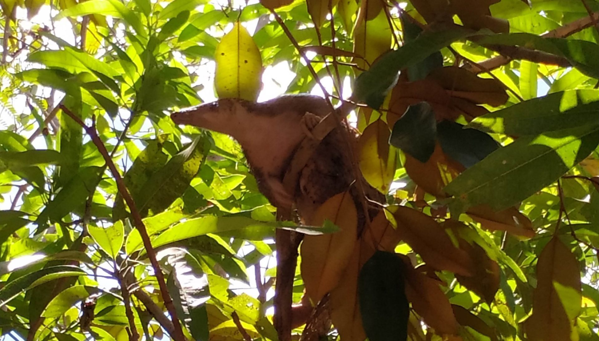
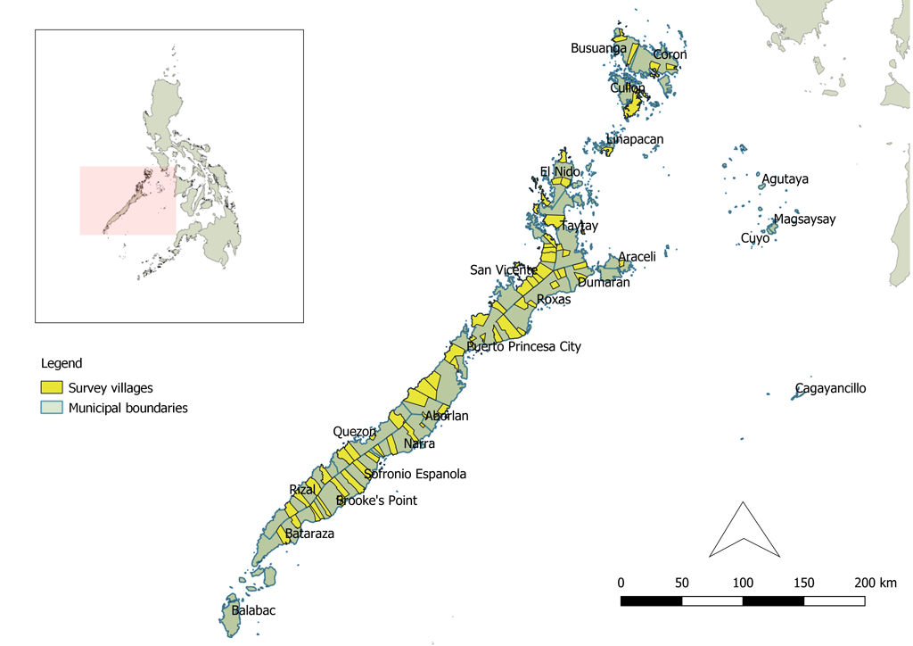
The shy, nocturnal pangolin — an animal that looks like a cross between an anteater and an artichoke — is hard to forget if you happen to see one. That’s what researchers from the United Kingdom and Philippines relied on when they sought out 1,296 residents of the Province of Palawan to describe their interactions with the critically endangered Philippine pangolins (Manis culionensis). Researcher Lucy Archer of the Zoological Society of London joined with the Philippines-based research team of Charity Apale, Darlyn Corona, Josefa Gacilos, and Ronald Amada to conduct interviews across the Palawan province in several languages, greatly enhancing their understanding of pangolin habitat and its interactions with human settlements.

Close-up photo of a pangolin in the Philippines by Lucy Archer, ZSL Philippines


Traditional wildlife surveys can take significant amounts of time and are relatively expensive to perform at large spatial scales. In addition, they are often unreliable for rare, nocturnal, and semi-arboreal species that are difficult to detect, like the Philippine pangolin. So, Archer and her collaborators turned to people living throughout the historical range of the species for information. By recording when and where people had last seen a Philippine pangolin, and whether they thought populations were increasing or decreasing in size, the group was able to establish important baseline information about the geographic distribution and status of pangolin populations. At the same time, and just as importantly, this approach yielded an understanding of differences in threats to pangolins across local geographies, and in attitudes of local residents about engaging in conservation. 

Map of pangolin survey sites in the Philippines


“Aside from providing us with much clearer perspective on where pangolins still exist, the people we interviewed also expressed their willingness to conserve the species,” says project manage Charity Apale. “This gives us hope, knowing that the local people in Palawan show inclination towards conserving and protecting the Critically Endangered Philippine pangolin.” 

Archer agrees. “Local people living throughout Palawan province have provided us with a much clearer perspective on where pangolins still occur, and the differences in pangolin status throughout their geographic range,” she says. “With 87 percent  of respondents able to recognize and provide further information on pangolins, we believe local people are well placed to help guide and co-develop conservation efforts for the species.” 

Photo of researchers studying a map of the Philippines where pangolins are natively found by Lucy Archer, ZSL Philippines
Researchers study a map of the Philippines where pangolins are natively found by Lucy Archer, ZSL Philippines


Unfortunately, this work is urgently needed. The Philippine pangolin is one of eight extant pangolin species worldwide, all of which have been placed on the IUCN Red List of Threatened Species, are hunted for meat, and are covered in scales that are trafficked for traditional medicines. Beyond the direct threats posed by trapping and hunting, palm oil plantations are supplanting pangolin habitats at a rapid rate, and climate change poses a diverse set of indirect threats to populations.

Despite the challenges faced by Philippine pangolin populations, Archer and her collaborators are optimistic that their study results will enable conservation action. People living throughout Palawan have provided them with a much clearer perspective on where pangolins occur and on differences in local perceptions of pangolins throughout their geographic range. Both kinds of geographic information will be essential as conservation efforts for pangolins continue to take shape.

Archer, L. J., Papworth, S. K., Apale, C. M., Corona, D. B., Gacilos, J. T., Amada, R. L., Waterman, C., & Turvey, S. T. (2020). Scaling up local ecological knowledge to prioritise areas for protection: Determining Philippine pangolin distribution, status and threats. Global Ecology and Conservation, 24, e01395.


    Share

On the Map: The Wry Smile of Sable Island

Picture of Sable Island in an atlas.

When you next find yourself moving your eyes or navigating a finger across a map of the Northwest Atlantic, you may be in for a surprise. About 175 km southeast of Nova Scotia, a seam appears on the surface of the ocean and opens up, ever-so-slightly, into a wry smile. 

An adjacent label should offer a name: Sable Island.


Sable Island pictured in an atlas in isolation.


Really? Can we be sure about this? The island is an anomaly, way out in the Atlantic, and there is nothing nearby that seems to justify its existence, geologically speaking. So it’s hard not to wonder about its position on the map, and its presence in the physical world. 

It is tempting to imagine that the island’s unusually graceful outline might indicate the presence of a clever cartographer — one who has inserted a fictitious landmass in the Atlantic to suss out copycat mapmakers. There are precedents for such behavior on land after all: Ever heard of a “trap street”?

But a quick internet search confirms that Sable Island does exist. It is a place of sand, wind, waves, a single Scots pine (the only survivor of more than 80,000 trees planted since 1900), and feral horses, among other things. 

Map of Sable Island
Map of Sable Island.


Looking closer, Sable Island yields quirks far better than any tricky mapmaker could. For starters, it looks like a barrier island but is located much further from the coastline than typical barrier islands. It likely formed from a terminal moraine — a mass of rocks and sediment carried down and deposited by a glacier, — sometime during the last Ice Age. That origin story may also help to explain the unexpected stability of some of the island’s dune structures. 

Over the last several centuries, Sable Island has also been notorious for attracting shipwrecks. Some 350 ships have succumbed to the sand bars, thick fog, and difficult currents characteristic of the area. Most of their remains have been crushed by waves and buried in the sand, making a full census impossible.


Sable Island map showing the location of the known wrecks upon the island
Sable Island map showing the location of the known wrecks upon the island.


Despite challenges of navigating to and from Sable Island, a rich history of research began there in 1871 with establishment of the Meteorological Service of Canada. Since then, research has expanded to include studies of climate, geomagnetism, and ecology. 

In 2013, Sable Island became protected as a National Park Reserve with the approval of Mi’kmaq stakeholders. Full national park status has yet to be achieved, pending settlement of Indigenous Peoples’ land claims within the Made in Nova Scotia Process. 

    Share

The Future Is Here: Sophia Garcia and the Intersections of GIS, Redistricting, and Social Justice

Photo of Sophia Garcia padding a raft in river rapids

We’re celebrating the accomplishments of geographers during Geography Awareness Week (November 14-20) and beyond. Find out more about this year’s theme, “The Future Is Here: Geographers Pursue the Path Forward” at our GeoWeek StoryMap, and follow the celebration at #GeoWeek or #GeoWeek2021.

Photo of Sophia GarciaSophia Garcia, the GIS and Outreach Director for Redistricting Partners in Sacramento, CA, understands how maps can start necessary conversations. In her current role, she sees redistricting efforts and community involvement as the “perfect intersection of talking about community, uplifting the community and letting them know what’s happening.” In her work she focuses on the imperative that we bring light to the redistricting process, engage communities, and empower them to get involved.

Garcia graduated with a bachelor’s degree in Environmental Studies from Wellesley College in 2015, and now works for Redistricting Partners from her base in Bakersfield, California. Garcia came to her current role from her previous work as a GIS Analyst for the Dolores Huerta Foundation, where she saw firsthand how she could uplift the work of her colleagues and community organizers through mapping. GIS software has great potential to start a dialogue and Garcia knows this:

Data is more than just numbers; there’s a story behind what’s happening.

Although she grew up with a father who worked in the GIS field (she attended her first ESRI User Conference when she was 10 years old, and mainly remembers the refreshments), Garcia did not see the full potential of GIS until college. Along with her classmates, she was tasked with figuring out how people living in a certain census block could do something sustainable surrounding food and grocery shopping. After knocking on doors and having conversations with people in the neighborhood, she found that not everyone had access to the nearest grocery store because of factors such as affordability, distance, and access to transportation.

Photo of Sophia Garcia padding a raft in river rapids
In addition to her work with GIS and redistricting, Sophia is a skilled rafter and rafting guide.


Because of the geographic nature surrounding the factors of access to food and sustainability, Garcia had an “aha moment” and realized the stories of everyone she had talked to could be conveyed using a map. She started to work with GIS on the project, and eventually went on to intern with the GIS departments in Kern County to learn more about the different ways that the departments utilized GIS.

At Redistricting Partners, Garcia has been very successful in using mapping technologies and outreach to emphasize the real-world implications of redistricting, and advocate for a more fair process. She was part of the group that sparked the passage of the California Assembly Bill No. 849, which mandates rules to increase transparency in the redistricting process in cities and counties across California. This bill, which Garcia hopes to see similarly implemented in other parts of the country, requires localities to have specific redistricting websites and mandates redistricting to be talked about during long public meetings, among other components.

When asked how younger geographers can explore new, interdisciplinary possibilities in geography, Garcia urges them to find a project they are passionate about and make use of mapping technology which is often available from ESRI to college and K-12 students. She recognizes that you can categorize pretty much any data geographically, and urges young geographers to “find whatever you’re passionate about, or mad about, or excited about, and learn to map it, make it as a poster, share it with someone, and you can have a discussion about it.”

    Share

Anthony O. Gabriel

Anthony O. Gabriel, professor of geography at Central Washington University, died Tuesday, September 14, 2021, after a valiant 14-month battle with cancer. He was 56. He was called home to God at his home surrounded by his loving family.

Anthony was born to Oswald Gabriel and Ursula Duhr in Vancouver, B.C., Canada in October 1964.  He grew up in Langley, B.C. and attended Trinity Western University.  He went on to complete his Master’s degree at Western Washington University where he met and married his wife, Marikay Douvier.  Anthony continued to complete his Ph.D. in Geography at the University of Guelph in Guelph, Ontario.

Anthony was a professor in the geography departments at Western Washington University, University of Wisconsin-Oshkosh and finally, for the last 20 years, at Central Washington University.  Through is love of teaching and research, he helped to mold the future of many students. He always went over and above to serve his department and his students. He successfully supervised over 30 Masters of Science theses.

Together Anthony and Mari welcomed two children, Katie and Zach. Anthony was very proud and supportive of his children, as he was involved in their education, extra-curricular activities, and life lessons. He always encouraged his children to pursue their dreams and goals.

Anthony was a devout member of St. Andrew’s Catholic Church. He enjoyed camping and fishing, walking his dogs, playing pool in the Ellensburg Pool League and being a 4-H leader for On Target Shooting Sports.

Anthony was a remarkable, very generous, and caring person, completely devoted to his family. He mentored many young faculty members in the department of geography at Central Washington University, helping them navigate work-family balance. He will be especially missed for his hilarious (and unique) sense of humor and how he loved to make people laugh.

Anthony was preceded in death by his father, Oswald Gabriel. Anthony is survived by his wife Mari, daughter Katie, son Zach, mother Ursula Gabriel, sister Angela Gabriel-Morrissey, brother-in-law Chris Morrissey, as well as numerous in-laws (and out-laws), nephews and nieces.

    Share

Bobby M. Wilson

Dr. Bobby M. Wilson, Emeritus Professor of Geography at the University of Alabama, who was a widely recognized leader in anti-racist scholarship, passed away on August 25th, 2021.

Dr. Wilson grew up on a farm in Warrenton, North Carolina where his responsibilities on the farm shaped his character and strength. It was also in Warrenton that he participated in the struggle for civil rights in the early 1960s. Later, he would attend North Carolina Central University, which was one of the few historically Black colleges that offered an undergraduate degree in geography. He earned a B.A. in Geography there and then received a fellowship to attend Clark University, where he earned a M.A. (1973) and Ph.D. (1974).

His first teaching position was in the Department of Urban Studies at the University of Alabama at Birmingham, from 1974-2002. He moved to the University of Alabama (in Tuscaloosa) in 2002, where he stayed for nearly two decades pursuing anti-racist scholarship. He also served as interim chair and retired as professor emeritus in 2015. Fittingly, his office in Farrah Hall was only a few steps away from Malone Hood Plaza on The University of Alabama campus, which celebrates the desegregation of the University of Alabama. His proximity to the plaza is symbolic of Dr. Wilson’s long dedication to anti-racist scholarship.

Wilson was active in several research areas including Urban and Social Geography; Urban Studies; Black Geographies; and the civil rights movement. His publications cover topics including Black perspectives on labor geographies, racial capitalism, urban planning, and residential segregation. His most notable publications were America’s Johannesburg: Industrialization and Racial Transformation in Birmingham, and Race and Place in Birmingham: The Civil Rights and Neighborhood Movements, both published in 2000. These books explore crucial links between the civil rights movement, the unique rise of industrial development in Birmingham, and Alabama’s former slaveholding plantation economy. These books are highly regarded in a variety of disciplines from Urban Studies to Economic Geography for their clear analysis of the spatial dimensions of race and exploitation of Black labor during industrialization. As a testament to the lasting importance of his work, The University of Georgia Press republished America’s Johannesburg in 2019.

In addition to being a member of the American Institute of Certified Planners and the Editorial Board, of AntipodeA Radical Journal of Geography, Dr. Wilson was also a long-time member of the American Association of Geographers and was active in the Southeast Division (SEDAAG). He served on the Editorial Committee, of Southeastern GeographerJournal of the Southeastern Division, Association of American Geographers, the Editorial Board, of Annals of the Association of American Geographers, and AAG’s Commission on Afro-American Geography.

He was recognized by the AAG with a Presidential Achievement Award in 2012, and both a Rose Award for Anti-Racism Research and Practice and the AAG Lifetime Achievement Award in 2015. The latter in “recognition of his extraordinary contributions to the scholarship of urban and social geography, urban studies, and anti-racist theory and practice; his teaching and mentoring; as well as his exemplary leadership in support of geography.”

Dr. Wilson is remembered fondly by many former colleagues and students at the University of Alabama and elsewhere.

    Share

Sanford Bederman

Sanford H. Bederman, 89, of Johns Creek, Georgia, died on 19 August 2021 from complications of cancer. A graduate of the University of Kentucky and a U.S. Army veteran who served in Germany in the 1950s, he received his M.A. from Louisiana State University in 1957, and Ph.D. in Geography from the University of Minnesota in 1973.

Bederman began teaching at Georgia State College of Business Administration in 1959, and in 1974 he was promoted to Full Professor at what became Georgia State University.  His primary area of interest was Africa, with time spent in the field in Nigeria, Cameroon, Tanzania, Kenya and Morocco pursuing research supported by the NSF, the Rockefeller Foundation and Georgia State University. Over the years, Bederman held several visiting professorships including at Queen Mary University, University of London.

Bederman was recognized as a gifted teacher who taught and advised generations of students and was also a prolific writer, with many publications including articles in The Oxford Companion to Exploration for which he served as the Africa Section editor.

Bederman retired from GSU in 1992, concluding 34 years of service. From 1993-95 he was a Visiting Professor at The University of Georgia, and thereafter he continued to teach at the Senior University of Greater Atlanta. Bederman was active in The Society for the History of Discoveries, serving as Executive Secretary in 2006. He was an Honorary Life Member of the Southeastern Division of the Association of American Geographers, and a Fellow of the Royal Geographical Society.

    Share

John Herbert Galloway

John (‘Jock’) Herbert Galloway died on July 27, 2021 in Tweed, Ontario, after suffering several years with Alzheimer’s.

Jock, as he always preferred to be known, graduated with a BA in Geography from McGill University in Montreal in 1960, an MA in Geography from the University of California at Berkeley in 1961, and a PhD from University College London in 1965. His doctoral research, conducted under the supervision of Professor Clifford Darby, focused on the historical geography of Pernambuco in Northeastern Brazil, from 1770 to 1920. Jock was appointed a Lecturer at the University of Toronto, St. George in 1964, and then an Assistant Professor in 1965. He was promoted to Associate- and Full-Professor ranks in 1970 and 1977, respectively. Jock retired from the University in 2005 when he was appointed Professor Emeritus. During his many years at the University of Toronto, Jock was a devoted and much loved and respected member of the Department of Geography & Planning as well as at Victoria College where he was a long-time Fellow.

Jock’s research and publications focused on the historical geography of Brazil and the Caribbean, leading to his monograph, The Sugar Cane Industry. An historical geography from its origins to 1914 published by the Cambridge University Press in 1989.  Exploring the global geographical diffusion of the sugar cane industry and its various branches, it is now considered a classic reference on the subject. Jock was a Fellow of the Royal Geographical Society and the American Geographical Society, and a member, among others, of the Canadian Association of Geographers (CAG) and the Barbados Museum and Historical Society. He served as Associate, Acting-Editor, and then Editor for the Canadian Geographer from 1966 to 1973, and on the editorial board of the Journal of Historical Geography from 1974 to 1978 and again from 1984 to 1994. He was the Review Editor for the Americas for the same journal from 1978 to 1983. From the late 1980s to the 2000s, Jock served on editorial boards for other periodicals including Latin American Studies, and the Luso-Brazilian Review of the University of Wisconsin Press. Pursuing his interest in sugar and his links with similarly minded people around the world, from 1994 to 2005 he co-edited the World Sugar History Newsletter. Over his long academic career, Jock published numerous articles and chapters, and delivered dozens of symposia papers and invited lectures. He also received several awards from his peers, including the Award for Scholarly Distinction from the CAG, and an Outstanding Teaching Award from the University of Toronto.

Jock will be remembered as a wonderful colleague and dedicated teacher. He was in personal life a Renaissance man, urbane, witty, multi-lingual, culturally engaged, and a great cook. Since his retirement, colleagues and students have often reminisced about seeing Jock in the hallways of Sidney Smith Hall, always dressed impeccably, and very often rushing with maps rolled under his arms, on his way to give a lecture. Jock will be remembered as a scholar as well as consummate gentleman who was always supportive of his colleagues and students.

5 August 2021

    Share

Roger Kasperson

Former Clark Graduate School of Geography faculty member Roger Kasperson, passed away on Saturday, April 10. A major scholar in the fields of risk and environmental sustainability, Professor Kasperson had a nearly lifelong relationship with Clark and the GSG: he earned his B.A. in Geography from Clark in 1959, and returned to Clark as a faculty member in Geography and Government in 1968 after earning his M.A. and Ph.D. in Geography at the University of Chicago and teaching elsewhere for several years. He spent the majority of his career at Clark, in a variety of roles: in addition to being an assistant, associate, and full professor in our department, he headed a number of major centers and initiatives at Clark and served at various points as Acting Director of the GSG, Dean of the College, Provost and Vice President for Academic Affairs, and University Professor. He retained an appointment as a Research Faculty member in our department up until the time of his death.

Professor Kasperson was a major figure in the fields of risk analysis and communication, global environmental change, and vulnerability, sustainability, and resilience. As such, he worked closely with a variety of government agencies and NGOs, including the National Research Council, the International Geographical Union, and the Potsdam Institute for Climate Change. Perhaps most notably, he was the Executive Director of the Stockholm Environment Institute from 2000-2004. He was also an elected member of the National Academy of Sciences, the American Academy of Arts and Sciences, and the American Association for the Advancement of Science, and a recipient of honors from both the AAG and the Society for Risk Analysis.

Thank you to the Graduate School of Geography at Clark University for permission to publish this obituary. Original found here.

    Share

Nancy Hultquist

Nancy B. Hultquist, retired Central Washington University (CWU) geography professor, died March 30th, 2021. During her geographic career she was an active member of the American Association of Geographers (over 50 years), the National Council for Geographic Education (NCGE), and the Washington Geographic Alliance (WGA). Nancy is remembered fondly by students, friends, and colleagues. She was quick to assist junior faculty and devoted countless hours to helping students find employment.

Like many geographers, Nancy was drawn to the field early in her academic career. Also, like many geographers, she had many non-academic interests including bowling, raising Brittneys, and playing the fiddle.

Born in 1943, Nancy grew up in Atlanta, GA where she lived near a 32-lane bowling alley. There she worked and became good at the sport. (Nancy holds the record of High Series (679) for Women in Moscow, ID.) She completed her undergraduate degree in 1965 at Georgia State University and then on to Graduate school, first at the University of Cincinnati and then on to the University of Iowa. Along the way she married John (also a geographer) in 1969. From the farming country of Iowa came the first Brittany. Then the University of Idaho beckoned (1974), and the three headed further west.

The Moscow university provided a split position that Nancy and John shared. Along the way she gained knowledge and teaching experience using computers to make detailed maps. Like so many of her contemporaries, Nancy started out with key-punch cards and eventually moved on to Geographic Information Systems (GIS). Countless K-12 teachers were introduced to the early iterations of making maps and GIS through NCGE workshops she participated in with Paul Baumann.

In 1988, Nancy joined the CWU geography department as the first full-time, tenure-track woman faculty member. There, she became involved with an Army initiated (GRASS) GIS program. Initially the program used CWU faculty to do mapping for the Army’s Yakima Firing Center/Training Center. Nancy expanded the program to include undergraduate GIS classes and was instrumental in moving the program along. Her popular classes grew, and she soon had students presenting their GIS projects at professional meetings. It is little wonder that, as an advisor, she supervised more interns than any other geography department faculty.

Other than her love of geography and dogs, (their kennel name – Cedaridge Brittanys – was known throughout the Nation) Nancy was also a talented musician. She first played the fiddle at the age of 4 and, as an additional outlet for her boundless energy, joined a group named Kittitas Valley Fiddlers and Friends. Heart issues from a childhood case of Rheumatic fever ended her academic career, but only interrupted her fiddle playing. Major heart surgery came in 2009. Her surgeon told her she was spared because there was more for her to do on Earth.

As she recovered and gained stamina, Nancy began to take a larger role in the music of the Kittitas Valley Fiddlers and Friends. They played at elder care facilities in Ellensburg and other venues in the area, especially at the Adult Activity Center. The photo accompanying this text is from this period. She considered the entertainment provided to the residents of the valley in these facilities one of her best experiences.

Nancy was known as a great teacher and an even greater supporter of student success. She maintained a jobs list of employment opportunities across the Pacific Northwest which currently has over 800 subscribers. Many CWU alumni credit her tireless work to helping them launch their career. The list will continue, serving as a living memorial to her impact. Please take a moment to remember Nancy B. Hultquist as a shining light to students, colleagues, and friends.

    Share

Allen G. Noble

Dr Allen G. Noble, Professor Emeritus at the University of Akron, Ohio and a longtime AAG member, passed away on March 24. He was 90 years old.

In his early career, Dr. Noble served as a United States Foreign Service Officer in Bombay, India, and Curitiba and Belém, Brazil. He went on to a distinguished academic and publishing career in regional, cultural, and physical geography. His book Wood, Brick, and Stone: The North American Settlement Landscape was nominated for a Pulitzer Prize in 1984. In the late 1980s, AAG recognized Dr. Noble with the AAG Honors, the highest award offered by the AAG. The Ohio Academy of Sciences cited him in their 100th Year Celebration as one of Ohio’s Distinguished Scientists.

Noble’s ability to keep his family goal oriented and organized will be greatly missed. He was predeceased by his daughter and is survived by his wife, two sons, four grandchildren and three great grandchildren

    Share